Erich é alemão, editor e fotógrafo, e eu sou arquiteta. Desenvolvemos uma parceria de trabalho e, em consequência, já publicamos três livros impressos e cinco digitais. Dois dos impressos versam sobre o estado do Rio Grande do Norte (66 Razões para descobrir o Rio Grande do Norte e deliciar-se com ele e Guia das Belezas do Rio Grande do Norte com exemplos de conservação ambiental), e o terceiro sobre o Brasil (66 x Brasil). Os livros digitais são: 66 x Brazil (somente em inglês), Natal e as belas praias do Rio Grande do Norte, Deserto do Atacama –Neve e Céu Azul, 66 Belezas do Brasil, 66 Sehenswürdigkeiten in Brasilien e Aventuras e Impressões de Viagens.Os três primeiros estão disponíveis na Ibooks da Apple e os outros na Amazon.com.São livros informativos e de fotografias, alguns dos quais contêm textos explicativos, em várias línguas, sobre os locais retratados. Viajamos muito para fotografar e conhecer os lugares que enfocamos em nossos livros.
A cidade de Colonia del Sacramento está localizada no sudoeste do Uruguay às margens do Río de la Plata, em frente a Buenos Aires.
Fonte/Quelle/Source: Google Maps
É uma das cidades mais antigas do país e foi fundada em 1680 pelos portugueses. Devido à sua posição estratégica, a cidade foi disputada durante muito tempo entre Portugal e Espanha. Essa história movimentada deixou um patrimônio arquitetônico único que ainda hoje está bem preservado. O bairro histórico, chamado Barrio Histórico, é especialmente famoso por suas ruas de pedra, casas baixas e antigas muralhas.
O centro histórico faz parte do Patrimônio Mundial da UNESCO desde 1995 e atrai visitantes de todo o mundo todos os anos. Caminhar pelas ruas estreitas é como voltar à época colonial. Muitos edifícios datam dos séculos XVII e XVIII e mostram uma mistura de estilos português e espanhol.
O símbolo da cidade é o antigo farol, de onde se tem uma bela vista sobre os telhados e o Río de la Plata. A Igreja Matriz, uma das mais antigas do Uruguai, também é um importante monumento histórico. Colonia del Sacramento não é apenas um lugar de história, mas também de tranquilidade e descanso. Pequenos cafés, restaurantes e lojas de artesanato convidam a permanecer e aproveitar o ambiente. À noite, a cidade fica especialmente romântica quando o sol se põe sobre o rio.
Muitos visitantes fazem um passeio de um dia desde Buenos Aires de barco, pois a travessia dura cerca de uma hora. Apesar da proximidade com a grande cidade, Colonia manteve seu caráter tranquilo e acolhedor. A cidade é um destino popular para amantes da cultura, fotógrafos e viajantes que desejam conhecer a América do Sul autêntica. A região ao redor, com praias e paisagens rurais, também oferece belos passeios.
Colonia del Sacramento é considerada uma das cidades mais bonitas do Uruguai e um lugar onde a história permanece viva.
Die Stadt Colonia del Sacramento liegt im Südwesten von Uruguay direkt am Río de la Plata gegenüber von Buenos Aires.
Fonte/Quelle/Source: Google Maps
Sie gehört zu den ältesten Städten des Landes und wurde im Jahr 1680 von den Portugiesen gegründet. Aufgrund ihrer strategisch günstigen Lage war die Stadt lange Zeit zwischen Portugal und Spanien umkämpft. Diese wechselvolle Geschichte hat ein einzigartiges architektonisches Erbe hinterlassen, das bis heute gut erhalten ist. Besonders bekannt ist das historische Viertel Barrio Histórico mit seinen gepflasterten Straßen, niedrigen Häusern und alten Stadtmauern. Die Altstadt gehört seit 1995 zum UNESCO-Weltkulturerbe und zieht jedes Jahr zahlreiche Besucher aus aller Welt an. Beim Spaziergang durch die engen Gassen fühlt man sich in die Kolonialzeit zurückversetzt. Viele Gebäude stammen noch aus dem 17. und 18. Jahrhundert und zeigen eine Mischung aus portugiesischem und spanischem Baustil. Wahrzeichen der Stadt ist der alte Leuchtturm, von dem aus man einen schönen Blick über die Dächer und den Río de la Plata hat. Auch die Kirche Matriz, eine der ältesten Kirchen Uruguays, ist ein bedeutendes historisches Bauwerk. Colonia del Sacramento ist nicht nur ein Ort für Geschichte, sondern auch für Ruhe und Entspannung. Kleine Cafés, Restaurants und Kunsthandwerksläden laden zum Verweilen ein. Besonders am Abend herrscht eine romantische Atmosphäre, wenn die Sonne über dem Fluss untergeht. Viele Besucher machen einen Tagesausflug von Buenos Aires mit der Fähre, da die Überfahrt nur etwa eine Stunde dauert. Trotz der Nähe zur Großstadt hat sich Colonia seinen ruhigen und gemütlichen Charakter bewahrt. Die Stadt ist ein beliebtes Ziel für Kulturinteressierte, Fotografen und Reisende, die das authentische Südamerika erleben möchten. Auch die Umgebung mit ihren Stränden und ländlichen Landschaften bietet schöne Ausflugsmöglichkeiten. Colonia del Sacramento gilt als eine der schönsten Städte Uruguays und als ein Ort, an dem Geschichte lebendig bleibt.
The city of Colonia del Sacramento is located in the southwest of Uruguay on the Río de la Plata, directly across from Buenos Aires. It is one of the oldest cities in the country and was founded in 1680 by the Portuguese. Because of its strategic location, the city was disputed for a long time between Portugal and Spain. This turbulent history left behind a unique architectural heritage that is still well preserved today. The historic quarter, known as Barrio Histórico, is especially famous for its cobblestone streets, low houses, and old city walls. The old town has been a UNESCO World Heritage Site since 1995 and attracts many visitors from all over the world every year. Walking through the narrow streets feels like traveling back to the colonial era. Many buildings date from the 17th and 18th centuries and show a mix of Portuguese and Spanish architectural styles. The city’s landmark is the old lighthouse, from which there is a beautiful view over the rooftops and the Río de la Plata. The Matriz Church, one of the oldest churches in Uruguay, is also an important historical monument. Colonia del Sacramento is not only a place of history but also of peace and relaxation. Small cafés, restaurants, and craft shops invite visitors to stay and enjoy the atmosphere. In the evening, the city becomes especially romantic when the sun sets over the river. Many visitors come on a day trip from Buenos Aires by ferry, as the crossing takes only about one hour. Despite its proximity to the big city, Colonia has preserved its calm and charming character. The city is a popular destination for culture lovers, photographers, and travelers who want to experience authentic South America. The surrounding area with its beaches and rural landscapes also offers beautiful excursions. Colonia del Sacramento is considered one of the most beautiful cities in Uruguay and a place where history remains alive.
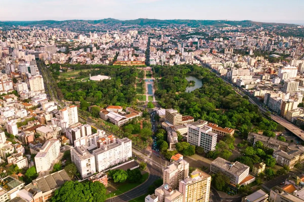
Porto Alegre é a capital do estado brasileiro do Rio Grande do Sul e uma das cidades mais importantes do sul do país. A cidade está situada às margens do Guaíba, que na verdade é um grande delta de rios e teve um papel importante na história e no desenvolvimento da região. Porto Alegre foi fundada em 1772 e rapidamente se tornou um importante centro comercial. Muitos dos primeiros colonos vieram de Portugal, mas imigrantes alemães, italianos e espanhóis também influenciaram fortemente a cultura da cidade. Essa influência europeia ainda pode ser vista hoje na arquitetura, nas tradições e na gastronomia.
A paisagem urbana de Porto Alegre é uma mistura de arranha-céus modernos, prédios históricos e grandes áreas verdes. Um dos lugares mais conhecidos é o Parque Farroupilha, também chamado de Redenção, que é um ponto de encontro popular para moradores e visitantes. Nos fins de semana acontecem feiras, eventos musicais e atividades culturais.
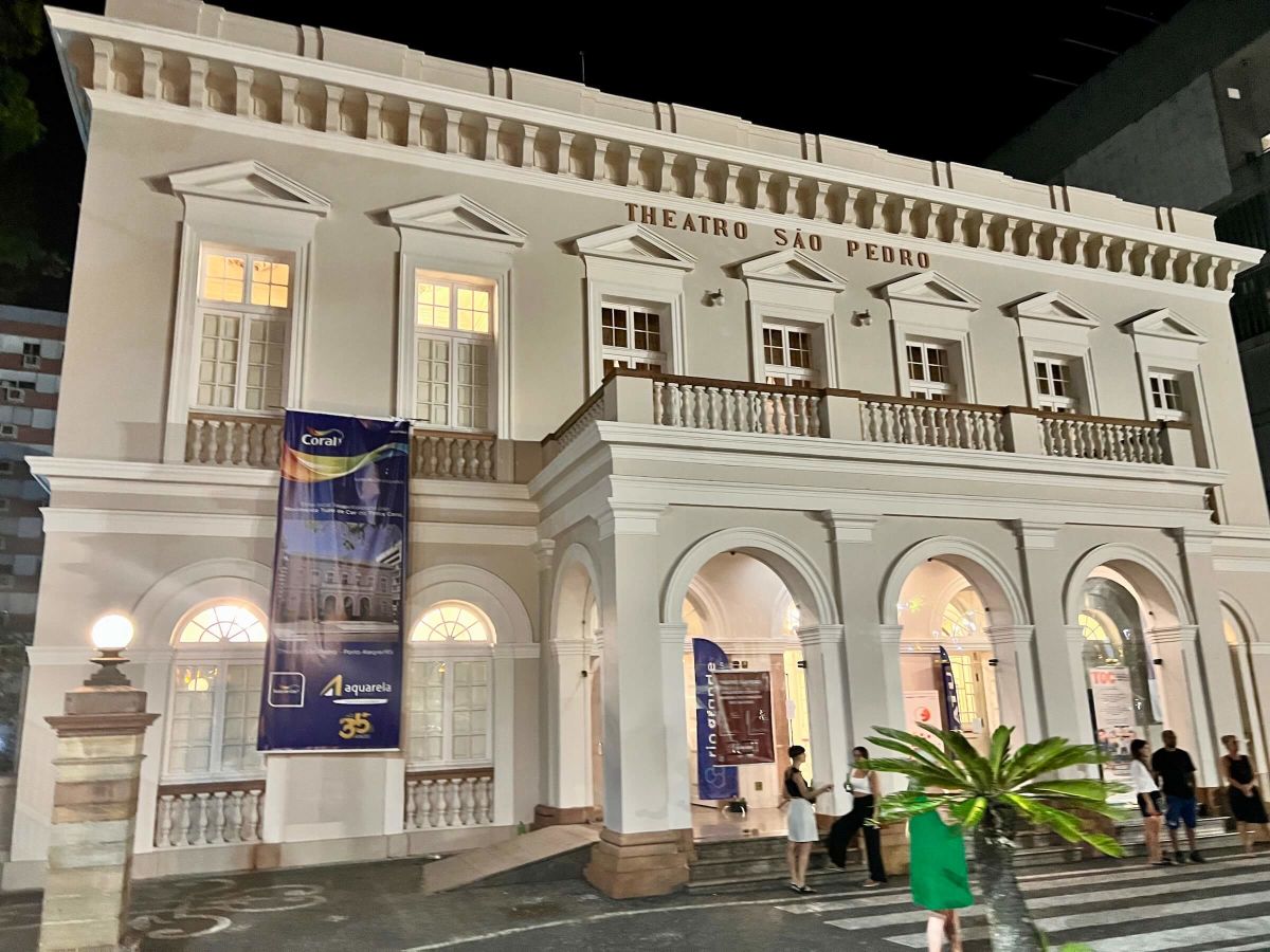
Outro símbolo da cidade é o centro histórico com suas igrejas antigas, museus e teatros. O Theatro São Pedro é uma das instituições culturais mais importantes do sul do Brasil.
Porto Alegre também é uma importante cidade universitária. A Universidade Federal do Rio Grande do Sul está entre as melhores do Brasil e atrai estudantes de todo o país. Por causa do grande número de jovens, a cidade tem uma vida cultural muito ativa com concertos, festivais e exposições. O esporte também tem grande importância. Os clubes de futebol Grêmio e Internacional estão entre os mais famosos do Brasil e conquistaram muitos títulos nacionais e internacionais.
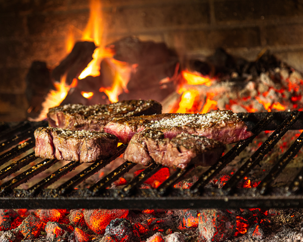
O clima em Porto Alegre é diferente de muitas outras cidades brasileiras, pois os invernos podem ser mais frios. No verão pode fazer muito calor, enquanto no inverno as temperaturas podem ficar abaixo de dez graus. Essas diferenças climáticas tornam a região bastante diversa. A culinária de Porto Alegre é fortemente influenciada pela cultura gaúcha. Um dos pratos mais populares é o churrasco, o tradicional churrasco brasileiro, que tem longa tradição nesta região.
Hoje, Porto Alegre é considerada uma cidade moderna, aberta e culturalmente diversa, que combina tradição e progresso. Por causa de sua localização no sul do Brasil, é um importante centro econômico e cultural e uma porta de entrada para os países vizinhos Uruguai e Argentina. Os visitantes apreciam a atmosfera tranquila, os belos pores do sol no Guaíba e as pessoas simpáticas que têm orgulho de sua cidade.
Porto Alegre ist die Hauptstadt des südbrasilianischen Bundesstaates Rio Grande do Sul und eine der wichtigsten Städte im Süden des Landes. Die Stadt liegt am Ufer des Guaíba-Sees, der eigentlich ein großer Flussdelta ist und eine bedeutende Rolle für die Geschichte und Entwicklung der Region spielt. Porto Alegre wurde im Jahr 1772 gegründet und entwickelte sich schnell zu einem wichtigen Handelszentrum. Viele der ersten Siedler stammten aus Portugal, aber auch deutsche, italienische und spanische Einwanderer haben die Kultur der Stadt stark geprägt. Noch heute erkennt man diesen europäischen Einfluss in der Architektur, in den Traditionen und in der Gastronomie.
Das Stadtbild von Porto Alegre ist eine Mischung aus modernen Hochhäusern, historischen Gebäuden und großen Grünanlagen. Besonders bekannt ist der Parque Farroupilha, auch Redenção genannt, der ein beliebter Treffpunkt für Einheimische und Besucher ist. Dort finden am Wochenende Märkte, Musikveranstaltungen und kulturelle Aktivitäten statt.
Ein weiteres Wahrzeichen der Stadt ist das historische Zentrum mit seinen alten Kirchen, Museen und Theatern. Das Theatro São Pedro gehört zu den wichtigsten kulturellen Einrichtungen im Süden Brasiliens.
Porto Alegre ist auch eine bedeutende Universitätsstadt. Die Bundesuniversität von Rio Grande do Sul zählt zu den besten Hochschulen des Landes und zieht Studenten aus ganz Brasilien an. Durch die vielen jungen Menschen hat die Stadt ein lebendiges kulturelles Leben mit Konzerten, Festivals und Ausstellungen. Auch sportlich spielt Porto Alegre eine große Rolle. Die beiden Fußballvereine Grêmio und Internacional gehören zu den bekanntesten Teams Brasiliens und haben viele nationale und internationale Titel gewonnen.
Das Klima in Porto Alegre unterscheidet sich von vielen anderen brasilianischen Städten, da es hier deutlich kühlere Winter gibt. Im Sommer kann es sehr heiß werden, während im Winter Temperaturen unter zehn Grad möglich sind. Diese klimatischen Unterschiede machen die Region besonders vielfältig. Die Küche von Porto Alegre ist stark von der Kultur der Gauchos geprägt. Besonders beliebt ist Churrasco, das traditionelle brasilianische Grillfleisch, das in dieser Region eine lange Tradition hat.
Heute gilt Porto Alegre als eine moderne, offene und kulturell vielfältige Stadt, die Tradition und Fortschritt miteinander verbindet. Durch ihre Lage im Süden Brasiliens ist sie ein wichtiges wirtschaftliches und kulturelles Zentrum und ein Tor zu den Nachbarländern Uruguay und Argentinien. Besucher schätzen die entspannte Atmosphäre, die schönen Sonnenuntergänge am Guaíba und die freundlichen Menschen, die stolz auf ihre Stadt sind.
Porto Alegre is the capital of the southern Brazilian state of Rio Grande do Sul and one of the most important cities in the south of the country. The city lies on the shores of Lake Guaíba, which is actually a large river delta and played an important role in the history and development of the region. Porto Alegre was founded in 1772 and quickly developed into an important trading center. Many of the first settlers came from Portugal, but German, Italian, and Spanish immigrants also strongly influenced the culture of the city. This European influence can still be seen today in the architecture, traditions, and cuisine.
The cityscape of Porto Alegre is a mix of modern skyscrapers, historic buildings, and large green parks. One of the most famous places is Farroupilha Park, also called Redenção, which is a popular meeting point for locals and visitors. On weekends, markets, music events, and cultural activities take place there.
Another landmark is the historic center with its old churches, museums, and theaters. Theatro São Pedro is one of the most important cultural institutions in southern Brazil.
Porto Alegre is also an important university city. The Federal University of Rio Grande do Sul is one of the best universities in Brazil and attracts students from all over the country. Because of the many young people, the city has a lively cultural life with concerts, festivals, and exhibitions. Sports also play an important role. The football clubs Grêmio and Internacional are among the most famous teams in Brazil and have won many national and international titles.
The climate in Porto Alegre is different from many other Brazilian cities, because winters can be much cooler. Summers can be very hot, while in winter temperatures below ten degrees Celsius are possible. These climate differences make the region very diverse. The cuisine of Porto Alegre is strongly influenced by the Gaucho culture. One of the most popular dishes is churrasco, the traditional Brazilian barbecue, which has a long tradition in this region.
Today, Porto Alegre is considered a modern, open, and culturally diverse city that combines tradition and progress. Because of its location in southern Brazil, it is an important economic and cultural center and a gateway to the neighboring countries Uruguay and Argentina. Visitors appreciate the relaxed atmosphere, the beautiful sunsets over the Guaíba, and the friendly people who are proud of their city.
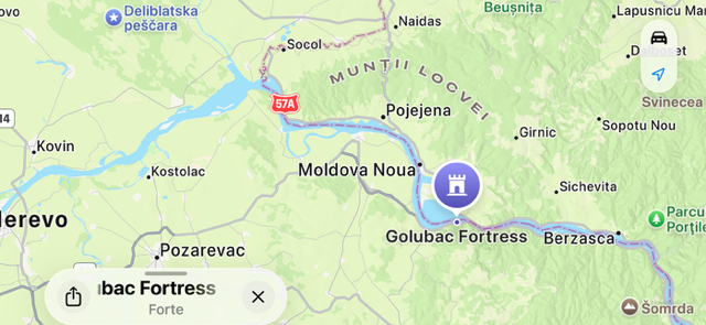
A Fortaleza de Golubac está situada de forma impressionante na margem direita do rio Danúbio, no leste da Sérvia, perto da fronteira com a Romênia. Ela se ergue no ponto onde o rio se estreita e marca a entrada do famoso Desfiladeiro do Portão de Ferro.
Fonte/Source/Quelle: Google Maps
Com suas muralhas imponentes e dez torres marcantes, a fortaleza parece saída de um conto de fadas. Golubac foi construída na Idade Média, provavelmente no século XIV, e teve grande importância estratégica. Devido à sua localização, foi disputada durante séculos por húngaros, sérvios e otomanos. A fortaleza servia para controlar o tráfego fluvial no Danúbio e proteger importantes rotas comerciais. É especialmente impressionante a harmonia entre a arquitetura e a natureza, pois as muralhas parecem surgir diretamente das rochas. Atualmente, a Fortaleza de Golubac foi cuidadosamente restaurada e está aberta à visitação. Trilhas, mirantes e exposições oferecem uma visão profunda da história da região. Das torres, é possível apreciar vistas espetaculares do Danúbio e do Parque Nacional Đerdap. A Fortaleza de Golubac é considerada uma das mais belas e bem preservadas fortalezas medievais da Sérvia e atrai tanto amantes da cultura quanto da natureza.
Para saber mais sobre a Fortaleza Golubac, clique aqui.
Die Festung Golubac liegt eindrucksvoll am rechten Ufer der Donau im Osten Serbiens, nahe der Grenze zu Rumänien. Sie erhebt sich dort, wo sich der Fluss dramatisch verengt und den Eingang zum berühmten Eisernen Tor markiert.
Fonte/Source/Quelle: Google Maps
Mit ihren massiven Mauern und zehn markanten Türmen wirkt die Festung wie aus einem Märchen entsprungen. Errichtet wurde Golubac im Mittelalter, vermutlich im 14. Jahrhundert, und spielte eine bedeutende strategische Rolle. Aufgrund ihrer Lage war sie über Jahrhunderte hinweg ein umkämpfter Punkt zwischen Ungarn, Serben und Osmanen. Die Festung diente zur Kontrolle des Schiffsverkehrs auf der Donau und zur Sicherung wichtiger Handelsrouten. Besonders beeindruckend ist die harmonische Verbindung von Architektur und Natur, da die Mauern direkt aus den Felsen zu wachsen scheinen. Heute ist Golubac aufwendig restauriert und für Besucher zugänglich. Spazierwege, Aussichtspunkte und Ausstellungen ermöglichen einen tiefen Einblick in die Geschichte der Region. Von den Türmen aus eröffnet sich ein spektakulärer Blick auf die Donau und den Đerdap-Nationalpark. Die Festung Golubac gilt als eines der schönsten und besterhaltenen mittelalterlichen Bauwerke Serbiens und ist ein beliebtes Ziel für Kultur- und Naturliebhaber gleichermaßen.
Um mehr über die Festung Golubac zu erfahren, klicken Sie hier.
The Golubac Fortress is dramatically located on the right bank of the Danube in eastern Serbia, close to the Romanian border. It rises at the point where the river narrows and marks the entrance to the famous Iron Gate gorge.
Fonte/Source/Quelle: Google Maps
With its massive walls and ten striking towers, the fortress looks like something from a fairy tale. Golubac was built in the Middle Ages, probably in the 14th century, and played an important strategic role. Due to its location, it was contested for centuries by Hungarians, Serbs, and Ottomans. The fortress was used to control river traffic on the Danube and to protect key trade routes. Particularly impressive is the harmony between architecture and nature, as the walls seem to grow directly out of the rock. Today, Golubac Fortress has been carefully restored and is open to visitors. Walking paths, viewpoints, and exhibitions offer deep insight into the region’s history. From the towers, visitors enjoy spectacular views of the Danube and the Đerdap National Park. Golubac Fortress is considered one of the most beautiful and best-preserved medieval fortresses in Serbia and is a popular destination for both cultural and nature tourism.
To learn more about the Golubac Fortress, click here.
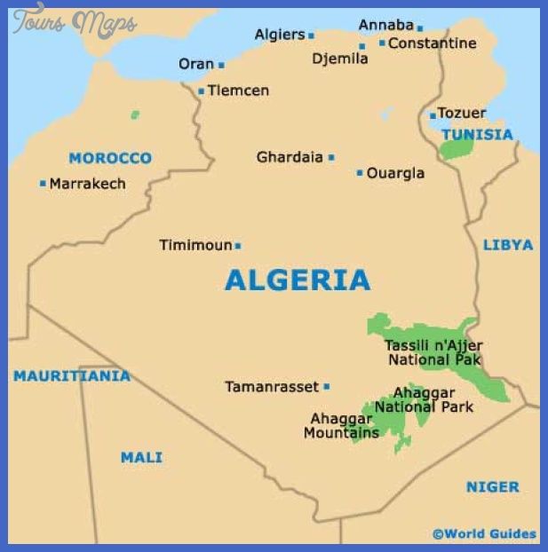
A Argélia é o maior país da África e reúne uma impressionante diversidade de paisagens, história e cultura, que vão do litoral mediterrâneo ao vasto Deserto do Saara.
Fonte/Quelle/Source: World Guides/Tours Maps
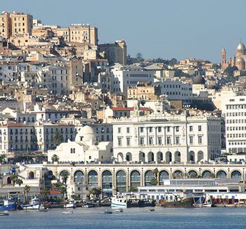
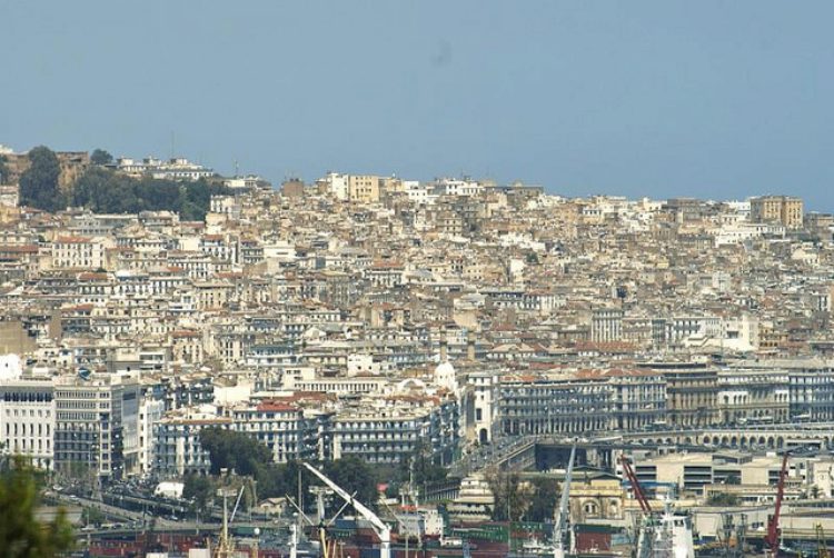
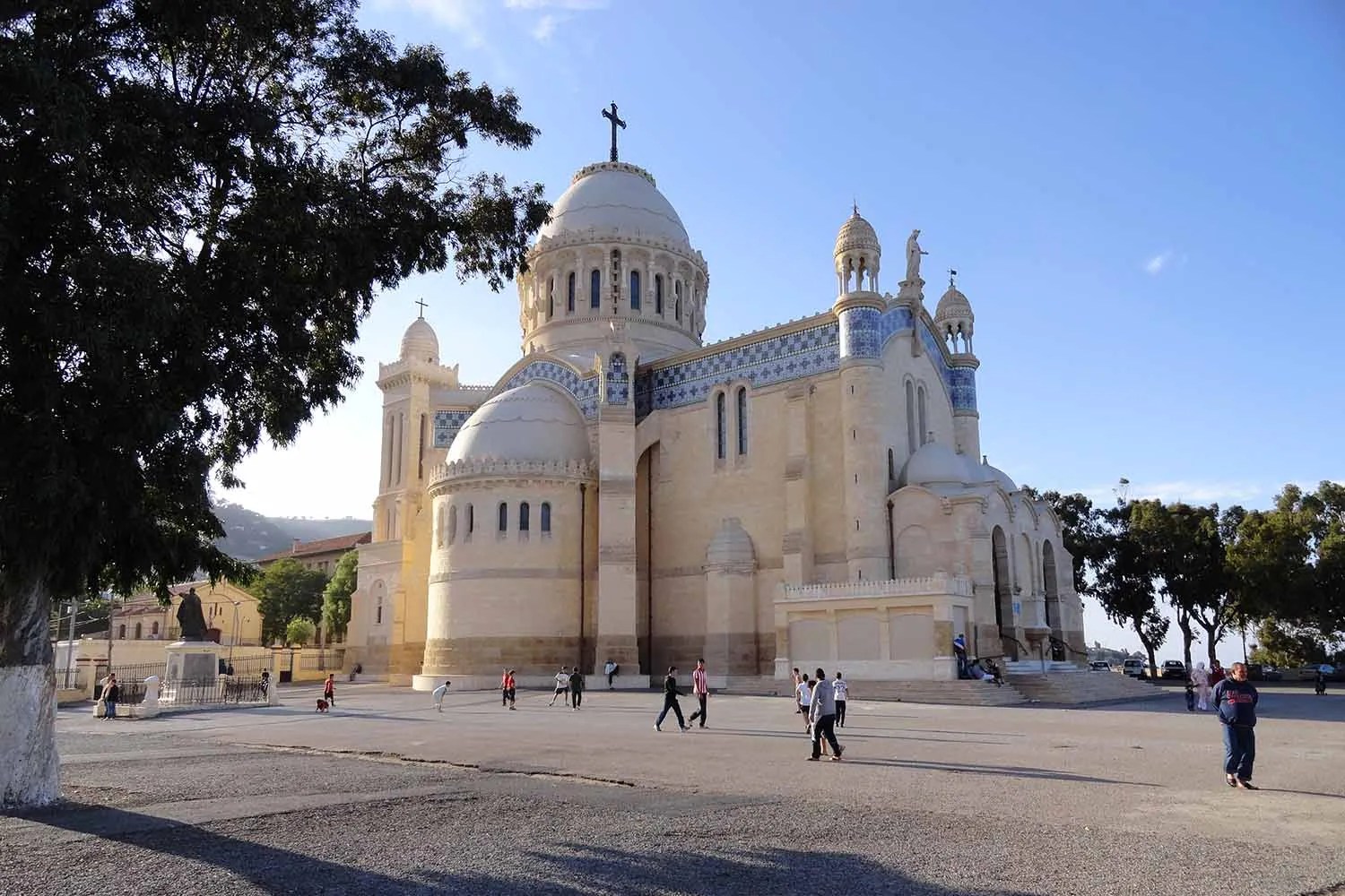
A capital, Argel, está localizada no norte do país, às margens do Mar Mediterrâneo. Um de seus principais pontos turísticos é a Casbá de Argel, um antigo bairro histórico reconhecido como Patrimônio Mundial da UNESCO, com ruas estreitas, palácios otomanos e vistas panorâmicas do mar.
Argel é o centro político, econômico e cultural do país. Construções coloniais francesas ainda marcam muitos bairros.Ao mesmo tempo, surgem arranha-céus modernos e novos projetos urbanos.
Seu porto a torna um importante ponto de comércio e transporte.
Museus, teatros e universidades enriquecem a vida cultural.
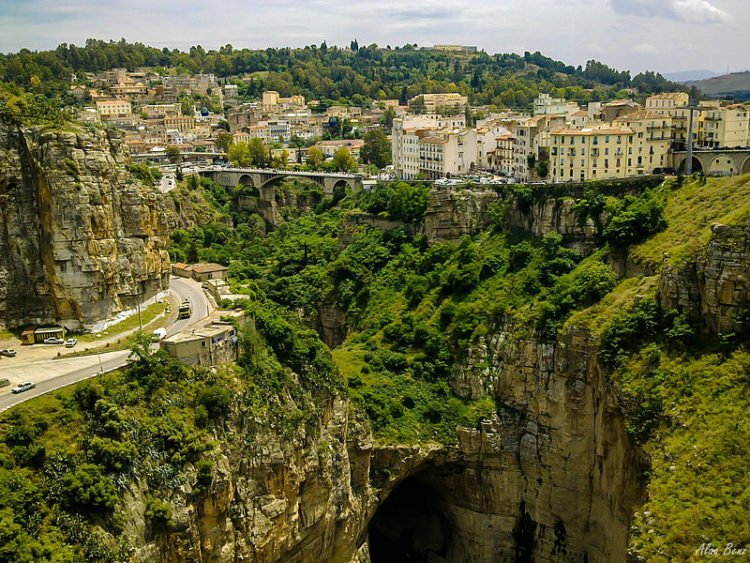
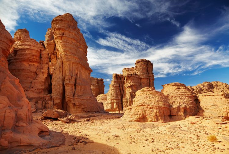
Na região norte também se destaca Constantine, famosa por suas pontes suspensas construídas sobre profundos desfiladeiros.
A cidade abriga importantes monumentos históricos e oferece paisagens urbanas únicas. Constantine está situada de forma espetacular sobre penhascos rochosos e cercada por gargantas profundas. A cidade é famosa por suas numerosas pontes que cruzam os abismos. É uma das cidades mais antigas da Argélia, com mais de 2.000 anos de história. Fenícios, romanos e árabes deixaram suas marcas ali. Constantine é um importante centro de cultura e educação islâmica. Mesquitas e edifícios históricos definem sua paisagem urbana. A natureza ao redor é impressionante e singular. Tradições, música e artesanato permanecem vivos.
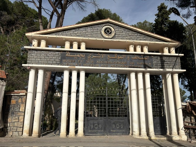
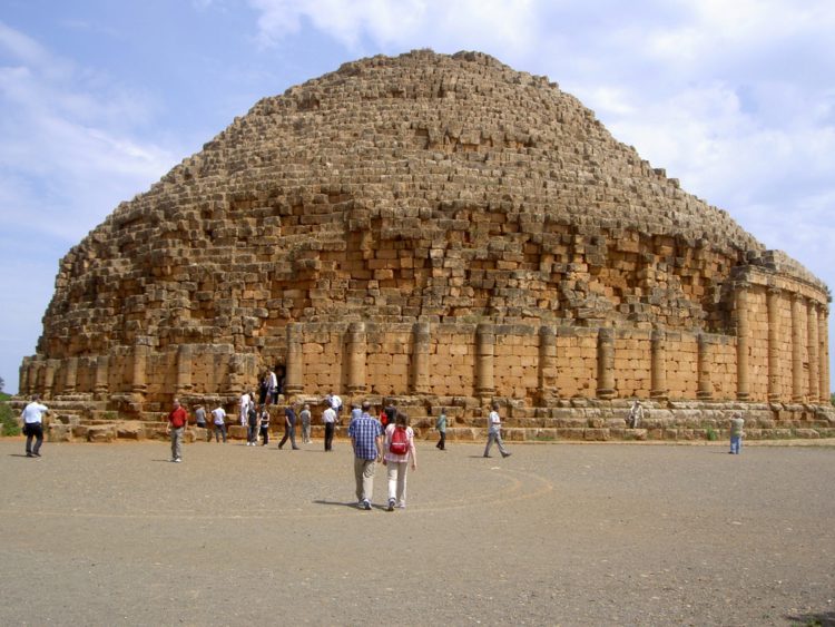
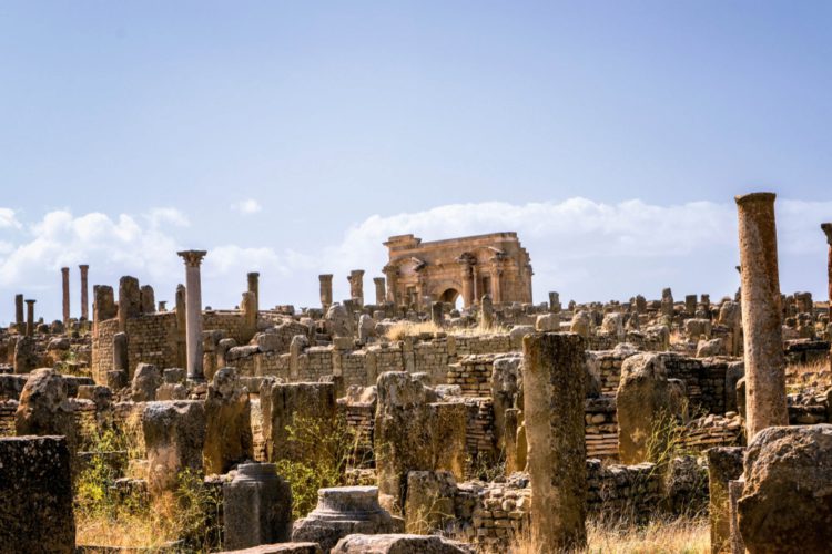
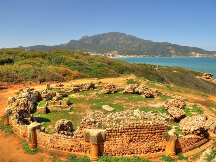
No leste do país, próximo à cidade de Sétif, encontram-se as ruínas romanas de Djamila,
Ela é conhecida principalmente por suas impressionantes ruínas romanas. A antiga cidade de Cuicul é Patrimônio Mundial da UNESCO. Templos, mosaicos e ruas bem preservados lembram sua prosperidade romana. A localização nas montanhas cria uma atmosfera especial.Djamila foi um importante centro de comércio e cultura. Descobertas arqueológicas revelam o cotidiano da Antiguidade. As ruínas estão entre as mais belas do Norte da África. Hoje, Djamila é um destino relevante para amantes da cultura.
O local une patrimônio histórico e beleza natural.
Oran, no noroeste da Argélia, é uma importante cidade portuária. Sua história foi marcada por influências espanholas e francesas. A cidade é famosa por sua cena musical, especialmente o Rai.Avenidas modernas convivem com fortalezas e bairros históricos.
Oran é um centro econômico e industrial relevante. A localização costeira lhe confere um caráter mediterrâneo. Cafés, mercados e praças moldam a vida cotidiana.
A cidade é jovem, dinâmica e diversa.Oran inspirou obras literárias e cinematográficas.
Hoje, representa modernidade e energia cultural.
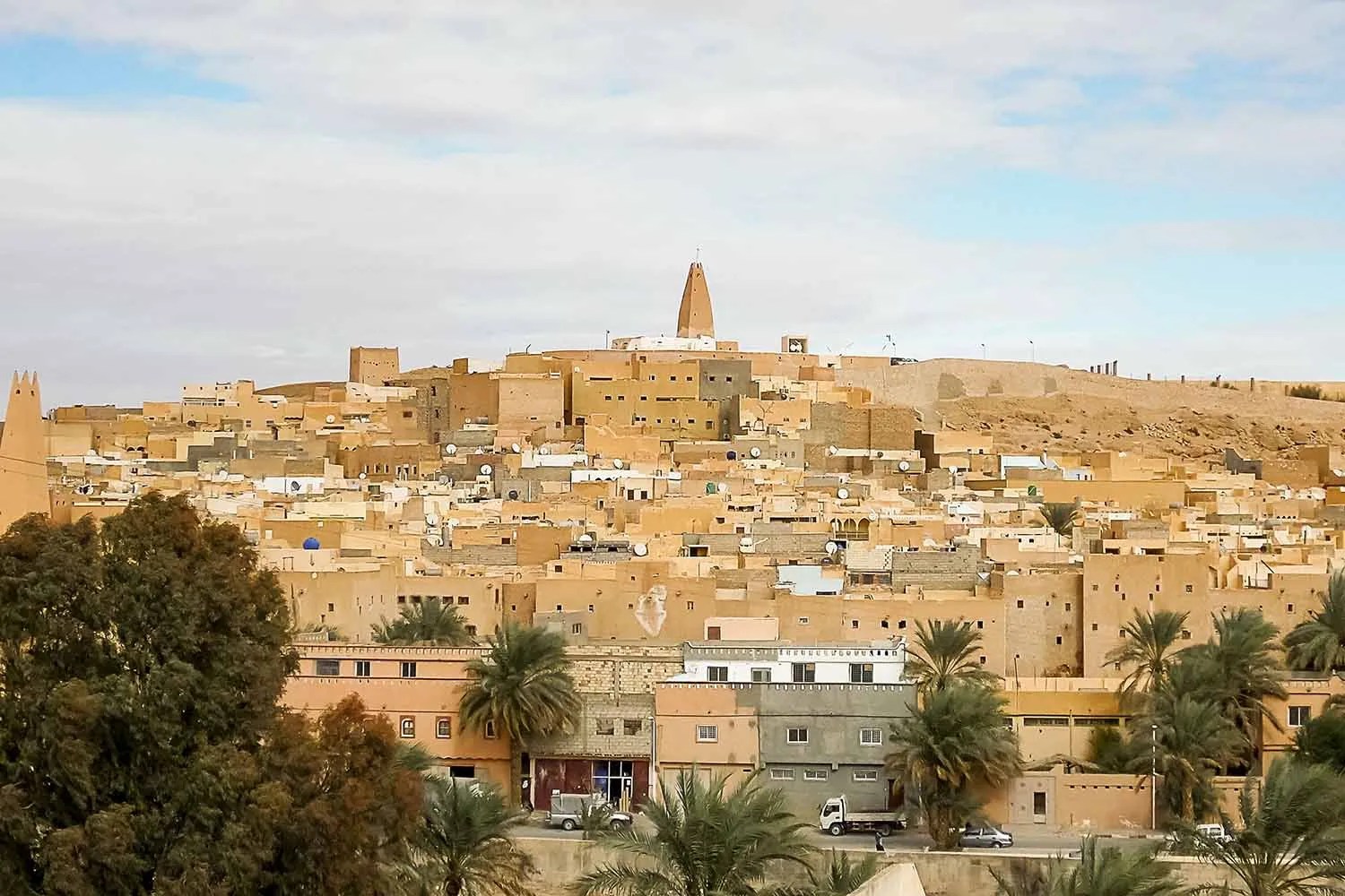
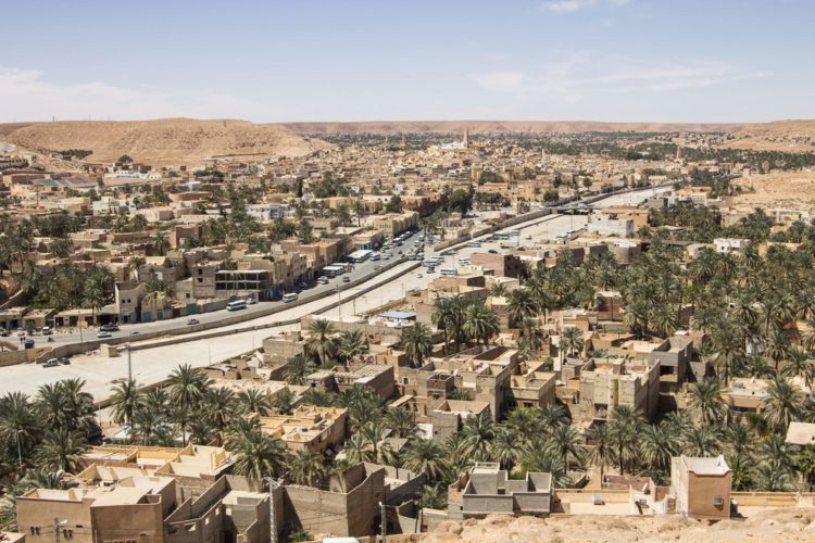
Mais ao sul, no coração do Saara, está Ghardaïa, situada no Vale do M’zab. Essa região é conhecida por sua arquitetura tradicional, cidades fortificadas e forte identidade cultural, também reconhecida pela UNESCO.
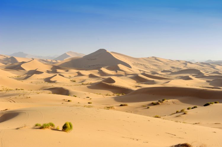
Ainda no deserto, o Deserto do Saara oferece atrações naturais impressionantes, como o planalto de Tassili n’Ajjer, no sudeste da Argélia, famoso por suas formações rochosas e arte rupestre pré-histórica.
Com essa combinação de cidades históricas, sítios arqueológicos e paisagens naturais grandiosas, a Argélia se destaca como um destino turístico rico em cultura, história e belezas naturais ainda pouco exploradas pelo turismo internacional.
Nota: as fotos onde não estão indicadas as fontes são de autoria da médica Maria Helena Vieira de Melo, amiga viajante que visitou a Argélia e nos cedeu gentilmente fotos de sua viagem, o que agradecemos.
Algerien ist das größte Land Afrikas und besticht durch eine beeindruckende Vielfalt an Landschaften, Geschichte und Kultur, die von der Mittelmeerküste bis zur riesigen Sahara reicht.
Fonte/Quelle/Source: World Guides/Tours Maps
Die Hauptstadt Algier liegt im Norden des Landes am Mittelmeer. Eine ihrer Hauptattraktionen ist die Kasbah von Algier, ein historisches Viertel, das zum UNESCO-Weltkulturerbe gehört und mit engen Gassen, osmanischen Palästen und Panoramablicken auf das Meer besticht. Algier ist das politische, wirtschaftliche und kulturelle Zentrum des Landes. Französische Kolonialbauten prägen noch heute viele Viertel.
Die Stadt beherbergt bedeutende historische Denkmäler und bietet einzigartige Stadtlandschaften. Constantine liegt spektakulär auf Felsklippen und ist von tiefen Schluchten umgeben. Die Stadt ist berühmt für ihre zahlreichen Brücken, die die Schluchten überspannen. Sie zählt zu den ältesten Städten Algeriens und blickt auf eine über 2000-jährige Geschichte zurück. Phönizier, Römer und Araber haben hier ihre Spuren hinterlassen. Constantine ist ein bedeutendes Zentrum islamischer Kultur und Bildung. Moscheen und historische Gebäude prägen das Stadtbild. Die umliegende Natur ist beeindruckend und einzigartig. Traditionen, Musik und Kunsthandwerk werden hier lebendig gepflegt.
Im Osten des Landes, nahe der Stadt Sétif, befinden sich die römischen Ruinen von Djamila.
Die Stadt ist vor allem für ihre imposanten römischen Ruinen bekannt. Die antike Stadt Cuicul gehört zum UNESCO-Weltkulturerbe. Gut erhaltene Tempel, Mosaike und Straßen zeugen von ihrer römischen Blütezeit. Die Lage in den Bergen schafft eine besondere Atmosphäre. Djamila war ein wichtiges Handels- und Kulturzentrum. Archäologische Funde geben Einblick in den Alltag der Antike. Die Ruinen zählen zu den schönsten in Nordafrika. Heute ist Djamila ein lohnendes Reiseziel für Kulturbegeisterte.
Der Ort vereint historisches Erbe und natürliche Schönheit.
Oran im Nordwesten Algeriens ist eine bedeutende Hafenstadt. Ihre Geschichte ist von spanischen und französischen Einflüssen geprägt. Die Stadt ist berühmt für ihre Musikszene, insbesondere für Rai. Moderne Alleen stehen neben Festungen und historischen Vierteln.
Oran ist ein wichtiges Wirtschafts- und Industriezentrum. Die Lage an der Küste verleiht ihr ein mediterranes Flair. Cafés, Märkte und Plätze prägen das tägliche Leben.
Die Stadt ist jung, dynamisch und vielfältig. Oran hat literarische und filmische Werke inspiriert.
Heute verkörpert sie Modernität und kulturelle Energie.
Weiter südlich, im Herzen der Sahara, liegt Ghardaïa im M’zab-Tal.
Diese Region ist bekannt für ihre traditionelle Architektur, befestigten Städte und ihre starke kulturelle Identität, die auch von der UNESCO anerkannt ist.
Mitten in der Wüste bietet die Sahara beeindruckende Naturschönheiten, wie beispielsweise das Tassili n’Ajjer-Plateau im Südosten Algeriens, das für seine Felsformationen und prähistorischen Felszeichnungen bekannt ist.
Mit dieser Kombination aus historischen Städten, archäologischen Stätten und grandiosen Naturlandschaften sticht Algerien als Reiseziel hervor, das reich an Kultur, Geschichte und Naturschönheit ist und vom internationalen Tourismus noch relativ unerschlossen ist.
Hinweis: Fotos ohne Quellenangabe stammen von Dr. Maria Helena Vieira de Melo, einer Reisefreundin, die Algerien besuchte und uns freundlicherweise Fotos von ihrer Reise zur Verfügung stellte, wofür wir uns herzlich bedanken.
Algeria is the largest country in Africa and boasts an impressive diversity of landscapes, history, and culture, ranging from the Mediterranean coast to the vast Sahara Desert.
Fonte/Quelle/Source: World Guides/Tours Maps
The capital, Algiers, is located in the north of the country, on the shores of the Mediterranean Sea. One of its main tourist attractions is the Kasbah of Algiers, an old historic quarter recognized as a UNESCO World Heritage Site, with narrow streets, Ottoman palaces, and panoramic sea views. Algiers is the political, economic, and cultural center of the country. French colonial buildings still mark many neighborhoods.
At the same time, modern skyscrapers and new urban projects are emerging.
Its port makes it an important hub for trade and transportation.
Museums, theaters, and universities enrich cultural life.
Also standing out in the northern region is Constantine, famous for its suspension bridges built over deep gorges.
The city is home to important historical monuments and offers unique urban landscapes. Constantine is spectacularly situated on rocky cliffs and surrounded by deep gorges. The city is famous for its numerous bridges that span the ravines. It is one of the oldest cities in Algeria, with over 2,000 years of history. Phoenicians, Romans, and Arabs have left their mark there. Constantine is an important center of Islamic culture and education. Mosques and historical buildings define its urban landscape. The surrounding nature is impressive and unique. Traditions, music, and crafts remain alive.
In the east of the country, near the city of Sétif, are the Roman ruins of Djamila.
It is known primarily for its impressive Roman ruins. The ancient city of Cuicul is a UNESCO World Heritage Site. Well-preserved temples, mosaics, and streets recall its Roman prosperity. The mountain location creates a special atmosphere. Djamila was an important center of trade and culture. Archaeological discoveries reveal the daily life of Antiquity. The ruins are among the most beautiful in North Africa. Today, Djamila is a relevant destination for culture lovers.
The place combines historical heritage and natural beauty.
Oran, in northwestern Algeria, is an important port city. Its history has been marked by Spanish and French influences. The city is famous for its music scene, especially Rai. Modern avenues coexist with fortresses and historic neighborhoods.
Oran is a relevant economic and industrial center. Its coastal location gives it a Mediterranean character. Cafes, markets, and squares shape daily life.
The city is young, dynamic, and diverse. Oran has inspired literary and cinematic works.
Today, it represents modernity and cultural energy.
Further south, in the heart of the Sahara, is Ghardaïa, located in the M’zab Valley.
This region is known for its traditional architecture, fortified cities, and strong cultural identity, also recognized by UNESCO.
Still in the desert, the Sahara Desert offers impressive natural attractions, such as the Tassili n’Ajjer plateau in southeastern Algeria, famous for its rock formations and prehistoric rock art.
With this combination of historic cities, archaeological sites, and magnificent natural landscapes, Algeria stands out as a tourist destination rich in culture, history, and natural beauty that is still relatively unexplored by international tourism.
Note: photos where sources are not indicated are by Dr. Maria Helena Vieira de Melo, a traveling friend who visited Algeria and kindly provided us with photos from her trip, which we appreciate.
Enviar feedback
Elas pertencem politicamente à Espanha, mas estão geograficamente mais próximas da África do que da Europa.
O arquipélago é composto por sete ilhas principais e várias ilhas menores.
Entre as ilhas mais conhecidas estão Tenerife, Gran Canaria e Lanzarote. Durante o nosso cruzeiro também visitamos Santa Cruz de La Palma e Fuerteventura.
Cada ilha possui seu próprio caráter e paisagens únicas.
O clima das Ilhas Canárias é ameno e agradável durante todo o ano.
Por esse motivo, elas são frequentemente chamadas de ilhas da eterna primavera.
A origem vulcânica molda as paisagens de todo o arquipélago.
A montanha mais alta da Espanha, o Monte Teide, está localizada em Tenerife.
Sua silhueta impressionante pode ser vista à distância.
As praias das Ilhas Canárias são muito diversas e únicas.
Existem praias de lava negra, praias de areia dourada e até praias de areia branca.
A areia de algumas praias vem do Deserto do Saara.
O mar ao redor das ilhas é claro e rico em vida marinha.
Baleias e golfinhos podem ser observados regularmente.
A culinária canária é uma mistura de influências espanholas e africanas.
Pratos típicos incluem papas arrugadas com molho mojo.
O peixe fresco desempenha um papel importante na alimentação local.
O cultivo de bananas também é muito significativo nas ilhas.
O turismo é um dos setores econômicos mais importantes da região.
Milhões de pessoas visitam as Ilhas Canárias todos os anos.
Muitos viajantes apreciam a tranquilidade e a natureza.
Outros vêm pelas atividades esportivas, como surfe ou trilhas.
As ilhas oferecem numerosas trilhas por áreas vulcânicas.
Parques nacionais protegem a flora e a fauna únicas.
A vegetação é adaptada ao clima seco.
Muitas espécies animais existem apenas nas Ilhas Canárias.
A história das ilhas remonta aos habitantes originais, os guanches.
Sua cultura ainda influencia as ilhas atualmente.
Tradições e festas desempenham um papel importante no dia a dia.
O carnaval é uma das festas mais famosas das ilhas.
O Carnaval de Santa Cruz de Tenerife é especialmente famoso no mundo todo.
A música e a dança fazem parte essencial da cultura canária.
As pessoas são consideradas abertas, simpáticas e relaxadas.
O ritmo de vida tranquilo é valorizado por muitos visitantes.
A arquitetura varia de cidades modernas a pequenas aldeias.
Casas brancas com varandas de madeira são típicas em muitos lugares.
As Ilhas Canárias combinam natureza, cultura e descanso.
Elas são um destino popular para jovens e idosos.
Nômades digitais estão cada vez mais atraídos pelas ilhas.
A boa infraestrutura facilita a vida no local.
Aeroportos conectam as ilhas à Europa e ao mundo.
Balsas permitem viagens entre as ilhas individuais.
Apesar do turismo, muitos locais preservam sua autenticidade.
As Ilhas Canárias oferecem diversidade em um espaço reduzido.
Elas encantam com seus contrastes e cores.
Cada viagem às Ilhas Canárias é única.
As ilhas deixam impressões duradouras em muitos visitantes.
Para conhecer mais sobre as Ilhas Canárias, clique aqui.
Die Kanarischen Inseln liegen im Atlantischen Ozean vor der Nordwestküste Afrikas.
Sie gehören politisch zu Spanien, sind geografisch jedoch Afrika näher als Europa.
Die Inselgruppe besteht aus sieben Hauptinseln und mehreren kleineren Inseln.
Zu den bekanntesten Inseln zählen Teneriffa, Gran Canaria und Lanzarote. Wir besuchten auf unserer Kreuzfahrt zudem Santa Cruz De La Palma und Fuerteventura.
Jede Insel besitzt ihren eigenen Charakter und landschaftliche Besonderheiten.
Das Klima der Kanarischen Inseln ist ganzjährig mild und angenehm.
Aus diesem Grund werden sie oft als die Inseln des ewigen Frühlings bezeichnet.
Vulkanische Ursprünge prägen die Landschaften der gesamten Inselgruppe.
Der höchste Berg Spaniens, der Teide, befindet sich auf Teneriffa.
Seine imposante Silhouette ist schon von weitem sichtbar.
Die Strände der Kanaren sind sehr vielfältig und einzigartig.
Es gibt schwarze Lavastrände, goldene Sandstrände und sogar weiße Strände.
Der Sand einiger Strände stammt aus der Sahara.
Das Meer rund um die Inseln ist klar und reich an Meereslebewesen.
Wale und Delfine können dort regelmäßig beobachtet werden.
Die kanarische Küche ist eine Mischung aus spanischen und afrikanischen Einflüssen.
Typische Gerichte sind Papas arrugadas mit Mojo-Soße.
Frischer Fisch spielt eine wichtige Rolle in der lokalen Ernährung.
Auch der Anbau von Bananen ist auf den Inseln sehr bedeutend.
Der Tourismus ist einer der wichtigsten Wirtschaftszweige der Region.
Jährlich besuchen Millionen Menschen die Kanarischen Inseln.
Viele Reisende schätzen die Ruhe und die Natur.
Andere kommen wegen der Sportmöglichkeiten wie Surfen oder Wandern.
Die Inseln bieten zahlreiche Wanderwege durch Vulkangebiete.
Nationalparks schützen die einzigartige Flora und Fauna.
Die Pflanzenwelt ist an das trockene Klima angepasst.
Viele Tierarten kommen nur auf den Kanarischen Inseln vor.
Die Geschichte der Inseln reicht bis zu den Ureinwohnern, den Guanchen, zurück.
Ihre Kultur beeinflusst die Inseln bis heute.
Traditionen und Feste spielen eine große Rolle im Alltag.
Der Karneval ist eines der bekanntesten Feste der Kanaren.
Besonders der Karneval in Santa Cruz de Tenerife ist weltberühmt.
Musik und Tanz sind fester Bestandteil der kanarischen Kultur.
Die Menschen gelten als offen, freundlich und entspannt.
Das langsame Lebenstempo wird von vielen Besuchern geschätzt.
Die Architektur variiert von modernen Städten bis zu kleinen Dörfern.
Weiße Häuser mit Holzbalkonen sind typisch für viele Orte.
Die Kanarischen Inseln verbinden Natur, Kultur und Erholung.
Sie sind ein beliebtes Reiseziel für Jung und Alt.
Auch digitale Nomaden zieht es zunehmend auf die Inseln.
Die gute Infrastruktur erleichtert das Leben vor Ort.
Flughäfen verbinden die Inseln mit Europa und der Welt.
Fähren ermöglichen Reisen zwischen den einzelnen Inseln.
Trotz des Tourismus bewahren viele Orte ihre Ursprünglichkeit.
Die Kanarischen Inseln bieten Vielfalt auf kleinem Raum.
Sie faszinieren durch ihre Gegensätze und Farben.
Jede Reise auf die Kanaren ist einzigartig.
Die Inseln hinterlassen bei vielen Besuchern bleibende Eindrücke.
Um mehr über die Kanarischen Inseln zu erfahren, klicken Sie hier.
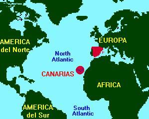
The Canary Islands are located in the Atlantic Ocean off the northwest coast of Africa.
They politically belong to Spain but are geographically closer to Africa than to Europe.
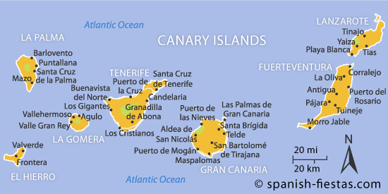
The archipelago consists of seven main islands and several smaller ones.
Among the best-known islands are Tenerife, Gran Canaria, and Lanzarote. During our cruise we also visited Santa Cruz de La Palma and Fuerteventura.
Each island has its own character and unique landscapes.
The climate of the Canary Islands is mild and pleasant all year round.
For this reason, they are often called the islands of eternal spring.
Volcanic origins shape the landscapes of the entire archipelago.
Spain’s highest mountain, Mount Teide, is located on Tenerife.
Its impressive silhouette can be seen from far away.
The beaches of the Canary Islands are very diverse and unique.
There are black lava beaches, golden sandy beaches, and even white beaches.
The sand on some beaches comes from the Sahara Desert.
The sea around the islands is clear and rich in marine life.
Whales and dolphins can be observed there regularly.
Canarian cuisine is a mix of Spanish and African influences.
Typical dishes include papas arrugadas with mojo sauce.
Fresh fish plays an important role in the local diet.
Banana cultivation is also very significant on the islands.
Tourism is one of the most important economic sectors of the region.
Millions of people visit the Canary Islands every year.
Many travelers appreciate the peace and nature.
Others come for sports activities such as surfing or hiking.
The islands offer numerous hiking trails through volcanic areas.
National parks protect the unique flora and fauna.
The plant life is adapted to the dry climate.
Many animal species exist only on the Canary Islands.
The history of the islands dates back to the indigenous Guanches.
Their culture still influences the islands today.
Traditions and festivals play a major role in daily life.
Carnival is one of the most famous celebrations on the islands.
The Carnival of Santa Cruz de Tenerife is especially world-famous.
Music and dance are an integral part of Canarian culture.
The people are considered open, friendly, and relaxed.
The slow pace of life is appreciated by many visitors.
Architecture ranges from modern cities to small villages.
White houses with wooden balconies are typical in many places.
The Canary Islands combine nature, culture, and relaxation.
They are a popular destination for young and old alike.
Digital nomads are increasingly drawn to the islands.
Good infrastructure makes life there easier.
Airports connect the islands with Europe and the world.
Ferries allow travel between the individual islands.
Despite tourism, many places preserve their authenticity.
The Canary Islands offer diversity in a small area.
They fascinate visitors with their contrasts and colors.
Every trip to the Canary Islands is unique.
The islands leave lasting impressions on many visitors.
To learn more about the Canary Islands, click here.
O Garden Park é uma das mais belas atrações naturais de Gramado, no sul do Brasil.
Inserido em uma paisagem de colinas suaves, oferece descanso para todos os sentidos.
O parque encanta os visitantes com jardins cuidadosamente planejados.
Canteiros de flores coloridas embelezam toda a área.
Cada caminhada se transforma em uma experiência especial.
O paisagismo harmonioso convida ao relaxamento.
Na primavera, o parque se transforma em um mar de flores.
No verão, a natureza revela toda a sua exuberância.
O outono traz cores quentes e românticas ao ambiente.
Mesmo no inverno, o Garden Park mantém um charme único.
Caminhos bem estruturados permitem passeios tranquilos.
Mirantes oferecem vistas panorâmicas impressionantes.
Esculturas artísticas acrescentam elegância ao espaço.
Espelhos d’água criam uma atmosfera calma e relaxante.
O parque é um verdadeiro paraíso para fotógrafos.
Muitos casais escolhem o local para casamentos inesquecíveis.
Também é ideal para passeios românticos.
Famílias encontram um destino seguro e bem cuidado.
As crianças vivenciam a natureza de forma lúdica.
O Garden Park une natureza, arte e emoção.
Ele transmite tranquilidade e alegria ao mesmo tempo.
Os jardins são mantidos com grande dedicação.
A sustentabilidade faz parte essencial do conceito.
O parque é um destaque do turismo em Gramado.
Ele reflete o charme europeu da região.
Cada visita deixa lembranças duradouras.
O Garden Park convida a relaxar e aproveitar.
Aqui é possível escapar da rotina.
O tempo parece passar mais devagar.
O Garden Park representa beleza, tranquilidade e inspiração.
Nota: Visitamos o Garden Park em dezembro de 2025. É possível chegar lá de carro de aplicativo. Para quem ama a natureza é uma ótima opção de passeio. Há um carrinho de golf à disposição dos visitantes. Se você quiser usar o carrinho, além do ingresso, deve comprar também o uso do transporte. Veja aqui mais informações sobre o Garden Park em Gramado.
Der Garden Park ist eine der schönsten Naturattraktionen in Gramado im Süden Brasiliens.
Eingebettet in eine sanfte Hügellandschaft bietet er Erholung für alle Sinne.
Der Park begeistert Besucher mit liebevoll gestalteten Gartenanlagen.
Farbenprächtige Blumenbeete prägen das gesamte Gelände.
Jeder Spaziergang wird zu einem besonderen Erlebnis.
Die harmonische Gestaltung lädt zum Abschalten ein.
Im Frühling verwandelt sich der Park in ein Blütenmeer.
Im Sommer zeigt sich die Natur von ihrer üppigsten Seite.
Der Herbst verleiht dem Park warme und romantische Farben.
Auch im Winter besitzt der Garden Park einen besonderen Charme.
Gut ausgebaute Wege ermöglichen entspannte Rundgänge.
Aussichtspunkte bieten beeindruckende Panoramablicke.
Künstlerische Skulpturen setzen elegante Akzente.
Wasseranlagen schaffen eine ruhige und entspannende Atmosphäre.
Der Park ist ein Paradies für Fotografen.
Viele Paare wählen diesen Ort für unvergessliche Hochzeiten.
Auch für romantische Spaziergänge ist er ideal.
Familien finden hier einen sicheren und gepflegten Ausflugsort.
Kinder erleben Natur auf spielerische Weise.
Der Garden Park verbindet Natur, Kunst und Emotion.
Er vermittelt Ruhe und Lebensfreude zugleich.
Die Anlagen werden mit großer Sorgfalt gepflegt.
Nachhaltigkeit ist ein wichtiger Bestandteil des Konzepts.
Der Park ist ein Highlight im touristischen Angebot Gramados.
Er spiegelt den europäischen Charme der Region wider.
Jeder Besuch hinterlässt bleibende Eindrücke.
Der Garden Park lädt zum Verweilen und Genießen ein.
Hier kann man dem Alltag entfliehen.
Die Zeit scheint langsamer zu vergehen.
Der Garden Park steht für Schönheit, Ruhe und Inspiration
Hinweis: Wir haben den Garden Park im Dezember 2025 besucht. Er ist per Mitfahr-App erreichbar. Für Naturliebhaber ist er ein tolles Ausflugsziel. Besuchern steht ein Golfwagen zur Verfügung. Wenn Sie den Wagen nutzen möchten, müssen Sie zusätzlich zur Eintrittskarte auch den Transport erwerben. Weitere Informationen zum Garden Park in Gramado finden Sie hier.
The Garden Park is one of the most beautiful natural attractions in Gramado, southern Brazil.
Nestled in a gentle hilly landscape, it offers relaxation for all senses.
The park delights visitors with carefully designed gardens.
Colorful flower beds shape the entire area.
Every walk becomes a special experience.
The harmonious design invites visitors to unwind.
In spring, the park turns into a sea of blossoms.
In summer, nature reveals its lush beauty.
Autumn gives the park warm and romantic colors.
Even in winter, the Garden Park has a unique charm.
Well-maintained paths allow for relaxing walks.
Viewpoints offer impressive panoramic views.
Artistic sculptures add elegant accents.
Water features create a calm and soothing atmosphere.
The park is a paradise for photographers.
Many couples choose this place for unforgettable weddings.
It is also ideal for romantic strolls.
Families find a safe and well-kept destination here.
Children can experience nature in a playful way.
The Garden Park combines nature, art, and emotion.
It conveys peace and joy at the same time.
The gardens are maintained with great care.
Sustainability is an important part of the concept.
The park is a highlight of Gramado’s tourism offerings.
It reflects the European charm of the region.
Every visit leaves lasting impressions.
The Garden Park invites visitors to relax and enjoy.
Here, it is easy to escape everyday life.
Time seems to slow down.
The Garden Park represents beauty, peace, and inspiration
Note: We visited Garden Park in December 2025. It’s possible to get there by ride-sharing app. For those who love nature, it’s a great outing option. There’s a golf cart available for visitors. If you want to use the cart, in addition to the entrance ticket, you must also purchase transportation. See here for more information about Garden Park in Gramado.
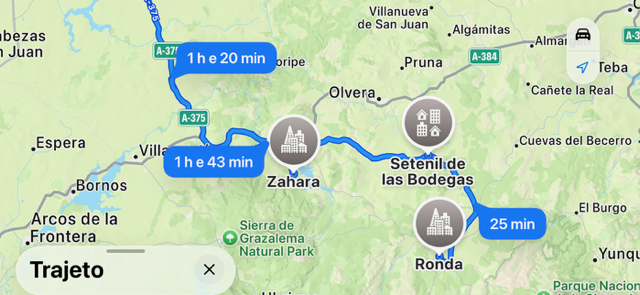
Um passeio de um dia desde Sevilha até Zahara de la Sierra, Setenil de las Bodegas e Ronda combina natureza, história e o encanto andaluz de forma memorável. Logo pela manhã, parte-se de Sevilha atravessando colinas suaves e extensos olivais em direção às aldeias brancas.
Fonte/Quelle/Google MapsFonte/Quelle/Source: Google Maps
Zahara de la Sierra recebe os visitantes com um reservatório de águas verde-esmeralda, ruas estreitas e um castelo no topo da colina, de onde se tem uma vista ampla do Parque Natural da Sierra de Grazalema.
Após uma breve caminhada e uma pausa, a viagem continua até Setenil de las Bodegas, uma das localidades mais singulares da Andaluzia. Ali, as casas estão construídas sob enormes saliências rochosas que oferecem sombra fresca no verão. Passear pelas ruas e almoçar em um bar escavado na rocha é um dos pontos altos do dia.
À tarde, o percurso segue para Ronda, situada de forma dramática sobre um planalto rochoso acima do profundo desfiladeiro de El Tajo. A famosa Puente Nuevo liga a cidade antiga à moderna e proporciona vistas inesquecíveis. Em Ronda, há tempo para visitar a histórica Praça de Touros, explorar o centro antigo e apreciar um café com vista. Ao anoitecer, o retorno a Sevilha acontece com a sensação de ter conhecido três faces muito diferentes da Andaluzia em apenas um dia.
Obs.: Este tipo de excursão está disponível nos aplicativos que oferecem excursões na Internet.
Ein Eintages-Ausflug von Sevilla nach Zahara de la Sierra, Setenil de las Bodegas und Ronda verbindet Natur, Geschichte und andalusischen Charme auf eindrucksvolle Weise. Früh am Morgen verlässt man Sevilla und fährt durch sanfte Hügel und Olivenhaine in Richtung der weißen Dörfer.
Fonte/Quelle/Google MapsFonte/Quelle/Source: Google Maps
Zahara de la Sierra empfängt Besucher mit einem smaragdgrünen Stausee, engen Gassen und einer Burg, von der aus sich ein weiter Blick über den Naturpark Sierra de Grazalema öffnet.
Nach einem kurzen Spaziergang und einer Pause geht es weiter nach Setenil de las Bodegas, einem der ungewöhnlichsten Orte Andalusiens. Hier schmiegen sich die Häuser spektakulär unter riesige Felsüberhänge, die im Sommer kühlen Schatten spenden. Ein Bummel durch die Straßen und ein Mittagessen in einer der Höhlenbars gehören zu den Höhepunkten des Tages.
Am Nachmittag führt die Route nach Ronda, dramatisch auf einem Felsplateau über der tiefen Schlucht El Tajo gelegen. Die berühmte Puente Nuevo verbindet die Alt- und Neustadt und bietet unvergessliche Ausblicke. In Ronda bleibt Zeit für die historische Stierkampfarena, die Altstadt mit ihren Palästen und einen entspannten Kaffee mit Aussicht. Am Abend kehrt man mit vielen Eindrücken, Fotos und dem Gefühl zurück, drei sehr unterschiedliche Gesichter Andalusiens an nur einem Tag erlebt zu haben.
Hinweis: Diese Art von Ausflug ist über Apps verfügbar, die Online-Touren anbieten.
A one-day trip from Seville to Zahara de la Sierra, Setenil de las Bodegas, and Ronda beautifully combines nature, history, and Andalusian charm. Early in the morning, travelers leave Seville and pass rolling hills and olive groves toward the famous white villages.
Fonte/Quelle/Google MapsFonte/Quelle/Source: Google Maps
Zahara de la Sierra welcomes visitors with an emerald-green reservoir, narrow streets, and a hilltop castle offering wide views over the Sierra de Grazalema Natural Park. After a short walk and a break, the journey continues to Setenil de las Bodegas, one of Andalusia’s most unusual towns. Here, houses are built directly beneath massive rock overhangs that provide cool shade in summer. Strolling through the streets and enjoying lunch in a cave restaurant is a highlight of the day. In the afternoon, the route leads to Ronda, dramatically set on a rocky plateau above the deep El Tajo gorge. The famous Puente Nuevo connects the old and new towns and offers unforgettable views. In Ronda, there is time to visit the historic bullring, explore the old town with its palaces, and relax with a coffee overlooking the landscape. In the evening, travelers return to Seville with lasting memories of experiencing three very different faces of Andalusia in a single day.
Note: This type of excursion is available on apps that offer online tours.
A ilha da Madeira, muitas vezes chamada de “Pérola do Atlântico”, fica cerca de 1.000 quilômetros a sudoeste de Portugal.
É famosa pelo clima ameno, que oferece temperaturas agradáveis durante todo o ano. As falésias dramáticas e os vales profundos moldam a paisagem única da ilha.
Particularmente impressionantes são as muitas levadas,
canais de irrigação artificiais que atravessam montanhas e florestas. Caminhantes do mundo inteiro visitam a Madeira para explorar estas trilhas fascinantes.
A vegetação exuberante, incluindo as florestas de loureiros, faz parte do Patrimônio Natural da UNESCO.
A capital, Funchal, encanta com seus edifícios históricos e mercados animados. O Mercado dos Lavradores é um local colorido repleto de frutas e flores exóticas. A catedral Sé, do século XV, é outra atração.
Madeira também é famosa pelo seu vinho tradicional, apreciado mundialmente. Muitos visitantes exploram as antigas adegas para provar este vinho especial.
O jardim botânico do Funchal oferece uma vista magnífica sobre a cidade, com plantas de várias zonas climáticas.
Viajantes aventureiros visitam o Cabo Girão, uma das falésias mais altas da Europa, com uma plataforma de vidro que proporciona vistas espetaculares.
Embora as praias sejam principalmente de origem vulcânica, a costa é convidativa, especialmente as piscinas naturais de Porto Moniz. As aldeias de montanha revelam arquitetura tradicional, com casas brancas e telhados vermelhos, e Santana é conhecida por suas casas triangulares de colmo.
Muitas vezes, a névoa envolve as florestas, criando um ambiente místico. O Pico Ruivo, com 1.862 metros, é o ponto mais alto da ilha e um dos trilhos mais belos. A gastronomia local oferece peixe fresco, espetadas e o famoso pão bolo do caco.
A tradicional bebida Poncha é indispensável. Festivais como a Festa da Flor atraem muitos visitantes, transformando as ruas do Funchal num mar de flores. O Réveillon é outro destaque, com um dos maiores fogos de artifício da Europa. Madeira combina natureza, cultura e hospitalidade de forma única, deixando cada visitante profundamente impressão.
Obs.: o voo entre Lisboa e Funchal, capital da Ilha da Madeira, é de 1 hora e 45 minutos. O aeroporto de Funchal tem o nome de Cristiano Ronaldo, que nasceu lá.
Die Insel Madeira, oft als „Perle des Atlantiks“ bezeichnet, liegt rund 1.000 Kilometer südwestlich von Portugal.
Sie ist berühmt für ihr mildes Klima, das das ganze Jahr über angenehme Temperaturen bietet und Besucher aus aller Welt anzieht. Die dramatischen Klippen und tief eingeschnittenen Täler prägen das charakteristische Landschaftsbild, das Madeira so einzigartig macht. Besonders beeindruckend sind die zahlreichen Levadas,
künstliche Wasserläufe, die sich durch Berge, Schluchten und üppige Wälder ziehen. Entlang dieser Wege erleben Wanderer spektakuläre Ausblicke und eine nahezu unberührte Natur. Die Lorbeerwälder Madeiras zählen zum UNESCO-Weltnaturerbe und vermitteln das Gefühl eines urzeitlichen Paradieses.
Die Hauptstadt Funchal begeistert mit historischen Gebäuden, lebhaften Märkten und einer charmanten Altstadt. Der Mercado dos Lavradores ist ein farbenfroher Treffpunkt voller exotischer Früchte, Blumen und traditioneller Produkte. Auch die Kathedrale Sé aus dem 15. Jahrhundert gehört zu den kulturellen Höhepunkten der Insel. Madeira ist zudem weltberühmt für seinen aromatischen Wein, der in alten Weinkellereien verkostet werden kann. Ein Besuch im botanischen Garten von Funchal bietet großartige Ausblicke über die Stadt und eine Vielfalt an Pflanzen aus unterschiedlichen Klimazonen.
Abenteuerlustige zieht es zum spektakulären Cabo Girão, einer der höchsten Klippen Europas, deren gläserne Aussichtsplattform atemberaubende Tiefblicke ermöglicht. Die Küsten Madeiras laden trotz ihrer meist vulkanischen Strände zum Entspannen ein, besonders die natürlichen Meeresschwimmbecken von Porto Moniz sind ein beliebtes Ziel. In den Bergdörfern beeindrucken traditionelle Häuser mit weißen Wänden und roten Dächern, während Santana mit seinen strohbedeckten Dreieckshäusern ein besonderes Highlight darstellt. Nebel, der durch die Wälder zieht, verleiht dem Inselinneren häufig eine mystische Stimmung. Der Pico Ruivo, mit 1.862 Metern der höchste Berg Madeiras, bietet Wanderern unvergessliche Erlebnisse. Die lokale Küche verwöhnt mit frischem Fisch, Espetada-Spießen und dem berühmten Bolo do Caco. Dazu passt hervorragend die traditionelle Poncha, ein Getränk aus Zuckerrohrschnaps. Festivals wie das Blumenfest verwandeln Funchal jedes Jahr in ein duftendes Blütenmeer. Auch das spektakuläre Silvesterfeuerwerk gehört zu den Höhepunkten der Insel. Madeira vereint Natur, Kultur, Gastfreundschaft und Vielfalt auf beeindruckende Weise – ein Reiseziel, das nachhaltig in Erinnerung bleibt.
Hinweis: Der Flug zwischen Lissabon und Funchal, der Hauptstadt der Insel Madeira, dauert 1 Stunde und 45 Minuten. Der Flughafen Funchal ist nach Cristiano Ronaldo benannt, der dort geboren wurde.
Madeira, oftencalledthe “Pearl oftheAtlantic,” lies about 1,000 kilometerssouthwestof Portugal.
Itisfamousforits mild climate, whichofferspleasanttemperatures all yearround. Dramaticcliffs and deeplycarvedvalleysshapetheisland’suniquelandscape.
Particularlyimpressivearethemanylevadas, man-made
irrigationchannelsthatrunthroughmountains and forests. Hikersfrom all overtheworldcometo Madeira toexperiencebreathtakingtoursalongtheseroutes. The lushvegetation, includinglaurelforests, ispartofthe UNESCO World Natural Heritage. The capital Funchal impresseswith its historicbuildingsandlivelymarkets. The Mercado dos Lavradores is a colorfulplace full ofexoticfruitsandflowers. The 15th-century Sé Cathedralisanotherhighlight. Madeira isalsofamous for its traditionalwine, appreciatedworldwide. Manyvisitors tour theoldwinecellarstotastethisspecial drink. The botanicalgardenof Funchal offers a splendidview over thecityand hosts plantsfromvariousclimate zones. Adventuroustravelersvisit Cabo Girão, oneofEurope’shighestcliffs, featuring a glassplatformwithstunningviews. AlthoughMadeira’sbeaches are mostlyvolcanic, thecoast invites relaxation, especiallythe natural sea pools of Porto Moniz. The mountain villagesoffertraditionalarchitecture, withwhitehousesandredroofs, while Santana isknown for its thatched triangular homes. Mist oftendriftsthroughtheisland’sforests, creating a mysticalatmosphere. Pico Ruivo, at 1,862 meters, istheisland’shighestpeak and a favoritehikingdestination. The local cuisine features freshfish, espetadaskewers, andthefamousbolo do cacobread. The traditional drink Ponchaisnottobemissed. Festivals like theFlower Festival attractmanyvisitorseachyear, turningFunchal’sstreetsinto a sea ofblossoms. New Year’s Eve isanother highlight, withoneofEurope’slargestfireworksshows. Madeira beautifullycombines nature, culture, andhospitality, leavingeveryvisitordeeplyimpressed.
Note: The flight between Lisbon and Funchal, the capital of Madeira Island, takes 1 hour and 45 minutes. Funchal Airport is named after Cristiano Ronaldo, who was born there.
Apresentar lugares visitados ao redor do mundo e proporcionar um intercâmbio de informações com nossos visitantes./Display places visited around the world and provide an exchange of information with our visitors./Weltweit besuchte Orte vorstellen und einen Informationsaustausch mit unseren Besuchern anregen.

 A cidade de Colonia del Sacramento está localizada no sudoeste do Uruguay às margens do Río de la Plata, em frente a Buenos Aires.
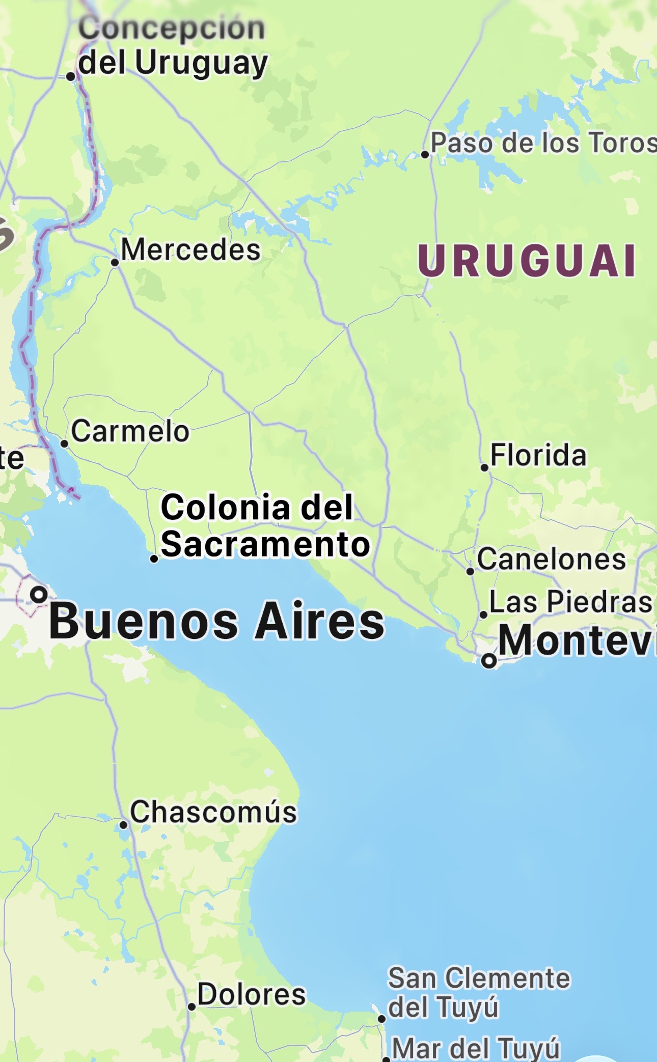
 Die Stadt Colonia del Sacramento liegt im Südwesten von Uruguay direkt am Río de la Plata gegenüber von Buenos Aires.
 The city of Colonia del Sacramento is located in the southwest of Uruguay on the Río de la Plata, directly across from Buenos Aires. It is one of the oldest cities in the country and was founded in 1680 by the Portuguese. Because of its strategic location, the city was disputed for a long time between Portugal and Spain. This turbulent history left behind a unique architectural heritage that is still well preserved today. The historic quarter, known as Barrio Histórico, is especially famous for its cobblestone streets, low houses, and old city walls. The old town has been a UNESCO World Heritage Site since 1995 and attracts many visitors from all over the world every year. Walking through the narrow streets feels like traveling back to the colonial era. Many buildings date from the 17th and 18th centuries and show a mix of Portuguese and Spanish architectural styles. The city’s landmark is the old lighthouse, from which there is a beautiful view over the rooftops and the Río de la Plata. The Matriz Church, one of the oldest churches in Uruguay, is also an important historical monument. Colonia del Sacramento is not only a place of history but also of peace and relaxation. Small cafés, restaurants, and craft shops invite visitors to stay and enjoy the atmosphere. In the evening, the city becomes especially romantic when the sun sets over the river. Many visitors come on a day trip from Buenos Aires by ferry, as the crossing takes only about one hour. Despite its proximity to the big city, Colonia has preserved its calm and charming character. The city is a popular destination for culture lovers, photographers, and travelers who want to experience authentic South America. The surrounding area with its beaches and rural landscapes also offers beautiful excursions. Colonia del Sacramento is considered one of the most beautiful cities in Uruguay and a place where history remains alive.