Cânion do Xingó, preciosidade nordestina/Der Xingó-Canyon, eine Kostbarkeit im Nordosten/The Xingó Canyon, a treasure in the northeast

Quando estávamos elaborando nosso livro 66 x Brasil realizamos muitas viagens para captar imagens para essa publicação. Dentre os lugares que visitamos e recomendamos o passeio é a visita ao Cânion do Xingó.

Esse cânion está localizado na cidade de Canindé de São Francisco distante em torno de 200 km de Aracaju.

Fonte/Quelle/Source: Google Maps

Primeiro, vale ressaltar que esse cânion surgiu devido ao represamento das águas do Rio São Francisco para a construção da Usina Hidrelétrica de Xingó em 1994, situada entre os estados de Alagoas e Sergipe.

O ponto de partida para se realizar o passeio para visitar esse cânion sai do Karranca’s Bar e Restaurante localizado nas margens do rio São Francisco, localizado na cidade de Canindé do São Francisco, no estado do Sergipe. Há muitos barcos e catamarãs ancorados nas proximidades que realizam esse tour. O restaurante tem uma boa estrutura.

Carranca

O passeio dura em torno de três horas, uma hora navegando, outra hora de parada para banho e outra hora para voltar.

Depois de uma meia hora de navegação a partir do ponto de embarque já é possível apreciar a paisagem com atrativos mais interessantes como o Morro dos Macacos, a Pedra do Gavião, dentre outros.

Na parte mais bela do percurso existe a opção de trocar de barco, usar um barco pequeno e navegar por pequena rota entre os paredões de pedra. É quando você consegue chegar bem perto da Gruta do Talhado. Na época custava em torno de R$ 10,00 (dez reais).

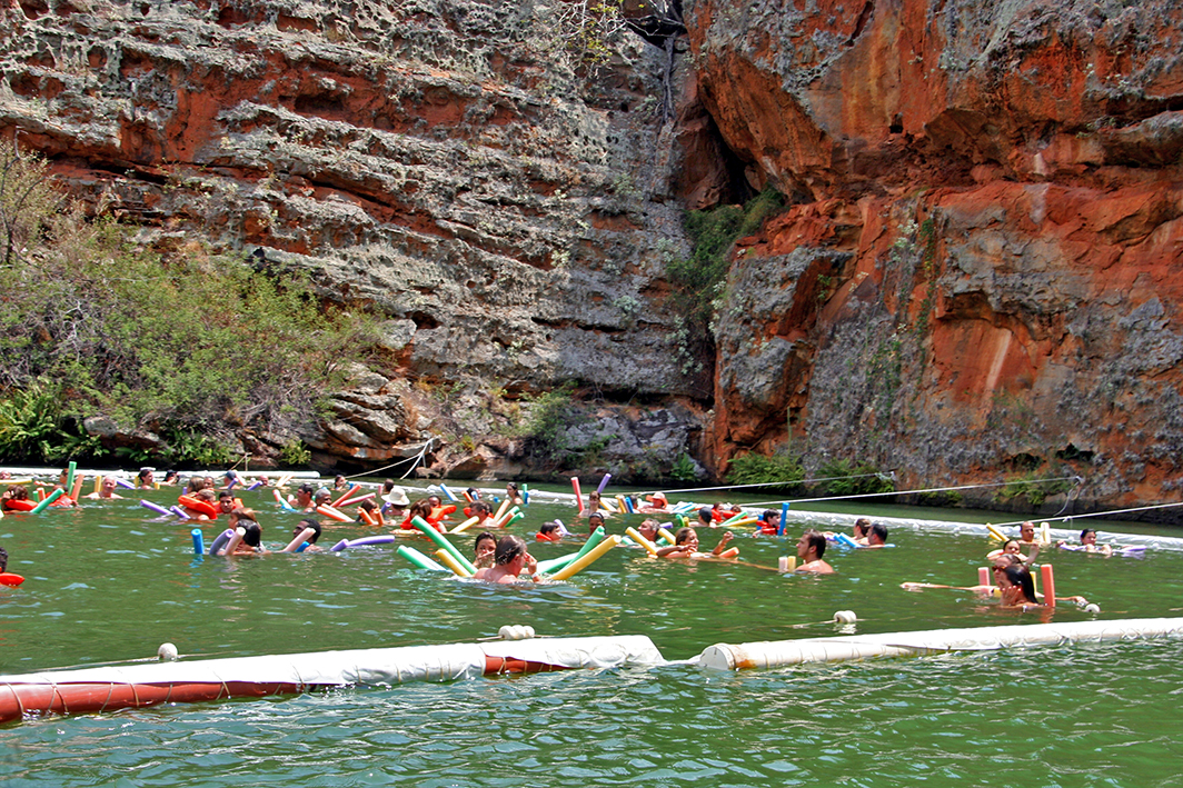
Há também uma parada para banho numa parte protegida do rio (tem uma rede que delimita a área para banho) e quase todos que estavam no barco mergulharam nas águas quentes para se refrescarem.

O cenário é realmente esplendoroso! Algumas cenas da novela da rede Globo chamada Cordel Encantado foi foram filmadas nessa área.

Um aspecto que deve ser destacado é que há música alta no barco, tem muita gente e tem também um guia falante que vai explicando o percurso. Essas características estavam presentes antes da pandemia, atualmente acredito que os organizadores diminuíram o número de passageiros nos barcos.

A realização desse passeio é recomendada para quem gosta de apreciar belos cenários brasileiros. Pernoitamos em Canindé de São Francisco, não recomendamos fazer um bate-volta saindo de Aracaju. Se você for visitar essa região vale a pena também conhecer Piranhas, que está localizada a apenas 20 km de Canindé de São Francisco.

Observação: se você quiser continuar “viajando” com o nosso blog, clique no botão “seguir” localizado no canto inferior direito dessa página. Você também pode “viajar” pelo Brasil conhecendo nosso  livro impresso  66 x Brasil e sua versão digital 66 Belezas do Brasil.

Der Xingó-Canyon, eine Kostbarkeit im Nordosten

Als wir unser Buch 66 x Brasilien vorbereiteten, unternahmen wir viele Reisen, um Bilder für diese Veröffentlichung aufzunehmen. Unter den Orten, die wir besuchten und die wir empfehlen, befindet sich auch der Xingó-Canyon.

Diese Schlucht befindet sich bei der Stadt Canindé de São Francisco, etwa 200 km von Aracaju entfernt.

Fonte/Quelle/Source: Google Maps

Zunächst ist zu erwähnen, daβ diese Schlucht durch die Stauung des Wassers des Flusses São Francisco für den Bau des Wasserkraftwerks Xingó im Jahr 1994 zwischen den Bundesstaaten Alagoas und Sergipe entstanden ist.

Der Ausgangspunkt für die Tour zu diesem Canyon ist die Karranca’s Bar und das Restaurant am Ufer des Flusses São Francisco in der Stadt Canindé do São Francisco im Bundesstaat Sergipe. In der Nähe ankern viele Boote und Katamarane, die diese Tour durchführen. Das Restaurant offeriert eine gute Service-Struktur.

Carranca

Die Tour dauert ungefähr drei Stunden, eine Stunde Bootsfahrt, eine weitere Stunde für ein tolles Bad und eine weitere Stunde für die Rückkehr.

Nach einer halben Stunde Navigation vom Einschiffungspunkt aus ist es bereits möglich, die Landschaft mit interessanteren Attraktionen wie Morro dos Macacos und Pedra do Gavião zu genießen.

Am schönsten Teil der Route besteht die Möglichkeit, vom Schiff auf ein kleines Boot zu wechseln und eine kurze Fahrt zwischen den steilen Canyonwänden zu navigieren. Dann können Sie der Gruta do Talhado sehr nahekommen. Zu unserer Zeit kostete dies rund 10 R$ (zehn Reais).

Es existiert auch eine Haltestelle zum Baden in einem geschützten Teil des Flusses (es gibt hierzu ein Netz, das den Badebereich begrenzt) und fast jeder, der auf dem Boot war, tauchte ins warme Wasser ein, um sich abzukühlen.

Die Landschaft ist wirklich großartig! In diesem Bereich wurden einige Szenen der Globo Seifenoper namens Cordel Encantado gedreht.

Ein Aspekt, der hervorgehoben werden sollte, ist, dass es auf dem sehr vollen Schiff auch sehr laute Musik gab, aber auch einen Reiseführer mit Informationen. Ich nehme an, dass nun zu Pandemie-Zeiten die Zahl der Passagiere sich deutlich verringert hat.

Diese Tour empfehlen wir denjenigen, die diese wunderschöne brasilianische Landschaft genießen möchten. Wir übernachteten in Canindé de São Francisco, wir empfehlen nicht den Ein-Tages-Ausflug von Aracaju aus.

Falls Sie diese Region besuchen, lohnt sich auch ein Besuch in Piranhas, das nur 20 km von Canindé de São Francisco entfernt liegt.

Hinweis: Falls Sie unserem  Blog folgen wollen, dann klicken Sie unten rechts einfach auf “Weiter”, Sie werden dann zukünftig automatisch informiert. Sie können auch durch Brasilien reisen und unser Buch 66 SEHENSWÜRDIGKEITEN IN BRASILIEN  kennenlernen und 66 x Brazil – A Mosaic of Beauties.

The Xingó Canyon, a treasure in the northeast

As we were preparing our book 66 x Brazil we traveled extensively to take pictures for this publication. Among the places we visited and recommend is the Xingó Canyon.

This gorge is located near the town of Canindé de São Francisco, about 200 km from Aracaju.

Fonte/Quelle/Source: Google Maps

First of all, it should be mentioned that this gorge was created by the damming of the water of the São Francisco River for the construction of the Xingó hydropower plant in 1994 between the states of Alagoas and Sergipe.

The starting point for the tour to this canyon is Karranca’s Bar and Restaurant on the banks of the São Francisco River in the city of Canindé do São Francisco in the state of Sergipe. Many boats and catamarans that operate this tour anchor nearby. The restaurant offers a good service structure.

Carranca

The tour takes around three hours, an hour boat ride, another hour for a great swim, and another hour to return.

After half an hour of navigation from the embarkation point, it is already possible to enjoy the scenery with more interesting attractions such as Morro dos Macacos and Pedra do Gavião.

On the most beautiful part of the route, there is the option of switching from the ship to a small boat and navigating a short drive between the steep canyon walls. Then you can get very close to the Gruta do Talhado. In our time this cost around R $ 10 (ten reais).

There is also a stop for bathing in a protected part of the river (there is a net that delimits the bathing area) and almost everyone who was on the boat took a dip in the warm water to cool off.

The landscape is really great! Some scenes from the Globo soap opera called Cordel Encantado were filmed in this area.

One aspect that should be emphasized is that there was also very loud music on the very crowded ship, but also a guide with information. I assume that the number of passengers has now decreased significantly during pandemic times.

We recommend this tour to those who want to enjoy this beautiful Brazilian landscape. We stayed in Canindé de São Francisco, we don’t recommend the one day trip from Aracaju.

If you visit this region, you can also visit Piranhas, which is only 20 km from Canindé de São Francisco.

Note: If you want to follow our “Travels” on the blog, simply click on “Seguir” in the lower right corner, you will be then automatically informed in the future. You can continue traveling with us with our book Brazil´s 66 Beautiful Sites and 66 x Brazil – A Mosaic of Beauties.  


ESTAÇÕES DE UMA VIAGEM MARÍTIMA INESQUECÍVEL (PARTE 2)/STATIONEN EINER UNVERGESSLICHEN SEEREISE (TEIL 2)/STATIONS OF AN UNFORGETTABLE SEA VOYAGE (PART 2)

Do Cabo Horn a Valparaíso

Estação 1: Ushuaia / Argentina

Depois da bem sucedida e inesquecível circunavegação do “Cabo Horn”, chegamos no dia seguinte a Ushuaia, a cidade mais austral de nosso planeta.

Ushuaia é também a cidade mais austral da Argentina e

Capital da província de Tierra del Fuego, na margem norte do Canal de Beagle,

a hidrovia  natural que conecta o Atlântico Sul com o Pacífico. Aqui no extremo sul da América do Sul, chegamos à conclusão de que também gostaríamos de visitar o Alasca. Ushuaia fica a 3.200 km de Buenos Aires e é considerado o último posto avançado antes da Antártica.

 Você pode encontrar mais informações sobre “Ushuaia” e Tierra del Fuego em nosso blog.

Nossa curta viagem marítima nos trouxe então para nossa próxima parada durante a noite.

Estação 2: Punta Arenas / Chile

A cidade portuária chilena de Punta Arenas está localizada no ponto mais meridional do continente sul-americano, no famoso Estreito de Magalhães, que conecta o Oceano Atlântico com o Oceano Pacífico.

Tínhamos planejado originalmente uma viagem de um dia ao mundialmente famoso Parque Nacional Torre del Paine saindo de Punta Arenas, mas o voo foi cancelado devido ao mau tempo. Por isso, fomos forçados a visitar este parque em outra viagem.

Aproveitamos o dia em Punta Arenas com passeios e visitas à  mirantes

da cidade com suas casas coloridas com  jardins frontais cheios de flores de diversas cores  e ao Estreito de Magalhães.  Você pode ler mais sobre isso aqui.

No dia seguinte, passamos pelo Glaciar Amalia, nossa parada 3 nesta parte da viagem. Esta não é uma verdadeira parada em um porto, mas uma parte da viagem chamada  “cruzeiro panorâmico”, cuja rota passa bem   próximo ao Glaciar Amalia

e depois seguimos através de belas paisagens de fiorde chileno com vista para os Andes do sul do Chile, nesse momento, o

 pôr-do-sol banhava as paisagens com uma luz de sonho, de conto de fadas, espetacular … !!!

Depois de um dia no mar com todas as comodidades de um hotel flutuante, chegamos a Puerto Montt.

Estação 4: Puerto Montt / Chile

Puerto Montt fica a 1.055 quilômetros de Santiago e tem uma população de aproximadamente 200.000 habitantes. A cidade e sua economia são baseadas principalmente no turismo e na exportação de salmão.

Puerto Montt é a porta de entrada para viagens ao Rio Petrohue e à Região dos Lagos. Você pode desfrutar de paisagens verdes exuberantes e experimentar o Lago Esmeraldo com suas águas verdes brilhantes,

em que o famoso vulcão Osorno está localizado. No parque, você pode passear e admirar cachoeiras imponentes. O vulcão Osorno é o destaque da beleza cênica e conhecido como o “Fuji da América do Sul”.

Depois do último belo dia em alto mar no Pacífico, que gostamos muito,

finalmente chegamos ao porto de Valparaíso, ficamos muito felizes com todas as impressões grandiosas e inesquecíveis desta viagem tão especial.

De Santiago do Chile, voltamos à nossa pátria em um impressionante vôo sobre os Andes.

Você pode encontrar mais informações sobre Santiago aqui.

Observação: se você quiser continuar “viajando” com o nosso blog, clique no botão “seguir” localizado no canto inferior direito dessa página. Você também pode “viajar” pelo Brasil conhecendo nosso  livro impresso  66 x Brasil e sua versão digital 66 Belezas do Brasil.

STATIONEN EINER UNVERGESSLICHEN SEEREISE (TEIL 2)

 Von Kap Horn nach Valparaiso

 Station 1: Ushuaia /Argentinien

Nach der erfolgreichen und unvergesslichen Umsegelung von „Kap Horn“ erreichten wir am nächsten Tag Ushuaia, die südlichst gelegene Stadt unseres Planeten.

Ushuaia ist auch die südlichste Stadt Argentiniens und

Hauptstadt der Provinz Feuerland am Nordufer des Beagle- Kanals,

eben diese natürliche Wasserstraβe, die den Südatlantik mit dem Pazifik verbindet.

Hier ganz im Süden Südamerikas fassten wir den Schluss, auch einmal Alaska besuchen zu wollen.

Ushuaia ist 3.200 km von Buenos Aires entfernt und gilt als letzter Vorposten vor der Antarktis.

Mehr Informationen zu „Ushuaia“ und Feuerland finden Sie in unseren Blogbeiträgen hier und hier.

Unsere kurzweilige Seereise brachte uns dann über Nacht zu unserem nächsten Haltepunkt.

Station 2: Punta Arenas /Chile

Die chilenische Hafenstadt Punta Arenas liegt am südlichsten Punkt des südamerikanischen  Festlandes an der berühmten Magellanstraβe, die den Atlantischen Ozean mit dem Pazifischen Ozean verbindet.

Ursprünglich hatten wir hier in Punta Arenas einen Tagesausflug in den weltberühmten Torre del Paine Nationalpark geplant, aber wegen des sehr schlechten Wetters wurde der Flug dorthin abgesagt. Also sahen wir uns gezwungen, diesen Park auf einer anderen Reise zu besuchen.Mehr hierzu hier.

Wir genossen den Tag in Punta Arenas mit Spaziergängen und schönen Aussichtspunkten

auf die Stadt mit ihren bunten Häusern, Vorgärten voller bunter Blumen und die Magellanstraβe. Mehr hier.

Am nächsten Tag passierten wir den Amalia Gletscher, unsere Station 3 auf diesem Teil der Reise, es handelt sich hierbei nicht um einen realen Stopp in einem Hafen, sondern um ein   Dahingleiten (szenische Kreuzfahrt), „scenic cruising“  zunächst nahe am Gletscher Amalia selbst

und dann später durch wunderschöne chilenische Fjordlandschaften mit Blick auf die Anden Südchiles, der

Sonnenuntergang selbst tauchte dann die Landschaften in ein traumhaftes, märchenhaftes Licht, spektakulär…!!!

Nach einem Tag auf See mit all den Annehmlichkeiten eines schwimmenden Hotels erreichten wir dann Puerto Montt.

Station 4: Puerto Montt /Chile

Puerto Montt ist 1.055 Kilometer von Santiago entfernt und hat eine Bevölkerung von ungefähr 200.000 Einwohnern. Die Stadt   und seine Wirtschaft basieren hauptsächlich auf Tourismus und dem Export von Lachs.

Puerto Montt ist das Tor für Ausflüge zum Rio Petrohue und den Seendistrikt. Sie können üppige grüne Landschaften genießen und den See Esmeraldo mit seinem hellen grünen Wassern erleben,

an welchen der berühmte Vulkan Osorno gelegen ist. Im Park können Sie umherwandern und imposante Wasserfälle bewundern. Der Vulkan Osorno ist das Highlight der landschaftlichen Schönheit und bekannt als der “Fuji Südamerikas.”

Mehr hier.

Nach einem letzten schönen Tag auf hoher See im Pazifik, den wir sichtlich genossen

erreichten wir schlieβlich den Hafen von Valparaiso, wir beide sehr glücklich über all die grandiosen und unvergesslichen Eindrücke dieser so speziellen Reise.

Von Santiago de Chile ging es dann in einem immer wieder beeindruckenden Flug über die Anden zurück in Richtung Heimat.

Mehr Informationen über Santiago finden Sie hier.

Hinweis: Falls Sie unserem  Blog folgen wollen, dann klicken Sie unten rechts einfach auf “Weiter”, Sie werden dann zukünftig automatisch informiert. Sie können auch durch Brasilien reisen und unser Buch 66 SEHENSWÜRDIGKEITEN IN BRASILIEN  kennenlernen und 66 x Brazil – A Mosaic of Beauties.

STATIONS OF AN UNFORGETTABLE SEA VOYAGE (PART 2)

From Cape Horn to Valparaiso

Station 1: Ushuaia / Argentina

After the successful and unforgettable circumnavigation of “Cape Horn” we reached Ushuaia, the southernmost city on our planet, the next day.

Ushuaia is also the southernmost city in Argentina and

Capital of the province of Tierra del Fuego on the north bank of the Beagle Channel,

the very natural waterway that connects the South Atlantic with the Pacific.

Here in the very south of South America, we came to the conclusion that we would also like to visit Alaska.

Ushuaia is 3,200 km from Buenos Aires and is considered the last outpost before Antarctica.

You can find more information about “Ushuaia” and Tierra del Fuego in our blog posts here and here.

Our short sea voyage then brought us to our next stop overnight.

Station 2: Punta Arenas / Chile

The Chilean port city of Punta Arenas is located at the southernmost point of the South American mainland on the famous Strait of Magellan, which connects the Atlantic Ocean with the Pacific Ocean.

We had originally planned a day trip to the world-famous Torre del Paine National Park here in Punta Arenas, but the flight there was canceled due to the very bad weather. So we were forced to visit this park on another trip.

More on this: https://imagenseviagens.com.br/?s=torre+del+paine

We enjoyed the day in Punta Arenas with walks and beautiful viewpoints

of the city with its colorful houses, front gardens full of colorful flowers and the Strait of Magellan.                                                                    More on this:                      https://imagenseviagens.com.br/2017/08/04/punta-arenas-capital-da-regiao-de-magalhaes/

The next day we passed the Amalia Glacier, our stop 3 on this part of the journey, this is not a real stop in a port, but a “scenic cruising” initially close to the Amalia glacier itself

and then later through beautiful Chilean fjord landscapes with a view of the Andes of southern Chile, the

Sunset itself then bathed the landscapes in a dreamlike, fairytale light, spectacular…!!!

After a day at sea with all the amenities of a floating hotel, we reached Puerto Montt.

Station 4: Puerto Montt / Chile

Puerto Montt is 1,055 kilometers from Santiago and has a population of approximately 200,000. The city and its economy are mainly based on tourism and the export of salmon.

Puerto Montt is the gateway for trips to the Rio Petrohue and the Lake District. You can enjoy lush green landscapes and experience Lake Esmeraldo with its bright green waters,

on which the famous Osorno volcano is located. In the park you can wander around and admire imposing waterfalls. The Osorno volcano is the highlight of the scenic beauty and known as the “Fuji of South America.”

More on this here.

After one last beautiful day on the high seas in the Pacific, which we clearly enjoyed

We finally reached the port of Valparaiso, both of us very happy about all the grandiose and unforgettable impressions of this very special trip.

From Santiago de Chile we went back to our homeland in an always impressive flight over the Andes.

You can find more information about Santiago here.

Note: If you want to follow our “Travels” on the blog, simply click on “Seguir” in the lower right corner, you will be then automatically informed in the future. You can continue traveling with us with our book Brazil´s 66 Beautiful Sites and 66 x Brazil – A Mosaic of Beauties.  


Rothenburg ob der Tauber

Rothenburg ob der Tauber é uma cidade alemã localizada a 144 km de Nurembergue e a 146 km de Frankfurt, com aproximadamente 11 mil habitantes.

Fonte/Quelle/Source: Google Maps

Ela está situada no cruzamento da Rota Romântica (Romantische Straße) com a Estrada dos Castelos (Burgenstrasse).

Ela é famosa por possuir um belo centro histórico,

cercado por uma muralha com 42 torres.

Parte da cidade foi destruída durante a Segunda Guerra Mundial e depois reconstruída.O centro histórico de Rothenburg ob der Tauber é um bem cultural tombado pela Unesco e constitui um dos mais belos cenários medievais da Alemanha.

O coração da parte histórica é a Praça do Mercado, com a prefeitura, e as belas edificações históricas.O cartão postal da cidade é a Plönlein com a Torre Siebers.

Rothenburg ob der Tauber possui interessantes exemplos de arquitetura medieval, sendo que muitas delas são usadas como lojas, cafés e restaurantes.

Eu, como arquiteta, fiquei encantada em conhecer o interior da igreja gótica de São Tiago (Sr. Jakobs-Kirche), cuja construção durou mais de 150 anos (1311-1484).O ponto alto dessa visita, na minha opinião consiste em apreciar o altar-mor dos Doze Apóstolos, com pinturas magníficas do século XV, do pintor Friesrich Herlin. Trata-se de uma das mais importantes obras de arte do país.

O Sagrário localizado do lado esquerdo do altar é muito bonito! Outro atrativo fascinante é Altar do Sangue de Cristo, com a Relíquia na Cruz Dourada, esculpido por Tilman Riemenschneider, entre 1499 a 1505, localizado no andar superior da igreja, que era visitada por muitos peregrinos durante a Idade Média.

Rothenburg ob der Tauber é uma cidade para você conhecer caminhando. Numa das nossas caminhadas atravessamos a Porta do Castelo próxima à torre mais alta cidade e entramos nos jardins do castelo, cujos edifícios foram destruídos no terremoto de 1356. Visitamos essa área no outono, quando havia as folhas amareladas caídas das árvores, um cenário tão belo!

Uma experiência interessante é fazer o passeio pelas vielas sinuosas guiado pelo guarda noturno para conhecer as histórias e lendas de Rothenburg.

A cidade possui museus interessantes, como o Museu Medieval do Crime, o Museu Alemão do Natal, o Museu da Cidade Imperial, dentre outros.

A partir de Rothenburg é possível se realizar belas caminhadas pela Trilha dos Moinhos (Mühlenweg), que começa na região, além de outros passeios de bicicleta pelas ciclovias do vale do Tauber.

Fonte/Quelle/Source: https://www.rothenburg-tourismus.de/en/discover/active/hiking/#1519742618339-396a5e1b-9ad5

Para quem gosta de artigos natalinos, a loja Käthe Wohlfahrt é um ícone conhecida mundialmente.

Rothenburg ob der Tauber é também uma cidade onde ocorrem muitos eventos durante todo o ano, como o grande desfile que relembra a lenda do “Meistertrunk”, concertos paroquiais na Igreja de Santiago, festival de vinho, o mercado de Natal, com os seus 500 anos de tradição ( Reiterlersmarkt), apresentações teatrais a céu aberto, dentre outros.

Sugiro que planeje dois pernoites para conhecer essa bela cidade. Mais informações sobre aqui.

Quando você visitar Rothenburg, não esqueça de saborear as famosas Bolas de Neve (Schneebälle)…uma delícia…

Nos hospedamos no Hotel Der Reichküchenmeister, que possui também um ótimo restaurante.

Observação: se você quiser continuar “viajando” com o nosso blog, clique no botão “seguir” localizado no canto inferior direito dessa página. Você também pode “viajar” pelo Brasil conhecendo nosso  livro impresso  66 x Brasil e sua versão digital 66 Belezas do Brasil.

Rothenburg ob der Tauber

Rothenburg ob der Tauber ist eine deutsche Stadt mit rund 11.000 Einwohnern, 144 km von Nürnberg und 146 km von Frankfurt entfernt.

Fonte/Quelle/Source: Google Maps

Es liegt an der Kreuzung der Romantischen Straße mit der Burgenstraße.

Es ist berühmt für sein wunderschönes historisches Zentrum,

umgeben von einer Mauer mit 42 Türmen.

Ein Teil der Stadt wurde im Zweiten Weltkrieg zerstört und dann aber wieder aufgebaut.

Das historische Zentrum von Rothenburg ob der Tauber ist ein von der UNESCO gelistetes Kulturgut und eine der schönsten mittelalterlichen Kulissen Deutschlands.

Das Herzstück des historischen Teils ist der Marktplatz mit dem Rathaus und den wunderschönen historischen Gebäuden. Die Postkartenansicht der Stadt ist Plönlein mit dem Siebers-Turm.

In Rothenburg ob der Tauber gibt es interessante Beispiele mittelalterlicher Architektur, von denen heutzutage viele als Geschäfte, Cafés und Restaurants genutzt werden.

Als Architekt habe ich mich sehr gefreut, das Innere der gotischen Kirche São Tiago (Herr Jakobs-Kirche) zu entdecken, deren Bau mehr als 150 Jahre dauerte (1311-1484).

Höhepunkt hierbei ist meiner Meinung nach der Hauptaltar der Zwölf Apostel mit prächtigen Gemälden aus dem 15. Jahrhundert des Malers Friesrich Herlin. Es ist eines der wichtigsten Kunstwerke des Landes.

Das Sagrario auf der linken Seite des Altars ist sehr schön! Eine weitere faszinierende Attraktion ist der Altar des Blutes Christi mit dem Relikt am Goldenen Kreuz, das zwischen 1499 und 1505 von Tilman Riemenschneider entworfen wurde und sich im Obergeschoss der Kirche befindet und im Mittelalter von vielen Pilgern besucht wurde.

Rothenburg ob der Tauber ist eine Stadt für Spaziergänge. Auf einem davon durchqueren wir das nahe gelegene Porta do Castelo (Schlosstor) mit dem höchsten Stadtturm und wir betraten die Schlossgärten, deren Gebäude beim Erdbeben von 1356 zerstört wurden. Wir besuchten diesen Park im Herbst als die gelben Blätter von den Bäumen fielen, so eine sehr schöne Landschaft!

Eine interessante Erfahrung ist die Tour durch die verwinkelten Gassen der Stadt, die von der Nachtwache geführt werden, um die Geschichten und Legenden von Rothenburg kennenzulernen.

Die Stadt hat interessante Museen wie das Mittelalterliche Verbrechensmuseum, das Deutsche Weihnachtsmuseum, das Kaiserliche Stadtmuseum und andere.

Von Rothenburg aus können Sie schöne Wanderungen auf dem in der Region beginnenden Mühlenweg sowie andere Radtouren auf den Radwegen des Tauber-Tals unternehmen.

Fonte/Quelle/Source: https://www.rothenburg-tourismus.de/en/discover/active/hiking/#1519742618339-396a5e1b-9ad5

Für diejenigen, die Weihnachtsartikel mögen, ist der Käthe Wohlfahrt Store eine weltweit bekannte Ikone.

Rothenburg ob der Tauber ist auch eine Stadt, in der das ganze Jahr über viele Veranstaltungen stattfinden wie die große Parade, die an die Legende vom „Meistertrunk“ erinnert, Pfarrkonzerte in der Kirche von Santiago, das Weinfest, der Weihnachtsmarkt mit seinen 500 Veranstaltungen jahrelange Tradition (Reiterlersmarkt), unter anderem Open-Air-Theateraufführungen.

Ich schlage vor, Sie planen zwei Nächte, um diese schöne Stadt kennenzulernen. Weitere Informationen hier.

Vergessen Sie bei Ihrem Besuch in Rothenburg nicht, die berühmten Schneebälle zu probieren … eine Freude …

Wir waren im Hotel Der Reichküchenmeister, das auch ein tolles Restaurant offeriert.

Hinweis: Falls Sie unserem  Blog folgen wollen, dann klicken Sie unten rechts einfach auf “Weiter”, Sie werden dann zukünftig automatisch informiert. Sie können auch durch Brasilien reisen und unser Buch 66 SEHENSWÜRDIGKEITEN IN BRASILIEN  kennenlernen und 66 x Brazil – A Mosaic of Beauties.

Rothenburg ob der Tauber

Rothenburg ob der Tauber is a German city with around 11,000 inhabitants, 144 km from Nuremberg and 146 km from Frankfurt.

Fonte/Quelle/Source: Google Maps

It is located at the intersection of the Romantic Road and the Castle Road.

It is famous for its beautiful historic center

surrounded by a wall with 42 towers.

Part of the city was destroyed in World War II and then rebuilt.

The historical center of Rothenburg ob der Tauber is a UNESCO listed cultural asset and one of the most beautiful medieval backdrops in Germany.

The heart of the historical part is the market square with the town hall and the beautiful historical buildings. The postcard view of the city is Plönlein with the Siebers Tower.

There are interesting examples of medieval architecture in Rothenburg ob der Tauber, many of which are now used as shops, cafes and restaurants.

As an architect I was delighted to discover the interior of the Gothic church of São Tiago (Mr. Jacob’s Church), which took more than 150 years to build (1311-1484).

In my opinion the highlight is the main altar of the Twelve Apostles with magnificent paintings from the 15th century by the painter Friesrich Herlin. It is one of the most important works of art in the country.

The sagrario on the left side of the altar is very beautiful! Another fascinating attraction is the Altar of the Blood of Christ with the relic on the Golden Cross, which was designed by Tilman Riemenschneider between 1499 and 1505 and is located on the upper floor of the church and was visited by many pilgrims in the Middle Ages.

Rothenburg ob der Tauber is a city for walks. On one of them we cross the nearby Porta do Castelo (castle gate) with the highest city tower and we entered the castle gardens, the buildings of which were destroyed in the earthquake of 1356. We visited this park in autumn when the yellow leaves were falling from the trees, such a beautiful landscape!

An interesting experience is the tour through the winding streets of the city, which are led by the night watch to learn about the stories and legends of Rothenburg.

The city has interesting museums like the Medieval Crime Museum, the German Christmas Museum, the Imperial City Museum and others.

From Rothenburg you can go on beautiful hikes on the Mühlenweg that begins in the region, as well as other bike tours on the bike paths of the Tauber Valley.

Fonte/Quelle/Source: https://www.rothenburg-tourismus.de/en/discover/active/hiking/#1519742618339-396a5e1b-9ad5

For those who like Christmas items, the Käthe Wohlfahrt Store is a world-famous icon.

Rothenburg ob der Tauber is also a city in which many events take place all year round, such as the great parade that recalls the legend of the “master drink”, parish concerts in the church of Santiago, the wine festival, the Christmas market with its 500 events for years Tradition (Reiterlersmarkt), including open-air theater performances.

I suggest you plan two nights to get to know this beautiful city. Further information here.

When visiting Rothenburg, don’t forget to try the famous snowballs … a delight …

We stayed at the Hotel Der Reichküchemeister, which also has a great restaurant.

Note: If you want to follow our “Travels” on the blog, simply click on “Seguir” in the lower right corner, you will be then automatically informed in the future. You can continue traveling with us with our book Brazil´s 66 Beautiful Sites and 66 x Brazil – A Mosaic of Beauties.  


Estações de uma viagem marítima inesquecível (parte 1)/Stationen einer unvergesslichen Seereise (Teil 1 )/Stations of an unforgettable sea voyage (part 1)

 De Buenos Aires ao Cabo Horn

Estação 1: Buenos Aires

O ponto de partida de nossa viagem de 14 dias foi Buenos Aires, na Argentina, uma metrópole animada, quase europeia, que sempre vale uma visita por vários dias. Nossa jornada começou em fevereiro, ou seja, no verão no hemisfério sul e deve culminar no Atlântico sul com a circunavegação do Cabo Horn e levar ao seu final bem sucedido em Valparaíso, no Chile, no Pacífico.

Mais informações sobre Buenos Aires você encontra em nossas postagens de blog aqui.

Estação 2:  Montevideo / Uruguay

No Uruguai fizemos uma excursão de um dia muito interessante saindo de Montevidéu e indo até Punta Del Este, um dos balneários mais famosos da América do Sul.

Lá também visitamos o impressionante Museu Ralli;

durante este dia decidimos voltar ao Uruguai e assim o fizemos, leia aqui mais o nosso post.

Um dia descontraído em alto mar nos trouxe então para nossa próxima parada.

Estação 3: Puerto Madryn / Argentina

A cidade de Puerto Madryn está localizada no Golfo Nuevo em uma espécie de anfiteatro natural, onde se junta nosso destino do dia, a península de Valdés,

uma reserva natural mundialmente famosa (Patrimônio Mundial da UNESCO desde 1999) com fauna praticamente intacta. Você pode observar leões marinhos, baleias, pinguins, focas e várias espécies de pássaros.

A vegetação, por outro lado, é uma paisagem arbustiva bastante esparsa, semelhante a uma estepe. Você pode encontrar mais informações em nossa postagem do blog aqui.

A partir daqui, nosso luxuoso hotel flutuante nos levou para mais um dia no mar e mais ao sul, até chegarmos ao próximo estágio de viagem.

Estação 4: Stanley – Ilhas Falkland

Port Stanley é a capital da ilha com quase 3.000 habitantes. Visitar o local dá a impressão de que você está em uma pequena cidade do Reino Unido

com suas casas típicas, as cabines telefônicas vermelhas e até os famosos “pubs” típicos. Fizemos uma longa caminhada e pudemos observar animais selvagens e apreciar a paisagem deslumbrante com sua flora e fauna.

Você pode encontrar mais informações sobre isso na postagem do blog aqui.

No dia seguinte, devemos alcançar o clímax geográfico e emocional de nossa viagem marítima.

Estação 5: Cabo Horn e sua circunavegação

Cabo Horn, ponto mais meridional da América do Sul.

 Fonte: http://www.worldatlas.com/aatlas/infopage/capehorn.htm

Não achamos que a paisagem e o clima da nossa “Circunavegação do Cabo” sejam de uma beleza de tirar o fôlego, ao invés, é agreste, frio e com muito vento…!!!

Hoje o Cabo Horn é considerado o maior cemitério de navios do mundo. O vento forte continua o mesmo, a natureza é a mesma, mas os navios e suas modernas técnicas fizeram do Cabo Horn uma atração turística.

Você pode encontrar mais informações sobre “Cabo Horn” em nossa postagem do blog aqui. 

A parte 1 de nossa viagem marítima inesquecível “De Buenos Aires ao Cabo de Hornos” termina aqui, a Parte 2, “Do Cabo de Hornos a Valparaíso” seguirá em breve…!!!

Observação: se você quiser continuar “viajando” com o nosso blog, clique no botão “seguir” localizado no canto inferior direito dessa página. Você também pode “viajar”pelo Brasil conhecendo nosso  livro impresso  66 x Brasil e sua versão digital 66 Belezas do Brasil.

Stationen einer unvergesslichen Seereise (Teil 1)  Von Buenos Aires zum Kap Horn – Station 1: Buenos Aires

Ausgangspunkt unserer 14 tägigen Seereise war Buenos Aires in Argentinien, eine lebendige, fast europäisch anmutende Metropole, die immer einen mehrtätigen Besuch wert ist. Unsere Reise begann im Februar, also im Sommer auf der südlichen Halbkugel und sollte im Südatlantik mit der Umschiffung von Kap Horn seinen Höhepunkt finden und in Valparaiso in Chile im Pazifik zu ihrem erfolgreichen Ende führen.

Mehr Informationen über Buenos Aires finden Sie in unseren Blog-Beiträgen hier.

Station 2: Montevideo / Uruguay

In Uruguay machten wir einen sehr interessanten Tagesausflug von Montevideo bis nach Punta Del Este, einem der berühmtesten Badeorte Südamerikas.

Dort besuchten wir auch das sehr beeindruckende Ralli Museum;

An diesem Tag entschlossen wir uns, nach Uruguay zurückzukehren und so geschah es dann auch. Mehr darüber hier. 

Ein entspannter Tag dann auf hoher See brachte uns dann zu unserem nächsten Stop.

Station 3: Puerto Madryn / Argentinien

Die Stadt Puerto Madryn liegt im Golfo Nuevo in einer Art natürlichen Amphitheater, dort schlieβt sich auch unser Tagesziel, die Halbinsel Valdés an,

ein weltbekanntes Naturreservat (seit 1999 UNESCO Weltnaturerbe) mit einer weitgehend intakten Tierwelt. Man kann Seelöwen, Wale, Pinguine, Robben und diverse Vogelarten beobachten.

Die Vegetation dagegen ist eher spärlich, steppenhafte Buschlandschaft. Mehr Informationen finden Sie in unserem Blog-Beitrag hier.

Von hier aus brachte uns dann unser luxuriöses schwimmendes  Hotel mit einem weiteren Seetag weiter und weiter gen Süden bis wir unsere nächste Reiseetappe erreichen sollten.

Station 4: Stanley – Falklandinseln  

Port Stanley ist die Hauptstadt der Insel mit fast 3.000 Einwohnern.  Wenn Sie den Ort besuchen, haben Sie den Eindruck, als ob Sie sich in einem kleinen Städtchen in Großbritannien befinden

mit seinen typischen Häusern, den roten Telefonzellen und sogar auch den berühmt-typischen “Pubs”. Wir unternahmen einen ausgedehnten Spaziergang/Wanderung und konnten somit Wildtiere beobachten und die atemberaubende Landschaft mit ihrer Flora und Fauna genieβen.

Mehr Informationen hierzu finden Sie im Blogbeitrag hier. 

Am nächsten Tag sollten wir dann den geographischen und emotionalen Höhepunkt unserer Seereise erreichen.

Station 5: Kap Horn und seine Umsegelung

Kap-Horn, der südlichste Punkt von Südamerika.

 Quelle: http://www.worldatlas.com/aatlas/infopage/capehorn.htm

 Die Landschaft und das Wetter bei unserer „Kap-Umsegelung“ empfanden wir nicht als atemberaubend schön, eher als rau, kalt und sehr windig…!!!

Heute gilt Kap Horn als der größte Schiffsfriedhof der Welt. Der starke Wind ist immer noch der gleiche, die Natur ist die gleiche, aber die Schiffe und ihre moderne Techniken haben Kap Horn zu einer Touristenattraktion werden lassen.

Mehr Informationen zum „Kap Horn“ finden Sie in unserem Blogbeitrag hier. 

Hier endet Teil 1 unserer unvergesslichen Seereise „Von Buenos Aires zum Kap Horn“, Teil 2, „Vom Kap Horn nach Valparaiso“ wird in Kürze folgen…!!!

Hinweis: Falls Sie unserem  Blog folgen wollen, dann klicken Sie unten rechts einfach auf “Weiter”, Sie werden dann zukünftig automatisch informiert. Sie können auch durch Brasilien reisen und unser Buch 66 SEHENSWÜRDIGKEITEN IN BRASILIEN  kennenlernen und 66 x Brazil – A Mosaic of Beauties.

Stations of an unforgettable sea voyage (part 1) From Buenos Aires to Cape Horn – Station 1: Buenos Aires

The starting point of our 14-day voyage was Buenos Aires in Argentina, a lively, almost European-looking metropolis that is always worth a visit for several days. Our journey began in February, i.e. in summer in the southern hemisphere and should culminate in the south Atlantic with the circumnavigation of Cape Horn and lead to its successful end in Valparaiso in Chile in the Pacific.

More Informationen about Buenos Aires you find in our Blog Posts here.

Station 2: Montevideo / Uruguay

In Uruguay we did a very interesting one day excursion leaving Montevideo and going till Punta Del Este, one of the South America`s most famous seaside resorts.

There we visited also the very impressive Ralli Museum;

during this day we decided to come back to Uruguay and so we did, read here for more here our Post.

A relaxed day on the high seas then brought us to our next stop.

Station 3: Puerto Madryn / Argentina

The city of Puerto Madryn is located in the Golfo Nuevo in a kind of natural amphitheater, which is where our destination for the day, the Valdés peninsula, joins,

a world-famous nature reserve (UNESCO World Heritage Site since 1999) with largely intact fauna. You can watch sea lions, whales, penguins, seals and various species of birds.

The vegetation, on the other hand, is rather sparse, steppe-like bush landscape. You can find more information in our blog post here. 

From here our luxurious floating hotel took us for another day at sea and further south until we should reach our next travel stage.

 Station 4: Stanley – Falkland Islands

Port Stanley is the capital of the island with almost 3,000 inhabitants. Visiting the place gives the impression that you are in a small UK town

with its typical houses, the red telephone boxes and even the famous typical “pubs”. We took a long walk / hike and were able to observe wild animals and enjoy the breathtaking landscape with its flora and fauna.

You can find more information on this in the blog post here. 

The next day we should then reach the geographical and emotional climax of our sea voyage.

Station 5: Cape Horn and its circumnavigation

Cape Horn, the southernmost point of South America.

 Source: http://www.worldatlas.com/aatlas/infopage/capehorn.htm

 We did not find the landscape and the weather on our “Cape circumnavigation” to be breathtakingly beautiful, rather as rough, cold and very windy…!!!

Today Cape Horn is considered the largest ship cemetery in the world. The strong wind is still the same, the nature is the same, but the ships and their modern techniques have made Cape Horn a tourist attraction.

You can find more information about “Cape Horn” in our Blog Post here.

Part 1 of our unforgettable sea voyage “From Buenos Aires to Cape Horn” ends here, Part 2, “From Cape Horn to Valparaiso” will follow shortly…!!!

Note: If you want to follow our “Travels” on the blog, simply click on “Seguir” in the lower right corner, you will be then automatically informed in the future. You can continue traveling with us with our book Brazil´s 66 Beautiful Sites and 66 x Brazil – A Mosaic of Beauties.