Há muito tempo atrás e nos dias atuais – a Trilha Inca no Peru
Sempre foi meu sonho percorrer a Trilha Inca, caminhar nos Andes do Peru e chegar após 4 dias, como uma recompensa, acima de Machu Picchu e desfrutar da vista maravilhosa sobre a cidade Inca, antes mesmo da chegada do trem que vem de Cusco, com centenas de turistas.
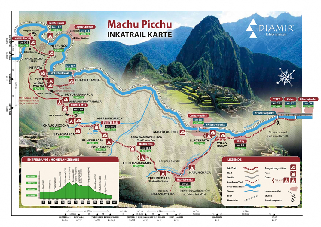
Foi em 1980, quando começamos em Cusco, carregávamos pequenas tendas, sacos de dormir, roupas quentes, bons sapatos e, claro, comida para todo o passeio. Senti-me em forma, mas teria que ser forte bastante para subir três montanhas, que deveriam ser trilhadas, cada uma com altura de 4.200 m, 4.000 m, 3.700 m, totalizando 44 km de percurso acidentado, intercalando entre subidas, descidas e caminhadas.
No km 88 desembarcamos do trem e atravessamos o rio Urubamba em uma cesta, um pouco deteriorada puxada por cordas. Depois de caminharmos algumas horas, passamos pela última aldeia e vimos as últimas pessoas que veríamos antes de chegar a Machu Picchu.
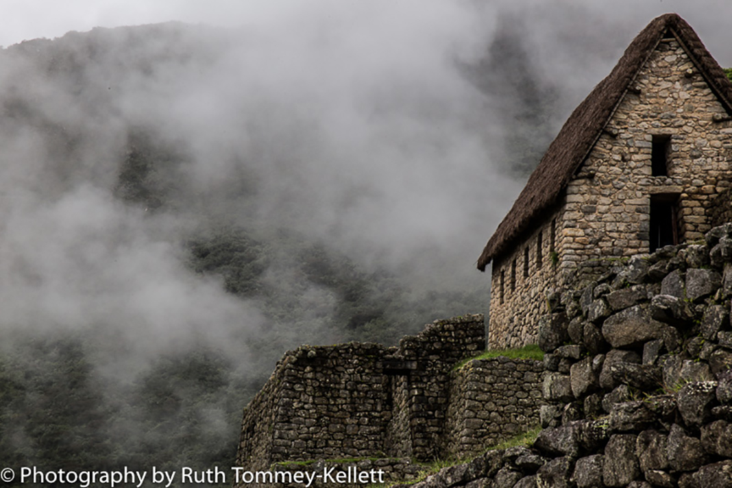
Caminhamos através de cânions com vegetação tropical, avistamos montanhas cobertas de neve e passamos por mais ruínas incas que estão localizadas nessa trilha original inca.
Lembro-me que dormimos uma noite em uma caverna, em outras nas nossas pequenas tendas. Uma manhã, quando acordamos, havia nevado. As noites eram congelantes, mas o cansaço e a fadiga das subidas extenuantes naquela altitude nos faziam adormecer com facilidade e dormir profundamente.
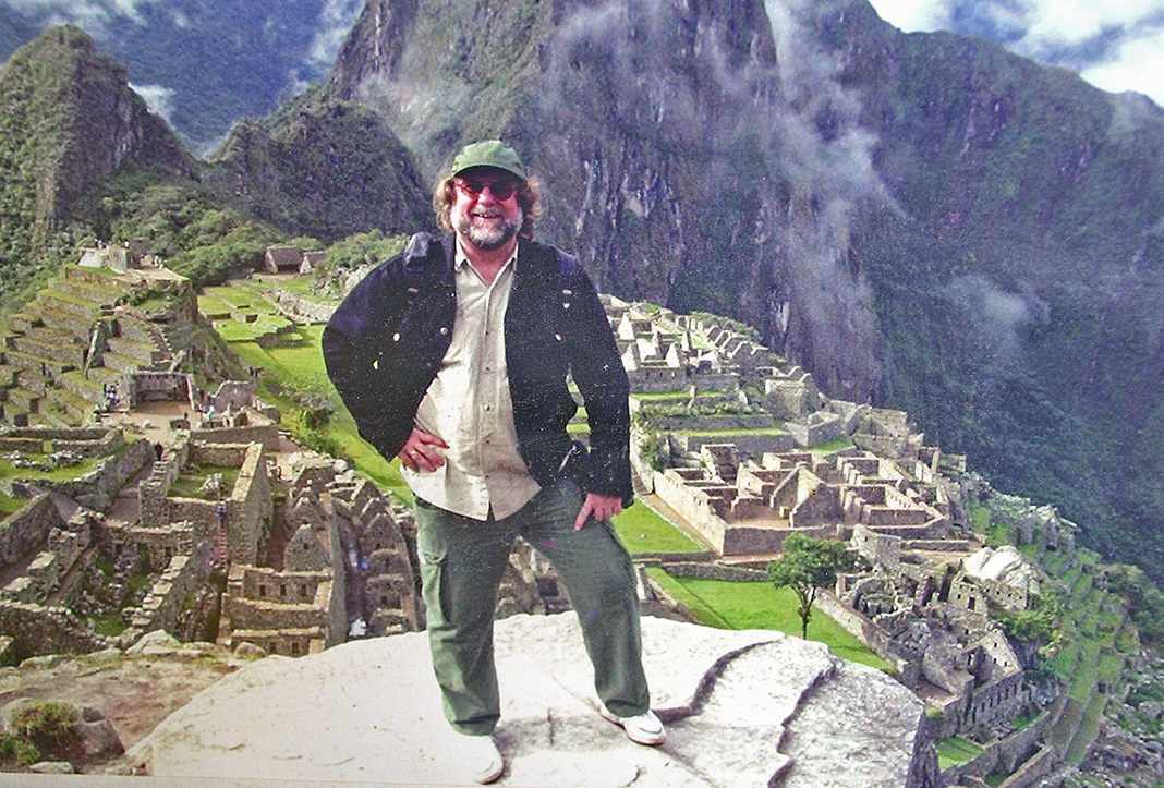
Estive em Cusco pela segunda vez em 2004 e também em Machu Picchu, mas, dessa vez, minha chegada foi em um trem turístico, muito confortável, rápido, tudo muito diferente daquela vez em 1980.
Atualmente (desde 2001), a Trilha Inca é percorrida apenas através de um passeio guiado e as reservas para esse tour se esgotam rapidamente. Tudo é organizado, existem áreas de camping, até mesmo com chuveiros, banheiros, camas e alimentação também é fornecida. Uma limitação de 500 pessoas por dia ajuda a manutenção da Trilha Inca para evitar o desgaste e, assim, proteger a natureza. Reserva antecipada é altamente recomendável. Mas ainda é absolutamente fascinante, este lugar místico para visitar e entrar nessa aura mágica e histórica e imaginar o mundo dos Incas. Antes e agora.
Nota: Infelizmente, eu encontrei apenas uma de minhas fotos de Machu Picchu, mas por sorte, amigos da Inglaterra me ajudaram, muito obrigado por isso…!!!


DAMALS und HEUTE – der Inka-Pfad in Peru
Es war immer mein Traum, den Inka-Pfad zu bewältigen, in den Anden Perus zu wandern und nach 4 Tagen als Belohnung überhalb von Machu Picchu anzukommen und diese traumhafte Ansicht auf diese Inka-Anlage geniessen zu können noch vor der Ankunft des Zuges aus Cusco, der dann Hunderte von Touristen ausspucken sollte.
Es war im Jahre 1980 als wir in Cusco aufbrachen, wir hatten kleine Zelte mit uns, Schlafsäcke, warme Bekleidung, gute Schuhe und natürlich Verpflegung für die gesamte Tour. Ich fühlte mich fit, aber würde das wirklich reichen für die 3 Gebirgspässe, die es zu überwinden galt (4.200 m, 4.000 m, 3.700 m) und die insgesamt 44 km lange sehr abwechslungsreiche aber auch harte zu absolvierende Wanderstrecke.
Bei KM 88 verliessen wir den Zug, in einem von Seilen gezogenen eher baufälligen Transportkorb überquerten wir den Urubamba Fluss, nach ein paar Stunden dann das letzte Dorf und die letzten Menschen, die wir zu Gesicht bekamen für die nächsten Tage.
Wir marschierten durch Schluchten mit tropischer Vegetation, wir sahen in der Ferne schneebedeckte Berge und passierten weitere Inka-Ruinen, die an diesem originären Inka-Pfad gelegen sind.
Ich erinnere mich, dass wir eine Nacht in einer Höhle schliefen, die weiteren in unseren kleinen Zelten, wobei wir eines morgens aufwachten und es sogar geschneit hatte, die Nächte waren eiskalt aber die Müdigkeit und Erschöpfung von den kräftezehrenden Anstiegen v.a. in diesen Höhen ließen uns problemlos und tief schliefen.
Ich war dann im Jahre 2004 ein weiteres Mal in Cusco und auch in Machu Picchu, dieses Mal erfolgte jedoch meine Anreise nur per Touristenzug, sehr angenehm, schnell und alles war total anders als damals.
HEUTE (seit 2001) kann der Inka-Pfad nur noch im Zuge einer geführten Wanderung begangen werden und er ist sehr oft ausgebucht. Alles ist organisiert, es gibt Campingbereiche, ja sogar Duschen, Toiletten, Betten und auch für Verpflegung ist gesorgt. Eine Limitierung der Personen auf 500 per Tag, die zum Inka-Pfad aufbrechen wollen, hilft den Wanderweg zu erhalten, Müll zu vermeiden und somit die Natur zu schützen. Eine frühzeitige Buchung ist sehr ratsam.
Aber nach wie vor ist es absolut faszinierend, diesen mystischen Ort zu besuchen und sich seiner magischen Anziehungskraft und Geschichte hinzugeben und in diese Welt der Inkas einzutauchen. Damals und Heute.
Anmerkung: Leider fand ich nur noch eines meiner Fotos von Machu Picchu, glüclicherweise konnten jedoch Freunde aus England mit Fotos aushelfen, Danke hierfür…!!!

THEN and NOW – the Inca Trail in Peru
It was always my dream to cope with the Inca Trail, to hike in the Andes of Peru and to arrive after 4 days as a reward above Machu Picchu and to be able to enjoy this wonderful view onto this Inca plant even before the arrival of the train from Cusco which should then discharge hundreds of tourists.
It was in 1980 when we started in Cusco, we had small tents with us, sleeping bags, warm clothes, good shoes and, of course, food for the whole tour. I felt fit, but would that really be enough for the 3 mountain passes, which had to be overcome (4,200 m, 4,000 m, 3,700 m) and the total of 44 km long very varied but also hard to be completed walking route.
At KM 88 we left the train, in a chariot drawn by ropes rather dilapidated transport basket we crossed the Urubamba River, after a few hours then the last village and the last people we got to see for the next few days.
We marched through canyons with tropical vegetation, we saw in the distance snow-capped mountains and passed more Inca ruins which are located at this original Inca Trail.
I remember that we slept one night in a cave, the others in our small tents, where we woke up one morning on a mountain pass and it had even snowed, the nights were freezing but the tiredness and fatigue from the grueling climbs at this altitude let us easily and deeply sleep.
I was then in 2004 one more time in Cusco and also in Machu Picchu, this time my arrival done only by tourist train, very comfortable, fast and everything was totally different then.
TODAY (since 2001), the Inca Trail is committed only during a guided walk and it is very often booked out. Everything is organized, there are camping areas, and even showers, toilets, beds and also catering is provided. A limitation of persons to 500 per day making the Inca Trail help to maintain the trail to avoid waste and thus to protect nature. Early booking is highly recommended.
But still it is absolutely fascinating, this mystical place to visit and indulge this magical aura and history and to imagine the world of the Incas. Then and Now.
Note: Unfortunately, I found only one of my photos of Machu Picchu, but by luck friends from England could help out with photos, thank you very much for this…!!!