A primeira vez que ouvi falar sobre Ushuaia foi quando Erich me disse que gostaria de conhecer o “fim do mundo”. Sim, a cidade é conhecida como o “fim do mundo” e quase tudo lá está relacionado com essa expressão: “trem do fim do mundo”, “correio do fim do mundo”, dentre outros exemplos que o visitante vai vendo quando visita a cidade.
Ushuaia é a capital da província da Terra do Fogo e integra a Patagônia Argentina.
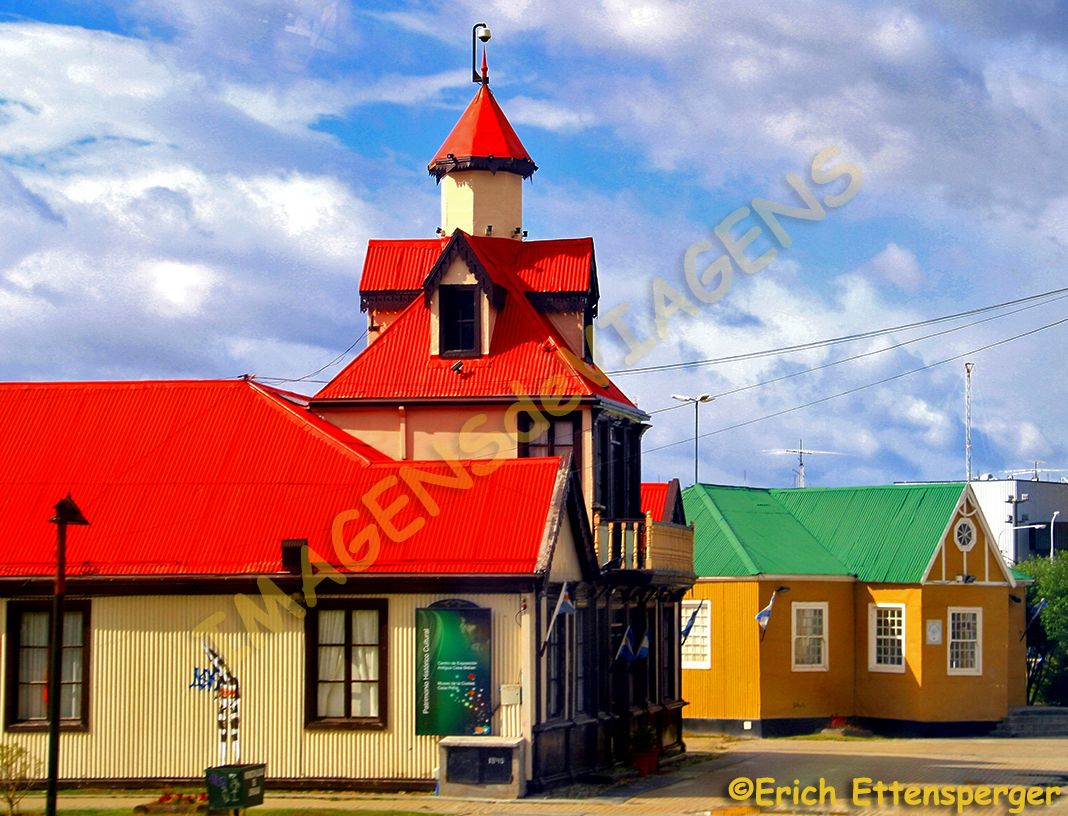
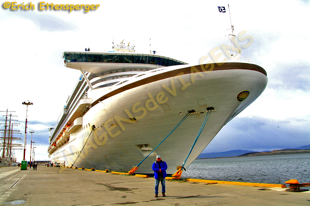
Chegamos a Ushuaia em um grande navio, cuja uma das paradas era no porto de Ushuaia. Era uma manhã ensolarada e ficamos impressionados com a beleza do lugar. A cidade é emoldurada pelas montanhas Martial e pela Baía de Ushuaia, o que lhe confere uma beleza especial.
Ushuaia foi criada a partir de um posto da polícia marítima em 1884 e abrigou uma prisão até 1947. Hoje em dia é uma cidade turística com aproximadamente 75.000 habitantes e faz parte da rota de muitos cruzeiros. É ponto de partida de muitos barcos que visitam a Antártica.
Os principais pontos de interesse de Ushuaia são: Canal de Beagle, Parque Nacional da Terra do Fogo, Vale da Terra Maior, o passeio no Trem do Fim do Mundo, o Museu Marítimo, os lagos Escondido e Fagnano, Trilha de Lumberjack, dentre outros. São muitas as atrações, sendo que as naturais encantam pela beleza estonteante. O passeio de barco pelo famoso Canal de Beagle é espetacular!
Ushuaia é um destino turístico que pode ser visitado tanto no inverno quanto no verão. Se você for na época mais fria, será possível esquiar, curtir a neve. Se preferir o verão, você poderá fazer belas caminhadas, visitar lagos, apreciar a flora e a fauna, não falta o que fazer, depende do que você gosta de fazer. No nosso caso, quisemos ver belas paisagens sem sentir tanto frio e vento forte, por isso fomos no mês de fevereiro, considerado a época de verão por lá.
Se você é amante da natureza, recomendo que planeje uma viagem para o “Fim do Mundo”, a cidade mais austral do mundo.
Vista geral da cidade a partir do porto / Ansicht auf die Stadt vom Hafen aus / General view of the city from the portAs montanhas, a neve e o navio / Die Berge, Schnee und das Schiff / The mountains, snow and the shipÔnibus de turismo / Tour-Bus / Tourism busTelhados coloridos / farbige Dächer / colored roofsCentro da cidade / Zentrum der Stadt / downtownA nossa casa em Ushuaia / unsere Unterkunft in Ushuaia /our home in UshuaiaPaisagem fascinante / faszinierende Landschaft / fascinating landscape
Ushuaia – das Tor zur Antarktis
Das erste Mal hörte ich von Ushuaia, als Erich mir sagte, daß er gerne das “Ende der Welt” besuchen möchte. Ja, die Stadt ist als das “Ende der Welt” bekannt und fast alles bezieht sich darauf wie z.B. der “Zug zum Ende der Welt” oder “die Post am Ende der Welt”.
Ushuaia ist die Hauptstadt der Provinz Feuerland (Tierra del Fuego) und Bestandteil Patagoniens in Argentinien.
Wir erreichten Ushuaia auf einem großen Kreuzfahrtschiff an einem sonnigen Morgen und wir waren von der Schönheit des Ortes beeindruckt. Die Stadt ist von Bergen umgeben und die Martial Ushuaia Bucht verleiht ihr eine ganz besondere Schönheit.
Ushuaia wurde 1884 als maritimer Polizeiposten geschaffen und beherbergte bis 1947 ein Gefängnis. Heute ist es eine touristische Stadt mit etwa 75.000 Einwohnern und Programmpunkt auf der Route vieler Kreuzfahrten. Es ist auch der Ausgangspunkt für viele Schiffe auf dem Weg zur Antarktis.
Die wichtigsten Sehenswürdigkeiten in Ushuaia sind: der Beagle-Kanal, der Feuerland Nationalpark, das Tal „Vale da Terra Maior“, eine Zugfahrt zum Ende der Welt, das Maritime Museum, die Seen Escondido und Fagnano und der „Lumberjack Trail“. Es gibt viele Sehenswürdigkeiten mit dem natürlichen Charme von atemberaubenden Schönheit. Eine Bootsfahrt entlang dem berühmten Beagle-Kanal ist schlichtweg spektakulär!
Ushuaia ist ein Reiseziel, das sowohl im Winter als auch im Sommer besucht werden kann. In der kalten Jahreszeit können Sie Ski fahren und den Schnee genießen. Im Sommer dagegen können Sie schöne Ausflugstouren machen, Seen besuchen, die Flora und Fauna genießen, es hängt alles davon ab, was Sie gerne tun wollen. In unserem Fall wollten wir ohne große Kälte und Wind einfach schöne Landschaftsszenarien erleben, also machten wir unsere Reise im Februar, in der Sommersaison.
Falls Sie Naturliebhaber sind, dann empfehle ich Ihnen, eine Reise an das “Ende der Welt” zu planen, nach Ushuaia, der südlichsten Stadt der Welt.
Vista geral da cidade a partir do porto / Ansicht auf die Stadt vom Hafen aus / General view of the city from the portAs montanhas, a neve e o navio / Die Berge, Schnee und das Schiff / The mountains, snow and the shipÔnibus de turismo / Tour-Bus / Tourism busTelhados coloridos / farbige Dächer / colored roofsCentro da cidade / Zentrum der Stadt / downtownA nossa casa em Ushuaia / unsere Unterkunft in Ushuaia /our home in UshuaiaPaisagem fascinante / faszinierende Landschaft / fascinating landscape
Ushuaia – the gateway to Antarctica
The first time I heard of Ushuaia was when Erich told me that he would like to visit the “end of the world”. Yes, the city is known as the “end of the world” and almost everything refers to such as the “train to the end of the world” or “the post-office at the end of the world“.
Ushuaia is the capital of the province of Tierra del Fuego (fire land) and part of Patagonia in Argentina.
We reached Ushuaia on a large cruise ship on a sunny morning and we were impressed by the beauty of the place. The city is surrounded by mountains and the Martial Ushuaia Bay gives it a very special beauty.
Ushuaia was created in 1884 as the maritime police station and housed until 1947 a prison. Today it is a tourist town with about 75,000 inhabitants and program point on the route of many cruises. It is also the starting point for many ships on the way to Antarctica.
The main attractions in Ushuaia include the Beagle Channel, the Tierra del Fuego National Park, the valley “Vale da Terra Maior”, a train ride to the end of the world, the Maritime Museum, the Escondido and Fagnano Lakes and the “Lumberjack Trail”. There are many attractions offfering the natural charm of breathtaking beauty. A boat trip along the famous Beagle Channel is simply said spectacular!
Ushuaia is a destination that can be visited both in winter and in summer. In the cold season you can ski and enjoy the snow. In summer, you can make beautiful excursion tours, visit lakes, enjoy the flora and fauna, it all depends on what you want like to do. In our case we just wanted to experience beautiful landscape scenarios without much wind and cold, so we did our trip in February, during the summer season.
If you love nature then I recommend you to plan a trip to the “end of the world”, to Ushuaia, the southernmost city in the world.
Vista geral da cidade a partir do porto / Ansicht auf die Stadt vom Hafen aus / General view of the city from the portAs montanhas, a neve e o navio / Die Berge, Schnee und das Schiff / The mountains, snow and the shipÔnibus de turismo / Tour-Bus / Tourism busTelhados coloridos / farbige Dächer / colored roofsCentro da cidade / Zentrum der Stadt / downtownA nossa casa em Ushuaia / unsere Unterkunft in Ushuaia /our home in UshuaiaPaisagem fascinante / faszinierende Landschaft / fascinating landscape
Quando você estiver lendo este post, estará completando um ano que visitei Berlim pela terceira vez. Vou e volto e minha atração e interesse pela cidade continuam o mesmo. Cada vez descubro uma área diferente para conhecer ou quero rever alguma coisa.
Fiquei hospedada em um hotel localizado na área denominada “Mitte”, próximo a uma estação do metrô chamada “Gleisdreieck”, porém parecia que eu estava em um bairro afastado do centro, tudo silencioso, poucos automóveis.
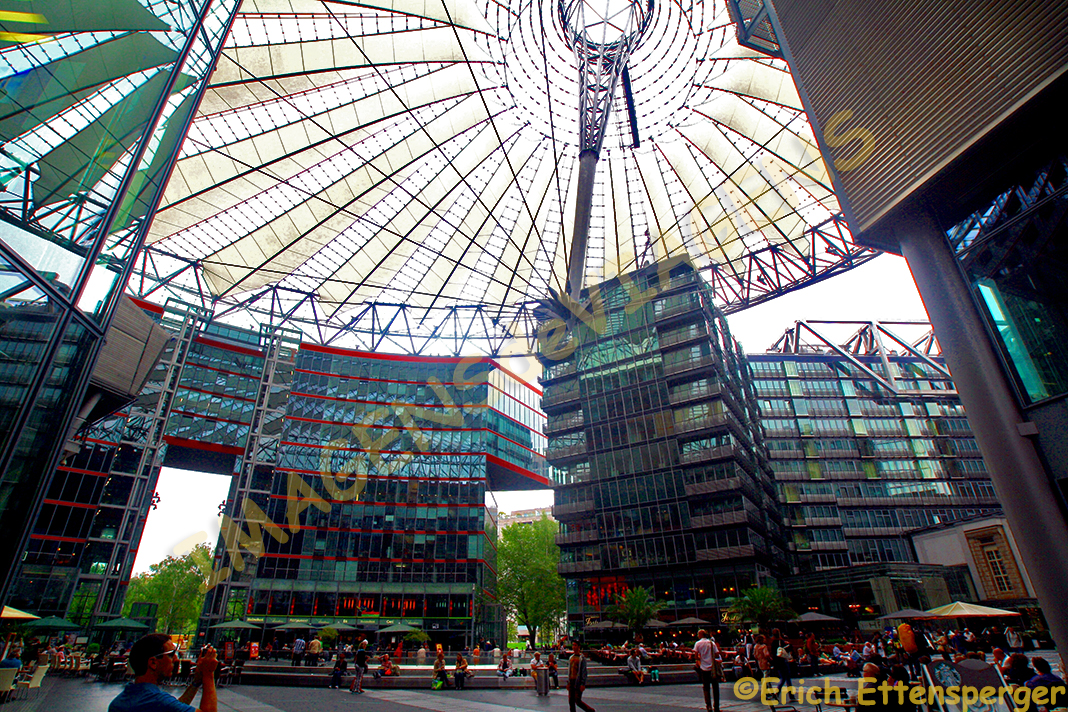
Para imergir na cidade, fui direto tomar café da manhã na Postdamer Platz, com o shopping “Arcaden”, a “Weinhaus Huth” e próximo ao Sony Center, nas proximidades do Museu do Cinema. Ah, Berlim, como a diversidade de seus habitantes me impressiona. Quando estou caminhando nas ruas escuto vários idiomas, vejo pessoas com roupas e adereços estranhos, chega a ser divertido e interessante.
Berlim é um paraíso para arquitetos porque implantou projetos urbanísticos arrojados (caso da Postdamer Platz, por exemplo), porque tem edifícios com concepções arquitetônicas criativas e alguns, bem futuristas, e porque sempre tem alguma novidade espetacular em diferentes áreas. Berlim tem muitas e interessantes atrações para todos os gostos. As ruas de Berlim são sempre surpreendentes. Dessa vez, vi um casal de recém casados (felizes e confiantes no futuro), duas limusines, uma rosa e uma preta, estacionadas em frente ao Portão de Bradenburgo, sendo fotografados. Para completar esse cenário de cinema, um velho músico tocava uma melodia que lembrava os tempos que antecederam a Segunda Guerra. Se você gosta de lojas de qualidade, a rua Kurfürstendamm vai lhe encantar com suas lojas de grife e com transeuntes elegantes.
Berlim é moderna e fascinante, mas ao mesmo tempo pode ser o lar daqueles que não tem casa, que se postam em frente à estação de trem ou circulam pelas estações de metrô pedindo dinheiro aos que transitam nessas áreas. Berlim também é uma cidade que atrai ricos empresários que chegam para investir em novidades surpreendentes.
São muitos os turistas que visitam essa senhora de idade. Os jovens chegam em busca das baladas que começam depois da meia noite e os mais velhos a visitam para assistir um concerto da Filarmônica de Berlim, um musical ou um outro show que esteja acontecendo em seus vários teatros. Muitos turistas são atraídos pela Ilha dos Museus recheada de preciosidades, como o famoso busto de Nefertiti. Cada um tem seu motivo para visitar Berlim, eu vou voltar sempre simplesmente para estar lá e aproveitar de tudo um pouco dessa cidade incrível que me fascina de forma especial. Eu sempre digo aos meus amigos que são duas as cidades que sempre vou voltar: Berlim e Cingapura.
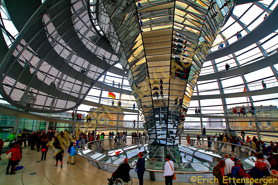
Muro de Berlim/Berliner Mauer/ Berlin WallCentro da Sony/Sony CenterPonte de Oberbaum/Oberbaumbrücke/Oberbaum BridgeParlamento Alemão/ Parlament-Reichstag/German Parliament
Distrito governamental/Im Regierungsviertel/In the government district
Berlin, ich werde immer zurückkommen
Wenn Sie diesen Beitrag lesen, wird es ein Jahr her sein, seit ich Berlin zum dritten Mal besucht habe. Ich komme und gehe und die Anziehungskraft und mein Interesse an der Stadt sind immer noch gleichermaßen stark. Jedes Mal entdecke ich neue Bereiche.
Ich war in einem Hotel im Viertel namens “Berlin Mitte”untergebracht, direkt neben einer U-Bahn-Station “Gleisdreieck” genannt, aber es fühlte sich nicht an wie im Zentrum, alles war ruhig, nur wenige Autos.
Um in die Stadt einzutauchen, ging ich zum Frühstücken direkt an den Potsdamer Platz mit dem Einkaufszentrum “Arkaden”, dem “Weinhaus Huth” und daneben dem Sony Center, in der Nähe dann das „Kinomuseum“.
Oh, Berlin, die Vielfalt seiner Bewohner beeindruckt mich. Beim Spazieren in den Straßen höre ich viele Sprachen, sehe ich Menschen mit seltsamer Kleidung und seltsamen Requisiten, alles ist hochinteressant.
Berlin ist ein Paradies für Architekten, weil es implantiert imposante städtische Projekte wie z.B. der Potsdamer Platz, es präsentiert Gebäude mit sehr kreativen architektonischen Entwürfen, teilweise auch sehr futuristisch, und immer bietet es einige spektakuläre Neuheiten in verschiedensten Bereichen.
Berlin offeriert viele interessante Attraktionen für jeden Geschmack. Berliner Straßen zeigen immer wieder Erstaunliches. Dieses Mal sah ich zwei Limousinen, eine rosefarbene und eine schwarze, vor dem Brandenburger Tor geparkt, mit Jungvermählten, die sich dort, glücklich und zuversichtlich in die Zukunft blickend, fotografieren ließen. Um dieses Szenario wie im Kino zu vervollständigen, war ein alter Musiker zugegen, eine Melodie spielend, die an die Epoche vor dem Zweiten Weltkrieg erinnerte.
Falls Sie Geschäfte mit hoher Qualität mögen, der Kurfürstendamm mit seinen Designerläden und eleganten Passanten wird Sie verzaubern.
Berlin ist modern und faszinierend, aber zugleich auch die Heimat von denen, die kein Zuhause haben, die vor den Bahnhöfen stehen oder den U-Bahn-Stationen, den Bereichen mit hohem Passagieraufkommen, und um Geld bitten.
Berlin ist auch eine Stadt, in die betuchte Geschäftsleute kommen, um in neue innovative Geschäftsideen zu investieren.
Viele Touristen kommen, um „diese alte Dame“ zu besuchen. Junge Leute kommen auf der Suche nach „Events“, die nach Mitternacht beginnen, ältere Touristen besuchen ein Konzert der Berliner Philharmoniker, ein Musical (wie wir „Hinterm Horizont“ – Udo Lindenberg) oder eine der vielen anderen Shows im Angebot dieser City.
Viele Touristen werden auch von der Museums-Insel angezogen mit von Schätzen gefüllten Museen wie z.B. der Büste der Nofretete.
Jeder hat seine Gründe, um Berlin zu besuchen, ich selbst werde immer wieder dort sein wollen und ein bisschen von allem dieser erstaunlichen Stadt zu genießen, die mich in besonderer Weise fasziniert.
Ich sage immer zu meinen Freunden, die beiden Städte, in die ich immer wieder zurückkehren möchte, sind: Berlin und Singapur
Muro de Berlim/Berliner Mauer/ Berlin WallCentro da Sony/Sony CenterPonte de Oberbaum/Oberbaumbrücke/Oberbaum BridgeParlamento Alemão Parlament-Reichstag/German ParliamentDistrito governamental/Im Regierungsviertel/In the government district
Berlin, I will always come back
If you read this post, it will be a year since I visited Berlin for the third time. I come and go and the attraction and my interest in the city are still equally strong. Every time I discover new areas.
I was accomodated in a hotel in the neighborhood called “Berlin Mitte”, right next to a subway station called “Gleisdreieck”, but it did not feel like in the center, everything was quiet, few cars only.
To get to know the city I went to have breakfast directly at the Potsdamer Platz with the mall “arcades”, the “Weinhaus Huth” next to the Sony Center, near the “Cinema Museum”.
Oh, Berlin, the diversity of its people impressed me. Whilst walking in the streets I hear many languages, I see people with strange clothes and strange props, everything is highly interesting.
Berlin is a paradise for architects because it implants imposing urban projects such as the „Potsdamer Platz“, it presents buildings with very creative architectural designs, sometimes very futuristic, and always it offers some spectacular innovations in diverse areas.
Berlin offers many interesting attractions for every taste. Berlin streets repeatedly show amazing things. This time I saw e.g. two big limousines, a rose-colored one and one black, parked in front of the „Brandenburger Tor“, with newlyweds there were happy and confident looking into their future, photographing themselves. This scenario as to complete in a cinema, an old musician was playing a melody reminiscent of the period before the Second World War.
If you like shops with high quality, the Kurfürstendamm with its designer shops and elegant passers will enchant you.
Berlin is modern and fascinating, but at the same time also the home of those who have no home, standing in front of the train stations or the metro stations, these areas with high passenger volumes, and asking for money.
Berlin is also a city to come to the well-heeled businessmen to invest in new innovative business ideas.
Many tourists come to visit “this old Lady”. Young people come in search of “events” that begin after midnight, elderly tourists visit a concert of the Berlin Philharmonic, a Musical (as us “Beyond the Horizon” – Udo Lindenberg) or one of many other shows on offer in this City.
Many tourists are also attracted by the „Museum-Island“ with museums filled of treasures such as the bust of Nefertiti.
Everybody has his/hers reasons to visit Berlin, I myself will always want to be there and a bit to enjoy all of this amazing city that fascinates me in a very special way.
I always tell my friends, the two cities I want to return always again and again are: Berlin and Singapore
Muro de Berlim/Berliner Mauer/ Berlin WallCentro da Sony/Sony CenterPonte de Oberbaum/Oberbaumbrücke/Oberbaum BridgeParlamento Alemão/Parlament-Reichstag/German Parliament
Distrito governamental/Im Regierungsviertel/In the government district
Há muito tempo atrás e nos dias atuais – a Trilha Inca no Peru
Um sonho tornado realidade/Ein Traum wird wahr /A dream becomes true
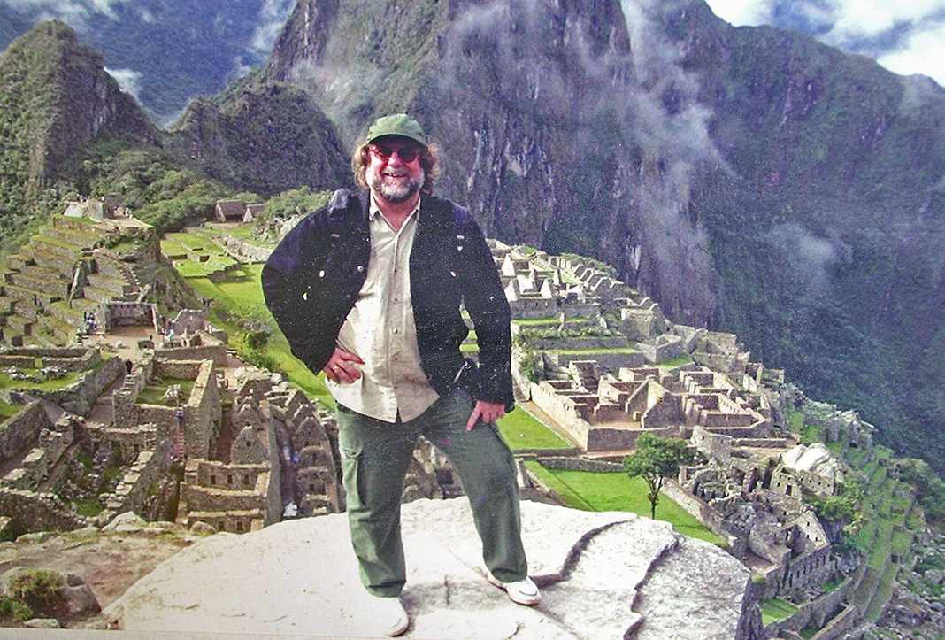
Sempre foi meu sonho percorrer a Trilha Inca, caminhar nos Andes do Peru e chegar após 4 dias, como uma recompensa, acima de Machu Picchu e desfrutar da vista maravilhosa sobre a cidade Inca, antes mesmo da chegada do trem que vem de Cusco, com centenas de turistas.
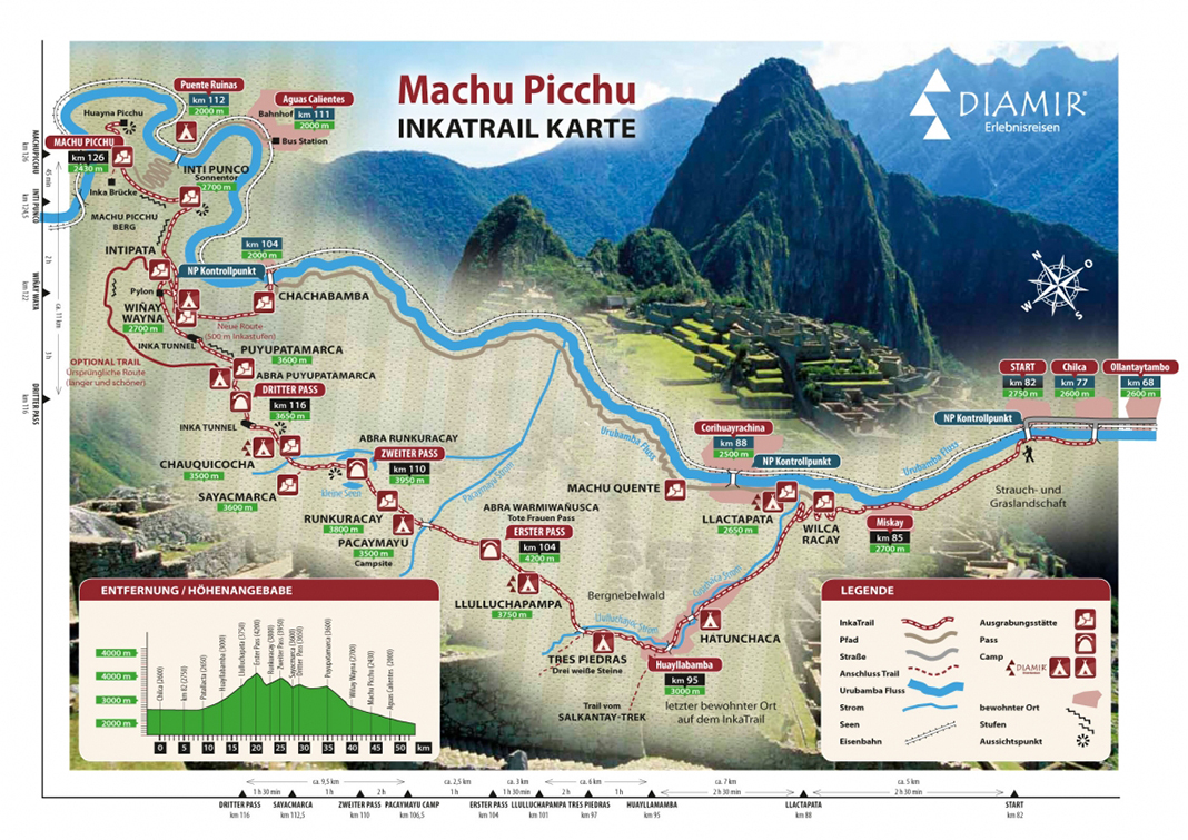
Foi em 1980, quando começamos em Cusco, carregávamos pequenas tendas, sacos de dormir, roupas quentes, bons sapatos e, claro, comida para todo o passeio. Senti-me em forma, mas teria que ser forte bastante para subir três montanhas, que deveriam ser trilhadas, cada uma com altura de 4.200 m, 4.000 m, 3.700 m, totalizando 44 km de percurso acidentado, intercalando entre subidas, descidas e caminhadas.
No km 88 desembarcamos do trem e atravessamos o rio Urubamba em uma cesta, um pouco deteriorada puxada por cordas. Depois de caminharmos algumas horas, passamos pela última aldeia e vimos as últimas pessoas que veríamos antes de chegar a Machu Picchu.
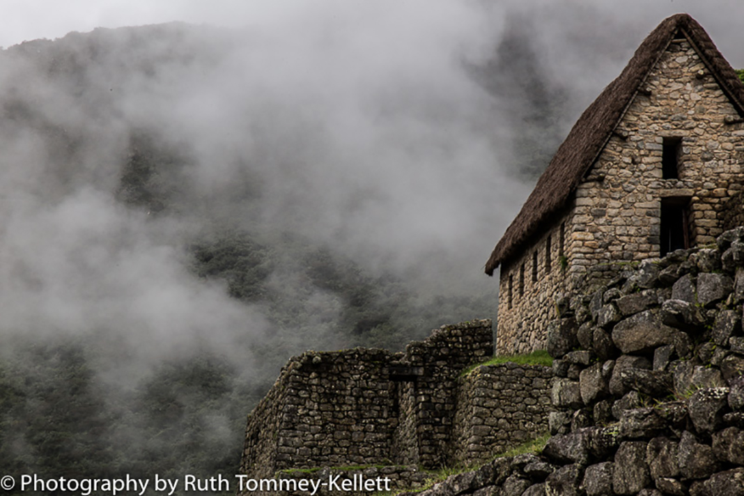
Caminhamos através de cânions com vegetação tropical, avistamos montanhas cobertas de neve e passamos por mais ruínas incas que estão localizadas nessa trilha original inca.
Lembro-me que dormimos uma noite em uma caverna, em outras nas nossas pequenas tendas. Uma manhã, quando acordamos, havia nevado. As noites eram congelantes, mas o cansaço e a fadiga das subidas extenuantes naquela altitude nos faziam adormecer com facilidade e dormir profundamente.
Estive em Cusco pela segunda vez em 2004 e também em Machu Picchu, mas, dessa vez, minha chegada foi em um trem turístico, muito confortável, rápido, tudo muito diferente daquela vez em 1980.
Atualmente (desde 2001), a Trilha Inca é percorrida apenas através de um passeio guiado e as reservas para esse tour se esgotam rapidamente. Tudo é organizado, existem áreas de camping, até mesmo com chuveiros, banheiros, camas e alimentação também é fornecida. Uma limitação de 500 pessoas por dia ajuda a manutenção da Trilha Inca para evitar o desgaste e, assim, proteger a natureza. Reserva antecipada é altamente recomendável. Mas ainda é absolutamente fascinante, este lugar místico para visitar e entrar nessa aura mágica e histórica e imaginar o mundo dos Incas. Antes e agora.
Nota: Infelizmente, eu encontrei apenas uma de minhas fotos de Machu Picchu, mas por sorte, amigos da Inglaterra me ajudaram, muito obrigado por isso…!!!
Casas, artisticamente construídos sem argamassa, altas acima do vale /Häuser, kunstvoll ohne Mörtel gebaut, hoch über dem Tal/Houses, artfully constructed without any mortar, high above the valleyCada pedra tem que ser correta positionada /Jeder Stein muß genau sitzen /Each stone has to be correctly positionedMuitos terraços e muitos turistas/Viele Terrassen und viele Touristen/Many terraces and many touristsTerraços íngremes/Steile Terrassen/Steep terracesOlhe bem para o rio Urubamba / Blick tief hinunter auf den Fluß Urubamba / Look deep down at the river UrubambaCasa e nuvens nas encostas das montanhas / Haus und Wolken an den Berghängen / House and clouds on the mountain slopesMachu PicchuMachu Picchu
DAMALS und HEUTE – der Inka-Pfad in Peru
Um sonho tornado realidade/Ein Traum wird wahr /A dream becomes true
Es war immer mein Traum, den Inka-Pfad zu bewältigen, in den Anden Perus zu wandern und nach 4 Tagen als Belohnung überhalb von Machu Picchu anzukommen und diese traumhafte Ansicht auf diese Inka-Anlage geniessen zu können noch vor der Ankunft des Zuges aus Cusco, der dann Hunderte von Touristen ausspucken sollte.
Es war im Jahre 1980 als wir in Cusco aufbrachen, wir hatten kleine Zelte mit uns, Schlafsäcke, warme Bekleidung, gute Schuhe und natürlich Verpflegung für die gesamte Tour. Ich fühlte mich fit, aber würde das wirklich reichen für die 3 Gebirgspässe, die es zu überwinden galt (4.200 m, 4.000 m, 3.700 m) und die insgesamt 44 km lange sehr abwechslungsreiche aber auch harte zu absolvierende Wanderstrecke.
Bei KM 88 verliessen wir den Zug, in einem von Seilen gezogenen eher baufälligen Transportkorb überquerten wir den Urubamba Fluss, nach ein paar Stunden dann das letzte Dorf und die letzten Menschen, die wir zu Gesicht bekamen für die nächsten Tage.
Wir marschierten durch Schluchten mit tropischer Vegetation, wir sahen in der Ferne schneebedeckte Berge und passierten weitere Inka-Ruinen, die an diesem originären Inka-Pfad gelegen sind.
Ich erinnere mich, dass wir eine Nacht in einer Höhle schliefen, die weiteren in unseren kleinen Zelten, wobei wir eines morgens aufwachten und es sogar geschneit hatte, die Nächte waren eiskalt aber die Müdigkeit und Erschöpfung von den kräftezehrenden Anstiegen v.a. in diesen Höhen ließen uns problemlos und tief schliefen.
Ich war dann im Jahre 2004 ein weiteres Mal in Cusco und auch in Machu Picchu, dieses Mal erfolgte jedoch meine Anreise nur per Touristenzug, sehr angenehm, schnell und alles war total anders als damals.
HEUTE (seit 2001) kann der Inka-Pfad nur noch im Zuge einer geführten Wanderung begangen werden und er ist sehr oft ausgebucht. Alles ist organisiert, es gibt Campingbereiche, ja sogar Duschen, Toiletten, Betten und auch für Verpflegung ist gesorgt. Eine Limitierung der Personen auf 500 per Tag, die zum Inka-Pfad aufbrechen wollen, hilft den Wanderweg zu erhalten, Müll zu vermeiden und somit die Natur zu schützen. Eine frühzeitige Buchung ist sehr ratsam.
Aber nach wie vor ist es absolut faszinierend, diesen mystischen Ort zu besuchen und sich seiner magischen Anziehungskraft und Geschichte hinzugeben und in diese Welt der Inkas einzutauchen. Damals und Heute.
Anmerkung: Leider fand ich nur noch eines meiner Fotos von Machu Picchu, glüclicherweise konnten jedoch Freunde aus England mit Fotos aushelfen, Danke hierfür…!!!
Casas, artisticamente construídos sem argamassa, altas acima do vale /Häuser, kunstvoll ohne Mörtel gebaut, hoch über dem Tal/Houses, artfully constructed without any mortar, high above the valleyCada pedra tem que ser correta positionada /Jeder Stein muß genau sitzen /Each stone has to be correctly positionedMuitos terraços e muitos turistas/Viele Terrassen und viele Touristen/Many terraces and many touristsTerraços íngremes/Steile Terrassen/Steep terracesOlhe bem para o rio Urubamba / Blick tief hinunter auf den Fluß Urubamba / Look deep down at the river UrubambaCasa e nuvens nas encostas das montanhas / Haus und Wolken an den Berghängen / House and clouds on the mountain slopesMachu PicchuMachu Picchu
THEN and NOW – the Inca Trail in Peru
Um sonho tornado realidade/Ein Traum wird wahr /A dream becomes true
It was always my dream to cope with the Inca Trail, to hike in the Andes of Peru and to arrive after 4 days as a reward above Machu Picchu and to be able to enjoy this wonderful view onto this Inca plant even before the arrival of the train from Cusco which should then discharge hundreds of tourists.
It was in 1980 when we started in Cusco, we had small tents with us, sleeping bags, warm clothes, good shoes and, of course, food for the whole tour. I felt fit, but would that really be enough for the 3 mountain passes, which had to be overcome (4,200 m, 4,000 m, 3,700 m) and the total of 44 km long very varied but also hard to be completed walking route.
At KM 88 we left the train, in a chariot drawn by ropes rather dilapidated transport basket we crossed the Urubamba River, after a few hours then the last village and the last people we got to see for the next few days.
We marched through canyons with tropical vegetation, we saw in the distance snow-capped mountains and passed more Inca ruins which are located at this original Inca Trail.
I remember that we slept one night in a cave, the others in our small tents, where we woke up one morning on a mountain pass and it had even snowed, the nights were freezing but the tiredness and fatigue from the grueling climbs at this altitude let us easily and deeply sleep.
I was then in 2004 one more time in Cusco and also in Machu Picchu, this time my arrival done only by tourist train, very comfortable, fast and everything was totally different then.
TODAY (since 2001), the Inca Trail is committed only during a guided walk and it is very often booked out. Everything is organized, there are camping areas, and even showers, toilets, beds and also catering is provided. A limitation of persons to 500 per day making the Inca Trail help to maintain the trail to avoid waste and thus to protect nature. Early booking is highly recommended.
But still it is absolutely fascinating, this mystical place to visit and indulge this magical aura and history and to imagine the world of the Incas. Then and Now.
Note: Unfortunately, I found only one of my photos of Machu Picchu, but by luck friends from England could help out with photos, thank you very much for this…!!!
Casas, artisticamente construídos sem argamassa, altas acima do vale /Häuser, kunstvoll ohne Mörtel gebaut, hoch über dem Tal/Houses, artfully constructed without any mortar, high above the valleyCada pedra tem que ser correta positionada /Jeder Stein muß genau sitzen /Each stone has to be correctly positionedMuitos terraços e muitos turistas/Viele Terrassen und viele Touristen/Many terraces and many touristsTerraços íngremes/Steile Terrassen/Steep terracesOlhe bem para o rio Urubamba / Blick tief hinunter auf den Fluß Urubamba / Look deep down at the river UrubambaCasa e nuvens nas encostas das montanhas / Haus und Wolken an den Berghängen / House and clouds on the mountain slopesMachu PicchuMachu Picchu
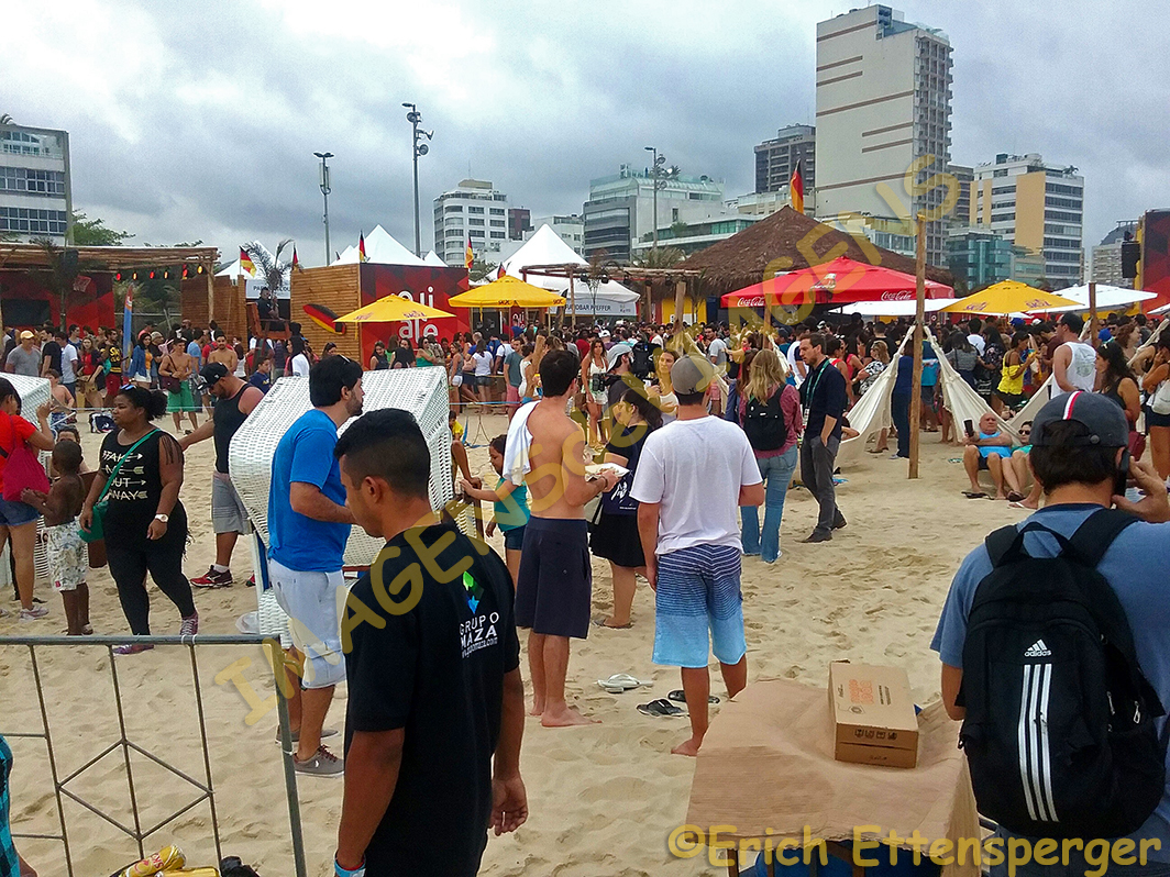
As Olimpíadas realizadas no Rio foram um sucesso e isso ninguém tem dúvida. Eu nunca havia participado de uma e pensava que o evento se limitava a realização das competições, que, claro, é a espinha dorsal do evento. Porém, alguns dos países que participam do evento aproveitam a oportunidade para promover o destino.
Durante a Rio 2016 foram instaladas “casas temáticas” distribuídas em diferentes bairros da cidade e com diferentes concepções. Os países que tiveram essas casas foram os seguintes: Colômbia, Austrália, Finlândia, Brasil, México, Portugal, Alemanha, Suíça, Japão, República Tcheca, Eslováquia, Casa África, Japão, Pyeongchang (Casa da Coréia do Sul), Holanda, Dinamarca, Suíça, Catar, Grã-Bretanha, Jamaica, Hungria.
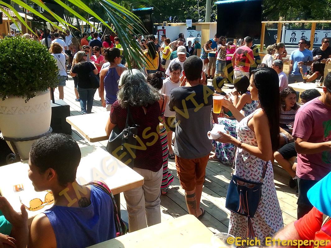
Tive a oportunidade de visitar duas dessas casas, a da Áustria e a da Alemanha. Gostei muito e acho que não foi somente eu que gostei, milhares de pessoas adoraram visitar esses locais, a prova disso se viu nas longas filas que se formaram nas entradas dessas casas. A minha primeira tentativa de visitar a Casa da Áustria falhou porque a fila era imensa, cheguei lá por volta das 17 horas e foi simplesmente impossível entrar. Consegui no dia seguinte porque fui cedo. Essa casa funcionava nos jardins do Clube Botafogo, tinha comida típica e bebidas. A Áustria trouxe músicos de alta qualidade para fazerem shows e isso se tornou a grande atração da casa. Tive a oportunidade de assistir um show de Maria Kofler, saxofonista, que encantou o público. Conversei um minuto com ela e a mesma me disse que todos os cds que tinha trazido para vender foram vendidos. A organização dessa casa não esperava um sucesso tão grande!
No mesmo dia, Erich e eu fomos visitar a Casa da Alemanha. Outra concepção: uma estrutura de madeira montada nas areias da Praia do Leblon. Tinha uma área para palestras, comida típica, um grande telão, jogos para crianças. As pessoas adoraram o local e a fila para entrar era imensa!!!
Passei em frente à casa da Dinamarca, também localizada na beira da praia do Leblon e também muito interessante. Soube que a Casa da França, o Club France, que funcionou na sede da Sociedade Hípica Brasileira no Rio atraiu um grande público!
Não tive tempo para visitar mais casas, mas achei o programa muito interessante. Os atletas e personalidades dos países costumavam visitar essas casas no final do dia. Havia outras casas que não estavam abertas ao público e que eram apenas para convidados, como a do Canadá, por exemplo.
Se você for assistir os jogos das próximas Olímpiadas a serem realizadas em Tóquio, em 2020, não deixe de incluir a visita a algumas das casas temáticas!
Mulher índia, vestida com trajes típicos em frente à Casa Brasil/ Eine Indio-Frau in traditioneller Kleidung vor dem Haus Brasilien/An indigenous woman in traditional clothing in front of the house BrazilCrianças de um projeto social tocando em frente à Casa Brasil/Kinder eines sozialen Projektes machen Musik vor dem Haus Brasilien/Children of a social project making music in front of the house BrazilEntrada principal da Casa da Alemanha/Haupteingang des Deutschen Hauses/Main entrance of the German HouseAnimação em frente à casa da Alemanha/Animation vor dem Deutschen Haus/Animation in front of the German houseCasa da Dinamarca/Dänemark Haus/Denmark houseDetalhedo mural na casa da Dinamarca/Detail “Wall” am Dänemark Haus/Detail “Wall” at the Denmark HouseA saxofonista Maria Kofler animando à Casa da Áustria/ Die Saxophonistin Maria Kofler unterhält das Haus Österreich/The saxophonist Maria Kofler entertains the house AustriaAnimação na casa da Áustria/Animation vor dem Österreich Haus/Animation in front of the Austrian house
DIE THEMENHÄUSER VON RIO 2016
Dass die Olympischen Spiele in Rio stattfanden und zu einem vollen Erfolg würden bezweifelte niemand. Ich hatte noch nie eine Olympiade besucht und so dachte ich, die Veranstaltung würde sich ausschliesslich auf die sportlichen Wettbewerbe konzentrieren. Allerdings nutzten einige der Länder die Teilnahme an den Spielen, um diese als Tourismusziel zu vermarkten.
Während 2016 wurden also sogenannte “Themenhäuser” in verschiedenen Stadtteilen mit unterschiedlichen Konzeptionen installiert. Die teilnehmenden Länder waren: Kolumbien, Australien, Finnland, Brasilien, Mexiko, Portugal, Deutschland, Schweiz, Japan, Tschechien, Slowakei, das Haus Afrika, das Haus von Südkorea, Holland, Dänemark , Katar, Großbritannien, Jamaika, Ungarn.
Ich hatte die Gelegenheit zwei dieser Häuser und zwar die von Österreich und Deutschland zu besuchen. Ich habe das wirklich genossen und ich denke mit mir Tausende von Menschen. Lange Warteschlangen in den Eingangsbereichen belegten das eindrücklich.
Mein erster Versuch, das Haus Österreich zu besuchen scheiterte, weil die Schlange um 17 Uhr schon riesig war, es war einfach unmöglich. Am nächsten Tag klappte es, weil ich früh dran war. Das Haus in den Botafogo Club Gärten offerierte typische Speisen und Getränke. Österreich brachte qualitativ hochwertige Musiker und Shows und genau dieses wurde die große Attraktion des Hauses. Ich hatte die Gelegenheit, Maria Kofler zu sehen und v.a. zu hören, eine Saxophonistin, die das Publikum verzauberte. Ich sprach 1 Minute mit ihr und sie sagte mir, dass alle CDs, die sie brachte, sehr schnell ausververkauft waren. Die Organisation dieses Hauses hatte nicht einen solchen Erfolg erwartet!
Am selben Tag besuchten Erich und ich das Haus Deutschland. Das Design: eine Holzkonstruktion gebaut in den Sand des Leblon Strandes. Es gab einen Bereich für Vorträge, typische Speisen, einem großen Bildschirm und Spiele für Kinder. Die Leute liebten den Ort und die Warteschlangen für was auch immer waren riesig !!!
Auch das Haus von Dänemark befand sich am Strand Leblon. Es und auch das Haus Frankreich im Hauptquartier des brasilianischen Reiterclubes in Rio wurden zu Publikumsmagneten.
Ich hatte keine Zeit, mehr Häuser zu besuchen, aber ich empfand es als ein sehr interessantes Programm. Athleten und Persönlichkeiten aus vielen Ländern statteten diesen Häusern am Ende des Tages einen Besuch ab. Es gab noch andere Häuser, die nicht für die Öffentlichkeit zugänglich waren und die nur geladene Gäste empfingen wie zum Beispiel Kanada.
Falls Sie planen sollten, die Olympischen Spiele im Jahr 2020 in Tokio zu besuchen, dann sollten Sie unbedingt Besuche in einigen dieser Themenhäusern miteinbeziehen!
Mulher índia, vestida com trajes típicos em frente à Casa Brasil/ Eine Indio-Frau in traditioneller Kleidung vor dem Haus Brasilien/An indigenous woman in traditional clothing in front of the house BrazilCrianças de um projeto social tocando em frente à Casa Brasil/Kinder eines sozialen Projektes machen Musik vor dem Haus Brasilien/Children of a social project making music in front of the house BrazilCasa da Dinamarca/Dänemark Haus/Denmark houseEntrada principal da Casa da Alemanha/Haupteingang des Deutschen Hauses/Main entrance of the German HouseDetalhedo mural na casa da Dinamarca/Detail “Wall” am Dänemark Haus/Detail “Wall” at the Denmark HouseA saxofonista Maria Kofler animando à Casa da Áustria/ Die Saxophonistin Maria Kofler unterhält das Haus Österreich/The saxophonist Maria Kofler entertains the house AustriaAnimação na casa da Áustria/Animation vor dem Österreich Haus/Animation in front of the Austrian house
THEMES HOUSES OF RIO 2016
The Olympics held in Rio was a success and that nobody doubted. I had never participated in one and thought the event was limited to carrying out sports competitions, which of course are the backbone of the event. However, some of the countries participating in the event take the opportunity to promote their destination.
During 2016 they were installed “theme houses” distributed in different city neighborhoods with different conceptions. Countries participating were: Colombia, Australia, Finland, Brazil, Mexico, Portugal, Germany, Switzerland, Japan, Czech Republic, Slovakia, Casa Africa, Japan, House of South Korea, Holland, Denmark, Qatar, England, Jamaica and Hungary.
I had the opportunity to visit two of these houses, Austria and Germany. I really enjoyed it and I think it was not only me, thousands of people loved to visit these places, the proof of that was seen in long queues that were formed at the entrances of these houses. My first attempt to visit the House of Austria failed because the queue was huge, I got there at about 17 hours and it was just impossible to get in. I got in the next day because I was early. This house worked in the Botafogo club gardens and offered typical food and drinks. Austria brought high quality musicians to do shows and it became the major attraction of the house. I had the opportunity of watching and listening Maria Kofler, a saxophonist, who charmed the audience. I talked one minute with her and she told me that all the CDs she had brought was sold out fastly. The organization of this house did not expect such a huge success!
On the same day, Erich and I were visiting also the house of Germany. Another design: a wooden structure built in the Leblon beach sands. It had an area for lectures, typical food, a large screen, games for children. People loved the location and the queues to get whatever were huge !!!
I passed too in front of the house of Denmark, also located on Leblon Beach and also very interesting. I heard too that the House of France, the Club France, which functioned at the headquarter oft he Brazilian Equestrian Society in Rio attracted a large audience!
I did not have time to visit more houses, but I found it a very interesting program. Athletes and personalities of the different countries used to visit these houses at the end of the day. There were other houses that were not open to the public and were only for invited guests, such as Canada, for example.
If you intend to visit the games of the next Olympics to be held in Tokyo in 2020, be sure to include a visit to some of these theme- houses!
Mulher índia, vestida com trajes típicos em frente à Casa Brasil/ Eine Indio-Frau in traditioneller Kleidung vor dem Haus Brasilien/An indigenous woman in traditional clothing in front of the house BrazilCrianças de um projeto social tocando em frente à Casa Brasil/Kinder eines sozialen Projektes machen Musik vor dem Haus Brasilien/Children of a social project making music in front of the house BrazilEntrada principal da Casa da Alemanha/Haupteingang des Deutschen Hauses/Main entrance of the German HouseCasa da Dinamarca/Dänemark Haus/Denmark houseDetalhedo mural na casa da Dinamarca/Detail “Wall” am Dänemark Haus/Detail “Wall” at the Denmark HouseA saxofonista Maria Kofler animando à Casa da Áustria/ Die Saxophonistin Maria Kofler unterhält das Haus Österreich/The saxophonist Maria Kofler entertains the house AustriaAnimação na casa da Áustria/Animation vor dem Österreich Haus/Animation in front of the Austrian house
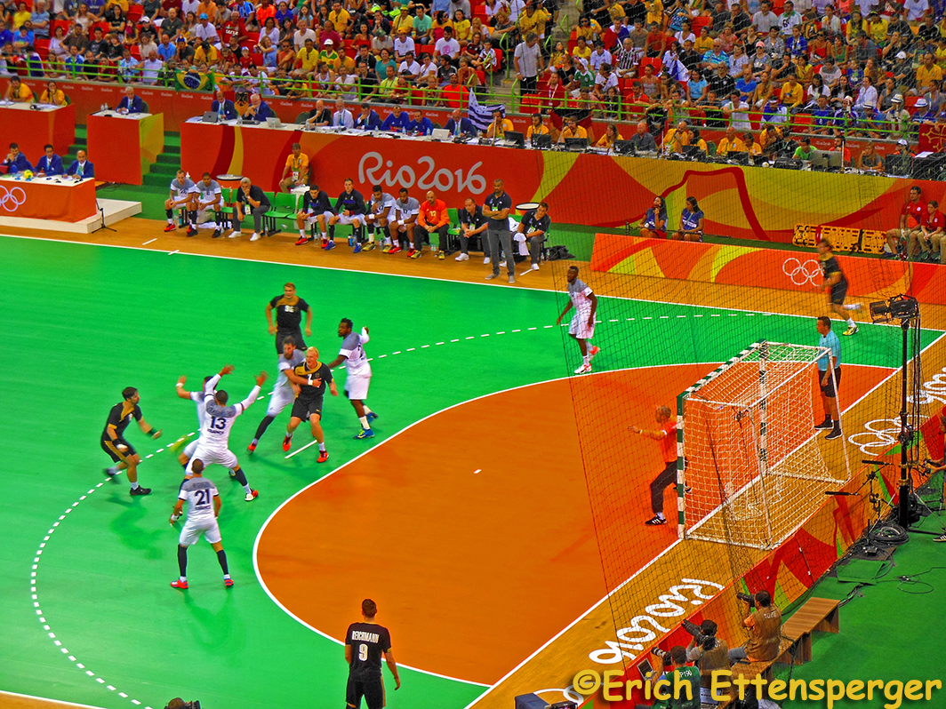
Vou contar um pouco da minha experiência no Rio de Janeiro durante a realização dos Jogos Olímpicos de Verão 2016. É o segundo grande evento que participo (o outro foi a Copa do Mundo de Futebol de 2014 – assisti a 3 jogos, mas isso é assunto para outra postagem). Inicialmente fiquei temerosa em viajar para o Rio, tive medo de um ataque terrorista (antes do evento só se falava disso), da capacidade de organização e planejamento de grandes eventos no Brasil e de aglomerações de pessoas. Apesar disso, Erich e Stefano (filho de Erich) foram assistir uma semifinal de handball e eu fui ver a classificatória de ginástica rítmica.
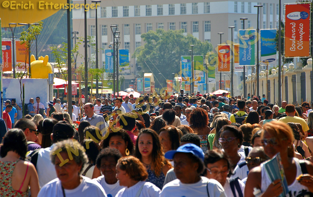
A chegada no Rio, no dia 16 de agosto foi tranquila (independente de eventos, dica: não compre o táxi de volta para o aeroporto junto com o táxi que você comprar na chegada no aeroporto do Galeão, é bem mais caro). Acho que foi bom não ter chegado no começo do evento quando ainda estavam ocorrendo alguns ajustes por parte da organização do evento. No dia seguinte, fomos visitar o Boulevard Olímpico. Trata-se de um trecho que vai da Praça XV até à região portuária, onde está localizado o Museu do Amanhã.
Museu do Amanhã / Museum der Zukunft / Museum of the future
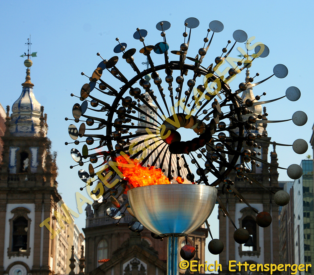
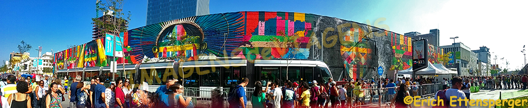
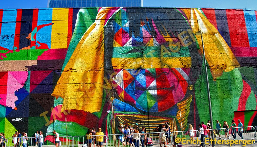
Nesse local foi implantado um projeto de recuperação urbana que tornou uma antiga área portuária abandonada em uma zona turística extremamente interessante, um dos legados das Olímpiadas. Durante o evento foram instalados grandes telões, palcos, a Casa Brasil com exposição sobre nosso país, a pira Olímpica estava acesa lá também, em frente à Igreja da Candelária, o grande mural (em torno de 3000 m2) denominado “Etnias” do artista paulistano Kobra, dentre outras atrações. Vi na televisão que quatro milhões de pessoas visitaram essa área durante o evento.
Boulevard Olímpico /Olympische Boulevard /Olympic BoulevardPira Olimpíca / Olympische Feuer /olympic fireMural Etnias / Ethnische Wand /wall EthnicitiesDetalhe do mural /Detail der Wand /Detail of the mural
No dia 18 fomos visitar as Casas Temáticas (assunto para o próximo post). Somente na sexta, dia 19, fomos ao Parque Olímpico localizado na Barra da Tijuca (veja aqui os locais das competições), complexo com cinco arenas, dois centros olímpicos, um velódromo e um estádio. Na entrada do complexo está localizado o prédio dos estúdios da Globo/Sportv. O lugar é imenso, tem 1,18 milhão de metros quadrados e os projetos arquitetônicos dos prédios são criativos e bonitos. Não gostei da praça de alimentação porque está localizada a céu aberto, se faz sol, fica quente, se chove, não tem lugar para se abrigar. Nessa praça, estava localizada o stand da Samsung e a Mega Store do evento. Para entrar na loja tinha uma fila imensa (que andava logo), tinha fila para comprar os tickets para bebidas, para comidas, para pagar com cartão de crédito, para pagar com dinheiro e para receber as comidas e bebidas. Em resumo: você saía de um fila e sem perceber já tinha entrada em outra…
Vista da praça de alimentação /Gastronomiebereich /food courtFila para entrar na Mega Store / Warteschlange vor dem Maga Store / queue to get into the Mega Store
Erich e Stefano não enfrentaram filas para entra na Arena do Futuro (eles chegaram com antecedência) e eu fiquei numa fila imensa para entrar na Arena Olímpica do Rio (não cheguei com antecedência, mas em cima da hora), mas também andava rápido. As arenas tinham muitos assentos vazios, talvez o preço dos ingressos foi salgado…
Arena carioca I, Arena do futuro e o Estádio Aquático do Parque Olímpico / Arena Carioca I, Arena der Zukunft und das Schwimmstadion im Olympia-Park / Arena Carioca I, arena of the future and the Swimming Stadium in the Olympic ParkPartida de Handball /Semifinale Handball /Semifinal HandballFila para entrar na Arena Olímpica / Warteschlange vor der Olympia Arena / queue to get into the Olympic Arena
Minha conclusão sobre participar de grandes eventos: você não deve ter medo de estar no meio de multidões, ser paciente para enfrentar longas filas e se preparar para não reclamar, afinal você foi porque quis. Quando voltei do parque olímpico para pegar o BRT de volta, avistei uma multidão esperando pelo próximo transporte e era aquela aglomeração desorganizada mesmo, tipo “entre no veículo se conseguir”. Tinha uma pessoa avisando (somente em português) que quem quisesse entrar no ônibus e seguir em pé, podia entrar…
Mas, apesar disso tudo, eu acho que valeu a pena a experiência. Eu lembro que o “clima” dentro dos ginásios era emocionante, presenciei isso quando a ginasta brasileira fez a apresentação.
Acho que o Brasil foi muito corajoso em realizar o evento, considerando-se que é um país que não costuma trabalhar com planejamento a longo prazo e finalizar obras com antecedência (a linha 4 do metro ficou pronta uma semana antes do evento). Mas, acho que no final, quase que todo mundo que participou desse evento gostou muito porque o Rio é realmente uma cidade linda e o nosso povo, definitivamente é muito simpático e acolhedor! Agora vamos ver como serão os Jogos Paralímpicos, que serão realizados entre 7 a 18 de setembro.
Olympische Spiele: meine Erfahrung bei einem großen Event
Ich werde ein wenig über meine Erfahrungen in Rio de Janeiro während den Olympischen Sommerspielen 2016 sprechen. Es ist das zweite große Ereignis, an dem ich teilnehmen konnte, das andere war die Fußball-Weltmeisterschaft 2014. Anfangs hatte ich Angst nach Rio zu reisen, ich hatte Angst vor einem Terroranschlag bei solch einer Großveranstaltung in Brasilien und den Menschenmassen. Trotzdem beobachteten Erich und Stefano (Sohn von Erich) das Semifinale im Handball zwischen der BRD und Frankreich und ich sah die Finalqualifikation in der Rhythmischen Sportgymnastik.
Die Ankunft in Rio am 16. August verlief ruhig, ich glaube, es war gut, nicht zu Beginn der Olympiade gekommen zu sein als noch etliche organisatorische Anpassungskorrekturen durchgeführt werden mussten.
Am ersten Tag besuchten wir den Olympischen Boulevard. Dies ist eine Passage, die vom Platz Praça XV zum Hafen führt, wo sich das „Museum der Zukunft“ befindet.
Museu do Amanhã / Museum der Zukunft / Museum of the future
Es handelt sich hierbei um ein Stadterneuerungsprojekt, das ein altes Hafenareal in einen äußerst interessanten touristischen Bereich verwandelte, eines der Vermächtnisse dieser Olympischen Spiele. Während der Olympiade sind dort riesige Bildschirme und Bühnen installiert, das Haus „Casa Brasilien“ wartet mit einer Exposition über unser Land auf, das Olympische Feuer dort leuchtet vor der Candelaria-Kirche und die große Wand (ca. 3000 m2) mit dem Namen “ethnische Gruppen” des Künstlers Kobra aus Sao Paulo ist schlichtweg spektakulär, dies nur einige Attraktionen unter anderen. 4 Millionen Personen besuchten diesen Bereich während der Olympiade.
Boulevard Olímpico /Olympische Boulevard /Olympic BoulevardPira Olimpíca / Olympische Feuer /olympic fireMural Etnias / Ethnische Wand /wall EthnicitiesDetalhe do mural /Detail der Wand /Detail of the mural
Am 18. August besuchten wir dann die „Thematischen Häuser“ (siehe nächsten Post), am Freitag den 19. August fuhren wir dann zum Olympiapark in Barra da Tijuca (hier die Standorte der Wettbewerbe sehen), ein Komplex mit fünf Arenen, zwei Olympiazentren, einem Velodrom und einem Stadion. Im Eingangsbereich befinden sich auch die Fernsehstudios von Globo/sportv. Der Park ist riesig, verfügt über 1,18 Millionen Quadratmetern und die architektonischen Entwürfe der Gebäude sind kreativ und schön. Der Gastronomiebereich gefiel mir nicht so sehr, ganz im Freien, bei Sonnenschein viel zu heiß, wenn es regnet gibt es keinerlei Schutz davor. An diesem riesigen Platz befinden sich auch der Samsung-Stand und der Mega Store. Hier bildeten sich überall lange Warteschlangen, z.B. um den Laden zu betreten, um Tickets zu kaufen für Getränke, für Speisen, zum Bezahlen mit Kreditkarte oder mit Bargeld und dann natürlich auch, um die jeweiligen Speisen und Getränke schließlich in Empfang zu nehmen. Kurz gesagt: man gerät, ob man will oder nicht und ohne vorherige Ankündigung, von einer Warteschlange in eine nächste usw. usw…..!!!
Vista da praça de alimentação /Gastronomiebereich /food courtFila para entrar na Mega Store / Warteschlange vor dem Maga Store / queue to get into the Mega Store
Erich und Stefano hatten (da frühzeitig dran) keine Warteschlange vor der „Arena der Zukunft“, ich war in einer riesigen Warteschlange, um die „Rio-Olympic-Arena“ zu betreten. In meiner Arena waren viele leere Sitze, vielleicht der Tribut für die gesalzenen Eintrittspreise…?!
Arena carioca I, Arena do futuro e o Estádio Aquático do Parque Olímpico / Arena Carioca I, Arena der Zukunft und das Schwimmstadion im Olympia-Park / Arena Carioca I, arena of the future and the Swimming Stadium in the Olympic ParkPartida de Handball /Semifinale Handball /Semifinal HandballFila para entrar na Arena Olímpica / Warteschlange vor der Olympia Arena / queue to get into the Olympic Arena
Mein Fazit über die Teilnahme an Großveranstaltungen: man sollte keine Angst davor haben, in der Mitte von Menschenmassen zu sein, man sollte geduldig sein mit den langen Warteschlangen, man sollte sich nicht beschweren wollen, handelt es sich ja schließlich doch um das alles, was man anfänglich anvisierte.
Als ich vom Olympia Park zurückkam, um den BRT (Schnellbustransfer zur Metro) zu nehmen, sah ich eine riesige Menschenmenge auf den nächsten Transport wartend, es war eine total unorganisierte Agglomeration von Menschen im Stile von: “Steigen Sie ein in den Bus, falls Sie das können…!!“ Eine Person (nur auf portugiesisch) gab Hinweise, dass jeder, der in den Bus wolle und dann stehen möge, das doch dann versuchen könne!!
Aber trotz alledem, ich glaube, es war die Erfahrung wert. Ich erinnere mich sehr an die aufregende „Atmosphäre“ in der Halle, gerade auch diese emotionale Stimmung wenn brasilianische Athleten ihre Präsentationen machten.
Ich denke, Brasilien war sehr tapfer und mutig bei der Realisierung dieses Mega-Events, v.a. wenn man bedenkt, daß es ein Land ist, das in der Regel nicht so sehr für langfristige Planungen und Fertigstellung von Projekten mit Antizipation bekannt ist (die neue U-Bahn-Linie 4 z.B. wurde gerade einmal eine Woche vor der Veranstaltung fertiggestellt). Aber ich denke, daß es am Ende jedem, der die Olympiade besucht hat, gefallen hat, weil Rio ja wirklich eine sehr sehr schöne Stadt ist und unsere Leute jedenfalls sehr freundlich und einladend sind! Nun wollen wir sehen, wie die Paralympischen Spiele sein werden, die vom 7. bis 18. September stattfinden werden.
Olympics: my experience at a major event
I’ll talk a little about my experiences in Rio de Janeiro during the Summer Olympic Games 2016. It is the second major event in which I took part, the other was the FIFA World Cup 2014. At first I was afraid to travel to Rio, I was afraid of a terrorist attack at such a big event in Brazil and these all crowds. Nevertheless Erich and Stefano (son of Erich) saw a semi-final in handball and I saw the final qualification in the rhythmic sports gymnastics.
The arrival in Rio on August 16 passed quietly, I think it was good not to come at the beginning of the Olympics as quite a few organizational adaptation corrections had to be done.
On the first day we visited the Olympic Boulevard. This is a passage that leads from Praça XV to the port where the “Museum of the Future” is located.
Museu do Amanhã / Museum der Zukunft / Museum of the future
This is an urban renewal project that transformed an old harbor area in a very interesting tourist area, one of the legacies of these Olympics. During the Olympics there were giant screens and platforms installed, the house “Casa Brasil” was waiting with an exhibition about our country, the Olympic flame was lit there in front of the Candelaria church and the Great Wall (about 3000 m2) with the name ” ethnic groups ” of the artist Cobra from Sao Paulo is simply spectacular, these are just some of the attractions among others. 4 million people visited this area during the Olympics.
Boulevard Olímpico /Olympische Boulevard /Olympic BoulevardPira Olimpíca / Olympische Feuer /olympic fireMural Etnias / Ethnische Wand /wall EthnicitiesDetalhe do mural /Detail der Wand /Detail of the mural
On August 18 we visited the “Thematic houses” (see next post), on Friday then we drove to the Olympic Park in Barra da Tijuca (here the locations of the competitions see ), a complex of five arenas, two Olympic centers, a velodrome and a stadium. At the entrance area there are also the television studios of Globo / SporTV. The park is huge, has 1.18 million square meters, and the architectural designs of the buildings are creative and beautiful. The food court I did not like so much, all outdoors, in sunshine it is too hot, when it rains there is no protection against it. There are also the Samsung booth and the Mega Store located. Here everywhere were long queues, for example to enter to the store, to buy tickets for drinks, for meals, for paying with credit card or with cash, and then of course finally, to receive your ordered and paid food and drinks. In short: you get, like it or not, and without notice, from one queue into the next and so on and so on…!!!
Vista da praça de alimentação /Gastronomiebereich /food courtFila para entrar na Mega Store / Warteschlange vor dem Maga Store / queue to get into the Mega Store
Erich and Stefano had (since early off) no queue in front of the “arena of the future”, I was in a huge queue to enter the “Rio Olympic Arena”. In my Arena were a lot of empty seats, perhaps the tribute for the salted admission prices …?!
Arena carioca I, Arena do futuro e o Estádio Aquático do Parque Olímpico / Arena Carioca I, Arena der Zukunft und das Schwimmstadion im Olympia-Park / Arena Carioca I, arena of the future and the Swimming Stadium in the Olympic ParkPartida de Handball /Semifinale Handball /Semifinal HandballFila para entrar na Arena Olímpica / Warteschlange vor der Olympia Arena / queue to get into the Olympic Arena
My conclusions for a participation in suuuuuch major events: you should not be afraid to be in the middle of big crowds, you should be patient with the long queues, you should not want to complain as it is indeed finally the thing you aimed for initially.
When I came back from the Olympic Park to take the BRT (Quick bus transfer to the metro), I saw a huge crowd waiting for the next transport, it was a totally disorganized agglomeration of people in the style of: “Get on the bus, if you can … !! “A person (only in Portuguese) was advicing, that anyone who wants to get on the bus and then standing in it might still try this… !!
But in spite of everything, I think it was a worthfile experience. I remember the very exciting “atmosphere” in the arenas and especially the very emotional mood when brazilian athlets made their presentations.
I think Brazil was very brave and courageous in realizing this Mega-Event considering that it is a country that is not so well known for long-term planning and completion of projects with good anticipation (the new metro line 4 was just finished a week before the event).
But I think that in the end everyone who had participated in the Olympics liked it, because Rio is really a very beautiful city and our people are definetely very friendly and welcoming!
Now let’s see how the Paralympic Games will be, which will take place from 7 to 18 September.
Existem alguns aspectos que precisamos ter em mente quando vamos viajar, principalmente, se for um deslocamento internacional. Depois de já ter feito curtas, médias e longas viagens, cheguei à conclusão que sempre devo ter em mente alguns aspectos e de levar algumas coisinhas que ajudam bastante em caso de necessidade. Vou apresentar minha lista, talvez você possa criar sua própria lista ou acrescentar algo nessa relação.
Antes de relacionar os itens que considero importantes, vou contar o que aconteceu comigo da última vez que estive em Buenos Aires: a calça jeans de Erich descosturou em um lugar visível e ele queria usá-la para ir a um determinado passeio porque ela era mais “quente” que as outras que ele havia levado na viagem. Estávamos hospedados em um hotel próximo a Calle Rosada. A situação era simples, tinha apenas que costurar o local. Eu que sempre viajo com agulha e linha, dessa vez, nãotinha levado. Bom, então, resolvemos perguntar a alguém na rua onde teria um local nas proximidades onde pudéssemos fazer aquele reparo. Sim, conseguimos o endereço. Deixamos a calça com a promessa que estaria pronta no mesmo dia, à tarde. Que bom! Na hora determinada, voltamos para buscar a calça, que não estava pronta com a alegação que a costureira tinha recebido uma encomenda mais urgente que a nossa. Recebemos a calça, porém, ela continuava descosturada. Então, resolvemos perguntar onde poderíamos comprar agulha e linha (hum, como dizer agulha em espanhol? Lembre-se que você não tem wi-fi em todos os centros urbanos, por isso, não se pode usar o tradutor eletrônico). Alguém nos informou sobre uma loja com produtos chineses. Lá fomos nós em outra direção e depois de perguntar de novo, chegamos na loja onde compramos o material. Voltamos para o hotel e costurei a calça manualmente, mas perdemos um bom tempo com esse probleminha. Resumo do relato: agulha e linha é uma dupla que devemos levar em uma viagem. Agora a lista:
Agulha e linha;
Remédio para pequenas “indisposições”, como: dor de cabeça, diarreia, ferimento leve, machucados, resfriado, dentre outros;
Se você toma algum remédio de uso contínuo, é bom levar a receita médica do mesmo, atualizada;
Adaptadores para tomadas (antes de viajar, verifique qual é o tipo de tomada elétrica usada no país do seu destino);
Sapatos confortáveis (aqueles já usados, que você tem certeza que são confortáveis, não leve novo);
Carregadores de bateria do telefone, de câmaras, enfim de equipamentos eletrônicos
Endereços que você precisa saber no país que você vai visitar;
Informar aos seus familiares endereços e telefones dos hotéis, além de informar onde e quando ficará hospedado neles;
Cópia do passaporte para ter na bolsa e deixar o original no cofre do hotel;
Carteira de motorista para quem vai alugar carro. Uma boa ideia é ter seus documentos escaneados e guardados na nuvem ou no seu e-mail;
Lista de lugares que você quer conhecer nas cidades visitadas (para não ter que ficar procurando quando chegar lá – mas, tem também aquelas pessoas que querem descobrir o lugar, então aí é outra proposta de viagem – Erich e eu já viajamos para conhecer determinados lugares, que já sabemos inclusive como chegar lá e qual é a melhor época do ano para visita-los. Não adianta querer ver os campos de lavanda da Provence e ir na época errada, quando não tem flores);
Lista de lugares e atrativos que você não deve visitar nas cidades visitadas, simplesmente por uma questão de segurança ou porque está fechado naquela época do ano devido outro tipo de problema;
Seguro de saúde de viagem e bagagem;
Carteira Internacional de Vacinação com as vacinas certas em dia, caso tais vacinas sejam exigidas para visitar certo destino;
Ter em mente que uma viagem de férias é para você relaxar e voltar renovado(a) para continuar seu trabalho, de estudos ou simplesmente sua vida no seu lar doce lar.
Gostaria de dizer que antecipei a publicação deste post porque estou viajando para o Rio de Janeiro onde vou ver a final de Ginástica Rítmica e Erich vai assistir a semi-final do handball masculino. Espero que tenha preparado minha bagagem de forma completa e que não tenha esquecido nada importante…risos…
p.s.: no próximo post vou contar um pouco do que vi no Rio durante as Olímpiadas.
Cunha e Zenilda: se preparando para o próximo destino!/ Cunha und Zenilda: Vorbereitung auf das nächste Reiseziel!/ Cunha and Zenilda: preparing for the next destination!
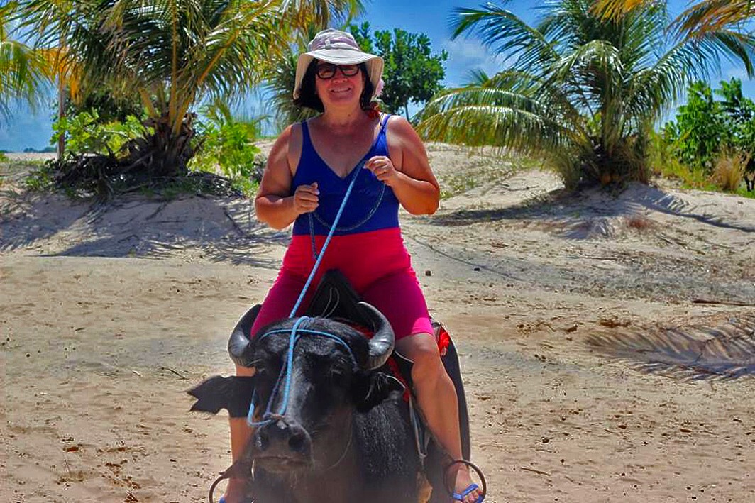
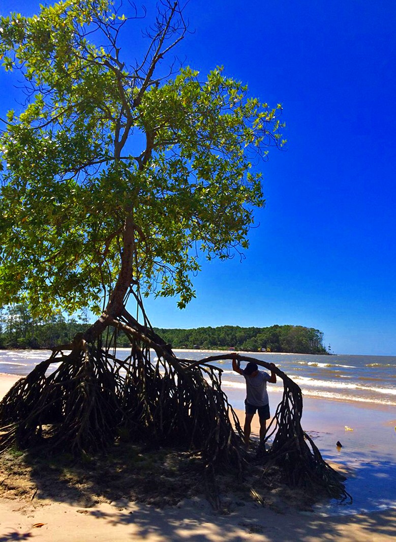
Soure, a Pérola do Marajó, localizada no extremo norte do Pará, na foz do Rio Amazonas, distante 87 km de Belém, faz parte do Marajó, a maior ilha flúviomarítima do mundo com seus 40.100km2, onde cabe, com sobra, a Bélgica. Considerada a capital informal do Marajó, Soure é uma cidade com muitas peculiaridades, a começar pela livre circulação de búfalos pelas suas ruas. Animal que pode ser visto puxando carroças e nas fazendas fazendo os trabalhos de tração. Eles são utilizados, também, nos passeios dos turistas. Quem não tiver coragem de andar sozinho, pode, apenas, montar o animal e tirar a tradicional foto comprovando o feito. O leite, o queijo e o filé de búfalo são especiarias da culinária local.
Turista corajosa e um búfalo/Mutige Touristin auf Büffel/ Courageous tourist on a buffalo
De Belém para Soure, há duas opções. O barco catamarã, que transporta também carros e parte de Icoaraci, gastando 4 horas no percurso e não ancora em Soure, terminando a viagem em Salvaterra, distante 35 km de Soure, e a lancha, mais rápido e confortável, com serviço de bar e lanchonete, ar condicionado, banheiros, TV e wi-fi de boa qualidade, gastando apenas duas horas para fazer o trajeto até Soure, não parando em Salvaterra. A viagem, pelas baias de Guajará e do Marajó, é deslumbrante. Um mar de água doce.
Quem visita Soure, não pode deixar de conhecer a praia do Pesqueiro, com dunas que se espalham em quase toda a sua extensão e, principalmente, a praia de Barra Velha, emoldurada com as árvores de raízes aéreas, que mais parecem terem crescido invertidas, tal a quantidade de ramificações apoiadas no solo. Essas praias, com ondas, são formadas pelas águas do Amazonas e do Atlântico e, sofrem a influência da maré.
Árvores de raízes aéreas na Praia de Barra Velha/ Bäume mit Luftwurzeln am Strand Praia de Barra Velha/ Trees with aerial roots at the beach Praia de Barra Velha
A hospedagem em Soure, apesar de cara, é satisfatória. Em Soure há festividades e eventos ao longo do ano, como rodeios de búfalos e rodas de carimbó, a dança típica paraense. A cidade também comemora o Círio de Nazaré e a festa de São Pedro, que ocorre em junho, tendo como ponto alto a procissão de barcos, todos enfeitados de bandeirolas coloridas, que se enfileiram no leito do rio Paracauari, tirando a calmaria de suas águas, sem contar a tradicional bandinha acompanhada dos fiéis que carregam o mastro para ser erguido no largo da matriz. São tradições que felizmente o progresso ainda não eliminou.
Soure tem ruas largas e retas, numeradas, facilitando o deslocamento, que pode ser feito de taxi, mototaxi e até de búfalos.
Difícil não se deixar contagiar com a exuberância da natureza e o ritmo do dia a dia marajoense.
Por do sol na Ilha do Marajó/Sonnenuntergang auf der Insel Marajó/ Sunset on the island of MarajóCerâmica marajoense/ Marajoensische Keramik/ Marajoense ceramics
Soure, die Perle von Marajó
Cunha e Zenilda: se preparando para o próximo destino!/ Cunha und Zenilda: Vorbereitung auf das nächste Reiseziel!/ Cunha and Zenilda: preparing for the next destination!
Soure, die Perle von Marajó, befindet sich im äußersten Norden von Pará in der Mündung des Amazonas-Flusses, 87 km entfernt von Belem, ist es ein Teil von Marajó, eine der größten Flußinseln der Welt, mit ihren 40.100km2 entspricht sie der Größe Belgiens. Soure gilt als die informelle Hauptstadt von Marajo, eine Stadt mit vielen Besonderheiten, beginnend mit den durch die Straßen ziehenden domestizierten Büffeln. Es sind Tiere, die Karren ziehen und für die Bauernhöfe als ihre Verkehrsmittel arbeiten. Auch werden sie für Touren mit Touristen genutzt. Wer keinen Mut hat, alleine auszureiten, kann das Tier besteigen und so das traditionelle Foto machen, um zu beweisen, es getan zu haben. Folglich sind Milch, Käse und Büffel-Steak Spezialitäten der lokalen Küche.
Turista corajosa e um búfalo/Mutige Touristin auf Büffel/ Courageous tourist on a buffalo
Von Belém nach Soure gibt es zwei Möglichkeiten. Zum einen der Katamaran, der auch Autos transportiert und in Icoaraci startet, die Strecke in 4 Stunden bewältigt, und die Reise endet nicht in Soure, sondern in Salvaterra, 35 km entfernt von Soure. Zum anderen das Boot, schneller und bequemer, mit Bar-Service und Snack-Bar, Klimaanlage, Bad, TV und guter WI-FI Qualität. Die Reise nach Soure dauert hier nur zwei Stunden ohne Stop in Salva. Die Reise, die Buchten von Guajará und Marajó, ist atemberaubend. Ein Meer von Süßwasser.
Als Besucher in Soure können Sie sich nicht den Strand „Praia do Pesqueiro“ entgehen lassen mit Dünen fast entlang seiner gesamten Länge und vor allem den Strand von „Barra Velha“ eingerahmt von Bäumen mit Luftwurzeln , die aussehen, wie wenn sie falsch herum gewachsen wären mit einer Unzahl von Zweigen vom Boden her abgestützt. Diese Strände mit Wellen von den Gewässern des Amazonas und des Atlantik hervorgerufen, unterliegen dem Einfluss der Gezeiten.
Árvores de raízes aéreas na Praia de Barra Velha/ Bäume mit Luftwurzeln am Strand Praia de Barra Velha/ Trees with aerial roots at the beach Praia de Barra Velha
Die Unterkünfte in Soure, wenn auch teuer, sind zufrieden- stellend. In Soure gibt es Feste und Veranstaltungen das ganze Jahr über mit Büffel-Rodeos und den „Carimbó Rädern“, dem typischen Tanz in Para. Die Stadt feiert auch das Fest „Nazareth Cirio“ und das Fest des heiligen Petrus, die im Juni stattfinden mit dem Höhepunkt einer Prozession von Booten, alle dekoriert mit farbigen Fahnen. Die Prozession folgt dem Flussbett des Paracauari mit seinen ruhigen Gewässern, nicht zu vergessen die traditionelle kleine Musikband, welche die Gläubigen begleitet, erwähnenswert hier auch die Masten, die in einer quadratischen Matrixform errichtet sind. Diese Traditionen sind zum Glück trotz aller Fortschritte nicht untergegangen.
Soure verfügt über breite und gerade Straßen, nummeriert, das erleichtert die Orientierung bei Fahrten mit Taxi, Mototaxi oder gar Büffel.
Es ist schwer, sich hier nicht von der Üppigkeit der Natur und dem „marajoensischen“ von Tag zu Tag Rhythmus anstecken zu lassen.
Por do sol na Ilha do Marajó/Sonnenuntergang auf der Insel Marajó/ Sunset on the island of MarajóCerâmica marajoense/ Marajoensische Keramik/ Marajoense ceramics
Soure, the Pearl of Marajó
Cunha e Zenilda: se preparando para o próximo destino!/ Cunha und Zenilda: Vorbereitung auf das nächste Reiseziel!/ Cunha and Zenilda: preparing for the next destination!
Soure, the Pearl of Marajó, is located in the far north of Pará at the mouth of the Amazon River, 87 km from Belem, it is part of Marajó, one of the largest river islands in the world, with their 40.100km2 correspond to the size Belgium. Soure is considered the informal capital of Marajo, a city with many special features, starting with the domesticated buffaloes passing through the streets. There are animals that pull carts and work for the farms as their means of transport. Also they are used for tours with tourists. Who no courage to ride out alone can mount the animal and make the traditional photo, to prove that they have done it. Consequently, milk, cheese and buffalo steak are specialties of the local cuisine.
Turista corajosa e um búfalo/Mutige Touristin auf Büffel/ Courageous tourist on a buffalo
From Belém to Soure there are two possibilities. First, the catamaran, which also transports cars and start in Icoaraci, masters the route in 4 hours, and the journey does not end in Soure, but in Salvaterra, 35 km from Soure. Secondly, the boat, faster and more convenient, with bar service and snack bar, air conditioning, bathroom, TV and good WI-FI quality. The trip to Soure takes only two hours without stop in Salva. The journey, the bays of Guajará and Marajó is staggering. A sea of fresh water.
Árvores de raízes aéreas na Praia de Barra Velha/ Bäume mit Luftwurzeln am Strand Praia de Barra Velha/ Trees with aerial roots at the beach Praia de Barra Velha
As a visitor in Soure you can not miss the beach “Praia do Pesqueiro” with dunes almost along its entire length and especially the beach of “Barra Velha” framed by trees with aerial roots that look as if they were grown upside supported with a myriad of branches from the ground. These beaches with waves of the waters of the Amazon and the Atlantic are subject to the influence of the tides.
The accommodations in Soure, although expensive, are satisfactory. In Soure there are festivals and events throughout the year with Buffalo rodeos and the “Carimbó wheels”, the typical dance at Para. The city also celebrates the feast “Nazareth Cirio” and the feast of St. Peter, which take place in June with the culmination of a procession of boats, each decorated with colored flags. The procession follows the riverbed of Paracauari with its calm waters, not forgetting the traditional small music band that accompanies the faithful, worth mentioning here also the masts, which are built in a square matrix shape. These all traditions, despite all progress not perished fortunately.
Soure has wide and straight roads, numbered, which facilitates orientation when traveling by taxi, mototaxi or even buffalo.
It’s hard not to be infected here from the lushness of nature and the ” marajoense ” day to day rhythm.
Por do sol na Ilha do Marajó/Sonnenuntergang auf der Insel Marajó/ Sunset on the island of MarajóCerâmica marajoense/ Marajoensische Keramik/ Marajoense ceramics
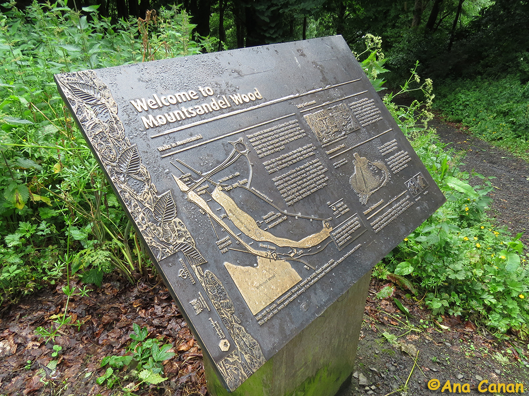
Estamos em Coleraine há cerca de 88 quilometros de Belfast, a maior cidade da Irlanda do Norte. Mountsandel Wood fica a aproximadamente dez minutos de caminhada daqui da casa de Bruce, na Avenida Nursery.
A floresta é também o mais antigo registro da presença do homem na Irlanda, entre 7900 e 7400 a.C. Sítio arqueológico onde ferramentas foram encontradas indicando marcas da Idade da Pedra, assim como um forte do tempo dos Normandos, Mountsandel encanta pela beleza natural assim como pela riqueza de informação que é possível apreender ao visitar esse destino não obrigatoriamente turístico mas provavelmente o resultado de uma estada mais prolongada, conduzidos pelas mãos de algum morador da região, como no meu caso.
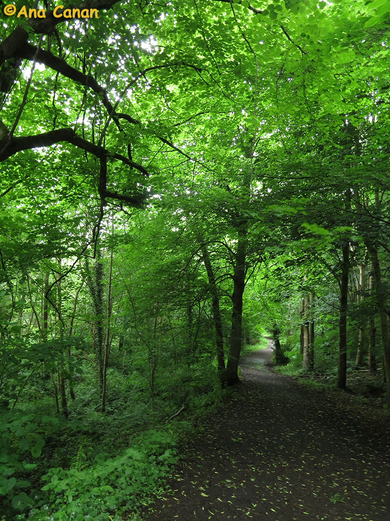
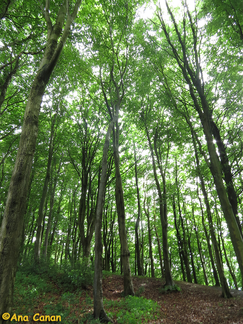
As margens do Rio Bann, o verde, como podemos ver nas fotos, é exuberante em toda a área e precisamos de algum tempo para começar a diferenciar as inúmeras tonalidades da vegetação e ver tudo com mais nitidez. Inicialmente a experiência nos faz acreditar que estamos dentro de um mar verde, sem maiores detalhes. Paciência e paixão por fotografia ajudam a ver melhor que um visitante comum, esse lugar especial.
Der Wald Mountsandel Wood – ein grünes Meer in Irland
Ana e Bruce
Text und fotos: Ana Canan
Wir sind in Coleraine, etwa 88 Kilometer (von der Hauptstadt) von Belfast entfernt, der größten Stadt in Nordirland. Der Wald Mountsandel Wood ist etwa zehn Minuten zu Fuß entfernt von Bruce´s Haus in der Nursery Avenue.
Der Mischwald belegt durch früheste Aufzeichnungen die Anwesenheit des Menschen in Irland zwischen 7600 und 7900 vor Christus. Ein archäologischer Fundort zeigt Befunde aus der Steinzeit, eine Befestigungsanlage belegt die Anwesenheit der Normannen. Mountsandel verzaubert durch natürliche Schönheit sowie die Fülle von Informationen. Durch einen längeren Aufenthalt und durch die Mithilfe eines Einheimischen wie in meinem Falle kann vieles mehr über diese Region gelernt werden.
Auch die Ufer des Flusses „Bann“, so wie wir es auf den Fotos sehen können, so grün und üppig wie die ganze Gegend, und wir brauchen etwas Zeit, um die vielen Schattierungen der Vegetation unterscheiden und alles klar sehen zu können. Zunächst macht uns die Erfahrung glauben, dass wir uns in einem grünen Meer befinden ohne weitere jegliche Details. Die Geduld und Leidenschaft für die Fotografie helfen jedoch sehr, diesen besonderen Ort besser zu sehen als ein gewöhnlicher Besucher.
Here we are in Coleraine about 55 miles from Belfast, the chief city of Northern Ireland. Mountsandel Wood is about 10 minutes by foot from Bruce’s house at Nursery Avenue.
Theseancientwoodscontain some oftheoldestrecordsof man’s history in Irelanddatingfrombetween 7,900 and 7,400 BC. ThesitewherearchaeologicalremainsincludingStone Age toolswerefoundhere is immediatelyadjacenttheremnantsof a Normanfort. Thoughfilledwith natural beautyandthoserelicsofhistoricalIreland, Mountsandel Wood is a smallarea and consequenlyrarelyrecommended to touristsbut well-worth a visitfromanyoneon a longerstay, especiallyifguidedby a local resident as in my case.
ThebanksoftheRiverBann are socrowdedwithsomanydifferentkindsof foliage—as shown in the photos—that ittakes a while to distinguishthedifferentshadesofgreen. Atfirst it seems as ifonewereafloat in a greenseabeforetheshapeandsizeofthetreesandbusheswhichformthisimpressioncanbemadeout more clearly. A passion for photographyandthepatientattention to detailcertainlyhelp to setthevisitorapartfromtheordinarytourist in thisenchantingplace!
Budapeste é a capital da Hungria localizada às margens do rio Danúbio.Com cerca de 1,7 milhões de habitantes, Budapeste não é apenas a maior cidade da Hungria, mas também semelhante em tamanho e em comparação com Viena e Praga. Estas cidades têm uma grande variedade comparável de atrações e também tem a mesma bela arquitetura.
Dentre as atrações de Budapeste, pode-se citar o famoso edifício do Parlamento, o terceiro maior do mundo, a Ópera Estatal, o Castelo de Buda e a Praça dos Heróis. Além disso, a montanha Gellert é um destino atraente para os turistas e locais, uma vez que oferece uma vista fabulosa. Desfrutar de um cruzeiro pelo rio Danúbio vale muito a pena, pois existem muitos atrativos que estão localizados nas margens desse rio e além disso, um passeio pelo rio oferece uma vista para as várias pontes de Budapeste, sendo a mais famosa, o “Chain Bridge”.
Budapeste tem muitos teatros, cinemas e museus, que fazem o coração dos amantes de cultura bater mais rápido. Há também muitas lojas, restaurantes e bares. Não deixe de visitar o mercado municipal no centro, um paraíso cheio de iguarias húngaras como a sopa goulash, goulash, páprica, salames, além do famoso Tokaj, um dos vinhos mais significativos e tradicionais do mundo. Outra atração são Termas Szechenyi, uma das maiores da Europa.
Como outra alternativa, você pode visitar o spa localizado no hotel Gellert. Ele é muito bem decorado com móveis Art Nouveau, mosaicos artísticos, vitrais e esculturas.
Cerca de 20 km de Budapeste, vale a pena visitar a pequena cidade pitoresca de Szentendre.
Quem se encantou com a beleza de Budapeste e tem tempo, não esqueça de visitar Praga e Viena. Não só por causa dos pontos turísticos ricos semelhantes, mas também por causa das curtas distâncias entre elas, é ideal aproveitar a viagem e visita-las. Uma experiência única, uma visita a Budapeste, Viena e Praga, em uma viagem, as capitais de três países …
Edificio do Parlamento Hungáro/Ungarischen Parlamentsgebäude/Hungarian Parliament BuildingGrande Mercado/Große Markthalle/Great Market HallLoja de produtos típicos/Geschäft für lokale Produkte/Shop for local productsTeto de uma das belas salas do hotel Gellért /Decke des schönen Hotelzimmer Gellért/Ceiling of the beautiful hotel rooms GellértUma das escadas rolantes mais longas do mundo/Eine der längsten Rolltreppe der Welt/One of the longest escalators in the worldCastelo Bud/Buda Burg/Buda Castle
Budapest eine Donaumetropole
Fotos: Erich Ettensperger
Die Donaumetropole Budapest ist die Hauptstadt Ungarns. Mit knapp 1,7 Millionen Einwohnern ist Budapest nicht nur die größte Stadt Ungarns, sondern auch ähnlich groß im Vergleich zu Wien und Prag. Diese Städte haben auch ein vergleichbar großartiges Angebot an Sehenswürdigkeiten und haben zudem die gleiche wunderschöne Architektur.
Zu den größten Sehenswürdigkeiten Budapests zählen u.a. das berühmte Parlamentsgebäude, das drittgrößte weltweit, die Staatsoper, der Burgpalast und der Heldenplatz. Des Weiteren ist der Gellertberg in Budapest ein attraktives Ausflugsziel für Touristen und Einheimische, da dieser ein fabelhaftes Panorama bietet. Das Donauufer ist ebenfalls eine Besichtigung wert, da an diesem einige sehr lohnenswerte Sehenswürdigkeiten gelegen sind und zugleich einen Blick auf die verschiedenen Brücken Budapests gewährt, die berühmteste hierbei die „Kettenbrücke“. Eine Bootsfahrt entlang der Donau bietet wunderschöne Ausblicke.
Budapest ist sehr reich an Theatern, Lichtspielhäusern und Museen, welche die Herzen eines jeden Kulturbegeisterten höherschlagen lassen. Ebenfalls bietet Budapest zahlreiche Einkaufsmöglichkeiten, Restaurants und Bars. Verpassen Sie es nicht, die Markthalle im Zentrum zu besuchen, ein Paradies voll mit ungarischen Köstlichkeiten, voran Paprika, Zwiebeln, Salami, Gulaschsuppe, Gulasch und der berühmte Tokajer, einer der bedeutenden und traditionsreichen Weine der Welt. Empfehlenswert auch die Szechenyi Thermen zu den größten in Europa zählend. Oder besuchen Sie alternativ das Spa im berühmten Hotel Gellert. Es ist sehr schön mit Jugendstil-Möbeln, künstlerischen Mosaiken, Glasfenstern und Skulpturen dekoriert.
Etwa 20 km von Budapest lohnt es sich, das kleine malerische Städtchen Szentendre zu besuchen.
Wer sich von der Schönheit Budapests verzaubern lässt und genügend Zeit mitbringt, sollte unbedingt auch Prag und Wien besuchen. Nicht nur aufgrund der ähnlich reichhaltigen Sehenswürdigkeiten, sondern auch wegen der geringen Entfernungen voneinander lassen sich ein Besuch von Budapest, Wien und Prag gut miteinander verbinden und zu einem einzigartigen Erlebnis werden lassen. Eine Reise und die Hauptstädte dreier Länder auf einen Schlag…!!
Edificio do Parlamento Hungáro/Ungarischen Parlamentsgebäude/Hungarian Parliament BuildingGrande Mercado/Große Markthalle/Great Market HallLoja de produtos típicos/Geschäft für lokale Produkte/Shop for local productsTeto de uma das belas salas do hotel Gellért /Decke des schönen Hotelzimmer Gellért/Ceiling of the beautiful hotel rooms GellértUma das escadas rolantes mais longas do mundo/Eine der längsten Rolltreppe der Welt/One of the longest escalators in the worldCastelo Bud/Buda Burg/Buda Castle
Budapest – a city on the Danube river banks
Photos: Erich Ettensperger
The Danube metropolis Budapest is the capital of Hungary. With nearly 1.7 million inhabitants, Budapest is not only the largest city in Hungary, but also similar in size compared to Vienna and Prague. These cities have a comparable great range of attractions and also have the same beautiful architecture.
One of the biggest attractions of Budapest include the famous Parliament building, the third largest worldwide, the State Opera, the Buda Castle and the Heroes’ Square. Furthermore, the Gellert hill in Budapest is an attractive destination for tourists and locals, as it offers a fabulous panorama. The Danube is also a visit worth, because there are some very worthwhile attractions located and also offers a view onto the various bridges of Budapest, the most famous one, the “Chain Bridge”. Whenever possible enjoy a river cruise on the Danube.
Budapest is full of theaters, cinemas and museums, which make the heart of every culture enthusiasts beat faster. Also Budapest has lots of shops, restaurants and bars. Do not miss to visit the market hall in the center, a paradise full of Hungarian delicacies, the worldfamous red paprika, salami sausages, goulash soup, goulash and the famous Tokaj, one of the very significant and traditional wines of the world. Recommended to visit the Szechenyi Thermal Baths one of the largest in Europe. Or alternatively you visit the Spa in the famous hotel Gellert. It is very well decorated with Art Nouveau furnishings, artistic mosaics, stained glass windows and sculptures.
About 20 km from Budapest, it is worthwhile to visit the small picturesque town of Szentendre.
Who can be enchanted by the beauty of Budapest and brings plenty of time not forget to visit Prague and Vienna. Not only because of the similar rich sights, but also because of the short distances between them it is ideal to combine them. A unique experience, a visit to Budapest, Vienna and Prague in one journey, the capitals of three countries … !!
If you would like to read more about Budapest, click here.
Edificio do Parlamento Hungáro/Ungarischen Parlamentsgebäude/Hungarian Parliament BuildingGrande Mercado/Große Markthalle/Great Market HallLoja de produtos típicos/Geschäft für lokale Produkte/Shop for local productsTeto de uma das belas salas do hotel Gellért /Decke des schönen Hotelzimmer Gellért/Ceiling of the beautiful hotel rooms GellértUma das escadas rolantes mais longas do mundo/Eine der längsten Rolltreppe der Welt/One of the longest escalators in the worldCastelo Bud/Buda Burg/Buda Castle
Texto e fotos: Márcia Bezerra*, viajante convidada, do blog “A Itália com Márcia”, consultora e assistente turística privada na Itália.
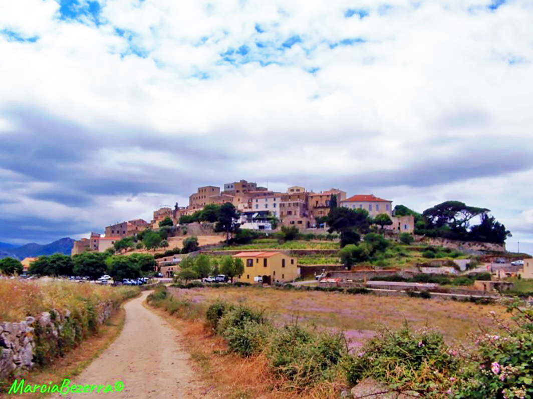
A Córsega é uma ilha localizada no meio do Mediterrâneo, na parte oeste da Itália. Entre o mar e a montanha, é autêntica, incomum e surpreendente. A sua geologia deu origem a um patrimônio natural excepcional, rica em contrastes, incomuns e selvagens. Com praias paradisíacas incontaminadas com um mar transparente e cristalino que fazem deste destino um lugar ideal para uma férias relaxante e cultural onde você vai descobrir um patrimônio excepcional e uma rica história de antigas tradições.
Terra natal de Napoleão Bonaparte que, apesar disso, não é motivo de orgulho para os corsos uma vez que o mesmo lutou junto a França na invasão da ilha que foi incorporada ao território francês em 1768. Os córsicos são muitos orgulhos das suas origens, o idioma oficial é o francês mas, conservam até hoje o dialeto corso, dialeto italiano da antiga república marítima de Gênova.
Observando o seu ambiente você será capaz de entender a sua história através das construções: românicas e barrocas, além das 67 torres genovesas cravejadas na sua costa. Mas, a ilha é um lugar para se explorar porque se seu litoral é lindo, o seu interior é fantástico. Você vai se deparar com burgos encantadores que junto com a natureza criaram um cenário quase mágico e divino. O melhor modo para se conhecer a ilha é alugar um carro e percorrer-la permanecendo no norte, no centro-oeste e depois no sul pois, apesar das distancias não serem longas, as estradas são sinuosas e, em grande parte, duplo senso aumentando o tempo do percurso entre as regiões tornando inviável a viagem tipo “bate e volta” para as distancias mais longas.
A ilha é muito procurada pelos amantes dos esporte onde se é possível praticar: trekking, ciclismo, golf, velejar, windsurf, kitesurf,diving, cavalo, motociclismo e até mesmo esquiar, surpreso né? É um lugar ideal para os amantes de esportes radicais mas, principalmente, para relaxar porque aqui o ritmo é outro, no stress.
Lugares que você não pode deixar de conhecer: as falésias e as praias de “Bonifacio”; os burgos de “Cap Corse” com as suas torres genovesas; Calvi, L’Ile Rousse os burgos de: S. Antonino, Pigna, Lama, Nonza e, logico, saborear a culinária local decisivamente mediterrânea a base peixes e frutos do mar, não deixe de provar a bouillarbasse (sopa de peixe) , como também, a base de carnes: prisutto, figatellu (salsicha de fígado ao vinho), lonzu (filé de porco), salame de Quenza, vale a pena visitar uma charcuteira para degustar estes produtos.
Você pode chegar a ilha com avião, a ilha possui 4 aeroportos localizados no norte,centro e sul, ou com barco a partir da Costa Azul (sul da França) ou a partir da Itália pelas cidades de Gênova e Savona, na região da ligúria, ou do Porto de Livorno (na região da Toscana) onde o percurso é menor. O barco é uma excelente opção pois, permite de viajar já com o carro.
Tenho certeza que você vai se apaixonar pela Córsega! Boa Viagem!!
Praia da zona de L’Ile Rousse / Strand von L’Ile Rousse / beach area of L’Ile RousseCidade fortificada de Calvi / Festungsstadt Calvi / fortified town of CalviVista panoramica de Calvi / Panoramablick auf Calvi / panoramic view of CalviBurgo de Pigna /Gemeinde Pigna / village PignaVista panoramica com seus contrastes /Panorama und seine Kontraste / panoramic view with its contrastsBurgo de St. Antonino / Gemeinde St. Antonio / village St. AntonioVista panoramica da ilha / Panoramablick auf die Insel / panoramic view of the island.
* Onde encontrar Márcia: https://www.facebook.com/estounaitalia/
blog: https://estounaitalia.com/ e Instagram? @estounaitalia
Márcia Bezerra
Korsika – eine Perle im Mittelmeer
Text und fotos: Márcia Bezerra*, Gast Reisenden, der Blog “A Itália com Márcia”, Berater und privaten Tourismusassistent in Italien.
Korsika ist eine Insel im Mittelmeer, im westlichen Teil von Italien gelegen. Zwischen dem Meer und den Bergen ist es authentisch, ungewöhnlich und überraschend. Seine Geologie macht es zu einem außergewöhnlichen Naturerbe, kontrastreich, ungewöhnlich und wild. Mit unberührten paradiesischen Stränden, mit einem transparenten und kristallklarem Meer ist dieses Reiseziel ein idealer Ort für einen erholsamen Urlaub, um ein außergewöhnliches Erbe von Kultur, reicher Geschichte und alten Traditionen zu entdecken.
Korsika, obschon Geburtsort von Napoleon Bonaparte, ist dennoch nicht Quelle des Stolzes für die Korsen, da es nach Kampf um die Insel und Invasion durch Frankreich 1768 in das französiche Territorium integriert wurde. Die Korsen sind sehr stolz auf ihre Herkunft, Amtssprache ist Französisch, aber bis zum heutigen Tag haben sie den korsischen Dialekt, einen italienischer Dialekt der alten Seerepublik Genua beibehalten.
Ein Blick auf die Gebäude lassen Sie die Geschichte dahinter erahnen: Romanik und Barock, dazu die 67 Genuesertürme prägen die Küste. Aber die Insel lädt ein zum Erkunden, denn ist seine Küste schon schön, dann ist das Inselinnere einfach fantastisch. Sie werden charmante Gemeinden auffinden, die zusammen mit der Natur ein fast magische und göttliche Szenario schaffen.
Der beste Weg, um die Insel zu erleben, ist es, ein Auto zu mieten und zunächst den Norden, den mittleren Westen und dann den Süden zu erkunden, denn obwohl die Entfernungen nicht groß sind, die Straßen sind schmal und kurvig und erhöhen im doppelten Sinn die Fahrtzeit zwischen einzelnen Regionen. “Hin und Zurück” an einem Tag lohnt sich also nicht für längere Strecken.
Die Insel ist sehr begehrt von Liebhabern sportlicher Aktivitäten wie: Reiten, Radfahren, Golf, Segeln, Windsurfen, Kitesurfen, Tauchen, Motorrad- und sogar Skifahren, überraschend, oder? Es ist ein idealer Ort nicht nur für Liebhaber von Extremsportarten, sondern eignet sich auch vor allem zum Entspannen, weil hier das Tempo ein anderes ist, kein Stress.
Orte, die Sie sich nicht entgehen lassen sollten: die Klippen und die Strände von “Bonifacio”; die Gemeinden “Cap Corse” mit seinen Genuesertürmen; Calvi, L’Ile Rousse, die Gemeinden S. Antonino, Pigna, Lama, Nonza und logisch, testen und schmecken Sie die lokale Küche des Mittelmeeres basierend auf Fisch und Meeresfrüchten, Sie sollten unbedingt die bouillarbasse (Fischsuppe) probieren, aber auch alles auf Fleischbasis: prisutto, Figatellu (Leberwurst in Wein) Lonzu (Schweinelende), Quenza Salami, es lohnt sich einen Wurststand zu besuchen, um all diese Produkte zu probieren.
Sie können die Insel mit dem Flugzeug erreichen, die Insel verfügt über vier Flughäfen im Norden, Zentrum und im Süden, aber auch oder per Schiff von Südfrankreich oder von Italien aus von Genua und Savona in Ligurien oder vom Hafen von Livorno (Toskana), von wo aus die Strecke erheblich kürzer ist. Die Fähre ist eine ausgezeichnete Alternative, da sie so mit dem eigenen Wagen anreisen.
Ich bin sicher, dass Sie Korsika lieben lernen werden! Gute Reise !
Praia da zona de L’Ile Rousse / Strand von L’Ile Rousse / beach area of L’Ile RousseCidade fortificada de Calvi / Festungsstadt Calvi / fortified town of CalviVista panoramica de Calvi / Panoramablick auf Calvi / panoramic view of CalviBurgo de Pigna /Gemeinde Pigna / village PignaVista panoramica com seus contrastes /Panorama und seine Kontraste / panoramic view with its contrastsBurgo de St. Antonino / Gemeinde St. Antonio / village St. AntonioVista panoramica da ilha / Panoramablick auf die Insel / panoramic view of the island.
*Wo finden Sie Marcia : https://www.facebook.com/estounaitalia/
blog: https://estounaitalia.com/ e Instagram? @estounaitalia
Márcia Bezerra
Corsica – a pearl of the Mediterranean Sea
Text and photos: Marcia Bezerra *, guest traveler, the blog “A Itália com Márcia”, consultant and private tourist assistant in Italy.
Corsica is an island in the Mediterranean, located in the western part of Italy. Between the sea and the mountains, it is authentic, unusual and surprising. Its geology makes it an exceptional natural heritage, rich in contrast, unusual and wild. With unspoilt paradisiacal beaches, with a transparent and crystal clear sea this destination is an ideal place for a relaxing holiday to discover an exceptional heritage of culture, rich history and ancient traditions.
Corsica, birthplace of Napoleon Bonaparte though, still is not source of pride for the Corsicans, as it was integrated into the french territory to fight for the island, and invasion by France 1768. The Corsicans are very proud of their origins, the official language is French, but to this day they have maintained the Corsican dialect, an Italian dialect of the ancient Republic of Genoa.
A view of the building gives an idea about the story behind: Romanesque and Baroque, also the 67 Genoese towers characterize the coast. But the island invites you to explore, as its coast is already beautiful, then the interior of the island is just fantastic. There are charming towns that create together with nature an almost magical and divine scenario.
The best way to experience the island is to rent a car and initially exploring the North, the Midwest and the South. Even the distances are not great, the roads are narrow and winding and increase and duplicate the travel time between regions. “There and back” in one day is not worthfile it for longer distances.
The island is highly sought after by lovers of sporting activities such as horse riding, cycling, golf, sailing, windsurfing, kite surfing, diving, motorcycle and even skiing, surprisingly, right? It is an ideal place not only for lovers of extreme sports, but is also especially to relax, because here the pace is another, no stress.
Places that you should not miss: the cliffs and beaches of “Bonifacio”; the community “Cap Corse” with its “Genuesa Towers”; visit Calvi, Ile Rousse, the churches S. Antonino, Pigna, Lama, Nonza and not forget to taste the local cuisine of the Mediterranean based on fish and shellfish, you should definitely try the bouillarbasse (fish soup), but also everything meat-based: prisutto, Figatellu (liver sausage in wine) Lonzu (pork loin), Quenza salami, it’s worth it to visit a sausage stand to taste all these products.
You can reach the island by plane, the island has four airports in the north, center and south, but also by boat from the south of France or Italy from Genoa and Savona in Liguria or from the port of Livorno (Tuscany), from where the distance is considerably shorter. The ferry is an excellent alternative as you arrive there with your own car.
I am sure that you will learn to love Corsica! Have a nice Trip !!
Praia da zona de L’Ile Rousse / Strand von L’Ile Rousse / beach area of L’Ile RousseCidade fortificada de Calvi / Festungsstadt Calvi / fortified town of CalviVista panoramica de Calvi / Panoramablick auf Calvi / panoramic view of CalviBurgo de Pigna /Gemeinde Pigna / village PignaVista panoramica com seus contrastes /Panorama und seine Kontraste / panoramic view with its contrastsBurgo de St. Antonino / Gemeinde St. Antonio / village St. AntonioVista panoramica da ilha / Panoramablick auf die Insel / panoramic view of the island.
*Where to find Márcia: https://www.facebook.com/estounaitalia/
blog: https://estounaitalia.com/ e Instagram? @estounaitalia
Apresentar lugares visitados ao redor do mundo e proporcionar um intercâmbio de informações com nossos visitantes./Display places visited around the world and provide an exchange of information with our visitors./Weltweit besuchte Orte vorstellen und einen Informationsaustausch mit unseren Besuchern anregen.