Os Estados Unidos da América é um país rico em atrações turísticas diversificadas como atrativos naturais, cidades vibrantes, museus incríveis, além de tantas outras belezas que atraem milhões de brasileiros, entre eles eu. Para entrar nesse belo país, os brasileiros precisam obter um visto.
Famosa ponte em São FranciscoSão Francisco
Hoje vou contar minha experiência sobre obter o visto para os Estados Unidos. O primeiro passo a ser dado é visitar o site da Embaixada e Consulados desse país no Brasil, onde parte das informações estão escritas em português, é um site interativo onde o sistema vai lhe conduzindo até chegar ao formulário para preenchimento dos dados, em inglês. Se você falar inglês, melhor ainda, caso contrário, você vai precisar do Google Tradutor ou de alguém que lhe ajude.
Nesse momento, recomendo que faça tudo com tranquilidade e honestidade. Depois de finalizado o preenchimento e paga a taxa (R$ 528,00 – U$ 160,00), o site vai lhe informar que você precisa agendar uma entrevista, coleta de digitais e captação de fotos. O site vai lhe fornecer uma página de confirmação, que significa que está confirmada a submissão da solicitação de um visto de não imigrante, no meu caso, um visto de turista. No próprio site, há um link que vai lhe direcionar para a página do Centro de Atendimento ao Solicitante de Visto – CASV onde você vai agendar a entrevista e a coleta de digitais e foto.
No meu caso, precisei ir à Recife, sede do Consulado que atende às pessoas da Região Nordeste do Brasil.
A entrevista e a captação de fotos acontecem em dois lugares diferentes. Há pessoas que preferem agendar tudo na mesma manhã. Sim, é possível, você agenda a visita ao CASV bem cedo e então há tempo para ir ao Consulado. No meu caso, como gosto de fazer tudo com tranquilidade, sei que Recife é uma cidade onde há congestionamentos e não conheço muito bem a cidade. Por isso decidi agendar em dois dias diferentes.
A primeira recomendação importante para essas duas ações é: se você agendou, por exemplo para as 10:15, não chegue às 9 horas. Não adianta, você vai ficar no sol, fora do prédio. Por isso, chegue com 15 minutos de antecedência mesmo, como está explicado na orientação do site. Quando cheguei no CASV, cedo, fiquei do lado de fora esperando com muitas outras pessoas. O funcionário chama os grupos de pessoas para cada horário. Aliás, os funcionários, brasileiros, são cordiais e educados. O processo de coleta de digitais e captação de fotos é bem rápido. A pessoa que me atendeu apenas me perguntou se eu já havia obtido outro visto no passado. Respondi que sim, mas há muito tempo atrás.
No dia seguinte, fui ao Consulado dos Estados Unidos para ser entrevistada. Como foi estava agendada para as 10:15 e eu sabia que não adiantava chegar muito antes, cheguei com meia hora de antecedência porque tinha trazido comigo a bagagem do hotel, pois de lá, já ia viajar de volta para Natal. Existe um posto de gasolina próximo do Consulado (passam três casas, não é vizinho) e lá existe uma loja de conveniência. Erich e eu ficamos lá, tomamos um café e quando faltava 5 minutos para as dez fui para o consulado. NÃO É PERMITIDO ENTRAR COM CELULAR, COM NENHUM EQUIPAMENTO ELETRÔNICO. Para facilitar minha entrada no consulado, levei apenas os documentos necessários e alguns suplementares numa pasta de plástico transparente. Fiquei poucos minutos numa fila e então fui orientada a entrar. Primeiro passei numa checagem eletrônica, como nos aeroportos. Depois, entrei na recepção e entreguei meu passaporte para uma funcionária simpática. Ela me orientou para sentar e aguardar ser chamada, ela ficou com meu passaporte. De vez em quando, um funcionário aparecia com alguns passaportes na mão e chamava uns três ou quatro nomes. Depois de alguns minutos, ele chamou meu nome. Fui orientada a ficar em uma fila no interior do prédio aguardando minha vez. Enquanto isso, fiquei assistindo um vídeo com dicas sobre a entrevista e também apresentando as belezas dos Estados Unidos. A fila andou rápido e chegou a minha vez. A entrevista é feita por um oficial americano, no meu caso, uma funcionária. Ela me perguntou rapidamente sobre os meus planos de viagem, onde eu trabalho e se eu tenho casa própria. Isso demorou uns 3 minutos, aproximadamente. Depois disso, ela disse: visto concedido. Eu agradeci e saí. O meu passaporte ficou lá e fui avisada que receberia depois de 10 dias. Foi tudo muito rápido e organizado. Dica importante para a entrevista: seja objetivo(a) com as respostas, não fale demais, responda exatamente o que lhe perguntarem e fale a verdade. Aliás, a verdade deve ser nossa companheira, sempre!
A minha conclusão sobre essa experiência é de que a obtenção de um visto para os Estados Unidos não é nada complicado, precisa-se de um pouco de tempo e tranquilidade.
Para saber a localização da Embaixada e dos Consulados no Brasil clique aqui e solicitar seu visto, clique aqui.
Vista da prisão de Alcatraz a partir de uma ladeira em São FranciscoGolden Gate
Observação: se você quiser continuar “viajando” com o nosso blog, clique no botão “seguir” localizado no canto inferior direito dessa página. Você receberá um email com um link para confirmar a assinatura desse blog (não paga nada). Quando clicar no link, você será direcionado para uma página em inglês (essa página explica o procedimento no caso de você desejar um dia parar de seguir o blog). A partir daí, você já está “seguindo” o blog.
AS PRAIAS DE SYLT: LUGAR DE SILÊNCIO E DE CONTEMPLAÇÃO DA NATUREZA – PARTE 2
O Brasil possui quase 8000 km de praias e com raras exceções, todas elas são públicas. Com base nessa consideração, imagine a minha surpresa ao chegar em Sylt e descobrir que as praias não são públicas. Funciona assim: quando você chega ao hotel, no momento do check in, você recebe cartões (um para cada hóspede), que se assemelha a um cartão de crédito. Esse cartão deve ser apresentado na portaria da praia (sim, a praia tem portaria). O porteiro escaneia o cartão antes de você entrar. Se você não tiver o cartão, então, é necessário comprar o bilhete de entrada no valor de 3,50 Euros.
Vista geral de uma das praias
As praias são muito bem estruturadas. Perto da portaria tem um banheiro público. Usei este banheiro com o propósito de observar sua higiene e fiquei estupefata com o grau de limpeza do mesmo: como é possível um banheiro localizado numa praia sem ter um único grão de areia? Só mesmo na Alemanha…
Na portaria você pode alugar cadeiras de rodas para praia, que é 100% acessível, apesar da areia, das dunas.
Cadeira de rodas especial para praia disponível na entrada
Na entrada da praia há sinalização informando se é permitida ou não a entrada de cachorros. Na saída da praia há lugar para lavar os pés, tem cesto de lixo com escovinha para tirar areia de objetos e tem saquinho de lixo para apanhar as fezes dos cachorros.
Saco plástico disponível para recolher as fezes dos cachorrosEscova disponível para tirar areia dos objetos
Você tem a opção de ir para a areia da praia caminhar a beira-mar, alugar uma cadeira de praia de vime, numerada, muito popular na Alemanha, chamada de “Strandkorb”
A típica cadeira de praiaObserve que há proteção para ventos e também gavetas para guardar objetos
Ou apenas curtir o visual da praia, sentar ao sol numa espécie de calçadão construído todo em estrutura de madeira (aliás, melhor opção para construção em dunas), como no caso específico da praia de Kampen.
O “calçadão” da praia
As pessoas visitam a praia no verão e no inverno, somente para estar junto da natureza e apreciar a beleza do mar. As praias de Sylt são lugares silenciosos, de contemplação. São lugares de paz e descanso. Não há vendedores ambulantes, cada um respeita o direito do outro de curtir a natureza.
Observação: se você quiser continuar “viajando” com o nosso blog, clique no botão “seguir” localizado no canto inferior direito dessa página. Você receberá um email com um link para confirmar a assinatura desse blog (não paga nada). Quando clicar no link, você será direcionado para uma página em inglês (essa página explica o procedimento no caso de você desejar um dia parar de seguir o blog). A partir daí, você já está “seguindo” o blog.
DIE STRÄNDE VON SYLT: STILLE UND KONTEMPLATION AUF NATUR – TEIL 2
Brasilien verfügt über 8.000 km Stränden und mit seltenen Ausnahmen sind sie alle öffentlich. Auf Grundlage dieser meiner Erfahrung kann man sich meine Überraschung vorstellen auf Sylt anzukommen und festzustellen, dass die Strände nicht öffentlich sind. Es funktioniert wie folgt: wenn Sie im Hotel ankommen erhalten Sie beim Check-In eine Strand-Karte (eine pro Gast), die einer Kreditkarte ähnelt. Diese Karte muß am Eingang zum Strand präsentiert werden (ja, der Strand hat einen Concierge). Der Portier scannt die Karte ein, bevor Sie zum Strand gehen. Falls Sie über keine Karte verfügen müssen Sie eine Eintrittskarte im Wert von 3,50 € erwerben.
Vista geral de uma das praias / Strandansicht / Overview of one of the beaches
Die Strände sind sehr gut strukturiert. In der Nähe des Concierge ist ein öffentliches Bad. Ich war überwältigt von dessen Hygiene und Sauberkeit: wie ist es möglich, ein Bad an einem Strand ohne ein einziges Sandkorn darin? Nur in Deutschland …
An der Lobby kann man auch Rollstühle für den Strand mieten, die zu 100% strandtauglich sind, trotz der Sanddünen .
Cadeira de rodas especial para praia disponível na entrada / spezieller Strand-Rollstuhl am Zugang zum Strand verfügbar / special beach wheelchair available at the entrance
Am Strandzugang findet sich auch die Information, ob das Mitbringen von Hunden gestattet ist oder nicht. Beim Strandausgang gibt es eine Möglichkeit die Füße zu waschen, eine Bürste zum Sandentfernen, einen Müllsack und Plastiktüten zum Entsorgen von Hundekot.
Saco plástico disponível para recolher as fezes dos cachorros / Plastikbeutel stehen zur Verfügung, um Hundekot zu entsorgen / Plastic bags are available to collect the feces of dogsEscova disponível para tirar areia dos objetos / Bürsten sind verfügbar, um Sand zu entfernen / Brush available to remove sand
Sie haben die Möglichkeit am Strand spazieren zu gehen oder Sie mieten einen Strandkorb , nummeriert und sehr beliebt in Deutschland.
A típica cadeira de praia / Ein typischer Strandkorb / A typical beach chairObserve que há proteção para ventos e também gavetas para guardar objetos / Beachtenwert der Windschutz und Schubladen für private Dinge / Note the wind protection and also the drawers for storing private objects
Oder Sie genießen einfach nur die Aussicht auf den Strand und das Meer, in der Sonne sitzen auf einer Art Promenade, eine Holzstruktur übrigens, die beste Wahl für den Bau auf Dünen, wie hier im speziellen Fall vom Strand Kampen.
O “calçadão” da praia / Strandpromenade / The beach promenade
Die Menschen besuchen den Strand im Sommer und Winter, nur um nah an der Natur zu sein und um die Schönheit des Meeres zu genießen. Die Strände auf Sylt sind ruhige Orte der Kontemplation. Sie sind Orte der Ruhe und Erholung. Es gibt auch keine Strand-Straßenverkäufer, die diesen Frieden stören.
Hinweis: Falls Sie unseren “Reisen” auf dem Blog folgen wollen, dann klicken Sie unten rechts einfach auf “Weiter”, Sie werden dann zukünftig automatisch informiert.
THE BEACHES OF SYLT: PLACE OF SILENCE AND CONTEMPLATION OF NATURE – PART 2
Brazil has 8,000 km of beaches and, with rare exceptions, they are all public. On the basis of this my experience you can imagine my suprise to arrive on Sylt and to recognize that the beaches are not public. It works as follows: when you arrive at the hotel, you will receive a beach card (one per guest) at the check-in which is similar to a credit card. This card must be presented at the entrance to the beach (yes, the beach has a concierge). The clerk will scan the card before you go to the beach. If you do not have a card, you must purchase an entrance ticket worth € 3.50.
Vista geral de uma das praias / Strandansicht / Overview of one of the beaches
The beaches are very well structured. Near the concierge is a public bath. I was overwhelmed by its hygiene and cleanliness: how is it possible to have a bath on a beach without a single sand grain in it? Only in Germany …
At the lobby there you can also rent wheelchairs for the beach, which are 100% suitable for the beach despite the sand dunes.
Cadeira de rodas especial para praia disponível na entrada / spezieller Strand-Rollstuhl am Zugang zum Strand verfügbar / special beach wheelchair available at the entrance
At the beach access is also the information whether dogs are allowed or not. At the beach exit there is a possibility to wash the feet, a brush for sand removal, a garbage bag and plastic bags for the disposal of dog droppings.
Saco plástico disponível para recolher as fezes dos cachorros / Plastikbeutel stehen zur Verfügung, um Hundekot zu entsorgen / Plastic bags are available to collect the feces of dogsEscova disponível para tirar areia dos objetos / Bürsten sind verfügbar, um Sand zu entfernen / Brush available to remove sand
You have the possibility to walk on the beach or you rent a beach basket, numbered and very popular in Germany, called “Strandkorb”.
A típica cadeira de praia / Ein typischer Strandkorb / A typical beach chairObserve que há proteção para ventos e também gavetas para guardar objetos / Beachtenwert der Windschutz und Schubladen für private Dinge / Note the wind protection and also the drawers for storing private objects
Or simply enjoy the view onto the beach and the sea, sitting in the sun on a kind of promenade, a wooden structure by the way, the best choice for building on dunes, as here in the special case of the beach Kampen.
O “calçadão” da praia / Strandpromenade / The beach promenade
People visit the beaches in summer and winter just to be close to nature and to enjoy the beauty of the sea. The beaches on Sylt are quiet places of contemplation. They are places of rest and relaxation. There are also no beach-street vendors that disturb this peace.
Note: If you want to follow our “Travels” on the blog, simply click on “Continue” in the lower right corner, you will be then automatically informed in the future.
Sylt integra o conjunto de ilhas Frísias do Norte da Alemanha.
A Ilha de Sylt possui cinquenta por cento de sua área protegida. A planície de maré do Mar Frísio próxima à Ilha de Sylt integrante do Parque Nacional em Schleswig-Holstein está incluído grupo de áreas que estão na lista do Patrimônio Mundial Natural da UNESCO.
A ilha possui belas dunas cobertas de vegetação, algumas com muitas flores, na primavera, e frutos. Sylt com sua beleza tranquila é o paraíso da elite alemã.
A ilha tem a forma de âncora e é ligada ao continente por uma estreita ponte por onde trafegam trens com pessoas e automóveis.
Mapa da ilha de Sylt/Karte der Insel Sylt/Map of island SyltForma de acesso dos automóveis e das pessoas / Anreiseart für Autos und Menschen / way of access for cars and persons
A maior cidade de Sylt é Westland, onde localiza-se a estação de trem, um calçadão extenso, além de uma avenida, a Friedrichstrasse, com muitas lojas e restaurantes.
A ilha possui lugares interessantes, como Kampen, área mais sofisticada com lojas de grife localizadas na Stroenway, o calçadão principal, também conhecido como “alameda do uísque”; Keitum, com suas belas casas com telhado de junco cobertos de hera;
Erich e as sofisticadas lojas de Sylt / Erich und elegante Geschäfte auf Sylt / Erich and sophisticated shops of SyltCasa típica da ilha/ typisches Haus auf der Insel / typical island house
Wenningstedt, onde existem sepulturas da Idade da Pedra e List, situada no extremo norte da ilha, com muitas lojas e restaurantes com espaços com formas especiais que protegem os visitantes do vento. Além disso, List tem também um centro ecológico com exposições sobre o Mar do Norte, o “Erlebniszentrum Naturgewalten”.
Em Salt você pode praticar windsurfe, utilizar os serviços dos spas, cavalgar, caminhar muito (tem caminhos deslumbrantes), pedalar. Se quiser também pode fazer excursões para visitar as Ilhas de Amrun e Föhr, ver as colônias de focas, caminhar pelo leito de algas, visitar Helgoland, famosa ilha onde existe um afloramento de uma rocha calcária solitária, dentre outros passeios.
Praias da ilha /Strände /BeachesBelo cenário/schöne Landschaft /beautiful settingBarcos de vela na praia/klleine Segelboote am Strand/small sail boats at the beach
Enfim, pode-se afirmar que Sylt é um bom exemplo da exploração turística sustentável, onde o turismo anda de mãos dadas com a preservação do meio ambiente.
HotelEntardecer na pria /Sonnenuntergang am Strand / Sunset at the beach
Observação: se você quiser continuar “viajando” com o nosso blog, clique no botão “seguir” localizado no canto inferior direito dessa página. Você receberá um email com um link para confirmar a assinatura desse blog (não paga nada). Quando clicar no link, você será direcionado para uma página em inglês (essa página explica o procedimento no caso de você desejar um dia parar de seguir o blog). A partir daí, você já está “seguindo” o blog.
SYLT, EINE PERLE IN DER NORDSEE – TEIL I
Sylt zählt zu den Nordfriesischen Inseln in Deutschland.
Die Insel Sylt ist zu fünfzig Prozent Umweltschutzbereich. Das Wattenmeer in der Nähe der friesischen Insel Sylt ist Teil des Nationalparks Schleswig-Holstein und aufgelistet als UNESCO-Weltnaturerbe.
Sie gilt als Umweltschutzgebiet aufgrund der Existenz seiner überwucherten Dünen mit vielen Blumen und Früchten im Frühling. Sylt mit seiner ruhigen Schönheit gilt als ein Paradies der deutschen Elite.
Die Insel hat die Form eines Ankers und ist durch eine schmale Brücke mit dem Festland verbunden, auf welcher Autoreisezüge verkehren.
Mapa da ilha de Sylt/Karte der Insel Sylt/Map of island SyltForma de acesso dos automóveis e das pessoas / Anreiseart für Autos und Menschen / way of access for cars and persons
Die größte Stadt auf Sylt ist Westerland, wo sich auch der Bahnhof befindet, eine umfangreiche Promenade und ein Boulevard, die Friedrichstraße, mit vielen Geschäften und Restaurants.
Die Insel offeriert interessante Orte wie z.B. Kampen mit anspruchsvollsten Designerläden in Stroenway, der Promenade, die auch als “Whisky-Mall” bekannt ist; Keitum besticht durch seine schöne reetgedeckten Häuser;
Erich e as sofisticadas lojas de Sylt / Erich und elegante Geschäfte auf Sylt / Erich and sophisticated shops of SyltCasa típica da ilha/ typisches Haus auf der Insel / typical island house
in Wenningstedt gibt es Gräber aus der Steinzeit und List, am nördlichen Ende der Insel, bietet viele Geschäfte und Restaurants an mit sogar speziellen Sitzmöglichkeiten im Freien, die die Besucher vor dem Wind schützen. Darüber hinaus existiert in List auch das ökologische “Erlebniszentrum Naturgewalten” mit Ausstellungen zum Thema Nordsee.
In Salz kann man windsurfen, die Angebote von Heilbädern nutzen, reiten, wandern (tolle Routen) und Rad fahren. Sie können auch Ausflüge auf die Inseln Föhr und Amrum unternehmen und Kolonien von Robben beobachten, zu Fuß auf Algenbetten marschieren oder auch Helgoland besuchen, jene Insel mit dem berühmten Kalksteinfelsen.
Belo cenário/schöne Landschaft /beautiful settingBarcos de vela na praia/klleine Segelboote am Strand/small sail boats at the beachPraias da ilha /Strände /Beaches
Letztendlich kann man sagen, dass Sylt ein gutes Beispiel für eine nachhaltige touristische Entwicklung ist, eine Insel also, wo der Tourismus Hand in Hand mit dem Schutz der Umwelt einhergeht.
HotelEntardecer na pria /Sonnenuntergang am Strand / Sunset at the beach
HINWEIS: Falls Sie das “SEGUIR (Reisen)” mit unserem Blog fortzusetzen wünschen, dann klicken Sie in der unteren rechten Ecke dieser Seite einfach auf “Weiter”. Sie erhalten dann eine E-Mail mit einem Link zur Bestätigung und Sie werden dann über jeden neuen Post des Blogs automatisch informiert.
SYLT, A PEARL IN THE NORTH SEA – PART I
Sylt is one of the North Frisian Islands in Germany.
The island of Sylt is fifty percent environmental protection area. The „Wattenmeer“(mud flat) near the Frisian island of Sylt is part of the National Park Schleswig-Holstein and listed as a UNESCO World Natural Heritage.
It is considered an environmental protection area due to the existence of its overgrown dunes with many flowers and fruits in spring. Sylt with its quiet beauty is considered a paradise of the German elite.
The island has the shape of an anchor and is connected by a narrow bridge to the mainland, on which carriage trains run.
Mapa da ilha de Sylt/Karte der Insel Sylt/Map of island SyltForma de acesso dos automóveis e das pessoas / Anreiseart für Autos und Menschen / way of access for cars and persons
The largest city on Sylt is Westerland, where the train station is located, an extensive promenade and a boulevard, the Friedrichstrasse, with many shops and restaurants.
The island offers interesting places like: Kampen with the most sophisticated designer shops in Stroenway, the promenade, also known as “Whiskey Mall”; Keitum is distinguished by its beautiful thatched houses; in Wenningstedt there are tombs from the Stone Age and List, at the northern end of the island offers many shops and restaurants with even special outdoor seating that protect visitors from the wind. In addition there is also the ecological “Erlebniszentrum Naturgewalten” (Nature Adventure Center) with exhibitions about the North Sea.
Erich e as sofisticadas lojas de Sylt / Erich und elegante Geschäfte auf Sylt / Erich and sophisticated shops of SyltCasa típica da ilha/ typisches Haus auf der Insel / typical island house
In Salt you can windsurf, use the services of medicinal baths, ride, hiking (great routes) and cycling. You can also take trips to the islands of Föhr and Amrum and observe colonies of seals, walk on algae beds or visit Helgoland, the island with the famous limestone rock.
Belo cenário/schöne Landschaft /beautiful settingBarcos de vela na praia/klleine Segelboote am Strand/small sail boats at the beachPraias da ilha /Strände /Beaches
Ultimately, one can say that Sylt is a good example of a sustainable tourism development, an island where tourism is hand in hand with the protection of the environment.
HotelEntardecer na pria /Sonnenuntergang am Strand / Sunset at the beach
NOTE: If you wish to continue the “Travel” on our blog, then click in the bottom down right corner of this page simply click “SEGUIR (FOLLOW)”. You will then receive an email with a link of confirmation and you will be automatically informed of any new post of the blog.
Texto: Marígia Mádje Tertuliano, economista, pesquisadora e amante do ciclismo
O ciclismo está de “vento em popa”, em todo o mundo! A brincadeira de criança toma proporções enormes e leva o cidadão à melhoria da qualidade de vida, a invadir a paisagem em busca de aventura, à integração com a natureza e a ganhar as ruas e as estradas, para “girar”. A atividade que, de solitária nada tem, promove a criação de grupos, que surgem nas diferentes localidades e integram diferentes perfis. Apesar de ecléticos, primam pela identidade e organização, cujas amizades construídas ultrapassam, muitas vezes, os pedais.
Eu entrei nessa brincadeira, por acaso, e comecei a desvendar a beleza, que é pedalar. Entre as minhas aventuras – na cidade ou na estrada – está a ida à João Pessoa, contra o vento, diga-se de passagem, e que me fez refletir o quanto querer é poder.
Depois de Jampa, lancei-me em outro desafio – ir à Nova Floresta/PB, minha terra, que fica a 173 km de Natal. Seriam muitos quilômetros de pura felicidade – eu, Papillon e meu amigo, Mario Rolim – estudante de engenharia elétrica, que, “quando cisma”, coloca a mochila nas costas e cria roteiros de tirar o fôlego.
Foto: Marígia Mádje
Assim, em um dia de fevereiro, imitando o Mário, coloquei o pé nos pedais e, em sua companhia, girei no asfalto. Ao longo do caminho, muitas surpresas e maravilhas escondidas – riachos, frutos exóticos e paisagens divinas, além de azeitonas roxas. A “alameda das azeitonas”, como denominei, é um lugar especial, perto de Natal, repleto de azeitoneiras centenárias, que margeiam o asfalto repleto de veículos e suas fuligens, onde bicicletas e seus condutores brigam por espaço, para verem o dia nascer feliz.
Quase em João Pessoa. Foto: Saulo Gomes
E aí, leitor, conheces algum lugar assim? Não?
Pois é! Este lugar existe e é lindo! As azeitoneiras estão lá – doces, suculentas, enormes e enfeitando a paisagem com seu cheiro e sabor inigualáveis, convivendo, harmoniosamente, à margem de um riacho, de água limpa e corrente, com os cajueiros e mangueiras, assim como as seriguelas, para saciarem a fome de ciclistas curiosos, dos andarilhos e de todos os animais daquele ecossistema.
Foto: Mário RolimFoto: Mário Rolim
À frente do meu giro, elas se debruçaram sobre o acostamento e chamaram a minha atenção, pelo bordeaux de suas frutas, caídas no chão, formando um tapete; pelo brilho de suas folhas, molhadas pelo orvalho da manhã, e pelo cheiro característico que exalavam. Elas, imediatamente, fizeram-me voltar à infância e às férias na casa do meu Vô Barreto. Tempo onde ir à casa de Dona Cidônia, comprar as frutinhas – que vinham enroladas, delicadamente, em cones de papel madeira e que faziam a alegria das crianças da cidade – era motivo de felicidade.
Foto: Mário Rolim
Enfim, poderia passar horas descrevendo as emoções que senti ao encontrá-las, mas retorno à pergunta: já descobriu onde fica essa maravilha? Não?
Pois, é! Em meio ao asfalto, quente ou frio, elas embelezam a Reta Tabajara – aonde milhares de carros se espremem, para que seus motoristas cheguem aos seus destinos, e a velocidade é um dos empecilhos, para que estes apreciem o belo. Na Reta, mais uma vez, descobri que eu e Papillon, somos unas, nos giros da vida, e que as belezas escondidas nas distâncias, a exemplo de Nova Floresta, são detalhes de um dia de pedal, que só enxerga quem entende o prazer de pedalar.
Observação: se você quiser continuar “viajando” com o nosso blog, clique no botão “seguir” localizado no canto inferior direito dessa página. Você receberá um email com um link para confirmar a assinatura desse blog (não paga nada). Quando clicar no link, você será direcionado para uma página em inglês (essa página explica o procedimento no caso de você desejar um dia parar de seguir o blog). A partir daí, você já está “seguindo” o blog.
A arquitetura foi a mais desenvolvida de todas artes, o que pode ser confirmado pelas obras monumentais como as pirâmides, palácios e templos, testemunhas de um passado grandioso.
Foi nesse país onde eu morei durante seis meses da minha vida, sendo uns meses em Cairo, outros em Luxor e Sharm el Sheikh.
Vista do Cairo / Blick auf Kairo / View of Cairo
Pude visitar as Pirâmides de Gizé várias vezes, inclusive, a Pirâmide de Queóps que faz parte da lista das Sete Maravilhas do Mundo Antigo.
As Pirâmides de Gizé ea Esfinge /Die Pyramiden von Gizeh und die Sphinx / The Pyramids of Giza and the Sphinx
Essas pirâmides integram o conjunto chamado “Mênfis e sua Necrópole: as Pirâmides de Gizé a Dashur” que integram o Patrimônio Mundial da UNESCO desde 1979.
Além da vibrante Cairo, com cerca de 8 milhões de habitantes, me impressionei com a Península do Sinai, onde escalei o Monte Moisés (2.285 m), próximo ao Monastério de Santa Catarina, área integrante do Patrimônio Mundial desde 2002. Foi em Sharm el Sheikh onde mergulhei nas fantásticas e coloridas águas do Mar Vermelho.
No Mar Vermelho, na Península do Sinai / Am Roten Meer auf der Sinai-Halbinsel / At the Red Sea on the Sinai Peninsula
No tempo em que passei no Alto Egito, em Luxor, tive a oportunidade de visitar os templos incríveis de Karnak e Luxor, do outro lado do Nilo, no Vale dos Reis, onde foram descobertos 64 túmulos da época do Antigo Egito. Eles integram o conjunto “Tebas Antiga com suas Necrópoles” a Lista do Patrimônio Mundial da UNESCO desde 1979.
Templo funerário de Hatshepsut, Luxor / Totentempel der Hatshepsut / Mortuary Temple of Hatshepsut
O tamanho das estátuas colossais de pedra nos templos em Abu Simbel me fascinaram pelas dimensões. Elas fazem parte da lista do Patrimônio Mundial da Unesco como integrantes dos “Monumentos Núbios de Abu Simbel até Philae”, também desde 1979. Aliás, esses templos somente foram preservados porque foi feito um grande remanejamento de 22 monumentos e complexos arquitetônicos para as margens do lago Nasser, situado na altura de 64 metros do lugar onde ocorreu a inundação da área com a construção da Represa de Assuã.
Colosso de pedra gigantesca em Abu Simbel / Gigantische Steinkolosse in Abu Simbel / Gigantic stone colossi in Abu Simbel
É também impressionante as viagens pelo Nilo a bordo dos barcos típicos chamados Felukas.
Felukas no Nilo perto de Assuã / Felukas auf dem Nil bei Assuan / Felukas on the Nile at AswanJogo de sombras no Nilo / Schattenspiele auf dem Nil / Shadow games on the NileIlhas de Rio em Assuã / Flußinseln bei Assuan / River Islands at Aswan
Durante este tempo no Egito, visitei vários mercados coloridos cheios de pessoas, animais, sons e cheiros, onde pude absorver toda aquela atmosfera.
Mercado típico no Alto Egito / Typischer Markt in Oberägypten / Typical market in Upper Egypt
Também cavalguei camelos. A sensação que se tem quando se passeia de camelo é de que você está a bordo de um navio navegando pelas areias do deserto.
E antes de finalizar, uma dica: não planeje sua viagem para os meses de julho e agosto, no Alto Egito é extremamente quente… !!
Observação: se você quiser continuar “viajando” com o nosso blog, clique no botão “seguir” localizado no canto inferior direito dessa página. Você receberá um email com um link para confirmar a assinatura desse blog (não paga nada). Quando clicar no link, você será direcionado para uma página em inglês (essa página explica o procedimento no caso de você desejar um dia parar de seguir o blog). A partir daí, você já está “seguindo” o blog.
Der Nil, die Wüste und steinerne Kolosse
Ägypten, das Land an den Ufern des Nil im Nordosten von Afrika gelegen zwischen dem Roten Meer, der Wüste von Libyen, Sudan und dem Mittelmeer.
Seine Architektur zeugt von monumentalen Werken wie den 4.500 Jahren alten Pyramiden, Palästen und Tempeln, Zeugen längst vergangener grandioser Epochen.
Vista do Cairo / Blick auf Kairo / View of Cairo
Es war dieses Land, wo ich insgesamt sechs Monate meines Lebens verbringen konnte. So konnte ich natürlich auch mehrere Male die Pyramiden von Gizeh besuchen und bewundern.
As Pirâmides de Gizé ea Esfinge /Die Pyramiden von Gizeh und die Sphinx / The Pyramids of Giza and the Sphinx
Sie gehören zu den sieben antiken Weltwundern und sind seit 1979 Weltkulturerbe. Neben dem pulsierenden Kairo mit seinen etwa 8 Millionen Einwohnern war es mir auch vergönnt die Sinai-Halbinsel zu besuchen und dort einerseits den Berg Moses(2.285m) in der Nähe des Katharinenklosters zu besteigen und andererseits in Sharm el Sheikh das Rote Meer und seine fantastische farbenprächtige Unterwasserwelt schnorchelnderweise zu genießen.
No Mar Vermelho, na Península do Sinai / Am Roten Meer auf der Sinai-Halbinsel / At the Red Sea on the Sinai Peninsula
Längere Zeit verbrachte ich auch in Oberägypten, v.a. in Luxor mit seinen unglaublichen Tempelanlagen wie dem Karnak-Tempel und Luxor-Tempel und auf der anderen Seite des Nils das Tal der Könige, eine Nekropole im Alten Ägypten mit bislang 64 entdeckten Gräbern.
Templo funerário de Hatshepsut, Luxor / Totentempel der Hatshepsut / Mortuary Temple of Hatshepsut
Beeindruckend sind auch Ausflüge auf dem Nil mit den typischen Felukas, den traditionellen Segelbooten.
Felukas no Nilo perto de Assuã / Felukas auf dem Nil bei Assuan / Felukas on the Nile at AswanJogo de sombras no Nilo / Schattenspiele auf dem Nil / Shadow games on the NileIlhas de Rio em Assuã / Flußinseln bei Assuan / River Islands at Aswan
In Abu Simbel beeindrucken die Größe der steinernen Kolosse dieser Felsentempel, die seit 1979 in der Weltkulturerbeliste der UNESCO sind. Beide Tempelanlagen mussten wegen des Assuan Staudammes und dem Aufstauen des Nassersees an einen höheren Standort verlegt werden.
Colosso de pedra gigantesca em Abu Simbel / Gigantische Steinkolosse in Abu Simbel / Gigantic stone colossi in Abu Simbel
Auch ließ ich es mir nicht nehmen, verschiedene farbenprächtige Märkte mit all seinen Menschen, Tieren, Geräuschen und Gerüchen zu besuchen und diese Atmosphäre in mich aufzusaugen.
Mercado típico no Alto Egito / Typischer Markt in Oberägypten / Typical market in Upper Egypt
Falls Sie schon einmal auf einem Kamel geritten sind, dann verstehen sie auch, warum man diese Fortbewegungsweise mit denen von Wüstenschiffen vergleicht.
Und ein Tipp noch: in Oberägypten wird es in den Monaten Juli und August extrem heiß…!!
Hinweis: Falls Sie unseren “Reisen” auf dem Blog folgen wollen, dann klicken Sie einfach nur auf “FOLGEN” in der unteren rechten Ecke dieser Seite. Sie werden dann automatisch über jede unserer weiteren Blog-Reisen informiert.
The Nile, the desert and stone colossi
Egypt, the country located on the banks of the Nile in the north-east of Africa between the Red Sea, the Libyan Desert, Sudan and the Mediterranean.
Its architecture bears witness to monumental works such as the 4,500-year-old pyramids, palaces and temples, witnesses of past grandiose eras.
Vista do Cairo / Blick auf Kairo / View of Cairo
It was this country where I could spend a total of six months of my life. So I could also visit the Pyramids of Giza several times.
As Pirâmides de Gizé ea Esfinge /Die Pyramiden von Gizeh und die Sphinx / The Pyramids of Giza and the Sphinx
They belong to the seven ancient wonders of the world and have been world cultural heritage since 1979. In addition to the pulsating Cairo with its about 8 million inhabitants, I was also allowed to visit the Sinai peninsula and on the one handside I could climb the Mount Moses (2.285m) near the Catherine’s monastery and on the other handside I could enjoy in Sharm el Sheikh the Red Sea and its fantastic colorful underwater world by snorkeling.
No Mar Vermelho, na Península do Sinai / Am Roten Meer auf der Sinai-Halbinsel / At the Red Sea on the Sinai Peninsula
A long time I also spent in Upper Egypt, mainly in Luxor with its incredible temples such as the Karnak Temple and Luxor Temple and on the other side of the Nile the Valley of the Kings, a necropolis in Ancient Egypt with 64 graves discovered so far.
Templo funerário de Hatshepsut,Luxor / Totentempel der Hatshepsut / Mortuary Temple of Hatshepsut
Also impressive are trips on the Nile with the typical Felukas, the traditional sailing boats.
Felukas no Nilo perto de Assuã / Felukas auf dem Nil bei Assuan / Felukas on the Nile at AswanJogo de sombras no Nilo / Schattenspiele auf dem Nil / Shadow games on the NileIlhas de Rio em Assuã / Flußinseln bei Assuan / River Islands at Aswan
In Abu Simbel impress the size of the stone colossi of these rock temples, which are since 1979 on the UNESCO World Heritage List. Both temples had to be moved to a higher location because of the Aswan dam and the accumulation of the waters oft he Nasser lake.
Colosso de pedra gigantesca em Abu Simbel / Gigantische Steinkolosse in Abu Simbel / Gigantic stone colossi in Abu Simbel
I did not allow myself to miss the visits of various colorful markets with all its people, animals, sounds and smells, and to absorb this atmosphere.
Mercado típico no Alto Egito / Typischer Markt in Oberägypten / Typical market in Upper Egypt
If you have ever ridden on a camel, you will also understand why you are comparing this mode of proceeding with those of desert ships.
And a tip still: in Upper Egypt it becomes extremely hot in the months of July and August…!!
Note: If you want to follow our “Journeys” on the Blog, just click on “FOLLOW” in the lower right corner of this page. You will then automatically be informed about each of our new Blog-Travels.
SANTUÁRIO DO BOM JESUS DO MATOSINHOS, GRANDIOSO E EMOCIONANTE
Desde quando eu era estudante de arquitetura, eu sonhava em visitar um dia o conjunto do Santuário do Bom Jesus do Matosinhos em Congonhas do Campo, Minas Gerais. Esse desejo foi realizado quando Erich e eu viajamos pelo Brasil para captar imagens para o livro 66 x Brasil.
Inicialmente, vale ressaltar que a concepção arquitetônica do Santuário do Bom Jesus do Matosinhos foi inspirada nos Santuários do Bom Jesus do Monte, em Braga e no de Nossa Senhora dos Remédios, em Lamego, Portugal, que tivemos o prazer de visitar.
Santuário do Bom Jesus do Monte, Braga, Portugal/Heiligtum Bom Jesus do Monte, Braga, Portugal/ Bom Jesus do Monte Sanctuary, Braga, PortugalSantuário de Nossa Senhora dos Remédios em Lamego, Portugal/Heiligtum Unserer Lieben Frau von Arzneien in Lamego, Portugal/Shrine of Our Lady of Remedies in Lamego, Portugal
Chegamos em Congonhas do Campo, distante aproximadamente 80 km de Belo Horizonte, numa manhã ensolarada e nos dirigimos para o Santuário.
A cidade de Congonhas do Campo a partir do santuário / Die Stadt Congonhas do Campo von der Wallfahrtskirche aus gesehen / The town of Congonhas do Campo seen from the sanctuary
A primeira impressão que tive do lugar foi a grandiosidade das esculturas dos doze profetas, executados em pedra sabão, até me emocionei ao apreciar aquela obra de arte do Aleijadinho (Antônio Francisco Lisboa – 1730 – 1814), que executou o trabalho já no final da vida e doente, como se fosse sua última tarefa.
O Profeta Ezequiel / Der Prophet Ezechiel / The Prophet EzekielProfeta Daniel / Prophet Daniel / prophet Daniel
O que me chamou a atenção de imediato foi a perfeita integração dos profetas com o conjunto edificado composto pela igreja, pelas escadarias majestosas, com o adro (grande pátio que antecede à igreja) murado e com as capelas. Aliás, acho que esse adro foi concebido e existe para enaltecer os profetas.
Vista geral do santuário /Gesamtansicht der Wallfahrtskirche /General view of the sanctuary
A construção do Santuário de Congonhas foi iniciada em 1757 e a igreja, pelo que eu pude perceber, é um dos mais significativos exemplos do barroco mineiro, seu interior é todo decorado no estilo rococó.
Além, dos profetas, da igreja e das escadarias, completam o grandioso conjunto as seis capelas que estão implantadas na subida que conduz até à igreja. Essas capelas guardam as 66 representações, em tamanho natural, em madeira de cedro dos Sete Passos da Paixão: Última Ceia, Jesus no Horto das Oliveiras, a Prisão, a Flagelação, a Coroação de Espinhos e a última, que abriga o Caminho para o Calvário e a Crucificação. Aleijandinho trabalhou com dois ajudantes para executá-las entre 1796 a 1799. Os pintores Manuel da Costa de Ataíde, o famoso Mestre Ataíde, e Francisco Xavier Carneiro completaram sua obra.
Uma das capelas dos Sete Passos da Paixão / Eine der Kapellen der sieben Stufen der Leidensgeschichte / One of the chapels of the Seven Steps of the PassionSanta Ceia /Abendmahl / Last Supper
O Santuário de Bom Jesus do Matosinhos é tombado pelo Instituto do Patrimônio Artístico e Nacional – IPHAN desde 1939 e passou a integrar a Lista dos bens tombados pela UNESCO, sendo reconhecido assim como Patrimônio Cultural Mundial em dezembro de 1985.
Acredito que se você tiver oportunidade de planejar uma viagem para Minas Gerais para conhecer a rota do Barroco Mineiro vai se encantar com tanta beleza. São muitos os bens arquitetônicos de grande valor. Eu só espero que o governo brasileiro seja consciente de suas preciosidades e que destine verba para que essas maravilhas possam resistir ao tempo.
Observação: se você quiser continuar “viajando” com o nosso blog, clique no botão “seguir” localizado no canto inferior direito dessa página. Você receberá um email com um link para confirmar a assinatura desse blog (não paga nada). Quando clicar no link, você será direcionado para uma página em inglês (essa página explica o procedimento no caso de você desejar um dia parar de seguir o blog). A partir daí, você já está “seguindo” o blog.
WALLFAHRTSORT HEILIGTUM BOM JESUS MATOSINHOS,
GROSSARTIG UND BEEINDRUCKEND
Als Student der Architektur habe ich immer davon geträumt, eines Tages den Wallfahrtsort Bom Jesus do Matosinhos in Congonhas do Campo, in Minas Gerais, zu besuchen. Dieser Wunsch wurde dann realisiert als Erich und ich in Brasilien unterwegs waren, um Fotos für das Buch „66 x Brasilien“ zu machen.
Zunächst ist es bemerkenswert, dass die architektonische Gestaltung der Wallfahrtskirche Bom Jesus do Matosinhos von den beiden Wallfahrtsstätten von Bom Jesus do Monte in Braga und der Kirche „Nossa Senhora dos Remédios“ in Lamego, beide in Portugal, inspiriert wurden. Wir hatten die Möglichkeit beide schon besuchen zu können.
Santuário do Bom Jesus do Monte, Braga, Portugal/Heiligtum Bom Jesus do Monte, Braga, Portugal/ Bom Jesus do Monte Sanctuary, Braga, PortugalSantuário de Nossa Senhora dos Remédios em Lamego, Portugal/Heiligtum Unserer Lieben Frau von Arzneien in Lamego, Portugal/Shrine of Our Lady of Remedies in Lamego, Portugal
Wir erreichten Congonhas do Campo, das etwa 80 km von Belo Horizonte entfernt gelegen ist, an einem sonnigen Morgen und wir fuhren sogleich hoch zur Wallfahrtsstätte.
A cidade de Congonhas do Campo a partir do santuário / Die Stadt Congonhas do Campo von der Wallfahrtskirche aus gesehen / The town of Congonhas do Campo seen from the sanctuary
Der erste Eindruck, den ich von dem Ort hatte, war die Ungeheuerlichkeit der Skulpturen der zwölf Propheten, allesamt in Speckstein ausgeführt. Ich war begeistert von diesem Kunstwerk von Aleijadinho (Antônio Francisco Lisboa, 1730-1814), der diese Arbeit am Ende seines Lebens, schon krank, quasi als letzte Lebensaufgabe ausführte.
O Profeta Ezequiel / Der Prophet Ezechiel / The Prophet EzekielProfeta Daniel / Prophet Daniel / prophet Daniel
Was mir sofort auffiel war die perfekte Integration der Gruppe von Propheten mit den Gebäuden der Kirche, die majestätische Treppe mit dem Kirchhof, die Mauer und die Kapellen. In der Tat, ich denke, dass der Kirchhof entworfen wurde, um die Propheten zu preisen.
Vista geral do santuário /Gesamtansicht der Wallfahrtskirche /General view of the sanctuary
Der Beginn des Baues der Wallfahrtsstätte von Congonhas war im Jahre 1757 und die Kirche ist, soweit ich das sehen konnte, eines der bedeutendsten Beispiele des Minais Gerais-Barock, der Innenraum ist komplett im Rokoko-Stil ausgeschmückt.
Darüber hinaus komplementieren die Propheten, die Kirche und die Treppe zusammen mit den sechs Kapellen, die hoch zur Kirche führen, die Gesamtkomposition der Anlage.
Diese Kapellen halten die 66 Darstellungen der sieben Stationen der Passion fest, in realer Größe und in Zedernholz: das letzte Abendmahl, Jesus im Olivenhain, die Festnahme, die Geißelung, die Dornenkrönung, der letzte Weg zum Kalvarienberg und die Kreuzigung.
Aleijandinho arbeitete mit zwei Assistenten zwischen den Jahren 1796 und 1799. Der Maler Manuel da Costa Ataíde, der berühmte Meister, und Francisco Xavier Carneiro vollendeten sein Werk.
Uma das capelas dos Sete Passos da Paixão / Eine der Kapellen der sieben Stufen der Leidensgeschichte / One of the chapels of the Seven Steps of the PassionSanta Ceia /Abendmahl / Last Supper
Das Heiligtum „Bom Jesus do Matosinhos Sanctuary“ ist seit 1939 in der Liste von IPHAN – Institut des nationalen historischen und künstlerischen Erbes/geschützt durch IPHAN.
Im Dezember 1985 dann anerkannt durch die UNESCO – Organisation der Vereinten Nationen für Bildung, Wissenschaft und Kultur / von der UNESCO als Weltkulturerbe anerkannt
Ich glaube, dass, falls Sie die Möglichkeit haben, eine Reise nach Minas Gerais zu planen, die Route des Mineiro-Barock Sie mit viel Schönheit verzaubern wird. Es gibt viele architektonische Vermächtnisse von großem Wert.
Ich hoffe nur, dass die brasilianische Regierung sich dieser seiner Kostbarkeiten bewusst ist und das Engagement und die Mittel für ihre Erhaltung bereitstellt.
Hinweis: Falls Sie unseren “Reisen” auf dem Blog folgen wollen, dann klicken Sie einfach nur auf “FOLGEN” in der unteren rechten Ecke dieser Seite. Sie werden dann automatisch über jede unserer weiteren Blog-Reisen informiert.
THE SANCTUARY BOM JESUS MATOSINHOS,
GREAT AND IMPRESSIVE
As a student of architecture I always dreamed of visiting the pilgrimage church of Bom Jesus do Matosinhos in Congonhas do Campo, Minas Gerais. This wish was finally realized when Erich and I were traveling around allover in Brazil to take photos for the book “66 x Brazil“.
First it is remarkable that the architectural design of the sanctuary of Bom Jesus do Matosinhos was inspired by the two pilgrimage sites of „Bom Jesus do Monte“ in Braga and the church “Nossa Senhora dos Remédios” in Lamego, both in Portugal. We had the pleasure to visit both already.
Santuário do Bom Jesus do Monte, Braga, Portugal/Heiligtum Bom Jesus do Monte, Braga, Portugal/ Bom Jesus do Monte Sanctuary, Braga, PortugalSantuário de Nossa Senhora dos Remédios em Lamego, Portugal/Heiligtum Unserer Lieben Frau von Arzneien in Lamego, Portugal/Shrine of Our Lady of Remedies in Lamego, Portugal
We reached Congonhas do Campo, which is located about 80 km from Belo Horizonte, on a sunny morning and we went straight up to the site.
A cidade de Congonhas do Campo a partir do santuário / Die Stadt Congonhas do Campo von der Wallfahrtskirche aus gesehen / The town of Congonhas do Campo seen from the sanctuary
The first impression I had of the place was the enormity of the sculptures of the twelve prophets, all performed in soapstone. I was thrilled to see this work of art by Aleijadinho (Antônio Francisco Lisboa, 1730-1814), who did this at the end of his life already sick, quasi his last life task.
O Profeta Ezequiel / Der Prophet Ezechiel / The Prophet EzekielProfeta Daniel / Prophet Daniel / prophet Daniel
What struck me immediately was the perfect integration of the group of prophets with the buildings of the church, the majestic staircase with the churchyard, the wall and the chapels. In fact, I think the churchyard was designed to praise the prophets.
Vista geral do santuário /Gesamtansicht der Wallfahrtskirche /General view of the sanctuary
The beginning of the construction of the Sanctuary of Congonhas was in 1757 and, as far as I could see, the church is one of the most important examples of the Minais Gerais Baroque, the interior is completely in rococo-style.
In addition, the prophets, the church and the staircase, together with the six chapels leading up to the church, complement the overall composition of the complex.
These chapels hold the 66 illustrations of the Seven Stations of the Passion, in real size and in cedar wood: The Last Supper, Jesus in the Olive Grove, the Arrest, the Flagellation, the Coronation of the Torches, the Last Way to Calvary and the Crucifixion.
Aleijandinho worked with two assistants between the years 1796 and 1799. The painter Manuel da Costa Ataíde, the famous master, and Francisco Xavier Carneiro completed his work.
Uma das capelas dos Sete Passos da Paixão / Eine der Kapellen der sieben Stufen der Leidensgeschichte / One of the chapels of the Seven Steps of the PassionSanta Ceia /Abendmahl / Last Supper
The Sanctuary “Bom Jesus do Matosinhos Sanctuary” has been on the list of IPHAN – Institute of National Historical and Artistic Heritage / Protected by IPHAN since 1939.
In December 1985 then acknowledged by the UNESCO – United Nations Educational, Scientific and Cultural Organization – as a World Cultural Heritage.
I believe that if you have the opportunity to plan a trip to Minas Gerais, the route of the Mineiro Baroque will enchant you with a lot of beauty. There are many architectural legacies of great value.
I just hope that the Brazilian government is aware of its treasures and is providing the commitment and resources for its preservation.
Note: If you want to follow our “Journeys” on the Blog, just click on “FOLLOW” in the lower right corner of this page. You will then automatically be informed about each of our new Blog-Travels.
O Chile definitivamente me encanta. É um dos países com um dos territórios mais estreitos do mundoe possui o maior Índice de Desenvolvimento Humano da America Latina. É quase nosso vizinho, apresenta diversas paisagens de tirar o folêgo. Erich e eu já visitamos o Chile várias vezes e ficamos deslumbrados com tanta beleza que já publicamos um livro sobre o Deserto do Atacama, localizado no norte. Conheci Puerto Montt porque fez parte do roteiro de um cruzeiro no qual Erich e eu participamos, a cidade é famosa devido a bela Região dos Lagos.
Puerto Montt, capital da Região de Los Lagos, é uma cidade portuária integrante da província de Lalanquihue, região dos belos lagos chilenos e está distante 1.055 km de Santiago. Tem uma população aproximada de 200 mil habitantes. Essa cidade faz limite com Puerto Varas (norte), Cochamó (leste), Calbuco (sudoeste) e Maulin e Los Muermos (oeste) e sua economia baseia-se no turismo e na exportação do salmão.
Mapa da Região dos Lagos do ChilePuerto Montt, a partir do navio
Puerto Montt é o portão de entrada para fazer passeios deslumbrantes como o de barco pelo Rio Petrohue sendo possível apreciar uma paisagem verdejante onde destaca-se o Vulcão Osorno, o Parque Nacional Vicente Pérez Rosales, o mais antigo do Chile e onde está localizado o Lago Esmeralda, com suas águas verdes e brilhantes, além dos Saltos do Rio Petrohué. Nesse parque é possível percorrer trilhas e apreciar belos saltos. O Vulcão Osorno é um caso especial de beleza cênica e é considerado o “Monte Fuji da América do Sul”.
Embarque para o passeio no lagoPaisagem verdejanteNuvens envolvem o vulcão
Além do Lago Esmeralda, existem outros famosos pelas paisagens deslumbrantes: Todos los Santos, Llanquihue e o Chloé. São vários passeios que se pode fazer na região, como por exemplo visitar o Parque Andino Alerce, as Termas de Sotomo, as Ilhas Tengo e a Chiloé e ver os pinguins, são muitas as opções.
Além dessas belezas vale a pena ressaltar a cidade de Puerto Varas, conhecida como a “Cidade das Rosas”. Ela originou-se de uma colônia de imigrantes alemães. Sugiro uma visita ao Museu Alemão e uma caminhada na Floresta Lahuen Ñadi, com belíssimos cenários. Sugiro uma caminhada pela orla do Lago Llanquihue, onde estão localizados hotéis, restaurantes, posto de informações turísticas.
Orla do Lago Lalanquihue em Puerto VarasMúsico em Puerto Varas
Enfim, o Chile é um destino que oferece várias opções ao turista e que você não precisa atravessar o oceano para chegar lá. Há voos diretos saindo de São Paulo com duração aproximada de 4 horas. Chile, definitivamente, recomendo!
Por do sol no mar, próximo a Puerto Montt
Observação: se você quiser continuar “viajando” com o nosso blog, clique no botão “seguir” localizado no canto inferior direito dessa página. Você receberá um email com um link para confirmar a assinatura desse blog (não paga nada). Quando clicar no link, você será direcionado para uma página em inglês (essa página explica o procedimento no caso de você desejar um dia parar de seguir o blog). A partir daí, você já está “seguindo” o blog.
Puerto Montt und die Seen-Region in Chile
Mir gefällt Chile auf jeden Fall. Es ist eines der längsten Länder der Welt mit einem der höchsten Indexe menschlicher Entwicklung in Lateinamerika. Es ist fast unser Nachbar (Brasilien), seine verschiedenen Landschaften sind atemberaubend. Erich und ich haben Chile mehrmals besucht und wir waren von seiner Schönheit begeistert. Wir veröffentlichten bereits ein Buch über die Atakama-Wüste, die im Norden des Landes gelegen ist.
Mapa da Região dos Lagos do Chile / Landkarte der Seen-Region in Chile / Map of the Lakes Region of ChilePuerto Montt a partir do navio / Puerto Montt vom Schiff gesehen / Puerto Montt seen from the ship
Ich kenne Puerto Montt, weil es Teil der Route einer Kreuzfahrt war, an der Erich und ich teilnahmen, die Stadt ist wegen seiner schönen Seen-Region bekannt.
Puerto Montt, Hauptstadt der Region Los Lagos, ist eine Hafenstadt der Lalanquihue Provinz, der Region der schönen chilenischen Seen und ist 1.055 Kilometer von Santiago entfernt. Sie hat eine Bevölkerung von ungefähr 200.000 Einwohnern. Die Stadt grenzt an Puerto Varas (im Norden), Cochamó (im Osten), Calbuco (im Südwesten) und Maulin und Los Muermos (im Westen) und seine Wirtschaft basiert hauptsächlich auf Tourismus und dem Export von Lachs.
Puerto Montt ist das Tor für Ausflüge zum Rio Petrohue und Schiffsausflügen. Genießen Sie üppige grüne Landschaften im Vicente Pérez Rosales Nationalpark, dem ältesten von Chile, und erleben Sie den See Esmeraldo, mit seinem hellen grünen Wassern, an welchen der berühmte Vulkan Osorno gelegen ist. Im Park können Sie umherwandern und imposante Wasserfälle bewundern. Der Vulkan Osorno ist das Highlight der landschaftlichen Schönheit und bekannt als der “Fuji Südamerikas.”
Embarque para passeio no lago / Einschiffung für Ausflug auf dem See / Embarkation for trip on the lakePaisagem verdejante / Grüne Landschaft / Green landscapeNuvens envolvem o vulcão / Wolken rund um den Vulkan / Clouds surrounding the volcano
Neben dem Esmeraldo See gibt es weitere sehr bekannte Seen, die ebenfalls durch ihre atemberaubenden Landschaften betören wie z.B. der „Todos los Santos“, „Llanquihue“ und „Chloé“.
Es gibt verschiedene erwähnenswerte Touren, die Sie in der Region unternehmen können wie z.B. der „Anden-Park Alerce“, die Sotomo Bäder, die Tengo Inseln und Chiloé mit seinen Pinguinen.
Neben diesen Schönheiten lohnt es sich, die Stadt Puerto Varas zu benennen, bekannt als die “Stadt der Rosen”. Sie entstand aus einer Kolonie deutscher Einwanderer. Machen Sie einen Besuch im Deutschen Museum und einen Spaziergang im schönen Wald „Lahuen Nadi“. Schlendern Sie auch entlang der Uferpromenade des Llanquihue-Sees, wo viele Hotels, Restaurants und die Touristeninformation gelegen sind.
Orla do Lago Lalanquihue em Puerto Varas / Uferpromenade am Lago Lalanquihue in Puerto Varas / Waterfront at Lake Llanquihue in Puerto VarasMúsico em Porto Varas / Musiker in Puerto Varas / Musician in Puerto Varas
Chile ist definitiv ein Reiseziel, das einem Touristen sehr viele Optionen bietet und dazu auch noch relativ einfach erreichbar (von Brasilien aus). Es gibt Direktflüge von Sao Paulo mit einer Dauer von ca. 4 Stunden. Chile jedenfalls ist immer eine Reise wert!
Por do sol no mar, próximo a Puerto Montt / Sonnenuntergang auf See in der Nähe von Puerto Montt / Sunset at sea, close to Puerto Montt
Hinweis: Falls Sie unseren “Reisen” auf dem Blog folgen wollen, dann klicken Sie einfach nur auf “FOLGEN” in der unteren rechten Ecke dieser Seite. Sie werden dann automatisch über jede unserer weiteren Blog-Reisen informiert.
Puerto Montt and the lakes region in Chile
I definetely like Chile. It is one of the longest countries in the world with one of the highest indexes of human development in Latin America. It is almost our neighbor (Brazil) and all its different landscapes are breathtaking.
Erich and I have visited Chile several times and we were thrilled by its beauty. We already published a book about the Atacama desert, which is located in the north of the country.
Mapa da Região dos Lagos do Chile / Landkarte der Seen-Region in Chile / Map of the Lakes Region of ChilePuerto Montt a partir do navio / Puerto Montt vom Schiff gesehen / Puerto Montt seen from the ship
I know Puerto Montt because it was part of the route of a cruise in which Erich and I participated, the city is known for its beautiful lakes-region.
Puerto Montt, capital of the „Los Lagos“ region, is a port town of the Lalanquihue province, the region of the beautiful Chilean lakes, and is located 1,055 kilometers away from Santiago. It has a population of about 200,000 inhabitants. The city is bordered by Puerto Varas (to the north), Cochamó (to the east), Calbuco (to the southwest) and Maulin and Los Muermos (to the west) and its economy is mainly based on tourism and the export of salmon.
Puerto Montt is the gateway for trips to the Rio Petrohue and boat trips. Enjoy lush green landscapes in the Vicente Pérez Rosales National Park, the oldest one of Chile, and experience the lake Esmeraldo, with its bright green waters, where the famous volcano Osorno is located. In the park you can wander around and admire impressive waterfalls. The volcano Osorno is the highlight of the scenic beauty and known as the “Fuji of South-America.”
Embarque para passeio no lago / Einschiffung für Ausflug auf dem See / Embarkation for trip on the lakePaisagem verdejante / Grüne Landschaft / Green landscapeNuvens envolvem o vulcão / Wolken rund um den Vulkan / Clouds surrounding the volcano
In addition to Lake Esmeraldo there are other well-known lakes, which are also fascinating by their breathtaking landscapes, such as the “Todos los Santos”, “Llanquihue” and “Chloé” lakes.
There are several interesting tours to undertake in the region such as: The “Andean Park Alerce”, the Sotomo Baths, the Tengo Islands and Chiloé with its penguins.
In addition to these beauties it is worth to name the city of Puerto Varas, known as the “City of Roses”. It originated from a colony of German immigrants. Take a visit to the German Museum and take a walk in the beautiful forest “Lahuen Nadi”. You can also stroll along the lakeside promenade of Llanquihue Lake where many hotels, restaurants and tourist information are located.
Orla do Lago Lalanquihue em Puerto Varas / Uferpromenade am Lago Lalanquihue in Puerto Varas / Waterfront at Lake Llanquihue in Puerto VarasMúsico em Porto Varas / Musiker in Puerto Varas / Musician in Puerto Varas
Chile is definitely a destination that offers a lot of options to a tourist and is also relatively easy to reach (from Brazil). There are direct flights from Sao Paulo with a duration of approx. 4 hours.
Chile is always worth a trip!
Por do sol no mar, próximo a Puerto Montt / Sonnenuntergang auf See in der Nähe von Puerto Montt / Sunset at sea, close to Puerto Montt
Note: If you want to follow our “Journeys” on the Blog, just click on “FOLLOW” in the lower right corner of this page. You will then automatically be informed about each of our new Blog-Travels.
Praias brancas, montanhas azuis e rochas vermelhas
Não consegui visitar as 10 atrações “top” da Austrália, porém, o que eu conheci, consegui fazer uma boa mistura de lugares e ter uma idéia geral sobre esse país. Nossa viagem nos levou para uma cidade conhecida mundialmente, vibrante, com sua famosa queima de fogos na festa de Ano Novo, para as montanhas “azuis” e para a pedra arredondada gigante e mística localizada no centro do continente.
Sydney com seus 4.5 milhões de habitantes é lembrada devido a sua ópera futurística, a ponte espetacular Harbour, uma das mais extensas do mundo e pelas suas praias (cerca de setenta), como por exemplo, as praias de Bondi e Manly. A cidade está localizada na costa leste da Austrália, banhada pelo Oceano Pacífico e fazendo limites com vários parques nacionais.
Os arranhas céus de Sydney / Skyline Sydney / Sydney skylineA mundialmente famosa “Bondi Beach” em Sydney / Der weltberühmte „Bondi Beach“ in Sydney / The world famous “Bondi Beach” in Sydney
Uma das belas regiões naturais, é o “Greater Blue Mountains Area” (Área Maior das Montanhas Azuis), localizado a 60 km oeste de Sydney e que desde o ano 2000 integra a Lista do Patrimônio Mundial da UNESCO. Você pode sentir o cheiro de muitas espécies de eucaliptos e esse ar carregado da fragância do eucalipto, juntamente com o ar das montanhas ocasiona um tom azulado nas montanhas.
As “Três Irmãs” nas Montanhas Azuis / Die „Drei Schwestern“ in den Blue Mountains / The “Three Sisters” in the Blue Mountains
Não esqueça o “must” para todos que viajam para a Austrália, a rocha de arenito gigantesca localizada no centro desse grande continente. “Uluru“ é o nome do segundo maior monolito da terra, provavelmente o mais famoso, chamado de “Ayers Rock”. É o santuário dos nativos australianos. Várias cavernas foram encontradas com pinturas aborígenes nesse lugar. O escopo deste gigante, o marco do quinto continente, possui 10 km de largura. É um lugar fantástico para assistir aos jogos de cores no nascer e / ou pôr do sol, quando os padrões de sombra parecem vagar ao longo desse enorme colosso composto de arenito.
Ayers Rock e a lua / Ayers Rock und der Mond / Ayers Rock and the moon
Outra atração impressionante para mim foi o grupo de rochas chamado “Olgas”, os quais estão localizados a apenas 30 km de Uluru.
As rochas “Olgas” e no fundo Ayers Rock / Die “Olgas” Felsformationen und im Hintergrund Ayers Rock / The “Olgas” rock formations and Ayers Rock in the background
Certamente você será capaz de ver mais cedo ou mais tarde, outro morador típico da Austrália … o canguru !!
Cangurus em ação / Kängeruh in Action / Kangaroo in action
Observação: se você quiser continuar “viajando” com o nosso blog, clique no botão “seguir” localizado no canto inferior direito dessa página. Você receberá um email com um link para confirmar a assinatura desse blog (não paga nada). Quando clicar no link, você será direcionado para uma página em inglês (essa página explica o procedimento no caso de você desejar um dia parar de seguir o blog) e então, você não precisa fazer mais nada.
Weisse Strände, blaue Berge und rote Felsen
Ich habe auf meinen Reisen nach Australien zwar nicht alle der 10 TOP-Sehenswürdigkeiten sehen dürfen, dafür aber konnte ich zumindest einen kleinen jedoch feinen Mix des Landes kennenlernen. Unsere Reise führt uns heute in eine weltbekannte, vibrierende Stadt mit seinem weltweit berühmten Silvesterfeuerwerk, in „blaue“ Berge und zu einem gigantischen, mythischen Felsbrocken im Zentrum des Kontinentes.
Sydney mit seinen 4,5 Millionen Einwohnern ist weltbekannt u.a. für seine futuristische Oper, der spektakulären Harbour-Brücke, eine der breitesten der Welt und seinen 70 Stränden, sehr bekannt sind der Bondi- und Manly-Beach. Die Stadt liegt an der Ostküste Australiens am Pazifischen Ozean und grenzt an verschiedene Nationalparks.
Os arranhas céus de Sydney / Skyline Sydney / Sydney skylineA mundialmente famosa “Bondi Beach” em Sydney / Der weltberühmte „Bondi Beach“ in Sydney / The world famous “Bondi Beach” in Sydney
Einer davon ist der „Blue Mountains Nationalpark“, 60 km westlich von Sydney gelegen und seit 2000 UNESCO-Weltkulturerbe. Man kann den Duft vieler Eukalyptusarten verspüren und genau dieser verursacht dann mit der Höhenluft der Berge dieses „blau“ anmutende Luftflimmern, der Namensgeber dieser Gebirgskette.
As “Três Irmãs” nas Montanhas Azuis / Die „Drei Schwestern“ in den Blue Mountains / The “Three Sisters” in the Blue Mountains
Nicht zu vergessen und ein „Muß“ für jeden Australienreisenden schließlich dieser gigantische Sandsteinfelsbrocken mitten im australischen Outback im Zentrum dieses riesigen Kontinentes. „Uluru“ ist der Name dieses zweitgrößten Monolithen unserer Erde, wahrscheinlich bekannter unter dem Namen „Ayers Rock“. Es ist das Heiligtum der Ureinwohner Australiens und man fand zahlreiche Höhlen mit Malereien der Aborigins. Der Umfang von 10 km belegt die Grösse dieses Giganten, dem Wahrzeichen des 5. Kontinentes. Fantastisch anzusehen die Farbenspiele bei Sonnenauf- und/oder Sonnenuntergängen, dann scheinen die Schattenmuster auf diesem riesigen Sandsteinkoloss entlang zu wandern.
Magníficos jogos de cores em Ayers Rock / Prächtige Farbenspiele am Ayers Rock / Magnificent colors at Ayers Rock
Nicht weniger beeindruckend war für mich die Felsengruppe der „Olgas“, die sich nur etwa 30 km vom Uluru befindet.
As rochas “Olgas” e no fundo Ayers Rock / Die “Olgas” Felsformationen und im Hintergrund Ayers Rock / The “Olgas” rock formations and Ayers Rock in the background
Sicherlich werden Sie auf einer Australienreise früher oder später dann auch einen weiteren typischen Bewohner sprunggewaltig zu Gesicht bekommen…das Kängeruh !!!
Cangurus em ação / Kängeruh in Action / Kangaroo in action
HINWEIS: Falls Sie das “SEGUIR (Reisen)” mit unserem Blog fortzusetzen wünschen, dann klicken Sie in der unteren rechten Ecke dieser Seite einfach auf “Weiter”. Sie erhalten dann eine E-Mail mit einem Link zur Bestätigung und Sie werden dann über jeden neuen Post des Blogs automatisch informiert.
White beaches, blue mountains and red rocks
On my travels to Australia I was not able to see all of the 10 TOP attractions, but I was able to get to know a small fine mix of this country. Our journey leads us today to a world-famous, vibrant city with its very famous New Year’s fireworks, to “blue” mountains and to a gigantic mythical boulder in the center of the continent.
Sydney with its 4.5 million inhabitants is world-known for its futuristic opera, the spectacular Harbor Bridge, one of the widest in the world, and its around 70 beaches, e.g. the Bondi and Manly Beach. The city is located at the east coast of Australia at the Pacific Ocean and borders with various national parks.
Os arranhas céus de Sydney / Skyline Sydney / Sydney skylineA mundialmente famosa “Bondi Beach” em Sydney / Der weltberühmte „Bondi Beach“ in Sydney / The world famous “Bondi Beach” in Sydney
One of them is the “Blue Mountains National Park“, 60 km west of Sydney and since 2000 UNESCO World Cultural Heritage. You can feel the smell of many eucalyptus species and precisely this causes with the mountain air this “blue” appearing air flicker, the name giver of this mountain chain.
As “Três Irmãs” nas Montanhas Azuis / Die „Drei Schwestern“ in den Blue Mountains / The “Three Sisters” in the Blue Mountains
Not to forget and a “must” for every Australia traveler, this gigantic sandstone rock in the middle of the Australian outback in the center of this huge continent. “Uluru” is the name of this second-largest monolith of our earth, probably more famous under the name “Ayers Rock”. It is the sanctuary of the aborigines of Australia and numerous caves were found with Aboriginal paintings. The scope of this giant, the landmark of the 5th continent, is 10 km wide. Fantastic to watch the color games at sunrise and / or sunsets, then the shadow patterns seem to wander along this huge sandstone colossus.
Magníficos jogos de cores em Ayers Rock / Prächtige Farbenspiele am Ayers Rock / Magnificent colors at Ayers Rock
Not less impressive for me was the rock group of “Olgas”, which is only about 30 km from Uluru.
As rochas “Olgas” e no fundo Ayers Rock / Die “Olgas” Felsformationen und im Hintergrund Ayers Rock / The “Olgas” rock formations and Ayers Rock in the background
Certainly you will be able to see sooner or later another typical resident of Australia … the kangaroo !!
Cangurus em ação / Kängeruh in Action / Kangaroo in action
NOTE: If you wish to continue the “Travel” on our blog, then click in the bottom down right corner of this page simply click “SEGUIR (FOLLOW)”. You will then receive an email with a link of confirmation and you will be automatically informed of any new post of the blog.
O tempo passa tão rápido! Percebi que já faz 20 anos que tenho o prazer de trabalhar no Parque Estadual Dunas de Natal Jornalista Luiz Maria Alves, uma área verde com 1.172 hectares circundada pelos bairros de Tirol, Nova Descoberta, Capim Macio, Ponta Negra e pela Via Costeira. Nós, natalenses, somos orgulhosos de possuir uma área verde tão rica e de tão grande relevância ambiental.
O Parque das Dunas integra a Rede Brasileira de Reservas da Biosfera da UNESCO, na categoria Mata Atlântica. Essa Unidade de Conservação, foi a primeira criada no Estado do Rio Grande do Norte e 80% de sua área é remanescente de Mata Atlântica, aquela grande floresta que foi avistada por Cabral quando ele descobriu o Brasil.
O Bosque dos Namorados é o Setor de Uso Público desse Parque e é onde eu trabalho e por isso, além dos meus colegas de trabalho, tenho também a companhia de pássaros, lagartos, aranhas, muitas árvores, flores, e também, embora raramente, de cobras, dentre outros. Todos nós convivemos em total harmonia, cada um tratando o outro com o maior respeito, afinal, a administração do Parque funciona dentro da casa deles.
O Bosque dos Namorados em um momento de silêncio/Der “Park der Liebenden” in einem Moment der Stille /The Park in a moment of silence
Essa área verde possui três trilhas que eram abertas ao público e onde era possível realmente adentrar na mata e caminhar por essas rotas conhecidas como Peroba, Ubaia Doce e Perobinha. O Bosque dos Namorados também possui uma Sala de Exposição que também era aberta ao público, nessa sala o visitante podia conhecer mais sobre as riquezas do Parque das Dunas. Esses dois atrativos estão fechados temporariamente, mas, mas, espera-se que sejam reabertos em um futuro próximo *.
As pessoas que visitam essa área podem respirar o ar puro filtrado pelas árvores. Além disso, podem escutar o canto dos muitos pássaros que estão sempre por lá como o Cancão, por exemplo, que sempre vocaliza bem alto, principalmente na hora do almoço, quando eu estou finalizando meu trabalho diário.
Cancão – Cyanocorax cyanopogon
Muitas das pessoas que visitam essa Unidade de Conservação tem o propósito de se exercitarem, de assistirem shows que acontecem no final de Semana (Som da Mata, Bosque Encena, Dançando nas Dunas) outras trazem seus filhos para brincarem no playground, alguns vão lá para namorar e apreciar a natureza, outras participam de eventos que acontecem por lá, algumas fazem piquinique.
Diversos eventos acontecem no Parque das Dunas/ Verschiedenste Veranstaltungen finden im “Parque das Dunas” statt /Different events take place in the “Parque das Dunas”
Eu, por exemplo, gosto do Bosque dos Namorados para escutar e ver os pássaros e às vezes, até fotografá-los. Dependendo da sorte de cada um, é possível encontrar os saguis, que aparecem sempre para sugar a seiva dos cajueiros ou comer frutas ou até mesmo ver um belo fungo que se esconde no tronco de uma árvore ou quem sabe ver a flor do Pau-Brasil que não tem vida longa.
Os saguis e a manga/Äffchen und eine Mango/Marmosets and sleeveFungos /Pilze /FungiA flor da árvore “Pau-brasil”/Blüten des Baumes “Pau-brasil”/ Flowers of the tree “Pau Brazil”
No mês passado, eu tive uma sorte grande: avistei uma cobra jiboia enroscada no alto de uma árvore, mas isso, é realmente muito difícil de acontecer.
Uma cobra jibóia enroscada numa árvore/Eine Schlange an einem Baum/A snake coiled in a tree
Tem as iguanas, que gostam de tomar sol nas margens do lago artificial ou mesmo nas proximidades da cerca que separa a área pública da área de mata propriamente dita. Elas sempre me lembram aqueles animais pré-históricas que vemos em filmes! São tão sérias e misteriosas!
Iguana
O Parque das Dunas foi assunto da minha dissertação de mestrado quando pude conhecê-lo melhor e confirmar sua grande importância ambiental.
São tantas as minhas impressões sobre o Parque das Dunas, mas, não devo escrever um texto tão longo para o blog, por isso, publicarei um e-book nos próximos meses onde vou contar mais sobre esse Parque, que desde tanto tempo faz parte da minha vida. Acho que cada um de nós, potiguares ou não, devemos sempre cuidar com amor e carinho dessa área, protegendo-o para que ele seja sempre o abrigo seguro para suas plantas e seus animais, além de desempenhar seu papel ambiental!
Observação: se você quiser continuar “viajando” com o nosso blog, clique no botão “seguir” localizado no canto inferior direito dessa página. Você receberá um email com um link para confirmar a assinatura desse blog (não paga nada). Quando clicar no link, você será direcionado para uma página em inglês (essa página explica o procedimento no caso de você desejar um dia parar de seguir o blog) e então, você não precisa fazer mais nada.
As falésias formadas por rochas sedimentares da Formação Barreiras/ Die Klippen von Sedimentgesteinen von Barreiras gebildet/ The cliffs formed by sedimentary rocks of Barreiras
* Após a publicação desse post, tomei conhecimento que a Sala de Exposição do Parque das Dunas reabrirá ao público, somente durante a semana a partir do dia 11 de outubro do corrente ano.
PARK DER DÜNEN: DER REICHTUM DER UMWELT IN NATAL
Die Zeit vergeht so schnell! Ich erkannte, dass es nun 20 Jahre her ist das Vergnügen haben, im „Dunas Park Journalist Luiz Maria Alves“ zu arbeiten. Es handelt sich um eine Grünfläche von 1.172 Hektar, eingerahmt von den Vierteln Tirol, Nova Descoberta, Capim Macio, Ponta Negra und der Küstenstraße Via Costeira. Wir Natalenser sind stolz, eine solche Grünfläche zu haben, so reich und von sehr großer Umweltrelevanz.
Der „Parque das Dunas“ ist Teil des brasilianischen Netzes der UNESCO-Biosphärenreservate in der Kategorie Atlantischer Regenwald.
Dieses Naturschutzgebiet wurde zum ersten Mal im Bundesstaat Rio Grande do Norte mit 80% seiner Fläche geschaffen und ist ein Überbleibsel des Atlantischen Regenwaldes, dem Urwald, der von Cabral gesichtet wurde, als er Brasilien entdeckte.
Der “Bosque dos Namorados“ (Der Wald der Verliebten) ist der Sektor der öffentlichen Nutzung dieses Parkes wo ich arbeite und meine Kollegen arbeiten in Gesellschaft mit Vögeln, Eidechsen, Spinnen, vielen Bäumen, Blumen und auch u.a., wenn auch selten, Schlangen.
O Bosque dos Namorados em um momento de silêncio/Der “Park der Liebenden” in einem Moment der Stille /The Park in a moment of silence
Wir leben alle zusammen in Harmonie (Mensch & Natur), jeder behandelt den anderen mit großem Respekt, schließlich residiert ja die Parkverwaltung innerhalb ihrer Heimat (der Natur).
Der Park verfügt über drei Wanderwege, die der Öffentlichkeit zugänglich waren und wo es tatsächlich möglich war, den atlantischen Wald zu betreten, diese Wege haben die Namen Peroba, Ubaia Doce und Perobinha.
Der „Bosque dos Namorados“ offeriert auch einen öffentlich zugänglichen Ausstellungsraum mit mehr Informationen über den Reichtum des Parkes „Parque das Dunas“. Diese beiden Attraktionen sind leider momentan vorübergehend geschlossen.
Die Besucher hier können die durch die Bäume gefilterte saubere Luft einatmen. Darüber hinaus können sie den Gesang der vielen Vögel genießen v.a. zur Mittagszeit.
Cancão – Cyanocorax cyanopogon
Viele der Menschen, die den Park besuchen, verfolgen den Zweck der Ausübung sportlicher Bewegung, andere bringen ihre Kinder zum Spielen, andere gehen dorthin, um die Natur genießen und wieder andere nehmen an anderen Veranstaltungen teil, die dort stattfinden.
Diversos eventos acontecem no Parque das Dunas/ Verschiedenste Veranstaltungen finden im “Parque das Dunas” statt /Different events take place in the “Parque das Dunas”
Ich für meinen Teil genieße es, die Vögel zu hören und zu beobachten und manchmal sogar mit Glück, sie zu fotografieren. Manchmal kann man eine Gruppe von Äffchen beobachten wie sie den Saft der Cashew-Frucht aussaugen oder Obst fressen. Sogar wunderschöne Pilze, die in dem Stamm eines Baumes eingewachsen sind oder vielleicht die Blüten des „Pau-Brasil“ Baumes, welche keine lange Lebensdauer haben, können sie eventuell sehen.
Os saguis e a manga/Äffchen und eine Mango/Marmosets and sleeveFungos /Pilze /FungiA flor da árvore “Pau-brasil”/Blüten des Baumes “Pau-brasil”/ Flowers of the tree “Pau Brazil”
Letzten Monat hatte ich das große Glück eine Schlange zusammengerollt auf einem Baum zu entdecken, aber das passiert wirklich selten.
Uma cobra jibóia enroscada numa árvore/Eine Schlange an einem Baum/A snake coiled in a tree
Es gibt auch Leguane, die sich am Ufer eines kleinen künstlichen Sees oder in der Nähe des Parkzaunes sonnen möchten. Sie erinnern mich immer an diese prähistorischen Tiere, wie wir sie aus Filmen kennen! Sie wirken so ernst und geheimnisvoll!
Iguana
Der Park „Parque das Dunas“ war das Thema meiner Dissertation, um seine große Bedeutung für unsere Umwelt in Natal zu verifizieren.
Ich habe weit mehr Berichtenswertes über den „Parque das Dunas“, aber ich möchte nicht einen zu langen Text für den Blog schreiben. Jedoch veröffentlichen wir in Kürze eine E-Buch über diesen Park, der ja einen Teil meines Lebens verkörpert. Ich denke, jeder von uns, ob Potiguar oder auch nicht, sollte sich immer mit Liebe und Sorgfalt um diesen Park kümmern, ihn schützen, so dass er immer der sichere Hafen, die Heimat für seine Pflanzen und Tiere bleiben kann!
As falésias formadas por rochas sedimentares da Formação Barreiras/ Die Klippen von Sedimentgesteinen von Barreiras gebildet/ The cliffs formed by sedimentary rocks of Barreiras
HINWEIS: Falls Sie das “SEGUIR (Reisen)” mit unserem Blog fortzusetzen wünschen, dann klicken Sie in der unteren rechten Ecke dieser Seite einfach auf “Weiter”. Sie erhalten dann eine E-Mail mit einem Link zur Bestätigung und Sie werden dann über jeden neuen Post des Blogs automatisch informiert.
THE „PARK OF DUNES“ THE WEALTH OF
THE ENVIRONMENT OF NATAL
Time passes so fast! I realized that it is now already 20 years I have the pleasure to work in the “Dunas Park Journalist Luiz Maria Alves”. It is a green area of 1,172 hectares, surrounded by the districts Tirol, Nova Descoberta, Capim Macio, Ponta Negra and the Via Costeira coastline. We Potiguares (people who live in Natal) are proud to have such a green space, so rich and of great environmental importance.
The Park “Parque das Dunas” is part of the Brazilian Network of UNESCO Biosphere Reserves in the category Atlantic Rainforest.
This reserve was created for the first time in the state of Rio Grande do Norte with 80% of its area and is a remnant of the Atlantic Forest, the forest, which was sighted by Cabral when he discovered Brazil.
The “Bosque dos Namorados” (The Forest of people in Love) is the public sector of the park where me and my colleagues work in company with birds, lizards, spiders, many trees, flowers and also, among others, even rarely, snakes.We all live together in harmony (Human beings & Nature), each treats the other with great respect, as finally we, the park management resides within the home of the nature.
O Bosque dos Namorados em um momento de silêncio/Der “Park der Liebenden” in einem Moment der Stille /The Park in a moment of silence
The park has three trails that were open to the public and where it was actually possible to enter the Atlantic forest, these routes are named Peroba, Ubaia Doce and Perobinha.
The “Bosque dos Namorados” offers also a public exhibition space with more information about the richness of the Park “Parque das Dunas”. These two attractions are currently temporarily closed.
Our visitors here can breathe the clean air filtered through the parktrees. Moreover they can enjoy the singing of many birds during lunchtime.
Cancão – Cyanocorax cyanopogon
Many of the people who visit the park, follow the purpose of performing physical exercises, others bring their children to play, others go there to enjoy nature and still others accept other events, which took place there.
Diversos eventos acontecem no Parque das Dunas/ Verschiedenste Veranstaltungen finden im “Parque das Dunas” statt /Different events take place in the “Parque das Dunas”
For my part I enjoy hearing the birds and to observe them and sometimes even with some luck, to photograph them. Sometimes you can observe a group of monkeys as they suck the juice of the cashew fruit or they eat other fruits. You might see even beautiful big fungi that are grown on the trunk of a tree, or perhaps the flowers of “Pau-Brasil” tree, which do not have a long life.
Os saguis e a manga/Äffchen und eine Mango/Marmosets and sleeveFungos /Pilze /FungiA flor da árvore “Pau-brasil”/Blüten des Baumes “Pau-brasil”/ Flowers of the tree “Pau Brazil”
Last month I had the luck to discover a snake curled up on a tree, but that happens really rarely.
Uma cobra jibóia enroscada numa árvore/Eine Schlange an einem Baum/A snake coiled in a tree
There are also iguanas, those looking for some sun on the banks of a small artificial lake or near the Park fence. They always remind me of these prehistoric animals, as we know from films! They look so serious and mysterious!
Iguana
The Park “Parque das Dunas” was the topic of my dissertation to verify its importance for our environment in Natal.
I have far more to tell about the “Parque das Dunas”, but I do not want to write a too long text for the blog. However, we soon publish an e-book about the Park, which indeed represents a part of my life.
I think each of us, whether or not Potiguar should always take care with love and care to this Park, protecting it so that it may always be a safe haven, the home for its plants and animals!
As falésias formadas por rochas sedimentares da Formação Barreiras/ Die Klippen von Sedimentgesteinen von Barreiras gebildet/ The cliffs formed by sedimentary rocks of Barreiras
NOTE: If you wish to continue the “Travel” on our blog, then click in the bottom down right corner of this page simply click “SEGUIR (FOLLOW)”. You will then receive an email with a link of confirmation and you will be automatically informed of any new post of the blog.
Viagem até o Cabo Norte na Noruega: rota espetacular!
Foi em um verão, os escandinavos, que não são tão abençoados pelo sol, chamaram de verão do século. Nós começamos a viagem com o nosso pequeno fusca, além de equipamentos para acampar ao longo do caminho sem fim até à extremidade norte da Europa.
Aproximadamente 6000 quilómetros estava à frente de nós, viajamos na direção da Noruega, pela costa, sempre rumo ao norte e na volta, retornamos via Finlândia com seus 1.000 lagos. Algumas das minhas impressões sobre esta longa jornada quero apresentar aqui. A nossa viagem foi a recompensa. Percorrer essa rota era nosso objetivo.
A excursão para o norte da Noruega/Die Tour nach Norden in Norwegen/The tour to the north in Norway
O Sol da meia noite, geleiras, neve, fiordes, O círculo Ártico, renas, montanhas, lagos, florestas, vegetação de tundra e, finalmente, o lendário Cabo Norte são os pilares desta longa jornada espetacular.
É única a sensação de dirigir depois de meia-noite através de belas paisagens, com o sol ainda brilhando e com quase nenhum tráfego e você poder ver as pessoas aparando seu gramado nesse horário ou ainda estarem sentadas com amigos no jardim desfrutando de um churrasco. Você dirige à meia-noite com se estivesse no alto das montanhas, numa altitude de 3.000 metros como nos Alpes, mas, na verdade você está apenas a 600 metros acima do nível do mar ou até menos. Sensacional! No entanto, também conheço a sensação contrária, quando há predominância da falta de luz. Uma vez estive à trabalho em Oslo e Bergen numa semana antes do Natal e foi assim: às 9 horas ainda estava escuro e frio e às 14 horas já estava escuro novamente. Meu corpo e minha mente sentiram uma sensação estranha com a falta de luz natural.
O primeiro destaque nesta viagem foi o Geirangerfjord, é um dos mais famosos fiordes da Noruega e integra, desde julho de 2005, a lista dos bens naturais do Património Mundial da UNESCO. Ele possui cerca de 15 km de comprimento com uma largura que varia entre 0,6 e 1,3 km. São impressionantes as vistas desse lugar, do alto e a partir da água.
Lofoten, um arquipélago de 80 ilhas, localizado à aproximadamente 100 a 300 km ao norte do Círculo Polar Ártico, no Oceano Atlântico, é também fascinante. Eu amei as casas coloridas e a zona campestre, fenomenal.
O próprio Cabo Norte não é tão espetacular, mas após essa longa viagem senti uma esmagadora sensação de estar no ponto mais setentrional da Europa, tendo chegado lá com nosso pequeno fusca e com o sol da meia-noite. E como eu mencionei antes, o caminho era o objetivo…!!
A viagem de regresso, em seguida, levou-nos através do Lakeland Finnish/Die Rückfahrt führte uns dann durch die Finnische Seenplatte/The return journey then led us through the Finnish LakelandGeirangerfjord: Natureza fantástica/Fantastische Natur / Fantastic natureNas montanhas, mesmo no verão, há neve/ Und in den Bergen auch im Sommer Schnee/ And in the mountains even in summer snowLofoten: Casas coloridas, o céu e o mar/Bunte Häuser, der Himmel und das Meer/Colorful houses, the sky and the seaSource: https://pt.wikipedia.org/wiki/Cabo_Norte#/media/File:Midnight_sun.jpg … e, finalmente, o sol da meia-noite no cabo norte / …und schließlich die Mitternachtssonne am Nordkap /… and finally the midnight sun at the North Cape
Impressionen auf dem Weg zum Nordkap
Es war in einem Sommer, den die Skandinavier, die ja nicht zu sehr von der Sonne verwöhnt sind, als Jahrhundertsommer bezeichneten. Wir machten uns mit unseren VW plus Ausrüstung zum Campen auf den unendlich langen Weg zum nördlichen Ende Europas.
Etwa 6.000 km lagen vor uns, wir fuhren in Norwegen immer immer weiter gen Norden und über Finnland und seine 1.000 Seen wieder gen Süden. Einige meiner Impressionen auf dieser langen Reise möchte ich hier vorstellen. Unser Weg war das Ziel.
A excursão para o norte da Noruega/Die Tour nach Norden in Norwegen/The tour to the north in Norway
Die Mitternachtssone, Gletscher, Schnee, Fjorde, der Polarkreis, Rentiere, Berge, Seen, Wälder, Tundravegetation und schließlich das legendäre Nordkap sind die Eckpunkte dieser spektakulären langen Reise.
Einzigartig das Gefühl, nach Mitternacht durch wunderschöne Landschaften zu fahren und die Sonne scheint, es ist kaum Verkehr und sie können Menschen beobachten, wie sie um diese Uhrzeit ihren Rasen mähen oder immer noch bei Tageslicht mit Freunden im Garten bei einem BBQ sitzen. Sie fahren auch um Mitternacht durch schneebedeckte Berglandschaften auf gefühlten 3.000m Höhe wie im Hochgebirge in den Alpen, tatsächlich sind es aber nur einmal 600 Meter über dem Meer oder weniger. Genial. Allerdings kenne ich auch das krasse, harte Gegenteil. Ich hatte einmal eine Woche vor Weihnachten in Oslo und Bergen zu tun und es war dann so: um 9 Uhr morgens war es immer noch dunkel und kalt, und um 14 Uhr nachmittags auch schon wieder, einfach deprimierend dieses Defizit an Tageslicht für unseren Geist und Körper!
Das erste Highlight war der Geirangerfjord, er ist einer der bekanntesten FjordeNorwegens und gehört seit Juli 2005 zum UNESCO-Weltnaturerbe, er ist etwa 15 km lang und seine Breite variiert zwischen 0,6 und 1,3 km. Unbeschreiblich die verschiedenen Ansichten sowohl von hoch oben als auch vom Wasser aus.
Sehr beeindruckend auch die Lofoten, eine Inselgruppe von 80 Inseln etwa 100 bis 300 km nördlich des Polarkreises im Atlantik gelegen. Ich war begeistert von den farbigen Häusern und der Landschaft, phänomenal.
Das Nordkap selbst ist nicht so spektakulär, aber nach der langen Reise ist es schon ein überwältigendes Gefühl am nördlichsten Punkt Europas mit unserem kleinen Volkswagen angekommen zu sein. Am Nordkap und der Mitternachtssonne. Und wie gesagt: der Weg war das Ziel…!!
A viagem de regresso, em seguida, levou-nos através do Lakeland Finnish/Die Rückfahrt führte uns dann durch die Finnische Seenplatte/The return journey then led us through the Finnish LakelandGeirangerfjord: Natureza fantástica/Fantastische Natur / Fantastic natureNas montanhas, mesmo no verão, há neve/ Und in den Bergen auch im Sommer Schnee/ And in the mountains even in summer snowLofoten: Casas coloridas, o céu e o mar/Bunte Häuser, der Himmel und das Meer/Colorful houses, the sky and the seaSource: https://pt.wikipedia.org/wiki/Cabo_Norte#/media/File:Midnight_sun.jpg … e, finalmente, o sol da meia-noite no cabo norte / …und schließlich die Mitternachtssonne am Nordkap /… and finally the midnight sun at the North Cape
Impressions on the way to North Cape
It was in a summer, the Scandinavians, who are not too much spoiled by the sun, called it the summer of the century. We started with our small VW plus equipment for camping onto this infinitely long way to the north end of Europe.
Approximately 6000 kilometers lay ahead of us, we went in Norway always always further north and in Finland and its 1,000 lakes south again. Some of my impressions on this long journey I want to present here. Our journey was the goal.
A excursão para o norte da Noruega/Die Tour nach Norden in Norwegen/The tour to the north in Norway
The midnight sun, glaciers, snow, fjords, the Arctic Circle, reindeers, mountains, lakes, forests, tundra vegetation and finally the legendary North Cape are the cornerstones of this spectacular long journey.
Uniquely, the feeling of driving after midnight through beautiful landscapes and the sun is still shining, there is hardly any traffic and you can watch people as they mow their lawn at this time or are still sitting in daylight with friends in the garden with a BBQ. You drive at midnight through snowy mountain scenery on perceived 3.000m as at high altitudes in the Alps, in fact you are on only 600 meters above sea level or even less. Brilliant. However, I also know the strong, tough contrary. I once had some work to do a week before Christmas in Oslo and Bergen, and it was like this: at 9 am it was still dark and cold, and by 2 pm already again, it was simply a very strange sensation for me this lack of natural light for my mind and body!
The first highlight on this trip was the Geirangerfjord, it is one of the most famous fjords of Norway and is since July 2005 an UNESCO World Heritage Site, it is about 15 km long and its width varies between 0.6 and 1.3 km. Very impressive the different views of both from high above and from the water.
Very impressive also the Lofoten, an archipelago of 80 islands about 100 to 300 km north of the Arctic Circle in the Atlantic Ocean. I loved the colorful houses and the countryside, phenomenal.
The North Cape itself is not that spectacular, but after the long journey there is this overwhelming feeling to be at the northernmost point of Europe. Having arrived at the North Cape and its midnight sun. And as I mentioned before, the way was the goal…!!
A viagem de regresso, em seguida, levou-nos através do Lakeland Finnish/Die Rückfahrt führte uns dann durch die Finnische Seenplatte/The return journey then led us through the Finnish LakelandGeirangerfjord: Natureza fantástica/Fantastische Natur / Fantastic natureNas montanhas, mesmo no verão, há neve/ Und in den Bergen auch im Sommer Schnee/ And in the mountains even in summer snowLofoten: Casas coloridas, o céu e o mar/Bunte Häuser, der Himmel und das Meer/Colorful houses, the sky and the seaSource: https://pt.wikipedia.org/wiki/Cabo_Norte#/media/File:Midnight_sun.jpg … e, finalmente, o sol da meia-noite no cabo norte / …und schließlich die Mitternachtssonne am Nordkap /… and finally the midnight sun at the North Cape
Apresentar lugares visitados ao redor do mundo e proporcionar um intercâmbio de informações com nossos visitantes./Display places visited around the world and provide an exchange of information with our visitors./Weltweit besuchte Orte vorstellen und einen Informationsaustausch mit unseren Besuchern anregen.


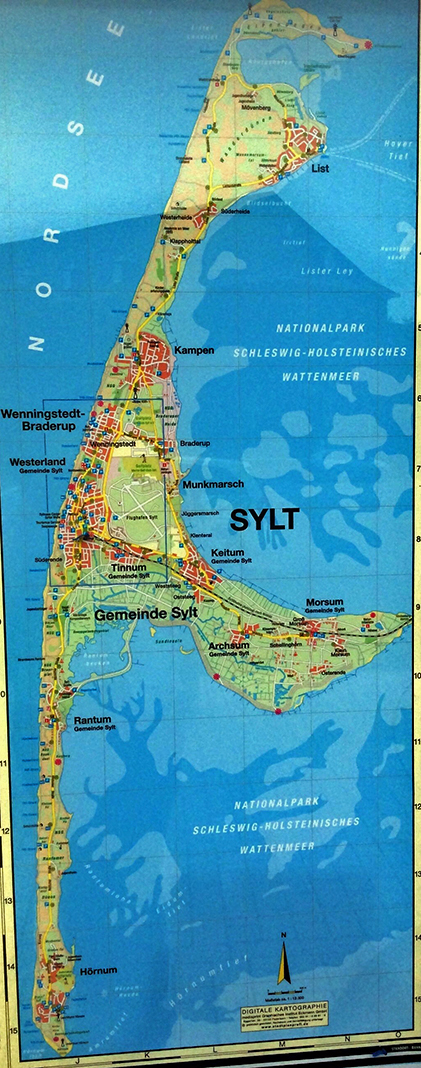


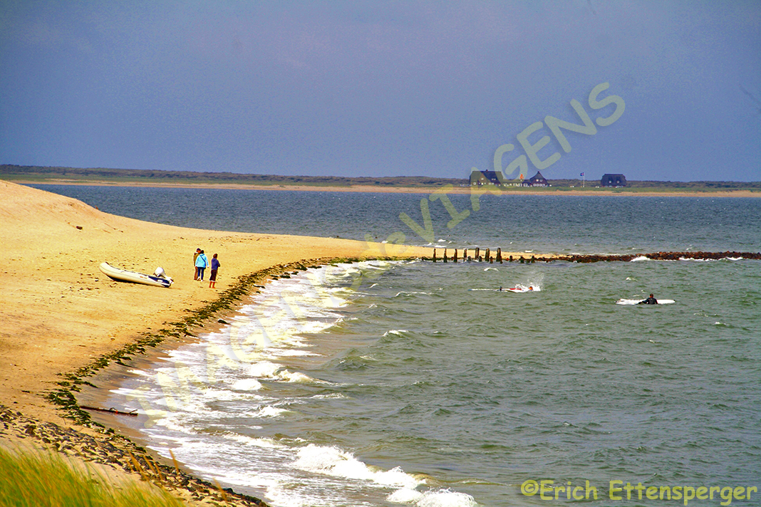


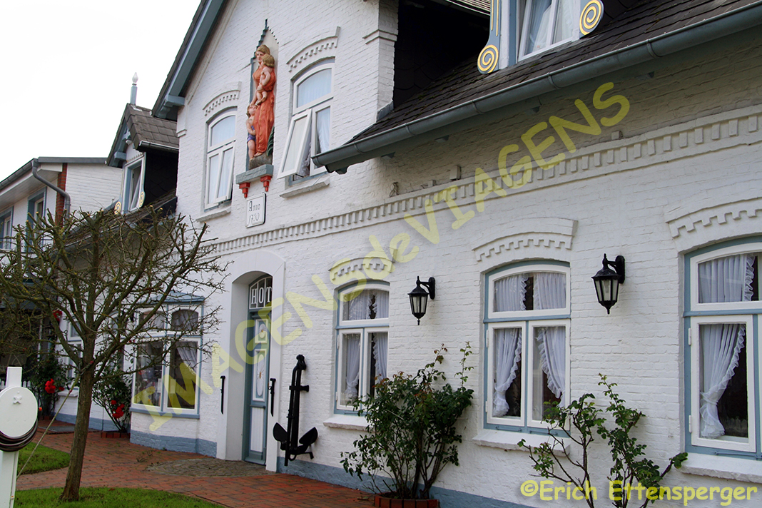


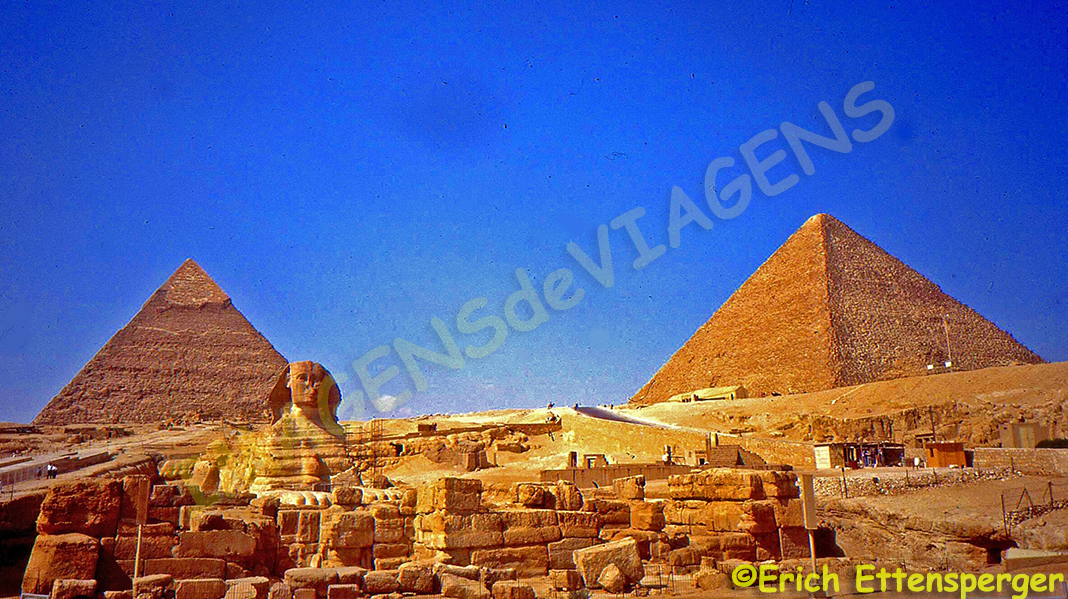


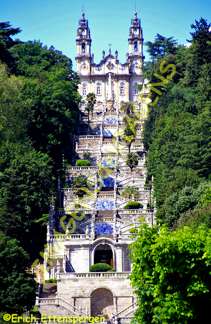
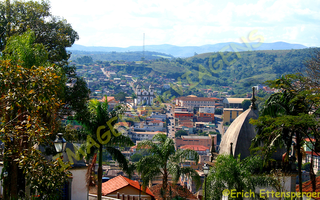


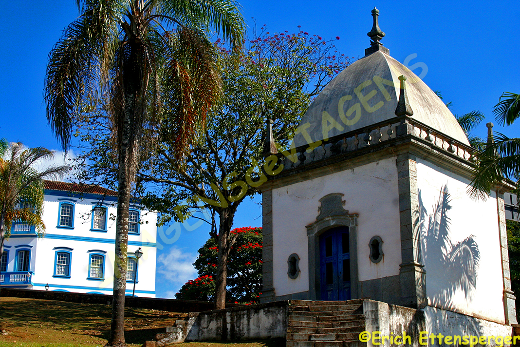


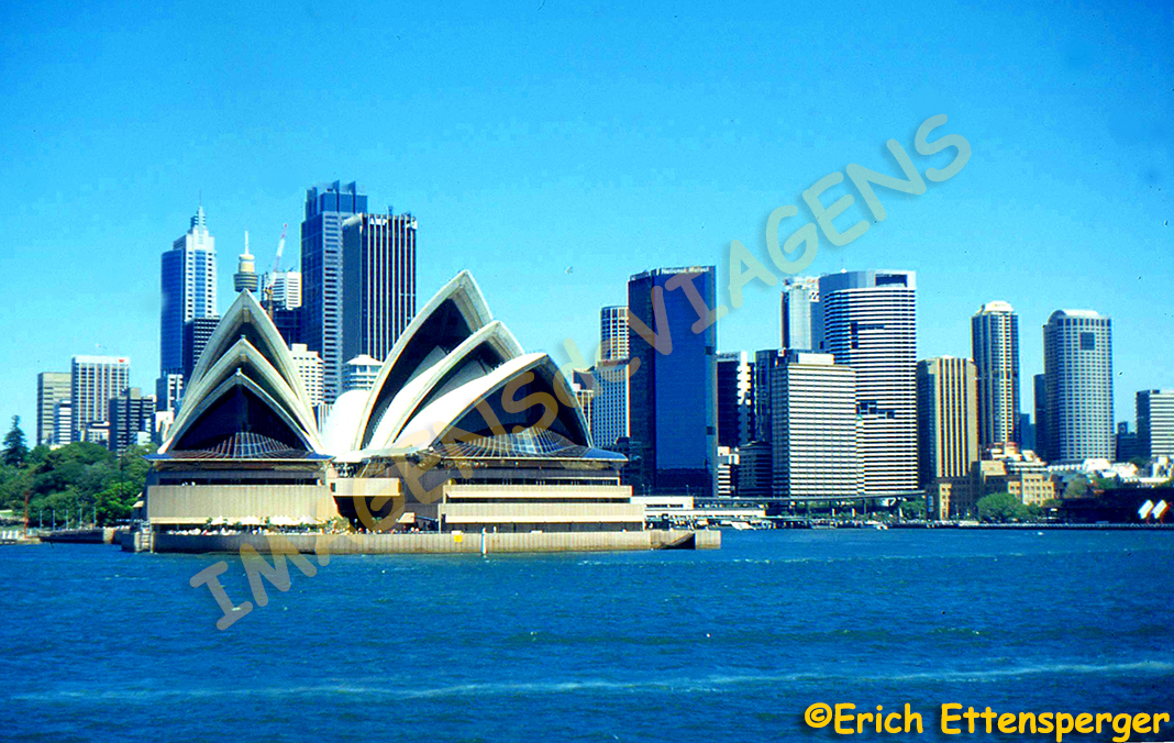


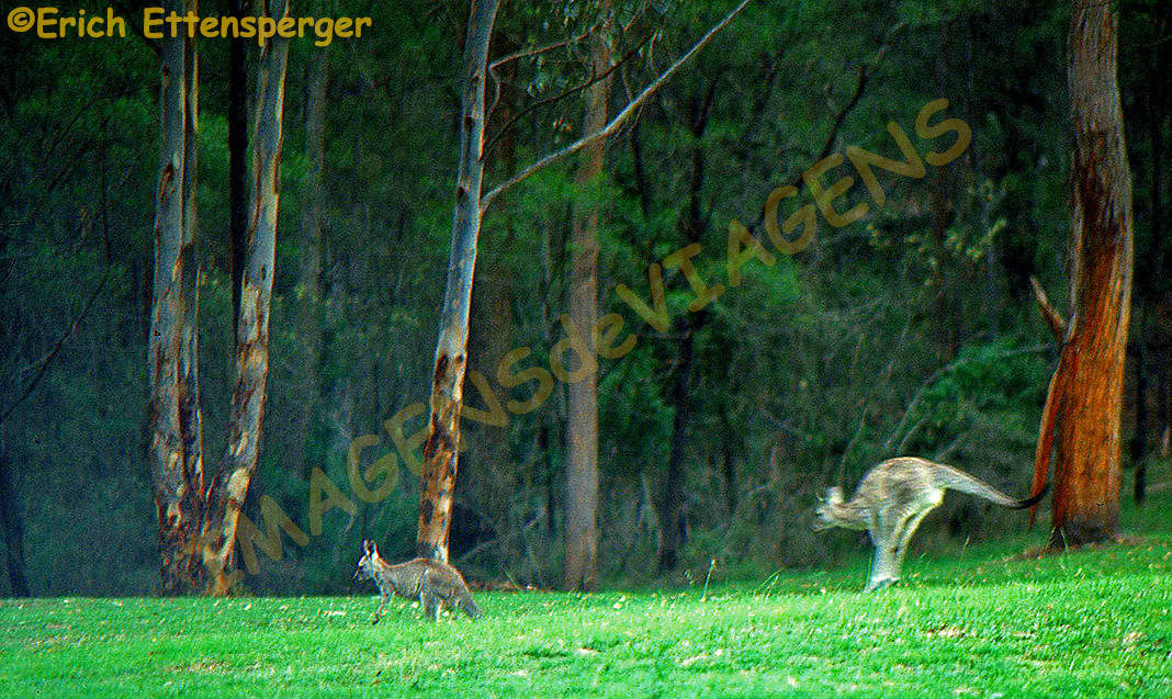


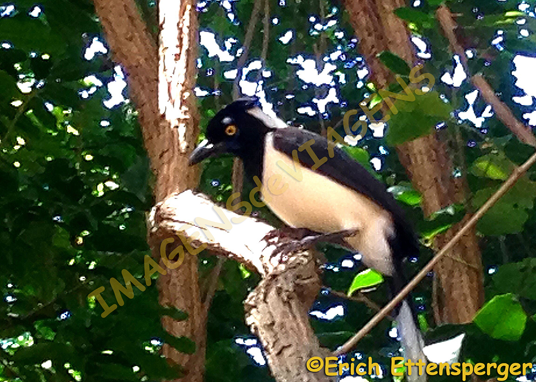


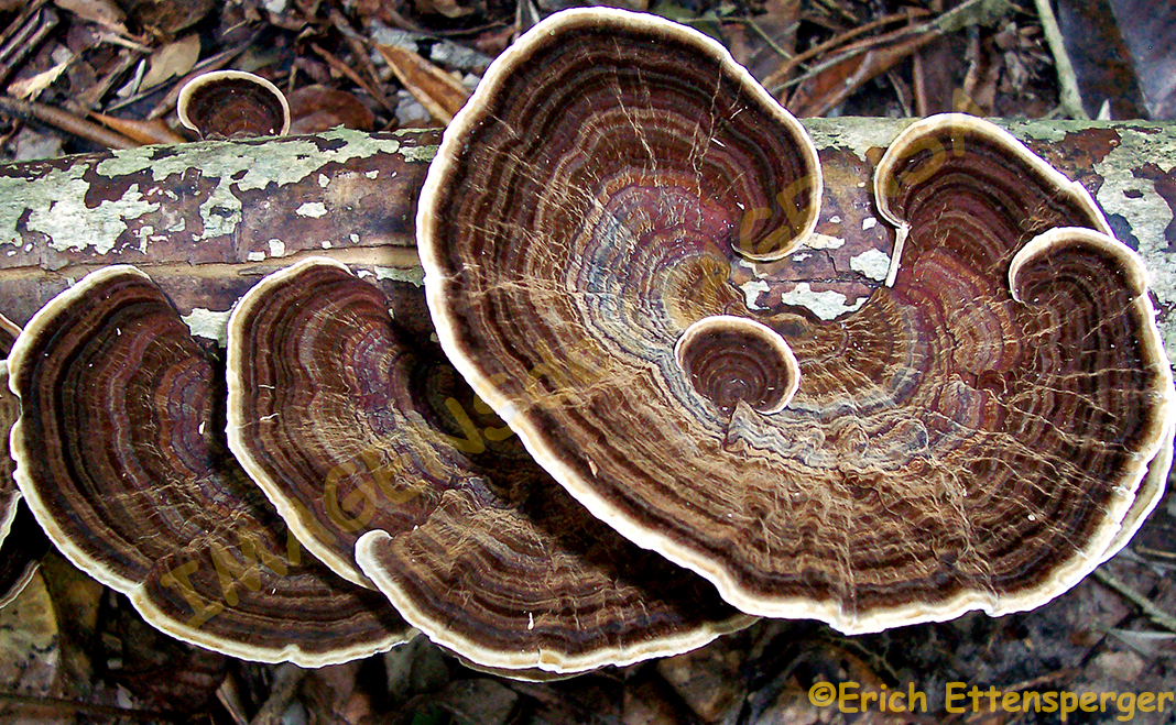


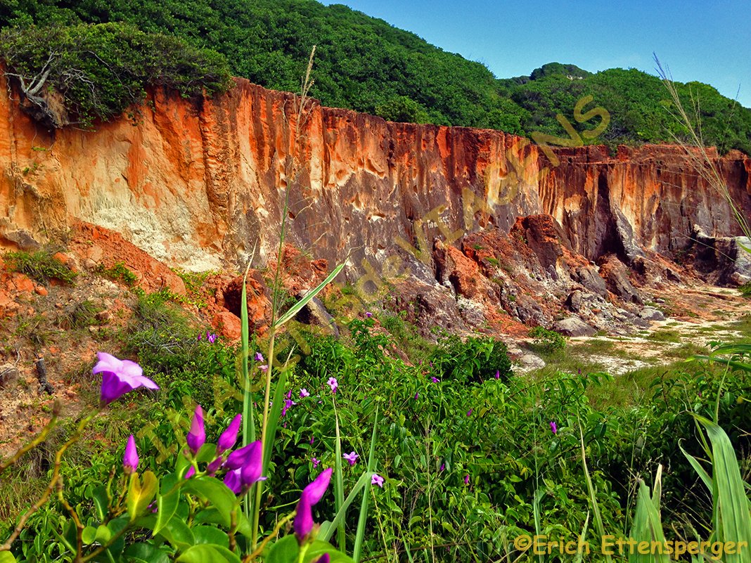


