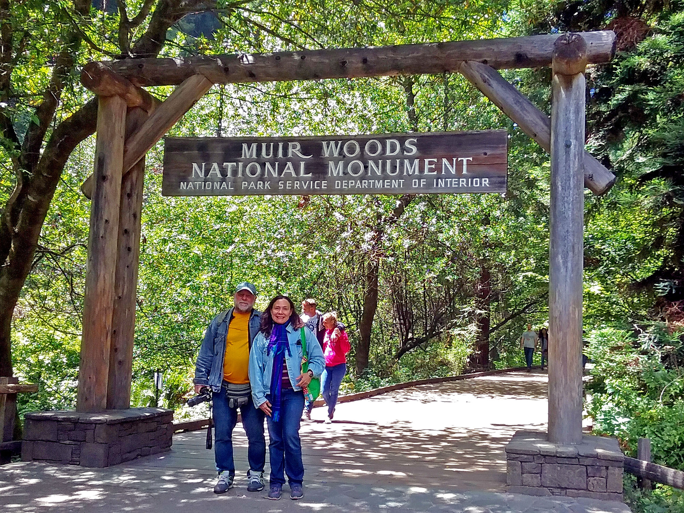
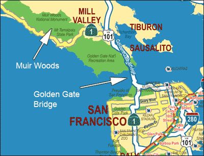
As árvores são seres vivos que se pudessem falar, poderiam contar tanto sobre a história da terra e dos povos. É isso que me lembro quando vejo as árvores antigas como as do Monumento Nacional de Muir Woods, localizadas nas proximidades da cidade de São Francisco, distante 19,31 km da Ponte Golden Gate, na Califórnia.
O Monumento Nacional Muir Woods e a Bacia Hidrográfica do Riacho Redwoods integram a Reserva da Biosfera da Ponte Golden Gate da UNESCO, que engloba 13 áreas protegidas localizadas em torno da baía de São Francisco.
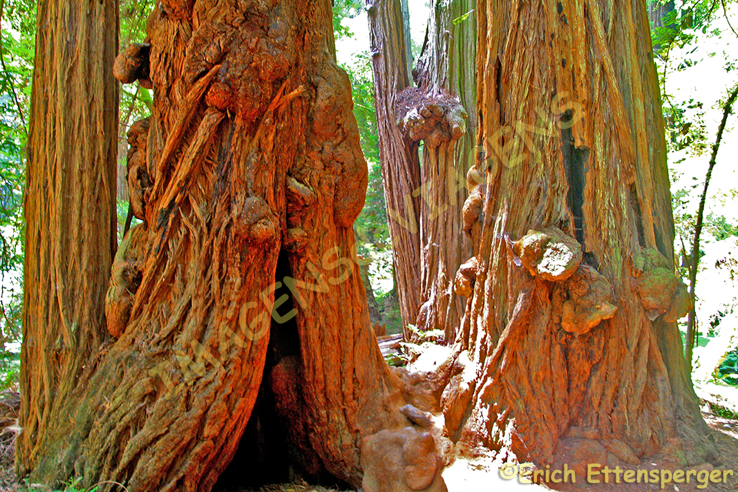
Tive a oportunidade de visitar o Muir Woods,uma das últimas florestas de madeira vermelha (redwood) do planeta.
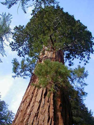
Trata-se das imensas árvores (Sequoia sempervirens), que floresceram na enevoada costa banhada pelas águas do riacho Redwood. As árvores de madeira vermelha cobriram parte do hemisfério norte a 150 milhões de anos atrás. Atualmente existem dois tipos dessas árvores na Califórnia encontradas em áreas limitadas da região:
– “A redwood da costa” – Sequoia semprervirens
– A sequoia gigante – Sequoiadendron giganteum – encontrada no Parque Nacional Yosemite e no Parque Nacional de Sequoia e King Canyon.
Eu sempre quis ver as sequoias, pois já as conhecia através de filmes e livros.
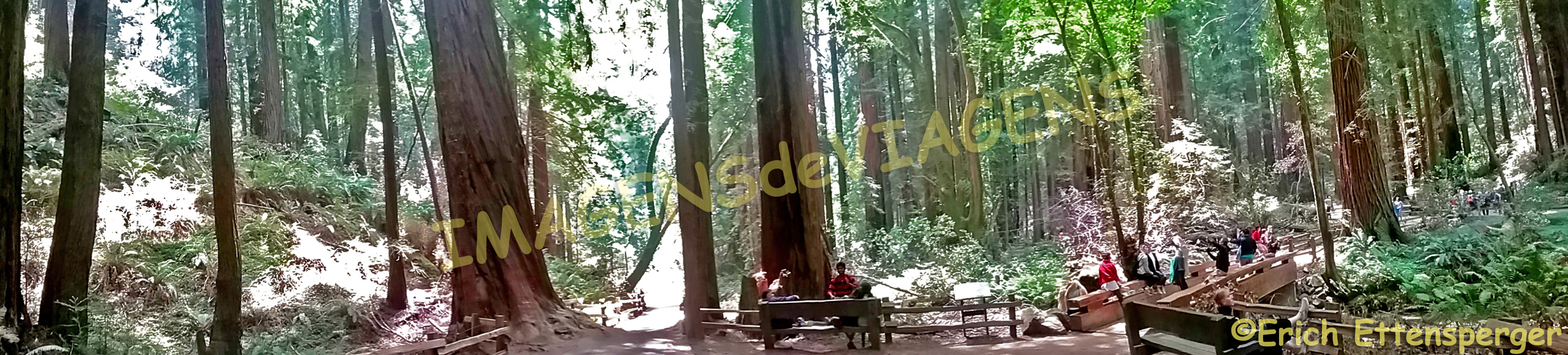
O parque é muito bem organizado e a visita é feita através de trilhas sinalizadas onde a história e a importância desse ecossistema são explicados.
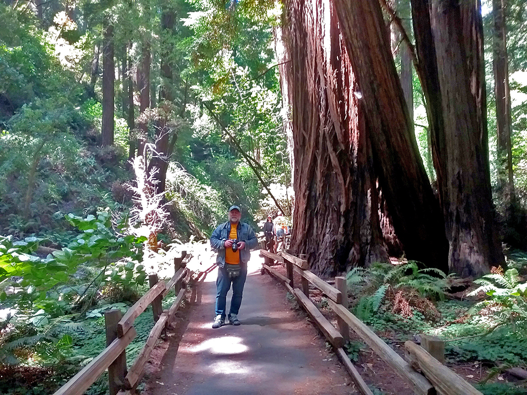
Eu fiquei encantada com a beleza dessas árvores. É possível vê-las agrupadas e algumas solitárias. Também percebi que havia algumas mortas, caídas no chão, que servem de suporte para fungos e outros seres vivos.
Muir Woods é remanescente de um tempo antigo, de um mundo pacífico. Foi o isolamento da área e a dificuldade de acesso que protegeram essas árvores até o começo do século XX. O lugar é para ser visitado com tempo e tranquilidade para que se possa apreciar com profundidade a beleza do parque. Esse não foi o meu caso, passei apenas umas 3 horas lá, mas, mesmo assim, senti aquela felicidade imensa que locais como Muir Woods nos inspira.
Se você se interessa por natureza, aproveite para visitar o Muir Woods quando você visitar São Francisco, vale muito a pena visitar esse monumento natural. Para acessá-lo, você de ir até Sausalito, do outro lado da Ponte Golden Gate e lá, da praça principal, sai o para o parque, somente durante os finais de semana, entre os meses de maio a outubro. O preço do ônibus está incluso no valor do ingresso ao parque. A viagem tem duração, aproximada, de 40 minutos.
Fonte/Quelle/Source: pixelparadox.com From the Pinterest of Emilly Willis
Muir Woods, uma visita que vai ficar para sempre na minha memória.
Para conhecer mais sobre o Monumento Nacional Muir Woods, clique aqui.
Observação: se você quiser continuar “viajando” com o nosso blog, clique no botão “seguir” localizado no canto inferior direito dessa página.
MUIR WOODS IN KALIFORNIEN, ZEUGNIS EINER FERNEN VERGANGENHEIT
Bäume sind Lebewesen, die, wenn sie reden könnten, so viel über die Geschichte des Landes und des Volkes erzählen könnten. Das ist es, an was ich mich erinnere, wenn ich die alten Bäume wie die des Muir Woods National Monumentes in der Nähe von San Franzisko, Kalifornien, nur 19 km von der Golden Gate Bridge entfernt, sehe. Die „Muir Woods“ Wälder und das hydrographische Becken „Redwood Creek“ sind Teil des Biosphärenreservates der Golden Gate Bridge der UNESCO, das 13 Schutzgebiete rund um die Bucht von San Francisco umfasst.
Ich hatte die Gelegenheit die Muir Woods zu besuchen, einer der letzten Rotholzwälder auf unserem Planeten.
Das sind diese riesigen Bäume (Sequoia sempervirens), die an den nebligen Pazifik-Gefilden wachsen durchflossen von den Gewässern des Flusses Redwood Creek. Die Rotholzbäume bedeckten vor 150 Millionen Jahren einen Teil der nördlichen Hemisphäre. Derzeit gibt es zwei Arten dieser Bäume in Kalifornien in relativ begrenzten Bereichen dieser Region:
– “Die Redwood Coast” – Sequoia semprervirens
– Der Riesenmammutbaum – Sequoia dendron giganteum – gefunden im Yosemite Nationalpark und Sequoia Nationalpark und im King Canyon.
Ich wollte schon immer diese Mammutbäume sehen, weil ich sie schon von Filmen und Büchern her kannte.
Der Park ist sehr gut organisiert und der Besuch erfolgt auf markierten Wegen, wo die Geschichte und Bedeutung dieses Ökosystems erklärt werden.
Ich wurde von der Schönheit dieser Bäume völlig bezaubert. Sie können sie in Gruppen zusammen sehen aber auch einige ganz vereinzelt. Auch tote Bäume liegen auf dem Boden und dienen somit Pilzen und anderen Formen von Leben als Daseinsgrundlage.
Muir Woods erinnert an eine alte Zeit, eine friedliche Welt. Es war die Isolation dieses Gebietes und die Schwierigkeit des Zuganges, die diese Bäume bis zum Beginn des 20. Jahrhunderts schützten. Diesen Ort sollte man mit Zeit und Ruhe besichtigen, um die wahre Schönheit des Parks in seiner ganzen Tiefe erspüren zu können. Wir verbrachten nur 3 Stunden dort und trotzdem empfand ich ein groβes Glückgefühl Inspiration von diesem Ort ausgehend.
Falls Sie sich für Natur interessieren, nehmen Sie die Gelegenheit wahr, die Muir Woods zu besuchen, wenn Sie in San Franzisko weilen, es lohnt sich! Sie nehmen von Sausalito auf der anderen Seite der Golden Gate Bridge einen Bus zum Park. Diese verkehren nur an den Wochenenden zwischen Mai und Oktober. Der Preis des Buses ist im Eintrittspreis des Parks enthalten. Die Fahrt dauert ca. 40 Minuten.
Fonte/Quelle/Source: pixelparadox.com From the Pinterest of Emilly Willis
Muir Woods, ein Besuch, der für immer in meinem Gedächtnis bleiben wird.
Um mehr über das Muir Woods National Monument zu erfahren, klicken Sie hier.
Hinweis: Falls Sie unseren “Seguir/Reisen” auf dem Blog folgen wollen, dann klicken Sie unten rechts einfach auf “Weiter”, Sie werden dann zukünftig automatisch informiert.
MUIR WOODS IN CALIFORNIA, TESTIMONY OF A REMOTED PAST
Trees are creatures that, if they could talk, could tell us so much about the history of the country and its people. This is what I remember when I see the old trees like in the Muir Woods National Monument near San Francisco, California, just 19 km from the Golden Gate Bridge. The “Muir Woods” forests and the hydrographic basin “Redwood Creek” are part of the Biosphere Reserve of the Golden Gate Bridge of the UNESCO, which covers 13 protected areas around the Bay of San Francisco.
I had the opportunity to visit Muir Woods, one of the last redwood forests on our planet.
They are these giant trees (Sequoia sempervirens) that grow on the foggy Pacific plains feeded through the waters of the river Redwood Creek. The redwood trees covered a part of the northern hemisphere 150 million years ago. Currently, there are two types of these trees in California in a relatively limited areas of this region:
– “The Redwood Coast” – Sequoia semprervirens
– The Giant Marmot Tree – Sequoia dendron giganteum – found in the Yosemite National Park and Sequoia National Park and the King Canyon.
I’ve always wanted to see these mammoth trees because I’ve known them from films and books.
The park is very well organized and the visit takes place on well marked trails, where also the history and importance of this ecosystem are explained.
I was completely enchanted by the beauty of these trees. You can see them together in groups but also some quite isolated single ones. Even dead trees lie on the ground and thus serve mushrooms and other forms of life as a basis of existence.
Muir Woods recalls an ancient time, a peaceful world. It was the isolation of this area and the difficulty of the access which protected these trees until the beginning of the 20th century. This place should be visited with time and tranquility in order to be able to feel the true beauty of the Park in its entirely depth. We spent only 3 hours there and I still felt a great sense of happiness inspiring from this place.
If you are interested in nature take the opportunity to visit the Muir Woods whilst you are in San Francisco, it’s worth it!
You take a bus from Sausalito on the other side of the Golden Gate Bridge to the Park. These are only available on the weekends between May and October. The price of the bus is included in the entrance-price of the Park. The journey takes about 40 minutes.
Fonte/Quelle/Source: pixelparadox.com From the Pinterest of Emilly Willis
Muir Woods, a visit that will remain in my memory forever.
To find out more about the Muir Woods National Monument, click here.
Note: If you want to follow our “Travels” on the blog, simply click on “/Seguir/Continue” in the lower right corner, you will be then automatically informed in the future.
Las Vegas está localizada no estado de Nevada, numa área desértica. Tem uma população aproximada de 600 mil habitantes. É conhecida como a cidade da diversão dos Estados Unidos.
Las Vegas já foi cenário de muitos filmes, como: Onze Homens e Um Segredo, Se Beber não Case I, Última Viagem a Vegas,Jogo de Amor em Las Vegas, Miss Simpatia 2: Armada e Poderosa,o brasileiro “Até que a sorte nos separe 2”, dentre outros.
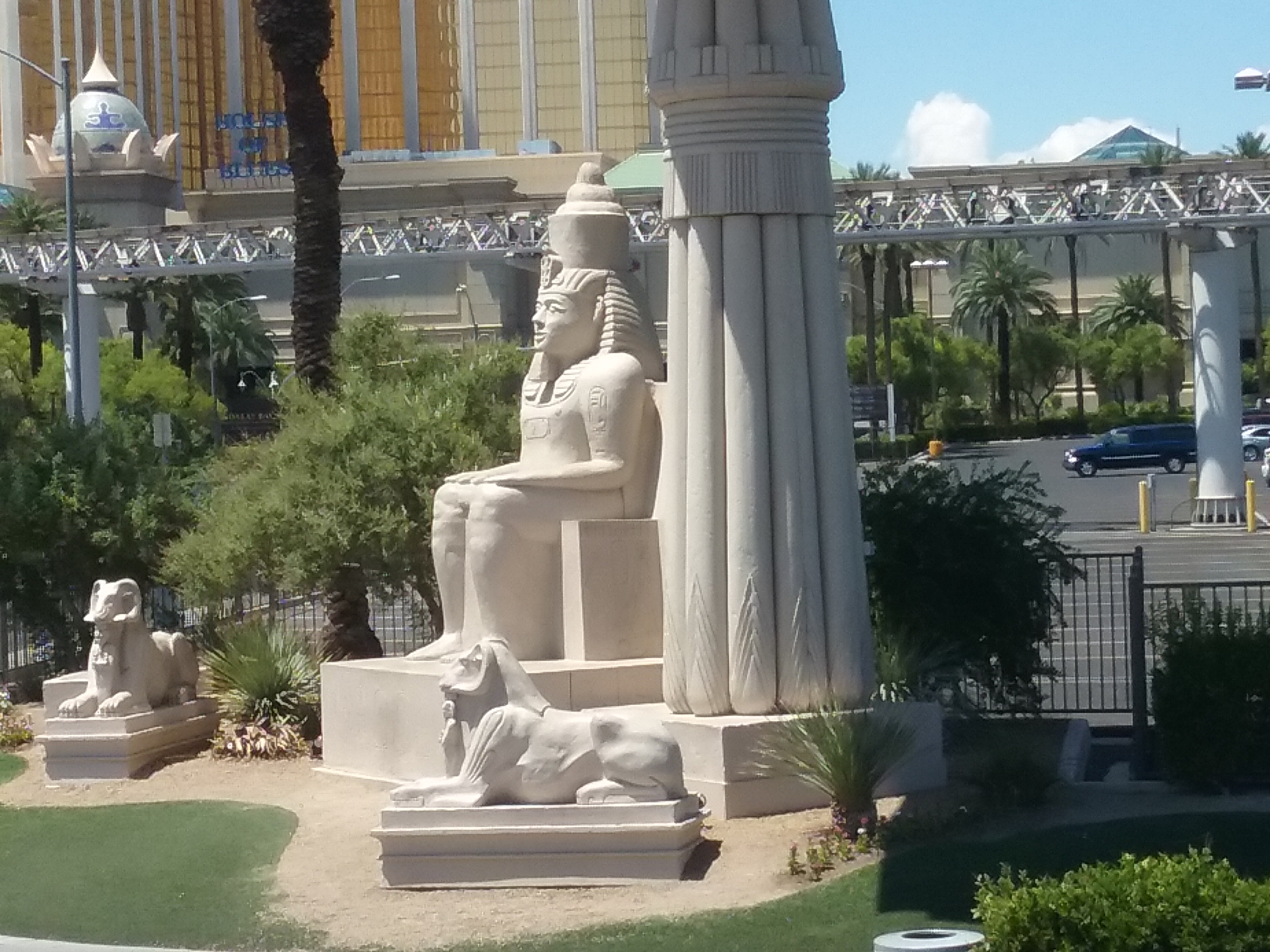
Cheguei em Las Vegas em um dia quente, muito quente de agosto. Dois aspectos me chamaram a atenção de imediato: as máquinas de jogos no aeroporto e uma grande pirâmide que avistei logo quando saí do terminal. Uma pirâmide???? Foi somente o começo…A partir daí, vi a Esfinge de Gizé do Egito,
Esfinge do Hotel Luxor/Die Sphinx des Luxor Hotels/The Sphinx of the Luxor Hotel
uma grande estátua de um faraó egípcio embaixo de uma grande placa de publicidade
e depois de alguns minutos, vi a Torre Eiffel,
A Torre Eiffel, símbolo do Hotel Paris/Der Eiffelturm, Symbol des Hotels Paris/ The Eiffel Tower, symbol of Hotel Paris
os arranha-céus de Nova Iorque, a Estátua da Liberdade,
New York, New York Hotel
o Imperador romano César e as gondolas de Veneza.
Gondolas no Hotel The Venetian/Gondeln des Hotels the Venetian/Gondolas at The Venetian Hotel
Disse a mim mesma: Meu Deus, cheguei em um parque de diversões ou será alucinação? Jamais pensei em ver tudo isso e muito mais, junto! Você sai de Nova Iorque e após uma caminhada, já chegou em Paris! E depois de alguns minutos, já está em Veneza!
Hotel The Venetian/
O grande chamariz da cidade são os hotéis-cassinos.No começo, eles eram mais grandiosos e temáticos, atualmente eles são mais comedidos e modernos. Exemplos de hotéis imensos: MGM Grand (o mais antigo),
Erich na entrada do MGM onde tem uma arena para lutas/Erich am Eingang des MGM, wo es eine Arena für Kämpfe gibt /Erich at the entrance of the MGM where there is an arena for fights
Excalibur, Luxor, Paris, Caesars Palace, The Mirage, The Venetian, The Palazzo. Dentre os mais novos e mais modernos: Ling, Cosmopolitan, dentre outros.
Hotel Excalibur/O famoso Hotel Belaggio onde acontece os show das luzes/Das berühmte Hotel Belaggio mit seiner Lichtershow/The famous Hotel Belaggio where the lights show takes placeMarcia em frente aos jardins do Hotel The Mirage/Marcia em frente aos jardins do Hotel The Mirage/Marcia vor den Gärten des Hotels Mirage/ Marcia in front of the gardens of The Mirage Hotel
Alguns dos grandes hotéis se comunicam entre si, você caminha de um cassino para o outro através de imensos shopping centers. Todas as famosas lojas de grife estão lá. Por exemplo, no hotel Caesar Palace, o shopping center tem um céu azul com nuvens,
nas salas de estar do shopping tem cadeiras em formato da cabeça de César (você literalmente senta na cabeça de César).
Tudo parece, às vezes, tão absurdo, tão fantasioso, tão surreal, que se torna espetacular.
Erich e eu entramos para tomar café da manhã em um desses imensos hotéis e quase não achamos a saída do mesmo. Você circula ouvindo música alta e vendo as máquinas de jogos piscando e emitindo bips, é uma loucura!
Os cassinos tem movimentação permanente/In den Casinos ist immer was los/The casinos have permanent movement
Se quiser conhecer mais sobre Las Vegas, clique aqui.
Observação: se você quiser continuar “viajando” com o nosso blog, clique no botão “seguir” localizado no canto inferior direito dessa página.
EIN UNVORSTELLBARES LAS VEGAS (TEIL I)
Las Vegas befindet sich im Bundesstaat Nevada inmitten einer Wüstenlandschaft. Es hat etwa 600.000 Einwohner. Es ist bekannt als die „Stadt des Amüsements“ in den Vereinigten Staaten.
Las Vegas diente als Kulisse für viele Filme wie zum Beispiel: „Elf Männer und ein Geheimnis“, „Heirate nicht wenn du trinkst I“, „Die letzte Reise nach Vegas“, „Liebesspiel in Las Vegas“, „Fräulein Sympathie 2: bewaffnet und mächtig, der Brasilianer“, „bis uns das Glück trennt 2 “.
Ich bin in Las Vegas an einem heißen, sehr heißen Augusttag angekommen. Zwei Aspekte fielen mir sofort auf: die Spielautomaten am Flughafen und eine große Pyramide, die ich entdeckte, als ich den Terminal verließ. Eine Pyramide???? Aber das war nur der Anfang … Von dort aus sah ich dann die Sphinx von Gizeh inn Ägypten,
Esfinge do Hotel Luxor/Die Sphinx des Luxor Hotels/The Sphinx of the Luxor Hotel
eine große Statue eines ägyptischen Pharaos unter einer riesigen Plakette mit Werbung
und nach ein paar Minuten sah ich dann den Eiffelturm,
A Torre Eiffel, símbolo do Hotel Paris/Der Eiffelturm, Symbol des Hotels Paris/ The Eiffel Tower, symbol of Hotel Paris
die Wolkenkratzer von Neu York, die Freiheitsstatue,
New York, New York Hotel
den römische Kaiser Caesar und die Gondeln von Venedig.
Gondolas no Hotel The Venetian/Gondeln des Hotels the Venetian/Gondolas at The Venetian Hotel
Ich sagte zu mir selbst: Mein Gott, bin ich in einen Vergnügungspark gekommen oder ist das alles nur eine Halluzination? Ich habe nie daran gedacht, das alles und mehr auf einmal zu sehen! Sie verlassen New York und nach einem kurzen Spaziergang sind Sie in Paris angekommen! Und nach ein paar Minuten bist du dann schon in Venedig!
Hotel The Venetian/
Die große Verlockung der Stadt sind die Casinos-Hotels. Am Anfang waren sie grandioser und themenorientiert, derzeit sind sie eher zurückhaltend und modern. Beispiele für diese immensen Hotels: MGM Grand (das älteste),
Erich na entrada do MGM onde tem uma arena para lutas/Erich am Eingang des MGM, wo er eine Arena für Kämpfe /Erich at the entrance of the MGM where he has an arena for fights
Excalibur, Luxor, Paris, Caesars Palace, The Mirage, The Venetian, The Palazzo. Unter den neuesten und modernsten: Ling, Cosmopolitan…usw.
Hotel ExcaliburO famoso Hotel Belaggio onde acontece os show das luzes/Das berühmte Hotel Belaggio mit seiner Lichtershow/The famous Hotel Belaggio where the lights show takes placeMarcia em frente aos jardins do Hotel The Mirage/Marcia em frente aos jardins do Hotel The Mirage/Marcia vor den Gärten des Hotels Mirage/ Marcia in front of the gardens of The Mirage Hotel
Einige der großen Hotels sind miteinander verbunden, man geht von einem Casino zum anderen durch riesige Einkaufszentren. Alle berühmten Designer-Läden sind da. Zum Beispiel im Caesar Palace Hotel verfügt das Einkaufszentrum über einen blauen gewölbten Himmel mit Wolken,
in den Lounges der Mall stehen Stühle in der Form des Kopfes von Caesar (Sie sitzen buchstäblich auf dem Kopf des Julius Cäsar).
Alles erscheint zuweilen so absurd, so phantasievoll, so surreal, sodass es letztendlich spektakulär wirkt.
Erich und ich gingen zum Frühstücken in eines dieser riesigen Hotels und wir haben anschlieβend fast nicht den Ausgang gefunden. Sie spazieren umher umgeben von lauter Musik und blinkenden und piependen Spielmaschinen, …es ist verrückt!
Os cassinos tem movimentação permanente/In den Casinos ist immer was los/The casinos have permanent movement
Hinweis: Falls Sie unseren “Seguir/Reisen” auf dem Blog folgen wollen, dann klicken Sie unten rechts einfach auf “Weiter”, Sie werden dann zukünftig automatisch informiert.
A FABULOUS LAS VEGAS (PART I)
Las Vegas is located in the state of Nevada in the midst of a desert landscape. It has about 600,000 inhabitants. It is known as the „city of amusement“ in the United States.
Las Vegas has served as a backdrop for many films such as “Eleven Men and a Secret,” “Do not Marry when You Drink I,” “The Last Trip to Vegas”, “Love in Las Vegas”, “Miss Sympathy 2: Armed and powerful, the Brazilian “,” Happily seperated 2 “.
I arrived in Las Vegas on a hot, very hot day in August. I noticed two aspects immediately: the game machines at the airport and a large pyramid that I discovered when I left the terminal. A pyramid ???? But that was only the beginning…from there then I saw the Sphinx of Giza in Egypt,
Esfinge do Hotel Luxor/Die Sphinx des Luxor Hotels/The Sphinx of the Luxor Hotel
a large statue of an Egyptian pharaoh under a huge plaque with advertising
and after a few minutes I saw the Eiffel Tower,
A Torre Eiffel, símbolo do Hotel Paris/Der Eiffelturm, Symbol des Hotels Paris/ The Eiffel Tower, symbol of Hotel Paris
the skyscrapers of New York, the statue of liberty,
New York, New York Hotel
the Roman emperor Caesar and the gondolas of Venice.
Gondolas no Hotel The Venetian/Gondeln des Hotels the Venetian/Gondolas at The Venetian Hotel
I said to myself: “My God, have I come to an amusement Park or is it all just a hallucination? I never thought of seeing this all at once! You leave New York and after a short walk you have arrived in Paris! And after another few minutes you’ll be in Venice!
Hotel The Venetian/
The great enticement of the city are the casinos hotels. In the beginning they were more grand and themed, currently they are rather reserved and modern. Examples of these immense hotels are: MGM Grand (the oldest),
Erich na entrada do MGM onde tem uma arena para lutas/Erich am Eingang des MGM, wo er eine Arena für Kämpfe /Erich at the entrance of the MGM where he has an arena for fights
Excalibur, Luxor, Paris, Caesars Palace, The Mirage, The Venetian, The Palazzo. Among the newest and most modern are: Ling, Cosmopolitan … etc.
Hotel ExcaliburO famoso Hotel Belaggio onde acontece os show das luzes/Das berühmte Hotel Belaggio mit seiner Lichtershow/The famous Hotel Belaggio where the lights show takes placeMarcia em frente aos jardins do Hotel The Mirage/Marcia em frente aos jardins do Hotel The Mirage/Marcia vor den Gärten des Hotels Mirage/ Marcia in front of the gardens of The Mirage Hotel
Some of these big hotels are connected, you go from one casino to another through huge shopping centers. All famous designer stores are there. For example at the Caesar Palace Hotel the shopping center has a blue domed sky with clouds,
and the lounges of the mall have chairs in the shape of Caesar’s head (literally sitting on the head of Julius Caesar).
Everything seems so absurd, so imaginative, so surreal, so that ultimately it appears to you spectacular.
Erich and I went to have breakfast in one of these huge hotels and we have almost did not find the exit. You walk around surrounded by loud music and flashing and beeping machines, … is not it crazy?!
Os cassinos tem movimentação permanente/In den Casinos ist immer was los/The casinos have permanent movement
Note: If you want to follow our “Travels” on the blog, simply click on “/Seguir/Continue” in the lower right corner, you will be then automatically informed in the future.
Toronto é uma cidade vibrante, dinâmica, palco de diversos eventos, além de oferecer muitas opções de divertimento. Aliás, o Canadá completa 150 anos em 2017 e por isso, o país, e em especial Toronto, tem uma vasta programação para celebrar a data.
Erich e eu estivemos em Toronto no mês de julho quando as pessoas aproveitam o máximo o céu azul e as altas temperaturas, pois no inverno elas são muitas baixas, podendo chegar a -30 graus centígrados.
Pessoas nas ruas aproveitando o verão/People on the streets enjoying the summer/Menschen den Sommer geniesend
Na tarde em que chegamos a Toronto, depois que deixamos nossa bagagem no hotel, nos dirigimos para a área chamada “Waterfront” localizada nas margens do Lago Ontário com diversos restaurantes, feirinha de artesanato, local onde a pessoa tem acesso aos barcos que fazem passeios no lago.
Por falar em passeio no lago, fiz e gostei muito. Durante o passeio, foi possível observar os arranha-céus da cidade, além de apreciar as muitas ilhas cobertas de vegetação, bela paisagem.
Ilha no Lago Ontário/Island on Lake Ontario/Insel im See Ontario
Esse passeio estava incluído no ticket que compramos para fazer o passeio de ônibus “hop on hop off”. Sempre gostamos de fazer esse tipo de city tour porque podemos ter uma visão geral da cidade e de seus principais atrativos, além de ter uma orientação geral do lugar.
Toronto tem atrativos para todos os gostos: para os que gostam de adrenalina, os que se interessam por cultura, arquitetura, belezas naturais, dentre outras opções. Um programa famoso é visitar a CN Tower e caminhar no topo (Edge Walk), do lado de fora da torre, preso por cabos de aço, literalmente pendurado sobre a cidade. Tive muita vontade de fazer esse programa, mas, infelizmente não tive tempo.
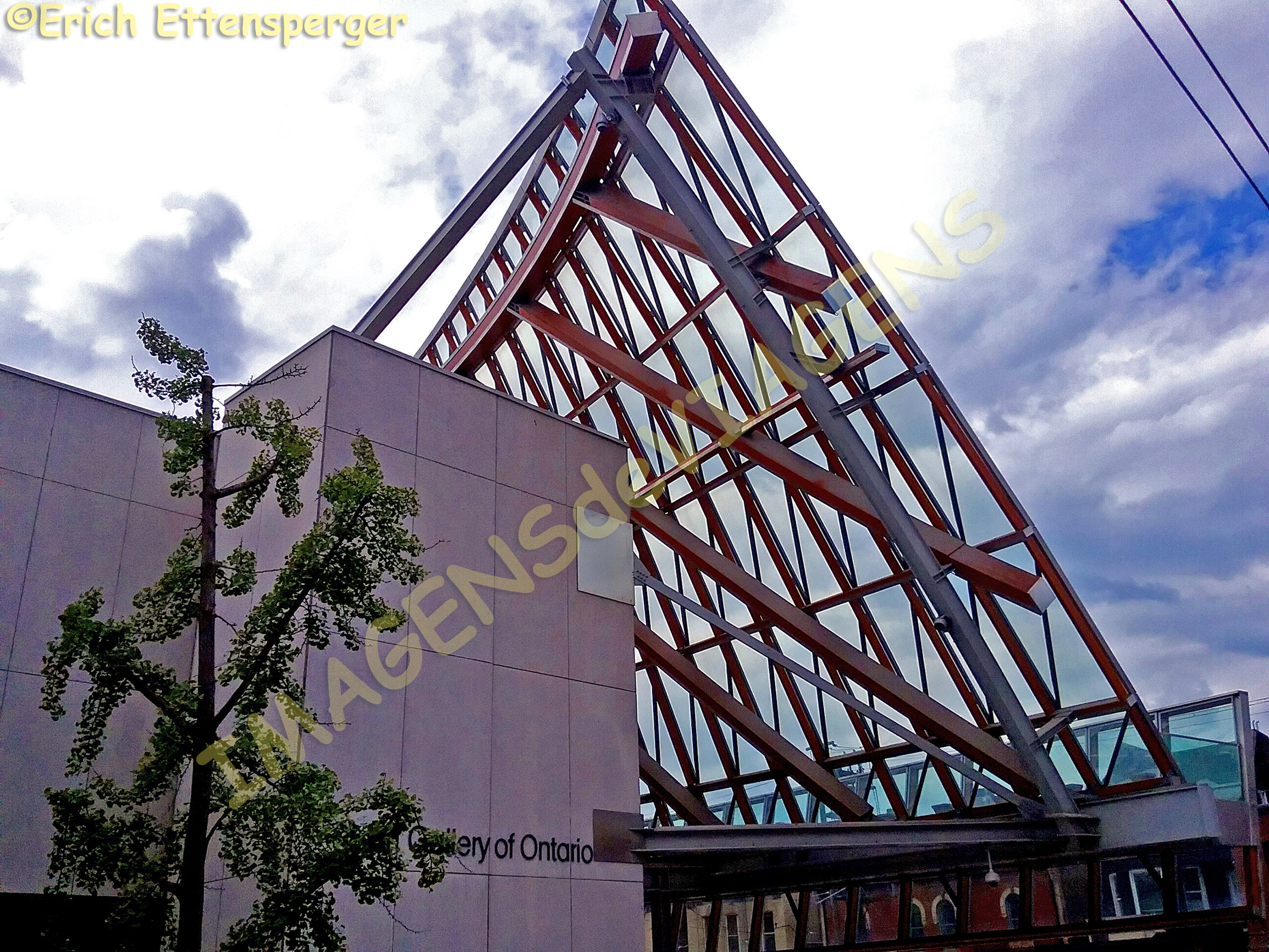
Toronto tem muitos prédios com arquitetura arrojada e criativa, dentre eles, gostei muito do Real Museu de Ontário e da Galeria de Arte de Ontário. A cidade tem outros museus.
Galeria de Arte de Ontário/Art Gallery of Ontario/Kunstgalerie OntarioExemplo de arquitetura vanguardista de Toronto/ Example of avant-garde architecture in Toronto/Beispiel für Avantgarde-Architektur in TorontoReal Museu de Ontário/ Royal Ontario Museum/Royal Museum Toronto
Um lugar interessante, que vale a visita é o Distillery Historic Distrit. Trata-se da maior área preservada de arquitetura industrial vitoriana da América do Norte. A área foi restaurada e revitalizada e hoje funcionam lojas, restaurantes e galerias de arte.
Distrito da Destilaria histórica /Distillery Historic Distrit/Distillery Historic District (ehemaliges Brennerei Viertel)
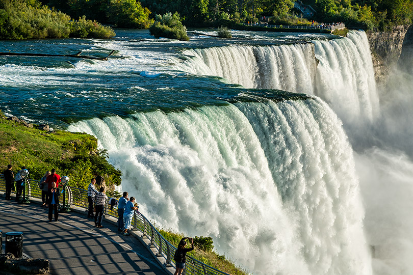
Você pode fazer programas de um dia fora da cidade. O mais famoso é visitar as cataratas chamadas Niagara Falls.
Enfim, Toronto é uma cidade com muitos atrativos, eventos, além de ser multicultural.
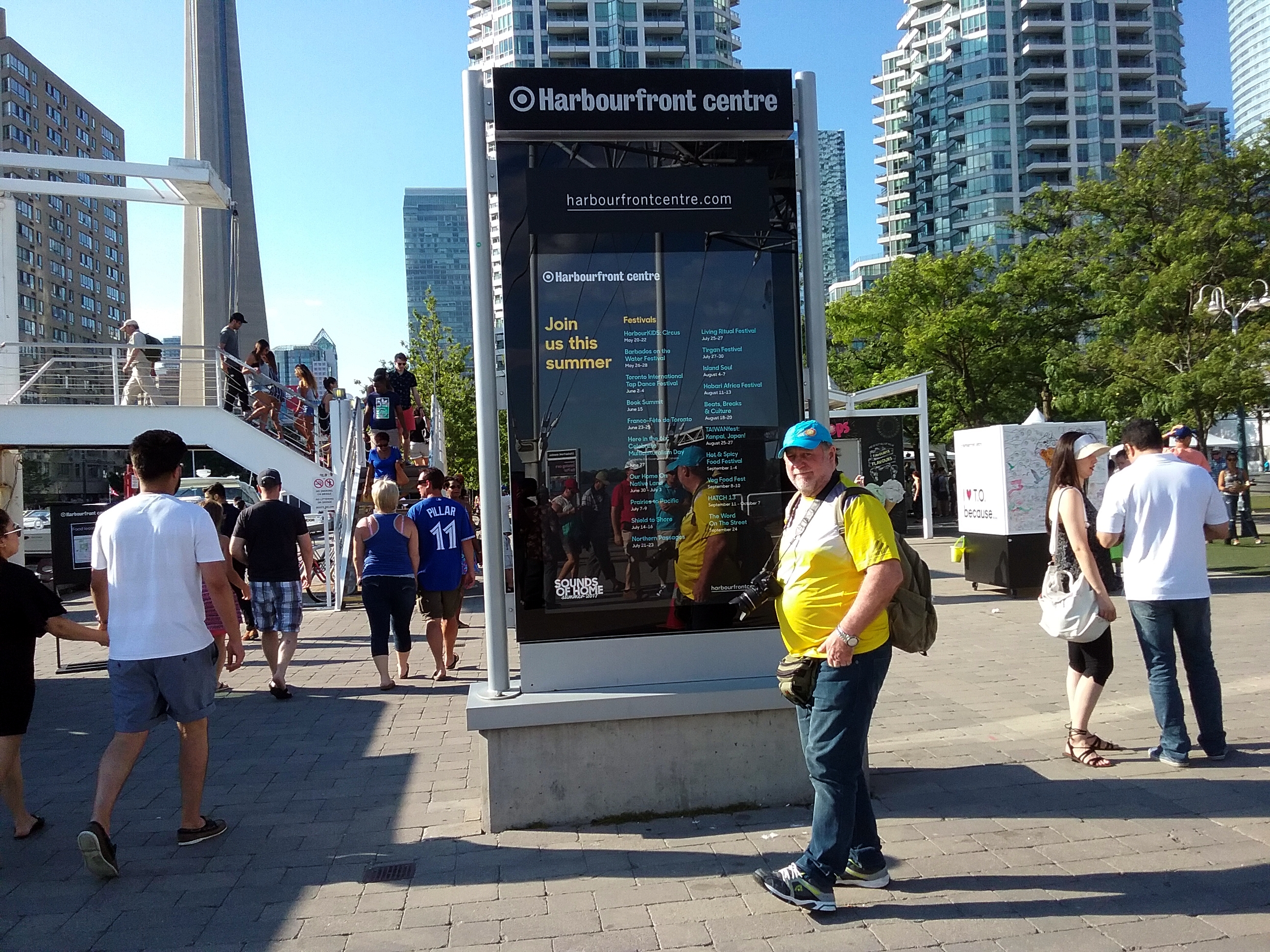
Erich e a programação de eventos do verão/Erich and the summer events schedule/Erich und das Programm der Sommerveranstaltungen
Você encontra bairros chamados Chinatown, Little Portugal, Little Korea. Se você planeja uma viagem ao Canadá, vale a pena incluir Toronto no seu roteiro e pesquise sobre a programação cultural. Se quiser conhecer somente a cidade, recomendo duas noites.
Toronto ao entardecer/Toronto at dusk/Dämmerung in Toronto
p.s.: Há 3 horas de diferença entre Toronto e Vancouver.
Observação: se você quiser continuar “viajando” com o nosso blog, clique no botão “seguir” localizado no canto inferior direito dessa página. Você receberá um email com um link para confirmar a assinatura desse blog (não paga nada). Quando clicar no link, você será direcionado para uma página em inglês (essa página explica o procedimento no caso de você desejar um dia parar de seguir o blog). A partir daí, você já está “seguindo” o blog.
Kulturstadt Toronto
Toronto ist die Hauptstadt der Provinz Ontario und auch zugleich die größte Stadt in Kanada mit fast 3 Millionen Einwohnern.
Toronto ist eine lebendige, dynamische Stadt mit vielen Veranstaltungen und Unterhaltungsmöglichkeiten. In der Tat feiert Kanada 2017 seinen 150. Geburtstag und so versteht es sich, daβ das ganze Land und somit auch Toronto dies entsprechend feiert.
Erich und ich waren im Juli in Toronto, wenn die Leute das Beste aus dem blauen Himmel und den relativ hohen Temperaturen machen, denn im Winter kann es sehr kalt werden mit Temperaturen bis zu -30 Grad Celsius.
Pessoas nas ruas aproveitando o verão/People on the streets enjoying the summer/Menschen den Sommer geniesend
Am Nachmittag nach unserer Ankunft fuhren wir zur Strandpromenade “Waterfront” am Ufer des Sees Ontario mit vielen Restaurants, Märkten und überall sehr vielen Spaziergängern, die wie wir diesen sonnigen Sommertag am Wochenende genossen.
Wir unternahmen einen etwa einstündigen Bootsausflug auf dem See in die der Stadt vorgelagerte kleine Inselwelt mit schöner Landschaft
Ilha no Lago Ontário/Island on Lake Ontario/Insel im See Ontario
und tollem Blick auf die Wolkenkratzer der Stadt. Diese Tour ist Bestandteil des “Hop on Hop off” Bus-Tickets. Wir machen diese Art von Stadtrundfahrt immer deshalb gerne, weil wir somit eine erste Orientierung und einen guten Überblick über die Stadt und ihre Hauptattraktionen bekommen können.
Toronto bietet Attraktionen für jeden Geschmack: für diejenigen, die Adrenalin mögen und für diejenigen, die sich für Kultur, Architektur, Natur und vieles mehr interessieren. Ein berühmtes Programm ist es, den CN-Turm zu besuchen und den „Edge Walk“ auf der Oberseite zu gehen, quasi zu hängen, wahrlich eine Mutprobe in mehr als 350 Metern Höhe. Ich wollte dieses wirklich machen, aber leider hatte ich nicht die Zeit hierfür, da am Wochenende oft ausgebucht.
Toronto verfügt über viele Gebäude mit kühner und kreativer Architektur, unter ihnen genoss ich das Royal Ontario Museum und die Ontario Art Gallery. Die Stadt offeriert viele weitere Museen.
Real Museu de Ontário/ Royal Ontario Museum/Royal Museum TorontoExemplo de arquitetura vanguardista de Toronto/ Example of avant-garde architecture in Toronto/Beispiel für Avantgarde-Architektur in TorontoGaleria de Arte de Ontário/Art Gallery of Ontario/Kunstgalerie Ontario
Ein interessanter Ort, der einen Besuch lohnt, ist der „Distillery Historic District“. Es ist das größte erhaltene Gebiet der viktorianischen Industriearchitektur in Nordamerika. Das Viertel wurde restauriert und revitalisiert und heute findet man viele Geschäfte, Restaurants und Kunstgalerien.
Distrito da Destilaria histórica /Distillery Historic Distrit/Distillery Historic District (ehemaliges Brennerei Viertel)
Jedenfalls ist Toronto eine Stadt mit vielen Attraktionen, Veranstaltungen, einfach multikulturell. Sie finden Nachbarschaften namens Chinatown, Little Portugal, Little Korea. Falls Sie eine Reise nach Kanada planen, lohnt es sich, Toronto und sein Kulturprogramm miteinzubeziehen, falls Sie nur die Stadt kennenlernen möchten, empfehle ich einen Aufenthalt von zwei Nächten1.
Erich e a programação de eventos do verão/Erich and the summer events schedule/Erich und das Programm der Sommerveranstaltungen
Ein Tagesauflug kann Sie zu den berühmten Niagara-Fällen führen.
Weitere Informationen über Toronto, klicken Sie hier.
Toronto ao entardecer/Toronto at dusk/Dämmerung in Toronto
p.s. Der Zeitunterschied zwischen Toronto und Vancouver beträgt 3 Stunden
Hinweis: Falls Sie unseren “Reisen” auf dem Blog folgen wollen, dann klicken Sie unten rechts einfach auf “Weiter”, Sie werden dann zukünftig automatisch informiert.
City of Culture Toronto
Toronto is the capital of the province of Ontario and also the largest city in Canada with nearly 3 million inhabitants.
Toronto is a vibrant, dynamic city with many events and entertainment venues. In fact, Canada is celebrating its 150th birthday in 2017, so it is clear that the whole country, and thus Toronto, is celebrating it accordingly.
Erich and I were in Toronto in July when people do the best of the blue sky and the relatively high temperatures, because in winter it can get very cold with temperatures down to -30 degrees Celsius.
Pessoas nas ruas aproveitando o verão/People on the streets enjoying the summer/Menschen den Sommer geniesend
In the afternoon after our arrival we drove to the beachfront “Waterfront” on the shores of Lake Ontario with lots of restaurants, markets and everywhere a lot of walkers who like us enjoyed this sunny summer day at the weekend.
We undertook an approximately one-hour boat trip on the lake into the small island world with a beautiful landscape and a great view of the skyscrapers of the city.
Ilha no Lago Ontário/Island on Lake Ontario/Insel im See Ontario
This tour is part of the “Hop on Hop off” bus-ticket. We always enjoy this type of city tour because we can get an initial orientation and a good overview of the city and its main attractions.
Toronto offers attractions for all tastes: for those who like adrenaline and those who are interested in culture, architecture, nature and much more. A famous program is to visit the CN tower and to do up there the “Edge Walk” on the top, almost hanging out, really a courage test at more than 350 meters high. I wanted to make this really, but unfortunately I did not have the time to do this, as on weekends very often sold out.
Toronto has many buildings with bold and creative architecture, among which I enjoyed the Royal Ontario Museum and the Ontario Art Gallery. The city offers many other museums.
Real Museu de Ontário/ Royal Ontario Museum/Royal Museum TorontoExemplo de arquitetura vanguardista de Toronto/ Example of avant-garde architecture in Toronto/Beispiel für Avantgarde-Architektur in TorontoGaleria de Arte de Ontário/Art Gallery of Ontario/Kunstgalerie Ontario
An interesting place to visit is the Distillery Historic District. It is the largest preserved area of the Victorian industrial architecture in North America. The neighborhood has been restored and revitalized and today you can find many shops, restaurants and art galleries.
Distrito da Destilaria histórica /Distillery Historic Distrit/Distillery Historic District (ehemaliges Brennerei Viertel)
In any case, Toronto is a city with many attractions, events, it is simply multicultural. You will find neighborhoods called Chinatown, Little Portugal, Little Korea. If you are planning a trip to Canada it is worth to include Toronto and its cultural program, if you only want to get to know the city, I recommend a stay of two nights.
Erich e a programação de eventos do verão/Erich and the summer events schedule/Erich und das Programm der Sommerveranstaltungen
A day’s ride can take you to the famous Niagara Falls.
Toronto ao entardecer/Toronto at dusk/Dämmerung in Toronto
P.S. The time difference between Toronto and Vancouver is 3 hours
Note: If you want to follow our “Travels” on the blog, simply click on “Continue” in the lower right corner, you will be then automatically informed in the future.
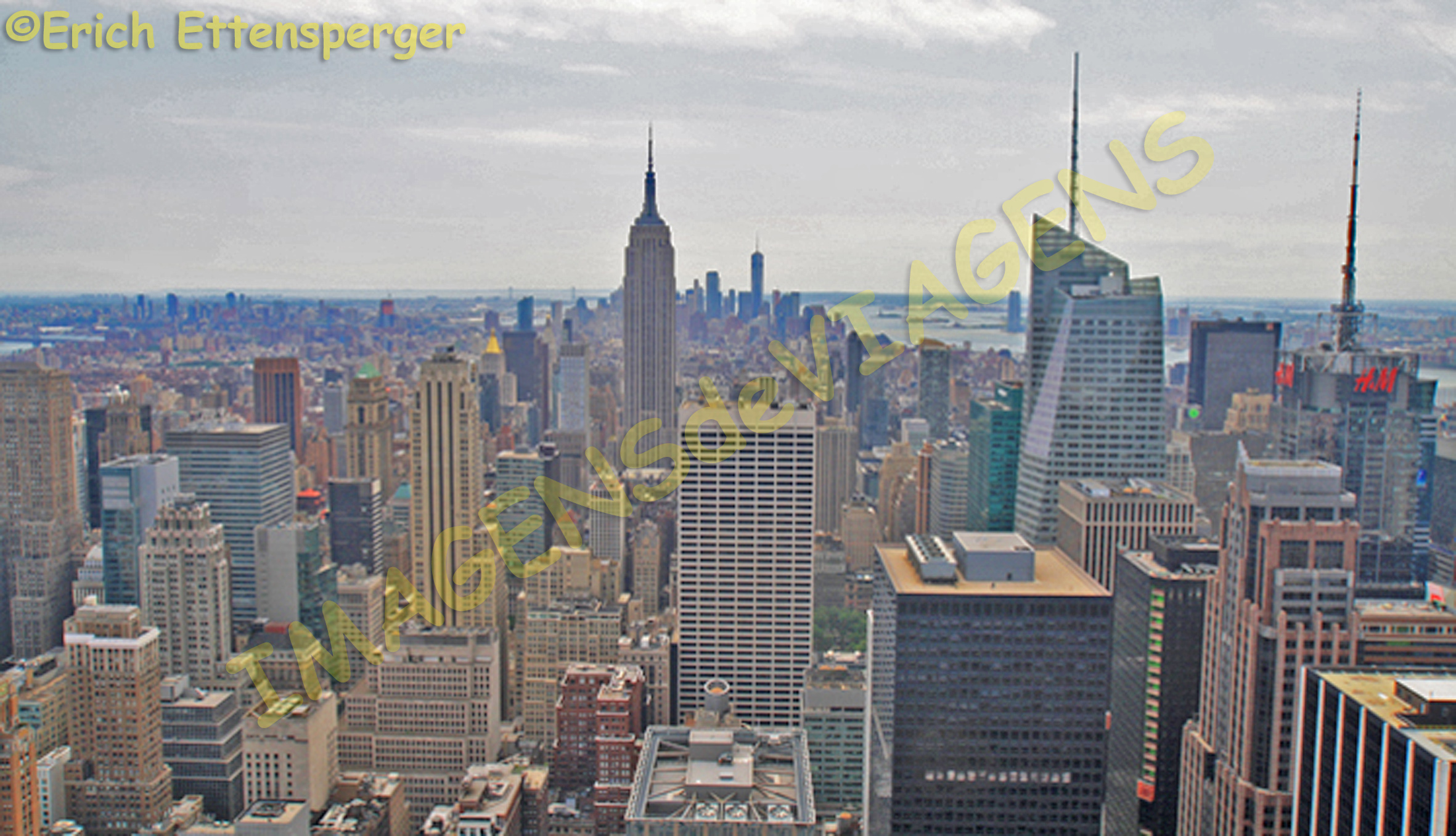
Nova Iorque é uma cidade multicultural, com uma população aproximada de 8 milhões de habitantes, que atrai milhares de visitantes anualmente.
Mapa de localização de Nova Iorque/Lageplan für New York/ Location map of New York
A cidade é constituída por cinco distritos, sendo que 4 estão localizados em ilhas (Staten Island, Brooklyn, Queens e Manhattan) e um no continente, que é o distrito do Bronx. Manhattan concentra a maior quantidade de atrações turísticas.
Os turistas chegam em busca de conhecer os muitos atrativos que a cidade oferece. Uma coisa é clara: você não vai conseguir conhecer tudo. Portanto, pesquise antes de viajar e escolha o que você quer visitar durante sua estadia por lá. Shows na Brodway? Museus? Fazer compras? Ver a cidade do alto?
Nova Iorque vista do alto/New York Blick von oben/New York view from above
São tantas as opções de entretenimento. Se você se interessa por shows, exposições de arte, fique atento, compre os ingressos antes. Considere que sempre há muita gente e filas. Nova Iorque é definitivamente uma cidade cara, mas encantadora.
Manhattan tem 3 grandes áreas: Uptown (ou Upper Manhattan), Downtown (ou Lower Manattan) e Midtown, que é a área central. Erich e eu optamos por nos hospedar no centro, na Midtown e de lá passeamos pela cidade de ônibus (New York Hop-On, Hop-Off Bus), de barco (incluído no ticket do ônibus) e também a pé, foi uma forma que encontramos para fazer nossa atividade física diária e conhecer a cidade. Aliás, caminhar em Nova Iorque é um grande programa para ver as surpresas que a cidade oferece. A cidade é cosmopolita, multicultural, há uma grande diversidade de raças nas ruas de Nova Iorque.
Nova Iorque é uma cidade plana e tem um traçado urbano ortogonal, onde as grandes avenidas e ruas são denominadas por números, como por exemplo, a famosa Quinta Avenida. É fácil se orientar nas ruas de Nova Iorque. Aliás, é na Quinta Avenida onde estão localizadas as grandes e famosas lojas, como a Apple, Louis Vuitton, dentre outras. O pulmão verde da cidade é o Central Park, circundado por edifícios, cujo metro quadrado e muito valorizado.
Central Park
Existem programas clássicos para quem visita a cidade pela primeira vez: Broodway, Times Square (Dica: visite a Times Square ao entardecer quando está bem movimentada, então é só curtir),
Estátua da Liberdade,
A famosa estátua da Liberdade localizada no porto de Nova Iorque/Die berühmte Freiheitsstatue befindet sich im Hafen von New York/the famous Statue of Liberty located in the port of New York
Empire State Building, (existe outro edifício, mais alto que o Empire e é muito visitado, trata-se do Rockfeller Center onde está localizado o Top on the Rock), Ground Zero, Ponte do Brooklin,
Ponte do Brooklin/Brooklyn-Brücke/Brooklyn Bridge
de onde você tem uma vista arrebatadora da Ilha de Manhattan.
Dentre os locais que eu visitei, o que mais me emocionou foi o Ground Zero, local das Torres Gêmeas, onde está localizado o memorial às vítimas do atentado de 11 de setembro.
Ground Zero
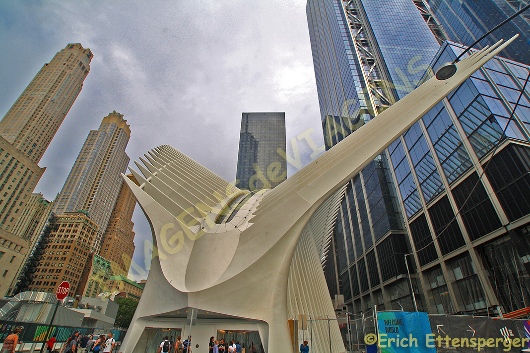
Nessa área, há também a nova estação de metrô, chamada World Trade Center (PATH),
Estação de metro World Trade Center/World Trade Center U-Bahnstation/World Trade Center Tube Station
com um salão oval chamado Oculus.O projeto da estação é do arquiteto espanhol Santiago Calatrava. O local é espetacular, o edifício é todo branco e quando você entra, tem uma exposição chamada “UP CLOSE Michelangelos Sistine Chapel” no centro. Definitivamente recomendo visitar essa área.
Exposição UP Capela Sistina/Ausstellung UP Sixtinische Kapelle /Exhibition UP Sistine Chapel
Outro passeio interessante, é passear na High Line Park, uma sugestão para quem gosta de caminhar e apreciar a natureza.
High Line Park
Um programa bem legal em Nova Iorque é curtir um bar no topo de algum edifício, como o bar Le Bain, onde você pode ver o entardecer e as luzes da cidade se acenderem. Dica: o Le Bain fica próximo ao High Line.(Atenção: alguns desses cafés e bares podem estar reservados para eventos privados durante o fim de semana).
Nova Iorque é definitivamente uma cidade para ser visitada várias vezes, cada vez você vai descobrir algo novo, aproveitar para ver algo que você não viu da última vez. Eu, com certeza, já tenho minha listinha para a próxima viagem.
Observação: se você quiser continuar “viajando” com o nosso blog, clique no botão “seguir” localizado no canto inferior direito dessa página. Você receberá um email com um link para confirmar a assinatura desse blog (não paga nada). Quando clicar no link, você será direcionado para uma página em inglês (essa página explica o procedimento no caso de você desejar um dia parar de seguir o blog). A partir daí, você já está “seguindo” o blog.
New York, dynamisch und sprudelnd
New York ist eine multikulturelle Stadt mit einer Bevölkerung von etwa 8 Millionen, die Tausende von Besuchern alljährlich anzieht.
Mapa de localização de Nova Iorque/Lageplan für New York/ Location map of New York
Die Stadt besteht aus fünf Bezirken, von denen vier auf Inseln (Staten Island, Brooklyn, Queens und Manhattan) und einer auf dem Festland, die Bronx, befindet. Manhattan ist die Heimat vieler Touristenattraktionen.
Die Touristen kommen der vielen Attraktionen wegen, die die Stadt bietet. Eines ist klar: Sie werden nie alles sehen. Also recherchieren Sie, was Sie während Ihres Aufenthalts dort besuchen möchten. Brodway? Museen Einkaufen? Die Stadt von oben?
Nova Iorque vista do alto/New York Blick von oben/New York view from above
Es gibt so viele Unterhaltungsmöglichkeiten. Wenn Sie an Shows, Kunstausstellungen interessiert sind, kaufen Sie die Tickets bevor. Denken Sie daran, überall sind immer viele Leute und Warteschlangen. New York ist definitiv eine teure, aber charmante Stadt.
Manhattan teilt sich auf in 3 große Bereiche: Uptown (oder Upper Manhattan, Downtown (oder Lower Manattan) und Midtown.
Erich und ich entschieden uns, in Midtown in der Innenstadt unser Hotel zu nehmen und von dort aus mit dem Hop-On/Hop-Off Bus, mit dem Schiff (im Busticket enthalten) und v.a. zu Fuß (unser tägliches Fitnessprogramm) New York zu erkunden. Die Stadt ist kosmopolitisch, multikulturell und in den Straßen sind eine Vielfalt an Nationalitäten unterwegs.
New York ist eine flache Stadt und hat eine orthogonale städtische Gestaltung, wo die großen Boulevards und Straßen nummeriert sind, wie z.B. die berühmte Fifth Avenue, wo sich all die großen Marken und berühmten Läden wie Apple, Louis Vuitton usw. befinden. Die Orientierung in der Stadt fällt einem leicht.
Die grüne Lunge der Stadt ist der Central Park, umgeben von Gebäuden mit exorbitant hohen Quadratmeterpreisen.
Central Park
Es gibt die klassischen Programme für alle, die die Stadt zum ersten Mal besuchen: Broadway, Times Square,
Freiheitsstatue,
A famosa estátua da Liberdade localizada no porto de Nova Iorque/Die berühmte Freiheitsstatue befindet sich im Hafen von New York/the famous Statue of Liberty located in the port of New York
das Empire State Building oder einen der anderen berühmten Wolkenkratzer, das Ground Zero und die Brooklyn Bridge
Ponte do Brooklin/Brooklyn-Brücke/Brooklyn Bridge
mit dann herrlichem Blick auf Manhattan.
Unter den Orten, die ich besuchte, bewegte mich am meisten der Ground Zero, die Gedenkstätte für die Opfer der Attentate vom 11. September.
Ground Zero
In diesem Bereich befindet sich auch die neue U-Bahnstation “World Trade Center” (PATH) mit einer Ovalhalle namens Oculus.
Estação de metro World Trade Center/World Trade Center U-Bahnstation/World Trade Center Tube Station
Das Projekt der Station ist vom spanischen Architekt Santiago Calatrava. Der Ort ist einfach spektakulär, das Gebäude ist ganz weiß und wenn man es betritt, offeriert es eine Ausstellung namens “UP CLOSE Michelangelos Sistine Chapel” im Zentrum. Ein Besuch dieser U-Bahnstation ist absolut empfehlenswert.
Exposição UP Capela Sistina/Ausstellung UP Sixtinische Kapelle /Exhibition UP Sistine Chapel
Eine weitere sehr interessante Tour ist es, auf der High Line zu schlendern, ein Vorschlag für all diejenigen, die gerne spazieren gehen und ein „biβchen“ Natur genießen wollen.
High Line Park
Ein weiteres „cooles“ Programm in New York ist es, eine der vielen Bars auf einem der vielen hohen Gebäude zu genießen, wie z.B. die Bar Le Bain, wo man den Sonnenuntergang beobachten kann und die Lichter der Stadt. (Achtung: manche dieser Cafes und Bars können am Wochenende nur für private Events zugänglich sein)
Tip: bei Dämmerung und Dunkelheit ist auf und rund um den Times Square immer viel los, einfach eintauchen.
New York ist definitiv eine Stadt, die ganz einfach mehrmals besucht werden kann und jedes Mal können ganz neue Dinge entdeckt werden.
Ich jedenfalls habe sicherlich schon meine Liste für die nächste Reise nach NEW YORK.
Hinweis: Falls Sie unseren “Reisen” auf dem Blog folgen wollen, dann klicken Sie unten rechts einfach auf “Weiter”, Sie werden dann zukünftig automatisch informiert.
New York – dynamic and bubbly
New York is a multicultural city with a population of about 8 millions which attracts thousands of visitors annually.
Mapa de localização de Nova Iorque/Lageplan für New York/ Location map of New York
Tourists come to visit the many attractions that the city offers. One thing is clear: you will never see all. So research what you want to visit during your stay there. The Brodway, museums, shopping? The city from above?
Nova Iorque vista do alto/New York Blick von oben/New York view from above
There are so many entertainment possibilities. If you are interested in shows, art exhibitions buy the tickets before. Remember, everywhere are always lots of people and queues.
New York is definitely an expensive but charming city.
Manhattan is divided into 3 major areas: Uptown (or Upper Manhattan, Downtown (or Lower Manattan) and Midtown.
Erich and I decided to take our hotel in Midtown in the city center and exploring from there the City by using the hop-on / hop-off buses, the boat (included in the bus ticket) and a lot by walking, our daily fitness program. The city is cosmopolitan, multicultural and you see a variety of many different nationalities in the streets.
New York is a flat city and has an orthogonal urban design where the large boulevards and streets are numbered like for example the famous Fifth Avenue, where all the great brands and famous shops such as Apple, Louis Vuitton, etc. are located. The orientation in the city is therefore very easy.
The green lung of the city is the Central Park surrounded by buildings with exorbitantly high square meter prices.
Central Park
There are the classic programs for those who visit the city for the first time: Broadway, Times Square,
Statue of Liberty,
A famosa estátua da Liberdade localizada no porto de Nova Iorque/Die berühmte Freiheitsstatue befindet sich im Hafen von New York/the famous Statue of Liberty located in the port of New York
the Empire State Building or one of the other famous skyscrapers, Ground Zero and the Brooklyn Bridge
Ponte do Brooklin/Brooklyn-Brücke/Brooklyn Bridge
and then a magnificent view of Manhattan.
Very much touching to me was the Ground Zero, the memorial for the victims of the assassinations of September 11.
Ground Zero
In this area is also located the new subway station “World Trade Center” (PATH) with an oval hall called Oculus.
Estação de metro World Trade Center/World Trade Center U-Bahnstation/World Trade Center Tube Station
The project of the station was done by the Spanish architect Santiago Calatrava. The place is simply spectacular, the building is white and when you enter it it offers an exhibition called “UP CLOSE Michelangelo Sistine Chapel” in the center. A visit to this subway station is absolutely recommendable.
Exposição UP Capela Sistina/Ausstellung UP Sixtinische Kapelle /Exhibition UP Sistine Chapel
Another very interesting tour is to stroll along the High Line, a suggestion for all those who like to walk and even enjoy a “bit of nature”.
High Line Park
Another ‘cool’ program in New York is to enjoy one of the many bars on one of the many high buildings like for example the bar Le Bain where you can watch the sunset and the lights of the city. (Attention: some of these cafes and bars might be open for private events only during the weekend)
Tip: Stay at dusk and darkness on and around the Times Square, it is always busy, just dive into this atmosphere.
New York is definitely a city that can easily be visited several times and every time new things can be discovered.
I certainly have already made my list for the next trip to NEW YORK.
Note: If you want to follow our “Travels” on the blog, simply click on “Continue” in the lower right corner, you will be then automatically informed in the future.
Glaciar Hubbard no Alasca, dramático e inesquecível
O Alasca é o maior estado pertencente aos Estados Unidos e está localizado no noroeste da América do Norte e tem parte de seu território cortado pelo Círculo Polar Ártico.
Mapa de localização do Glaciar Hubbard na América do Norte/Karte mit Gletscher Hubbard in Nordamerika/Map with Glacier Hubbard in North America
Para você ter uma ideia do tamanho do Alasca, sua área corresponde a 4 estados da California e 12 Nova Iorques!!!!!A capital do Alasca é Anchorage.
Quando eu pensava no Alasca, logo imaginava um lugar cheio de neve e muito frio. Por isso, pensei que nunca ia ter coragem de visitar tal destino. Muitos amigos também imaginam o Alaska assim. Porém, o Alaska também tem verão e é a época do ano mais visitada por turistas, que procuram esse destino para estar próximo à natureza e conhecer as belezas do lugar viajando de navio, são os “turistas de cruzeiro”, pois uma das melhores formas de conhecer as belezas naturais do Alaska é através de uma viagem de cruzeiro.
O acesso para muitos lugares é feito somente por navio e avião. Há também pessoas que viajam até o Alasca para verem o fenômeno da Aurora Boreal, que ocorre no período entre o final de agosto e abril . No nosso caso, Erich e eu decidimos por fazer uma viagem de cruzeiro pelo Alasca que durou sete dias, sendo que nessa semana, dois dias foram “cruzeiro cênico”, quando o navio não para em nenhum porto e você navega por lugares fascinantes.Foi no primeiro dia do cruzeiro cênico, que conheci o Glaciar Hubbard.
Mapa de localização do Glaciar Hubbard no Alasca/Karte mit Gletscher Hubbard in Alaska/Map with Glacier Hubbard in Alaska
Erich e eu fomos para o deque sete do navio (a embarcação tinha 16 deques) e esperamos para chegar no Hubbard Glacier. A medida que fomos nos aproximando, observei que o mar, nesse caso, o Oceano Pacífico estava pontilhado por pedaços de gelo, pequenos icebergs, que se despreenderam do glaciar e ficaram boiando na superfície da água. Alguns eram totalmente brancos, outros eram mesclados com partes marrom, vestígios das rochas que foram arrancadas no processo de formação do glaciar.
Fomos nos aproximando do Glacier Hubbard lentamente. A visão do mesmo é dramática e estonteante. Ele resplandece numa tonalidade mesclada entre o branco, o azul e partes escurecidas. A visão é espetacular. Além da visão do mesmo, é possível escutar o estrondo de partes que se despreendem e caem no mar.
Glaciar Hubbard/Hubbard Glacier/Hubbard-Gletscher
A imagem do Glaciar Hubbard no Alasca é um das visões mais impressionantes que a mãe natureza nos oferece. É uma verdadeira maravilha!
Glaciar Hubbard/Hubbard Glacier/Hubbard-Gletscher
Glaciar Hubbard é uma das visões mais memoráveis e incríveis que vi na minha vida.
Observação: se você quiser continuar “viajando” com o nosso blog, clique no botão “seguir” localizado no canto inferior direito dessa página. Você receberá um email com um link para confirmar a assinatura desse blog (não paga nada). Quando clicar no link, você será direcionado para uma página em inglês (essa página explica o procedimento no caso de você desejar um dia parar de seguir o blog). A partir daí, você já está “seguindo” o blog.
Der Hubbard Gletscher in Alaska, dramatisch und unvergesslich
Alaska mit seiner Hauptstadt Anchorage ist der größte Bundesstaat in den Vereinigten Staaten und befindet sich im Nordwesten Nordamerikas und ein Teil seines Territoriums liegt jenseits des Polarkreises.
Mapa de localização do Glaciar Hubbard na América do Norte/Karte mit Gletscher Hubbard in Nordamerika/Map with Glacier Hubbard in North America
Um eine Vorstellung von der Größe von Alaska zu geben, es entspricht 4 mal der Gröβe Kaliforniens und 12 mal der des Staates New York !!!!!
Als ich an Alaska dachte, stellte ich mir immer einen Ort vor voller Schnee und sehr kalt. Also dachte ich, daβ ich nie den Mut aufbrächte, ein solches Ziel zu besuchen. Viele meiner Freunde stellen sich Alaska auch genauso vor.
Allerdings hat Alaska auch einen Sommer und das ist genau die Zeit des Jahres, in der die meisten Touristen kommen. Hierbei ist u.a. eine Kreuzfahrt eine der besten Möglichkeiten, diese unvergleichliche Natur zu erleben und zu genieβen.
Der Zugang zu vielen Orten erfolgt nur per Schiff und Flugzeug. Es gibt auch Leute, die nach Alaska reisen, um das Phänomen der Aurora Borealis zu sehen, welches zwischen Ende August und April auftritt.
In unserem Fall entschlossen sich Erich und ich, eine siebentägige Alaska-Kreuzfahrt zu machen, davon waren zwei Tage eine sogenannte “szenische Kreuzfahrt”, wenn das Schiff in keinem Hafen anlegt und nur durch faszinierende Szenarien navigiert.
Mapa de localização do Glaciar Hubbard no Alasca/Karte mit Gletscher Hubbard in Alaska/Map with Glacier Hubbard in Alaska
Es war am ersten Tag der malerischen Kreuzfahrt als wir uns dem Hubbard-Gletscher näherten und wir uns das Ganze zunächst vom Deck 7 der insgesamt 16 Etagen des Schiffes bestaunten.
Je näher wir kamen, umso mehr schwimmende Eisstücke und kleine Eisberge trieben an der Wasseroberfläche um unser Schiff. Das Meer schien plötzlich punktiert zu sein von schwebenden ganz weißen Eisstücken, kleinen Eisbergen, die vom Gletscher mit Getöse abfielen und anderen braunen Teilen, Spuren von Felsen, die durch die Gletscherbildung abgerissen wurden.
Wir näherten uns langsam dem Hubbard Gletscher. Der visuelle Anblick ist dramatisch und blendend. Es erscheint alles in einem Farbton, der zwischen weißen, blauen und verdunkelten Teilen verschmolzen ist. Die Aussicht ist spektakulär. Neben dem Anblick dessen hörst du immer wieder vom Absturz von Glletscherteilen, die unter Getöse abfallen und ins Meer stürzen.
Glaciar Hubbard/Hubbard Glacier/Hubbard-Gletscher
Das Bild des Hubbard Gletschers in Alaska ist eine der beeindruckendsten Sehenswürdigkeiten, die Mutter Natur uns bietet. Es ist ein wahres Wunder!
Glaciar Hubbard/Hubbard Glacier/Hubbard-Gletscher
Der Hubbard Gletscher ist einer der denkwürdigsten und unglaublichsten Sehenswürdigkeiten, die ich jemals in meinem Leben gesehen habe.
Hinweis: Falls Sie unseren “Reisen” auf dem Blog folgen wollen, dann klicken Sie unten rechts einfach auf “Weiter”, Sie werden dann zukünftig automatisch informiert.
The Hubbard Glacier in Alaska, dramatic and memorable
Alaska with its capital Anchorage is the largest state in the United States and is located in the north-west of North America and part of its territory is beyond the Polarkreises.
Mapa de localização do Glaciar Hubbard na América do Norte/Karte mit Gletscher Hubbard in Nordamerika/Map with Glacier Hubbard in North America
To give an idea of the size of Alaska, it is 4 times the size of California and 12 times the state of New York !!!!!
When I thought of Alaska, I always imagined a place full of snow and very cold. So I thought that I never would have the courage to visit such a destination. Many of my friends felt as well the same regarding Alaska.
However, Alaska also has a summer and that is exactly the time of the year in which most tourists come. Hereby a cruise is one of the best ways to experience and enjoy this incomparable nature.
The access to many places is given by ship and plane only. There are also people who travel to Alaska to see the phenomenon of the Aurora Borealis occurring between the end of August and April.
In our case, Erich and I decided to make a seven-day Alaska cruise, two days of it were a so-called “scenic cruise” when the ship was not docking in any port and only navigating through fascinating scenarios.
Mapa de localização do Glaciar Hubbard no Alasca/Karte mit Gletscher Hubbard in Alaska/Map with Glacier Hubbard in Alaska
It was on the first day of the picturesque cruise as we approached the Hubbard glacier and we gazed first at the whole from the deck 7 of the ship with its 16 floors.
The nearer we came, the more floating ice pieces and small icebergs drifted along the water surface around our ship. The sea suddenly seemed to be punctuated by floating whole white ice-pieces, small icebergs falling from the glacier with dripping, and other brown parts, traces of rocks torn by the glacier.
We slowly approached the Hubbard Glacier. The visual aspect is dramatic and dazzling. It all appears in a hue fused between white, blue, and darkened parts. The view is spectacular.
In addition to the sight, you always hear of the crash of glacier parts, which fall under loud dull noise and plunge into the sea.
Glaciar Hubbard/Hubbard Glacier/Hubbard-Gletscher
The image of the Hubbard Glacier in Alaska is one of the most impressive sights Mother Nature offers us. It is a true miracle!
Glaciar Hubbard/Hubbard Glacier/Hubbard-Gletscher
The Hubbard Glacier is one of the most memorable and unbelievable sights I’ve ever seen in my life.
Note: If you want to follow our “Travels” on the blog, simply click on “Continue” in the lower right corner, you will be then automatically informed in the future.
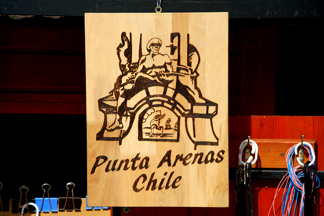
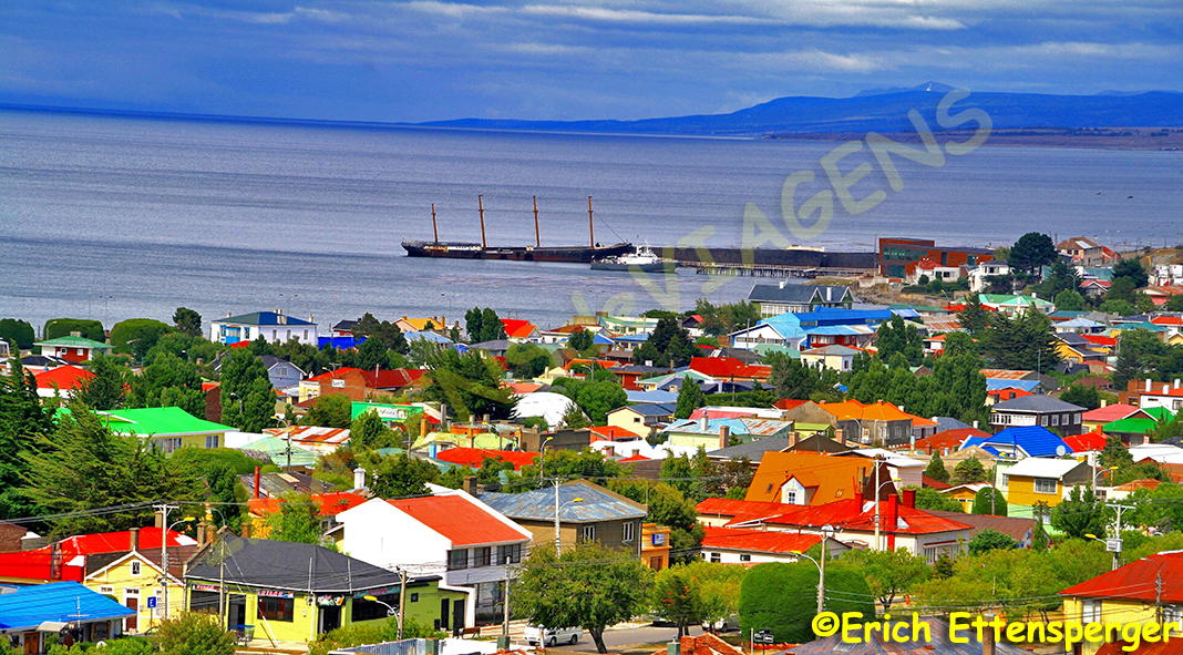
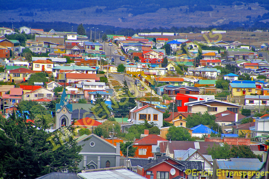
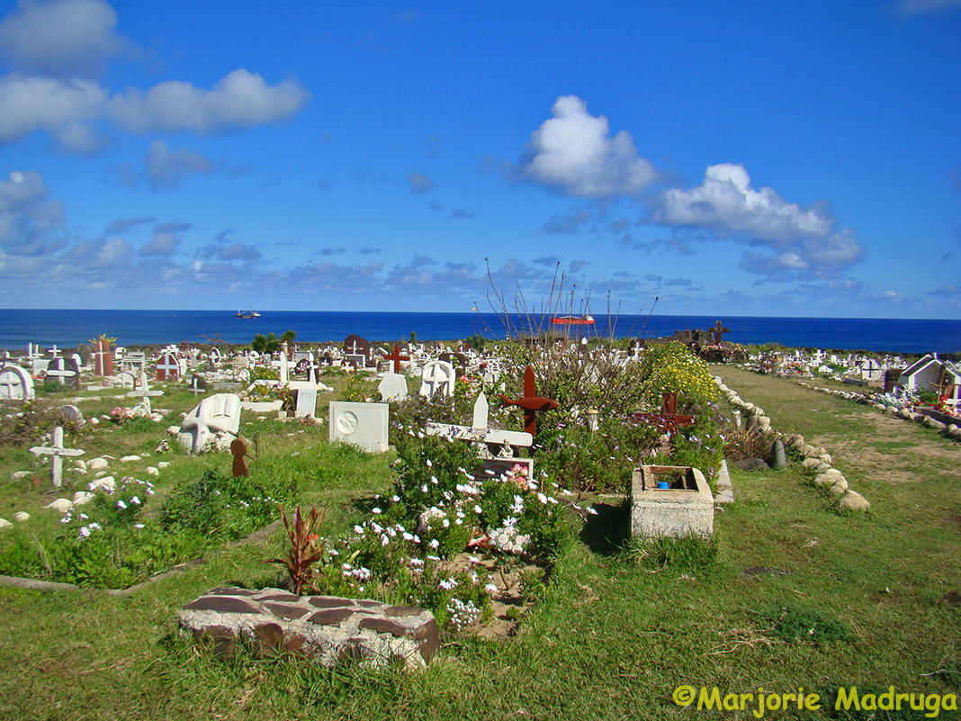
Punta Arenas está localizada no Chile e é a capital da província de Magalhães e encontra-se nas proximidades do Estreito de Magalhães. Quando não existia o Canal do Panamá, era passagem obrigatória para os navios que atravessavam o Cabo Horn.
Punta Arenas continua a ser uma cidade próspera até hoje, graças aos seus ricos recursos naturais. A cidade é também o portão de entrada para a Patagônia Chilena, um labirinto de fiordes, rios, estepes e montanhas ao norte. Ao sul encontra-se a grande massa congelada da Antártica. O fim do mundo.
Através do Estreito de Magalhães, passagem entre os oceanos Atlântico e Pacífico, descoberta por Fernão de Magalhães em 1520, se alcança a Terra do Fogo, a solitária Terra do Fogo. A região foi povoada por imigrantes iogoslavos e ingleses que se estabeleceram no local durante o século XIX, quando desenvolveram a criação de ovelhas.
A Colina da Cruz oferece uma vista fantástica da cidade e do Estreito de Magalhães.
Durante nossa visita a Punta Arenas, gostamos muito da feirinha e do clima encontrado na Plaza Muñoz Gamero, local central da cidade.
Sombreada pela copa dos pinheiros, a praça é envolto por mansões de estilo barroco do século XIX,
No centro da praça tem um monumento em homenagem a Fernando de Magalhães.
Você pode visitar também o Museu Salesiano Margiorino Borgatello, que é um testemunho da vida dos habitantes indígenas e do ecossistema no extremo sul.
OInstituto recebe-o numa visita ao Museu de Memórias ao ar livre. Você vai testemunhar uma coleção de antiguidades agrícolas e máquinas industriais importadas da Europa, uma típica casa pioneira e galpão (reconstruído), e um reboque de madeira de rodas que serviu de abrigo para os pastores.
Uma visita rápida ao Cemitério Pioneiro, com seu grande pórtico de pedra gigante, apresenta um pouco sobre a história de Punta Arenas.
Vivemos um dia agradável em Punta Arenas, caminhando pelas suas ruas,tomando um café e apreciando suas casas coloridas,
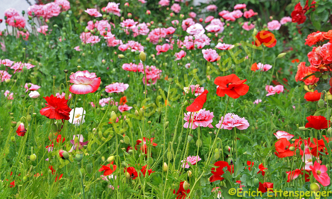
vendo flores coloridas nos jardins residenciais,
durante o curto verão,quase no fim do mundo, no Estreito de Magalhães.
Nosso plano original era o de visitor o Parque Nacional Torres del Paine, uma das mais espetaculares região do mundo, uma das maiores da América do Sul. Mas, devido ao mau tempo, nosso voo foi cancelado e assim,não pudemos visitar esse magnifico parque, ficou para outra vez…
Se quiser conhecer mais sobre Punta Arenas clique aqui.
Observação: se você quiser continuar “viajando” com o nosso blog, clique no botão “seguir” localizado no canto inferior direito dessa página. Você receberá um email com um link para confirmar a assinatura desse blog (não paga nada). Quando clicar no link, você será direcionado para uma página em inglês (essa página explica o procedimento no caso de você desejar um dia parar de seguir o blog). A partir daí, você já está “seguindo” o blog.
Punta Arenas – Hauptstadt der Magallanes Region
Es liegt auf den Hügeln mit Blick auf die Straße von Magellan. In den Tagen vor dem Panamakanal war dies ein wichtiger Hafen, als die Schiffe die Gewässer von Kap Horn meideten.
Punta Arenas bleibt bis heute eine wohlhabende Stadt dank seiner reichen natürlichen Ressourcen. Die Stadt ist auch das Tor zum Patagonien Chiles, einem Labyrinth aus Fjorden, Flüssen, Steppen und Bergen im Norden. Im Süden liegt die große gefrorene Masse der Antarktis. Das Ende der Welt.
Oberhalb der Magellan -Straße liegt Feuerland, diese einsame, windgepeitschte Insel, die von Magellan im Jahre 1520 entdeckt wurde. Die Region wurde im 19. Jahrhundert von jugoslawischen und englischen Schafviehzüchtern besiedelt.
Die La Cruz Hügel bietet einen fantastischen Blick auf Punta Arenas und die Straße von Magellan.
Wir genossen den kleinen Markt, das Leben und die Atmosphäre auf dem Plaza Muñoz Gamero, dem zentralen Platz von Punta Arenas.
Schattiert von einem Baldachin von Pinien, ist der Platz von barockartigen Herrenhäusern aus dem 19. Jahrhundert umgeben
und hier findet sich auch das Hernando de Magallanes Denkmal, das Ferdinand Magellan gewidmet ist.
Sie können auch das Salesianische Museum Marggiorino Borgatello besuchen, das ein Zeugnis für das Leben der indigenen Einwohner und das Ökosystem im fernen Süden ist.
Das Patagonien-Institut lädt ein zur Besichtigung des Freiluftmuseums. Sie werden Zeuge einer Sammlung von antiken Bauern- und Industriemaschinen, die aus Europa importiert wurden, sie sehen ein typisches Pionierhaus und einen Scherenschuppen (rekonstruiert) und einen hölzerner Anhänger, der den Hirten als Schutz diente.
Ein kurzer Besuch auf dem Pionierfriedhof mit seinem steinernen Eingangstor und den europäischen Zypressen gibt Zeugnis von der Geschichte Punta Arenas.
Während dieses Tages in Punta Arenas haben wir lange Spaziergänge gemacht, die bunten Häuser und ihre Dächer gesehen
und die schönen Blumen in vielen Gärten
während dieser so kurzen Periode der Sommerzeit hier fast am Ende der Welt an der Magellan-Straße bewundert.
Ursprünglich wollten wir von hier weiter zum Nationalpark Torres del Paine reisen. Es ist eine der spektakulärsten Landschaften der Welt; es ist sicherlich eine der Hauptattraktionen in ganz Südamerika. Aber wegen der schlechten Wettervorhersage wurde unser Flug abgesagt, was für uns letztendlich nur das eine bedeutete –Aufgeschoben ist nicht Aufgehoben !!!!
Hinweis: Falls Sie unseren “Reisen” auf dem Blog folgen wollen, dann klicken Sie unten rechts einfach auf “Weiter”, Sie werden dann zukünftig automatisch informiert.
Punta Arenas – Capital of the Magallanes region
It lies atop rolling hills, looking out over the Strait of Magellan. In the days before the Panama Canal, this was a major port as ships plied the waters of Cape Horn.
Punta Arenas remains a prosperous town today, thanks to its rich natural resources. The city is also the gateway to Chilean Patagonia, a maze of fjords, rivers, steppes, and mountains to the north. To the south lies the great frozen mass of Antarctica. The end oft he world.http://www.worldatlas.com/aatlas/infopage/magellan.htm
Across the Strait of Magellan lies Tierra del Fuego, the lonely, windswept island discovered by Magellan in 1520. The region was settled by Yugoslavian and English sheep ranchers in the 19th century.
The La Cruz Hill offer fantastic views of Punta Arenas and the Strait of Magellan.
We liked the small Market, the life and atmosphere of the Plaza Muñoz Gamero, Punta Arenas’ central plaza.
Shaded by a canopy of pine trees, the plaza is enveloped by baroque-style mansions from the 19th century,
and boasts the Hernando de Magallanes Monument dedicated to Ferdinand Magellan.
You can visit also Salesian Museum Marggiorino Borgatello, which is a testimony to the life of the indigenous inhabitants and the ecosystem in the far south.
The Patagonia Institute welcomes you on a tour of the outdoor Museum of Memories. You’ll witness a collection of antique farm and industrial machinery imported from Europe, a typical pioneer house and shearing shed (reconstructed), and a wooden-wheeled trailer that served as shelter for shepherds.
A short visito f the Pioneer Cemetery gives a reflection of the history of Punta Arenas fronted by a giant stone portico and landscaped with sculpted European cypress trees.
During this day in Punta Arenas we enjoyed walking a lot and we liked to see the colorful houses
and the beautiful flowers in the gardens
during this so short period of summertime here almost at the end oft he world here at Strait of Magellan.
Originally we wanted to continue to travel to the Torres del Paine National Park. It is one of the most spectacular scenic regions in the world; it is certainly one of the major attractions in South America. But due to bad weather forecast our flight was cancelled what means finally…deferred is not canceled!!!!
Note: If you want to follow our “Travels” on the blog, simply click on “Continue” in the lower right corner, you will be then automatically informed in the future.
Os colonos galeses migraram para a Argentina em busca de terra barata e fundaram em 1865 a pequena cidade de Puerto Madryn a cerca de 1.350 km ao sul de Buenos Aires.
A vida na Patagônia foi e não é fácil. Há pradarias solitárias, invernos brutalmente frios e ventos implacáveis.
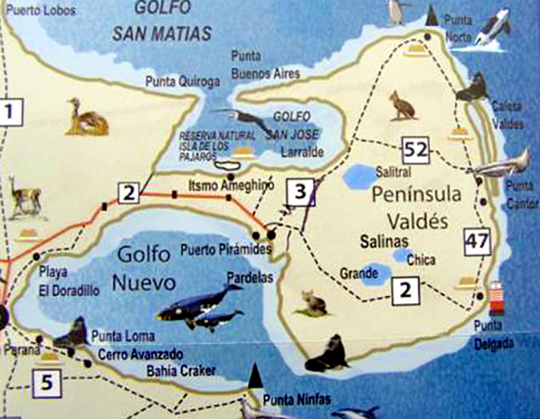
Puerto Madryn é o ponto de partida para visitar a península Valdés, com cerca de 3.625 km², na província argentina de Chubut, na costa atlântica.
No caminho para lá um pequeno centro de visitantes informa sobre a flora e fauna da península.
Península Valdés é uma reserva natural e tornou-se Patrimônio Natural Mundial integrando, assim, a lista da UNESCO em 1999. A península Valdés é formada por uma paisagem cárstica e pequenos lagos, sendo o maior localizado no ponto mais baixo da península, localizado a 35 metros abaixo do nível do mar.
A península é importante devido, principalmente, a existência de mamíferos marinhos, os quais estão presentes à beira-mar. São os lobos e elefantes marinhos
e também são avistadas baleias, em certas épocas do ano, para se reproduzir nas águas quentes e protegidas do lugar. No mar aberto também são encontradas orcas. Infelizmente quando visitamos a Península Valdés não avistamos baleias.
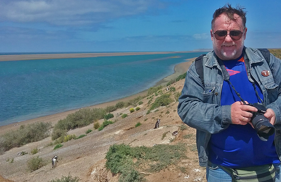
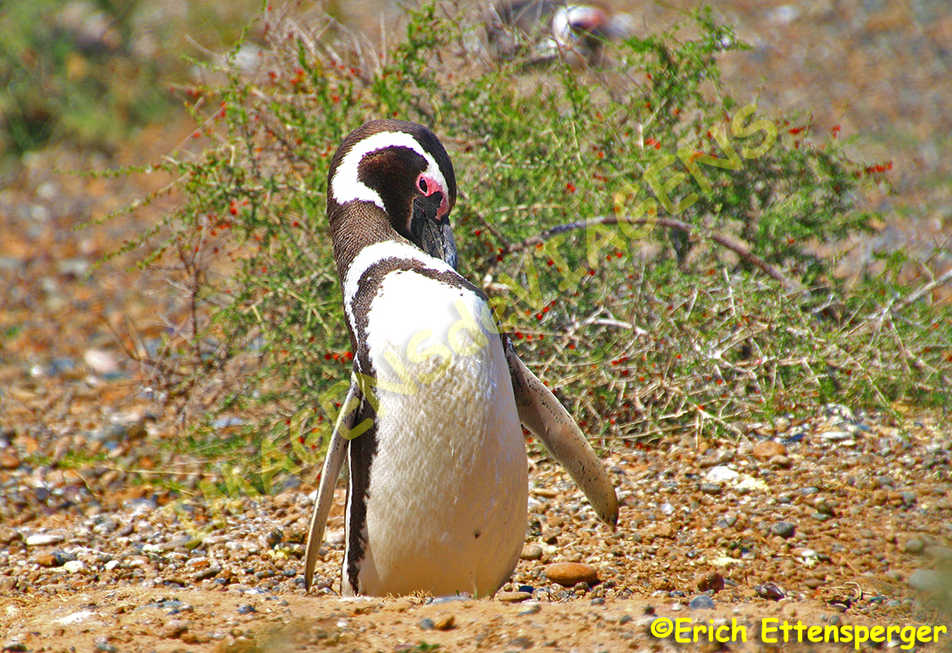
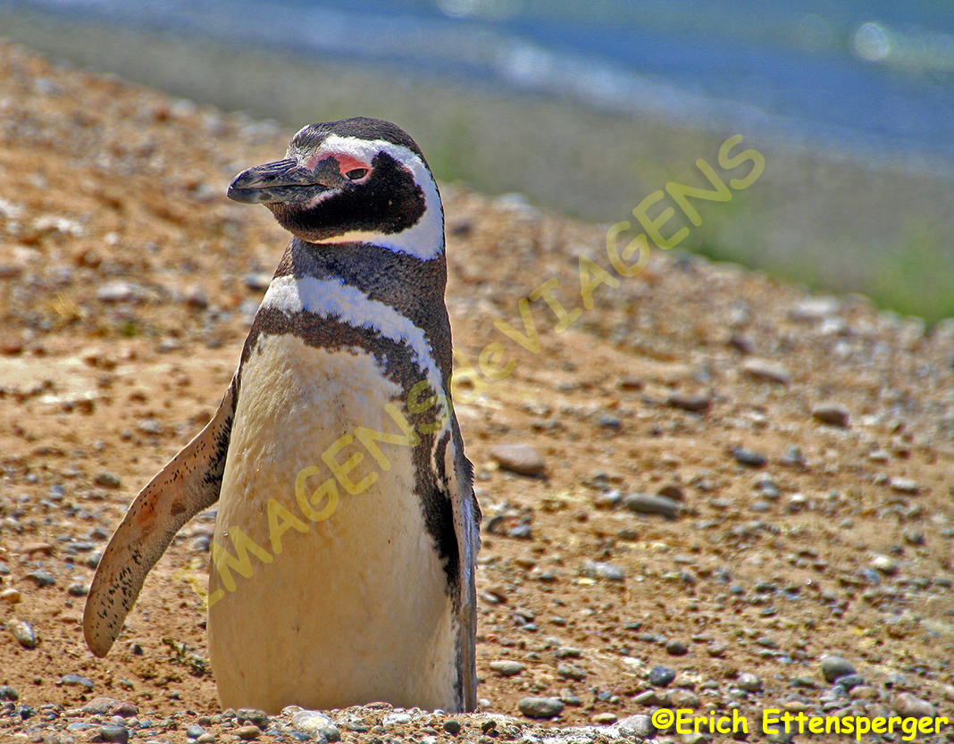
Existem muitas colônias de pinguins-de-magalhães nessa área, não são grandes, mas muito interessantes para quem se interessa por animais. Uma característica marcantes dos pinguins é que eles não sentem medo da presença humana.
Eles são capazes de se aproximarem bem perto dos visitantes, uns sessenta centímetros, sem tentar escapar ou fazer algum gesto ameaçador.
Essas colônias de pinguins-de-magalhães convivem pacificamente com os elefantes marinhos.
Há também uma variedade de aves marinhas para se observar.
O interior da península é constituída por uma estepe quente e seca com arbustos na altura do joelho e tufos de grama também seca.
Apesar do clima, o lugar é habitado por diversos animais como o nandu (parente da ema), guanacos (animal parecido com a lhama), maras (conhecida como a lebre da Patagônia), dentre outros.
O único lugar habitado da península é Puerto Piràmides, no Golfo Novo.
Se quiser conhecer mais sobre a península Valdés, clique aqui.
Observação: se você quiser continuar “viajando” com o nosso blog, clique no botão “seguir” localizado no canto inferior direito dessa página. Você receberá um email com um link para confirmar a assinatura desse blog (não paga nada). Quando clicar no link, você será direcionado para uma página em inglês (essa página explica o procedimento no caso de você desejar um dia parar de seguir o blog). A partir daí, você já está “seguindo” o blog.
Halbinsel Valdés – Paradies für Meeressäugetiere
Walisischen Siedler wanderten nach Argentinien aus auf der Suche nach billigem Land und gründeten im Jahre 1865 die kleine Stadt Puerto Madryn etwa 1.350 km südlich von Buenos Aires.
Das Leben in Patagonien war und ist jedoch nicht einfach. Es gibt einsame Prärien, brutal kalte Winter und unerbittliche Winde.
Auf dem Weg dorthin informiert das kleine Besucherzentrum über die Flora und Fauna der Halbinsel.
Sie ist ein Naturreservat und wurde 1999 von der UNESCO auf die Weltnaturerbeliste gesetzt. Die Halbinsel Valdés besteht größtenteils aus karger Landschaft und einigen kleineren Salzseen, deren größter mit 35 Metern unter dem Meeresspiegel gleichzeitig den tiefsten Punkt der Halbinsel bildet.
Von besonderer Bedeutung ist die Halbinsel wegen der Meeressäugetiere,
die sich an ihren Ufern und vor ihren Küsten tummeln.
Dies sind an der Küste Seelöwen und See-Elefanten, auch Wale werden zu Fortpflanzungszwecken zu bestimmten Jahreszeiten im Golf mit seinen wärmeren geschützten Gewässern gesichtet.
Im offenen Meer vor den Küsten der Halbinsel leben jedoch auch Schwertwale (Orcas). Zu unserer Reisezeit im Februar gab es leider keine Wale zu beobachten.
Es gibt an den Küsten mehrere Kolonien der Magellan-Pinguine ,die nicht sonderlich groß sind, aber dennoch hochinteressant für den Tierliebhaber sind.
Das Erstaunlichste an diesen Pinguinen ist das Fehlen jeglicher Scheu vor dem Menschen.
Man kann sich ihnen bis auf Armlänge nähern, ohne dass sie flüchten oder Drohgebärden zeigen.
Diese Magellan-Pinguin-Kolonien leben friedlich in unmittelbarer Nähe zu den gewaltigen See-Elefanten.
Auch gibt es eine Vielzahl von Seevögeln zu beobachten.
Das Innere der Halbinsel ist eine trockene und heiße Steppenlandschaft mit kniehohen Sträuchern und von der Sonne verbrannten, dürren Grasbüscheln.
Trotz des Klimas wird sie von zahlreichen Tieren bevölkert, wie dem Nandu (Südamerikanischer Straußenvogel), dem Guanaco (Verwandter der Lamas),
Hinweis: Falls Sie unseren “Reisen” auf dem Blog folgen wollen, dann klicken Sie unten rechts einfach auf “Weiter”, Sie werden dann zukünftig automatisch informiert.
Valdés peninsula – paradise for marine mammals
Welsh settlers migrated to Argentina in search for cheap land and founded in 1865 the small town of Puerto Madryn about 1,350 km south of Buenos Aires.
Life in Patagonia was and is not easy. There are solitary prairies, brutally cold winters and unrelenting winds.
Puerto Madryn is the starting point for visiting the Valdés peninsula, some 3,625 km² in size and 100 km away, in the Argentine province of Chubut on the Atlantic coast.
On the way to there a small visitor center informs about the flora and fauna of the peninsula.
It is a nature reserve and was set up by the UNESCO on the World Nature Reserve list in 1999. The peninsula of Valdés consists largely of karst landscape and some smaller salt lakes, the largest of which is the lowest point of the peninsula at 35 meters below sea level.
Of particular importance is the peninsula because of the sea mammals,
which are floating on their shores and their coasts.
These are on the coast sea lions and sea elephants, also whales are sighted for breeding purposes at certain seasons in the Gulf with its warmer sheltered waters.
In the open sea off the coasts of the peninsula also live orcas. At our travel time in February there were unfortunately no whales to watch.
There are several colonies of the Magellan penguins on the coasts, which are not particularly large but are nevertheless very interesting for the animal lover.
The most amazing thing about these penguins is the absence of any fear of man.
They can be approached as far as arm’s length without escaping or threatening gestures.
These Magellan penguin colonies live peacefully in the immediate vicinity of the vast sea elephants.
Also, there are a variety of seabirds to watch.
The interior of the peninsula is a dry and hot steppe landscape with knee-high shrubs and sun-dried, dry grass tufts.
Despite the climate, it is populated by numerous animals such as the Nandu (South American ostrich bird), the Guanaco (relative of the llamas),
the maras and the girdle.
The only inhabited place on the peninsula is the 400 souls village Puerto Pirámides at the Golfo Novo.
Note: If you want to follow our “Travels” on the blog, simply click on “Continue” in the lower right corner, you will be then automatically informed in the future.
Texto: Ademilton Tenório Albuquerque/Fotos e videos: Gracia Cardoso
Planeje a viagem, pois fica bem mais agradável o seu passeio. Inicie o seu planejamento verificando qual é a validade do seu Passaporte. Se for menos de seis meses ou caso não tenha passaporte verifique como fazer um novo no portal da Polícia Federal (http://www.pf.gov.br/servicos-pf/passaporte) e faça um novo. Quando receber marque uma entrevista no Consulado Americano mais próximo da sua residência para fazer a entrevista e dar o visto.
Adquira as passagens aéreas no período promocional e em seguida faça o check-in (comprei na América Airlines). Faça um Seguro de Viagem (fiz na GTA, Global Travel Assistance). Libere o cartão para compras no exterior somente no período da viagem e faça logo a reserva nos hotéis (chequei preços e reservei em Miami no Hotel Courtyard Miami Downtown e em Orlando o Rosen Inn International).
Alugue um carro para fazer seus deslocamentos (aluguei na Alamo Rent a Car com GPS, seguro e o sistema SUNPASS de pedágio – passagem automática nos pedágios e valores debitados no cartão).
Escolha os parques que vai visitar, anote o endereço correto para inserir no GPS, selecione os melhores brinquedos e adquira as entradas (comprei entradas para o Magic Kingdon e Epcot Center da Disney e para o Universal Studios e Islands of Adventure da Universal).
Compre dólares quando estiver com o preço baixo. O planejamento é uma maratona mais vale a pena, pois você vai conhecer o Estado da Flórida nos EUA e os parques mais famosos do mundo.
Em Miami não faça compras, pegue o carro, insira as rotas planejadas no GPS e vá passear na Avenida Lincoln Road em Miami Beach, no bairro de Coconut Grove, excursionar pelos pontos turísticos em veículos anfíbios da Miami Duckar, beber um chop gelado e curtir uma música caribenha no Bayside Marketplace.
Não se esqueça de comer os deliciosos pratos dos Restaurantes Dolce Italian, Fratelli Milano, Cheesecake Factory e Benihana.
Terminou os dias de Miami, faça o Check-out no hotel encare 320 km pela rodovia Ronaldo Reagan Turnpike, mais conhecida como Florida`s Turnipike até Orlando, são apenas 03:30hs de viagem. Pare no Plaza de Port St Lucie(Fort Pierce) para reabastecer o carro e fazer um lanche, depois prossiga para a cidade dos Parques.
Alterne os dias, um para compras e o outro para passear em um parque e se estiver hospedado em um hotel na Avenida International Drive saiba que esta é o ponto de encontro dos turistas com inúmeros hotéis, parques e restaurantes.
Shopping Center
Compre roupa das grifes mais famosas do mundo em uma das Lojas Ross Dress for Less, lá tem ponta de estoque com preços excelentes, vá a um dos dois outlets: Vineland Premium Outlets e International Premium ou ao Shopping Florida Mall.
Se quiser comprar eletrônicos a melhor loja é a Best Buy. Não se esqueça de passar no Walmart e frequentar alguns dos melhores Restaurantes da cidade, como o Olive Garden (massa italiana), Benihana (culinária japonesa), The Cheesecake Factory, Bubba Gump (especializado em camarão) e se quiser se lembrar do Brasil vá ao Camila`s beba uma dose de cachaça grátis tirada do barril de carvalho e peça um churrasco de picanha.
Se quiser ler mais, clique nas cidades: Orlando e Miami.
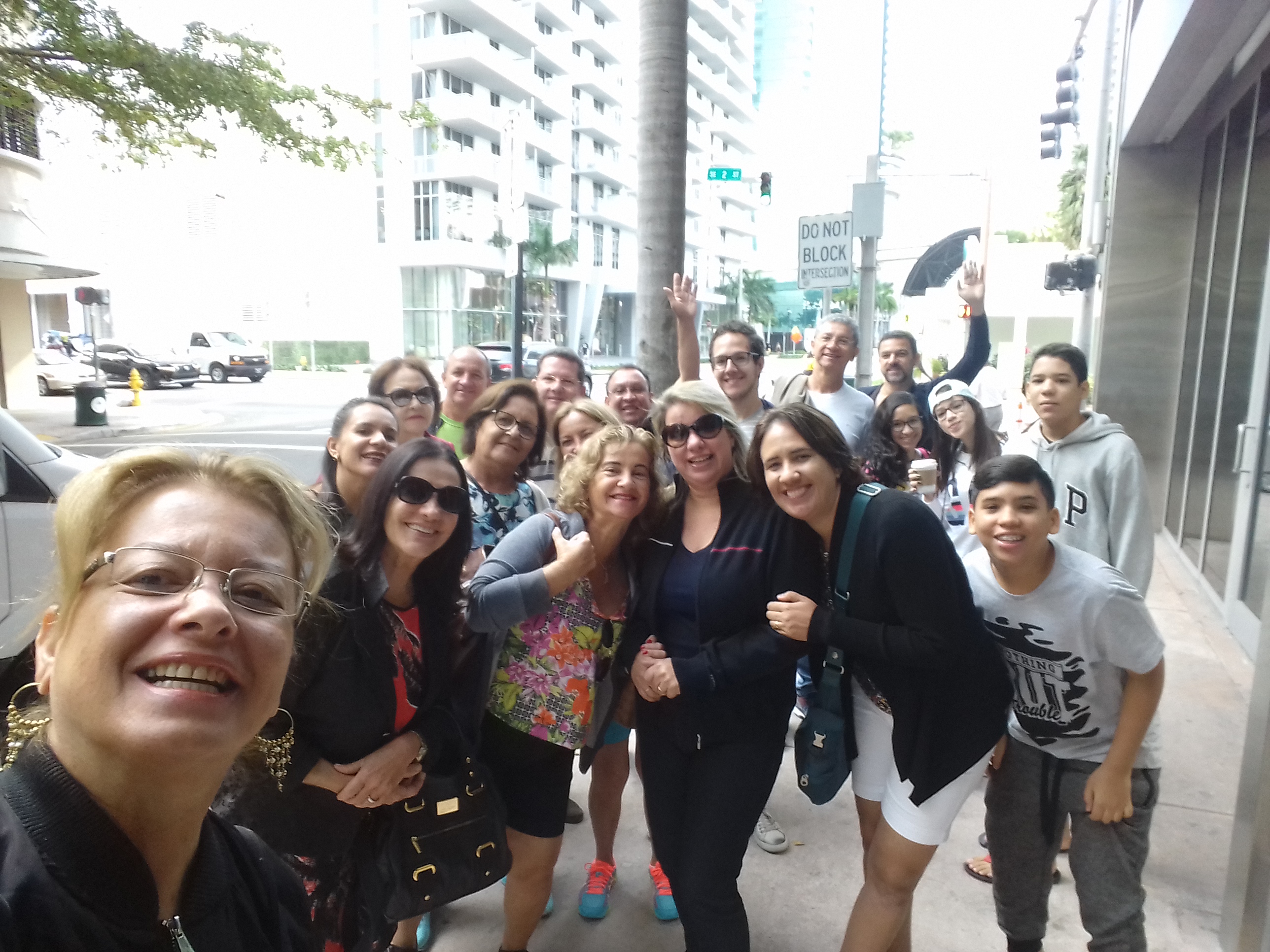
Nossos companheiros de viagem/Unsere Mitreisenden/Our fellow travelers
Observação: se você quiser continuar “viajando” com o nosso blog, clique no botão “seguir” localizado no canto inferior direito dessa página. Você receberá um email com um link para confirmar a assinatura desse blog (não paga nada). Quando clicar no link, você será direcionado para uma página em inglês (essa página explica o procedimento no caso de você desejar um dia parar de seguir o blog). A partir daí, você já está “seguindo” o blog.
Eine Reise nach Miami und Orlando
Text: Ademilton Tenório Albuquerque/Fotos und videos: Gracia Cardoso
Wir hatten alles rechtzeitig getan, was die elementaren Vorbereitungen dieser Reise angeht: REISEPÄSSE OK, Tickets OK, Reiseversicherungen und Hotelreservierungen OK, Kreditkarten freigeschaltet, Auto mit GPS gemietet und auch ausreichend Dollars gewechselt.
Die Wahl der Freizeitparks, die wir besuchen wollten, gehörte dann schon zu den eher spannenden und amüsanteren Momenten der Reiseplanung. Ich wählte folgende Parkattraktionen für uns aus:
Magic Kingdom
Epcot Center
Universal Studios
Islands of Adventure
Die Vorbereitungen der Reise sind zwar ein Marathon, aber es lohnt sich allemal, schlieβlich lernt man ja den Bundesstaat Florida der USA kennen und einige der weltweit berühmtesten Freizeitparks.
Machen Sie keine Einkäufe in Miami, holen Sie den Mietwagen ab und geben ihre Routen für ihre Ausflüge ein, machen Sie einen Spaziergang an der Lincoln Road Avenue in Miami Beach, besuchen Sie die Coconut Grove Nachbarschaft, machen Sie einen Ausflug mit Amphibienfahrzeugen (Miami Duckar Tour), trinken Sie ein kaltes Bier und genießen Sie karibische Musik im Bayside Marketplace.
Vergessen Sie nicht, die köstlichen Gerichte in den Restaurants Dolce Italiano, Fratelli Milano, Cheesecake Factory und Benihana zu probieren.
Von Miami aus fahren Sie dann in etwa 3,5 Stunden auf der Autobahn die 320 km nach Orlando zur Stadt der Freizeitparks.
Wir alternierten die Tage dort, ein Tag für Einkäufe, dann ein Tag für den Besuch eines Parkes. Untergebracht waren wir in einem Hotel an der International Drive Avenue, dies ist der Treffpunkt der Touristen mit zahlreichen Hotels, Parks und Restaurants.
Shopping Center
Kaufen Sie Kleidung der bekanntesten Marken der Welt in einem der Shoppings Ross Dress for Less zu sehr günstigen Preisen oder gehen Sie zu Vineland Premium Outlets und International Premium oder Einkaufs Mall Florida.
Das beste Elektronik-Geschäft ist das Best Buy. Vergessen Sie nicht bei Walmart einige der besten Restaurants der Stadt zu besuchen wie das Olive Garden (italienische Pasta), Benihana (japanische Küche), The Cheesecake Factory, Bubba Gump (spezialisiert auf Garnelen) und falls Sie Brasilien vermissen dann trinken Sie bei Camila`s einen gratis cachaça (Schnaps) aus dem Eichenfass und bestellen Sie ein Filet-Steak.
Tip: planen Sie sorgfältig wie und mit wem Sie reisen (Gruppe) und wie die Motivationen und Prioritäten für Shopping und/oder Sightseeing genau gelagert sind.
Nossos companheiros de viagem/Unsere Mitreisenden/Our fellow travelers
Hinweis: Falls Sie unseren “Reisen” auf dem Blog folgen wollen, dann klicken Sie unten rechts einfach auf “Weiter”, Sie werden dann zukünftig automatisch informiert.
A trip to Miami and Orlando
Text: Ademilton Tenório Albuquerque/Photos and videos: Gracia Cardoso
We had done everything in time to make the basic preparations for this trip: passports OK, tickets ok, travel insurance and hotel reservations OK, credit cards cleared, car rented with GPS and also enough dollars changed.
The choice of the recreational parks we wanted to visit was already one of the more exciting and amusing moments of the trip planning. I selected the following parks for us:
Magic Kingdom
Epcot Center
Universal Studios
Islands of Adventure
The preparations for the trip are a marathon, but it is worth it, finally, one gets to know the state of Florida of the USA and some of the world’s most famous recreation parks.
Do not go shopping in Miami, pick up your rental car and make your itinerary for your trips, take a walk on Lincoln Road Avenue in Miami Beach, visit the Coconut Grove neighborhood, take a trip with amphibian vehicles (Miami Duckar Tour), drink a cold beer and enjoy Caribbean music in Bayside.
Do not forget to taste the delicious dishes at Dolce Italiano, Fratelli Milano, Cheesecake Factory and Benihana.
From Miami, drive about 320 km to the city of leisure parks in Orlando in about 3,5 hours on the motorway.
We alternated the days there, a day for shopping, then a day for visiting a Park. We were accommodated in a hotel on International Drive Avenue, this is the meeting place for tourists with numerous hotels, parks and restaurants.
Shopping Center
Buy clothes from the most famous brands in the world in one of the Shoppings Ross Dress for Less at very reasonable rates or go to Vineland Premium Outlets and International Premium or Shopping Mall Florida.
The best electronics business is the Best Buy. Do not forget to visit some of the best restaurants in the city at Walmart, such as the Olive Garden (Italian Pasta), Benihana (Japanese Cuisine), The Cheesecake Factory, Bubba Gump (shrimp specialty) and if you miss Brazil then drink at Camila a free cachaça (schnapps) from the oak barrel and order a fillet steak.
Tip: plan carefully how and with whom you are traveling (group) and how the motivations and priorities for shopping and / or sightseeing are exactly distributed to find the right balance.
Nossos companheiros de viagem/Unsere Mitreisenden/Our fellow travelers
Note: If you want to follow our “Travels” on the blog, simply click on “Continue” in the lower right corner, you will be then automatically informed in the future.
Cuba é uma ilha muito bonita e única no Mar do Caribe. Ela surpreende com a sua histórica atmosfera “velhos tempos”, incrível natureza, música, energia positiva dos moradores, carros “Old Timers” e saborosos cocktails tradicionais. A ilha possui cerca de 1.200 quilômetros de comprimento e tem muito para se ver.
Vamos começar com a capital Havana. Hoje Havana é dividida em duas partes – a Cidade Nova e Havana La Habana Vieja (Velha Havana). A arquitetura da cidade velha é fortemente influenciada pelo período colonial espanhol. No entanto, Havana possui, definitivamente, o seu próprio e interessante espírito cubano.
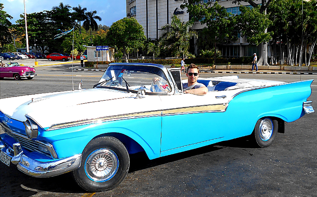
Stefano e a bandeira em Havana Velha / Stefano und Fahne in Havanna Altstadt / Stefano and flag in Havana old town. Foto/photo: Andrea VojtechovaCarros antigos em Havana Velha /Alte Autos in der Altstadt Havanna / Old cars in old Havana. Cuba e Che / Cuba und Che / Cuba and Che.
A música cubana nos acompanha através das ruas de Havana. Uma grande experiência para nós foi definitivamente ouvir o grupo original de música cubana conhecido como “Buena Vista Social Club“, que tocou em um dos bares locais.
Músicos em Havana Velha / Musikanten in der Altstadt Havanna / Musicians in the Old Havana.
Depois de visitar Havana viajamos para Cienfuegos e Trinidad, a antiga cidade colonial em Cuba localizada no centro-sul.
Carro alaranjado em Trinidad / Orangenes Auto in Trinidad / Orange car in Trinidad.
Em seguida, visitamos uma das famosas plantações de tabaco do mundo, que está localizada na parte ocidental de Cuba, no Valle de Viñales.
Campo de tabaco em Vinales / Tabak Feld in Vineales / Tobacco field in Vinales. Secagem de tabaco em Vinales / Tabaktrocknung in Vineales / Tobacco drying in Vinales.Caverna indígena em Vinales / Indianerhöhle in Vineales / Indian cave in Vinales.
A última parada em nossa viagem foi Varadero, um famoso resort turístico. Varadero está localizado na parte norte de Cuba na península de Hicacos, a 120 km de Havana. O mar azul-turquesa e areia branca em Varadero foram exatamente o que tinha imaginado. Isso faz com que Cuba do jeito que está agora, relativamente intocado pelo capitalismo e influências “ocidentais”, tão especial e definitivamente pelo menos uma vez na vida vale a pena ver – vale a pena visitar.
Nota dos editores: As rotas aéreas mais comuns para visitar Cuba, saindo do Brasil, dependendo da companhia aérea, fazem conexão em Lima, Cidade do Panamá, e Cidade do México. Pesquisamos e achamos voos de ida e volta, partindo de Natal, com conexão na Cidade do Panamá, até Havana, por volta de (USD)$ 1.000,00 (mil dólares).
Observação: se você quiser continuar “viajando” com o nosso blog, clique no botão “seguir” localizado no canto inferior direito dessa página. Você receberá um email com um link para confirmar a assinatura desse blog (não paga nada). Quando clicar no link, você será direcionado para uma página em inglês (essa página explica o procedimento no caso de você desejar um dia parar de seguir o blog). A partir daí, você já está “seguindo” o blog.
KUBA-SPEZIELLER CHARM
Kuba ist eine sehr schöne und einzigartige Insel im Karibischen Meer. Es überrascht mit seiner historischen “alten Zeit” Atmosphäre, erstaunlicher Natur, Musik, positive Energie der Einheimischen, “Old Timers” Autos und leckeren traditionellen Cocktails. Die Insel ist über 1.200km lang und bietet sehr viel zu sehen.
Beginnen wir mit der Hauptstadt Havanna. Heute ist Havanna zweigeteilt – die Neustadt Havanna und La Habana vieja (die Altstadt Havanna). Die Architektur der alten Stadt ist stark von der spanischen Kolonialzeit beeinflusst; allerdings offeriert Havanna definitiv seinen eigenen interessanten kubanischen Geist. Die kubanische Musik begleitet uns durch die Straßen in Havanna.
Stefano e a bandeira em Havana Velha / Stefano und Fahne in Havanna Altstadt / Stefano and flag in Havana old town. Foto/photo: Andrea VojtechovaCarros antigos em Havana Velha /Alte Autos in der Altstadt Havanna / Old cars in old Havana. Cuba e Che / Cuba und Che / Cuba and Che.
Eine tolle Erfahrung für uns war definitiv, die ursprüngliche kubanische Musik der Gruppe “Buena Vista Social Club” zu hören, die in einer der lokalen Musikbars spielte.
Músicos em Havana Velha / Musikanten in der Altstadt Havanna / Musicians in the Old Havana.
Nach dem Besuch von Havanna reisten wir weiter nach Cienfuegos und Trinidad, der alten Kolonialstadt im Mittel-Süd-Kuba.
Carro alaranjado em Trinidad / Orangenes Auto in Trinidad / Orange car in Trinidad.
Als nächstes besuchten wir eine der bekanntesten Tabakpflanzungen der Welt, die sich im westlichen Teil von Kuba – im Valle de Vinales befindet.
Campo de tabaco em Vinales / Tabak Feld in Vineales / Tobacco field in Vinales. Secagem de tabaco em Vinales / Tabaktrocknung in Vineales / Tobacco drying in Vinales. Caverna indígena em Vinales / Indianerhöhle in Vineales / Indian cave in Vinales.
Die letzte Station unserer Reise war Varadero, ein berühmter Urlaubsort. Varadero befindet sich im nördlichen Teil von Kuba auf der Halbinsel Hicacos, 120 km von Havanna entfernt. Das türkisfarbene Meer und der weiße Sand bei Varadero waren genau das, was wir uns vorgestellt hatten. Das macht Kuba so, wie es jetzt noch ist, relativ unberührt von Kapitalismus und “westlichen” Einflüssen, so besonders und auf jeden Fall mindestens einmal im Leben sehenswert – besuchenswert.
Hinweis: Falls Sie unseren “Reisen” auf dem Blog folgen wollen, dann klicken Sie unten rechts einfach auf “Weiter”, Sie werden dann zukünftig automatisch informiert.
CUBA-SPECIAL CHARM
Cuba is a very beautiful and unique island in the Caribbean sea.It surprises with its historic „old time“ atmosphere, amazing nature, music, positive energy of local people, “old timers” cars and delicious traditional cocktails. The island is over 1200km long and offers so much to see.
Let´s start with the capital city – Havana. Nowadays Havana is divided into two major parts – new city of Havana and la Habana vieja (the old city of Havana). The architecture of the old city is strongly influenced by Spanish colonial time; however, still Havana definitely has its interesting Cuban spirit.
Stefano e a bandeira em Havana Velha / Stefano und Fahne in Havanna Altstadt / Stefano and flag in Havana old town. Foto/photo: Andrea VojtechovaCarros antigos em Havana Velha /Alte Autos in der Altstadt Havanna / Old cars in old Havana. Cuba e Che / Cuba und Che / Cuba and Che.
The Cuban music accompanies the streets in Havana. A great experience for us was definitely to hear the original Cuban music of the group „Buena Vista Social Club“playing in one of the local music bars.
Músicos em Havana Velha / Musikanten in der Altstadt Havanna / Musicians in the Old Havana.
After visiting Havana we moved further to Cienfuegos and Trinidad, the old colonial town in the Central-South Cuba.
Carro alaranjado em Trinidad / Orangenes Auto in Trinidad / Orange car in Trinidad.
As next we visited one of the most known tobacco plantages in the world, which is located in the west part of Cuba – Valle de Vinales.
Campo de tabaco em Vinales / Tabak Feld in Vineales / Tobacco field in Vinales. Secagem de tabaco em Vinales / Tabaktrocknung in Vineales / Tobacco drying in Vinales. Caverna indígena em Vinales / Indianerhöhle in Vineales / Indian cave in Vinales.
The last stop of our trip was Varadero, a famous place for vacation spent on the beach. Varadero can be found in the Northern part of Cuba on the Hicacos peninsula, 120km from Havana. The turquoise-colored sea and white sand at Varadero were exactly what we have imagined. This all makes Cuba as it is now, untouched by capitalism and „Western“ influences, so special and definitely worth seeing at least once in a lifetime.
Note: If you want to follow our “Travels” on the blog, simply click on “Continue” in the lower right corner, you will be then automatically informed in the future.
A Ilha de Páscoa e seus misteriosos guardiões de pedra
Fotos: Marjorie Madruga
Para quem gosta de ler e conhecer lugares exóticos e longínquos, a Ilha de Páscoa ou Rapa Nui (nome indígena) é um desses lugares. Ela está situada cerca de 3700 km da costa do Chile, 4200 km do Taiti, com uma área de 16,628 hectares, dos quais 7000 hectares é Patrimônio Mundial.
Map of location of Easter Island from Google.
O Parque Nacional de Rapa Nui cobre 40% da área da ilha, cuja capital é Hanga Roa, aliás, a única cidade da ilha. São três os principais vulcões de Rapa Nui, sendo que o Rano Raraku é o que forneceu toda a pedra necessária para construir as estátuas. A Ilha Rapa Nui é o lugar mais remoto da América do Sul que é habitado.
Source of this map: http://www.easterislandquest.com/map.htmVista de Hanga Roa / Blick aufHanga Roa / View of Hanga RoaCemitério da ilha / Friedhof auf der Insel / Cemetery on the island
Primeiro, vamos entender um pouco sobre a história do lugar. Essa ilha foi vista pela primeira vez em um Domingo de Páscoa, em 1722, pelo almirante holandês Jacop Roggeveen. Segundo especialistas, os primeiros habitantes da ilha eram oriundos do povo que chegou a Fiji em 1000 a.C. aproximadamente. Os descendentes desses povos chegaram a Ilha de Páscoa por volta de 380 D.C, quando estabeleceram uma tradição de escultura monumental. O mais impressionante é que o que foi produzido lá, foi criado livre de influências externas. Foi entre os séculos X e XVI que essa sociedade construiu santuários e ergueu as colossais figuras de pedra, os moais.
O moai e a lua / Die Moai und der Mond / The moai and the moon
Antes de contarmos sobre as famosas estátuas, é bom que o leitor entenda os seguintes termos: ahu (são plataformas funerárias de pedra, localizados à beira-mar, o maior é o de Vina Pu, na costa sul da ilha) e moai (é nome dado às esculturas de pedra).
Os moais estão espalhados pela ilha, foram descobertos em torno de 900 estátuas, com dimensões variadas, tem moai de 1 metro de altura e outros que ultrapassam os nove metros. Algumas estátuas estão dispostas perto dos ahus, outras estão próximas a uma pedreira em Rano Raraku, o local é conhecido pelo nome de Fábrica dos Moais. Em se tratando dos ahus, cerca de 300 dessas plataformas foram encontradas por lá, a maioria está destruída pela ação dos homens, animais e pelas intempéries. Os principais ahus: Vaihu, Akahanga, Heki’i, Raai, Te Peu e Vinapu. Além das estátuas, você também pode observar restos de assentamentos humanos, áreas de cultivo e cerimonias.Há também outros sítios arqueológicos em forma de cavernas, com arte rupestre.
Voltando a comentar sobre os moais, quando a gente olha para as estátuas e vê aquelas figuras masculinas imensas, com grandes lóbulos auriculares, algumas com corpos decorados, ficamos pensando com que propósito elas foram construídas. Por que a maioria estão de costas para o mar, olhando fixamente para as casas e para os campos? Existem muitas teorias a respeito dessas estátuas, algumas dizem até que elas foram construídas para servirem de para-raios…
Para você ter uma ideia, veja abaixo uma lista com as principais atrações dessa ilha que atrai tantos visitantes:
Vulcão Rano Raraku – conhecido como o passeio à Fábrica de Moais
Vulcão Rano Kao / Vulkan Rano Kao / Volcano Rano KaoMoai do local conhecido como Fábrica de Moais / Moai an einem Ort bekannt als Moais Fabrik / Moai at the place known as Moais Factory
Ahu Mohai –a maioria está destruída pela ação dos homens, animais e pelas intempéries. Os principais: Vaihu, Akahanga, Heki’i, Raai, Te Peu y Vinapu. Além das estátuas, você também pode observar restos de assentamentos humanos, áreas de cultivo e cerimonias
Ahu Tongariki – área restaurada com a plataforma onde estão juntos 15 moais
Complejo Tahai-Ko Te Riku – sítio arqueológico onde é possível ver restos de assentamento humano, além de moais
Ahu Huri a Urenga – área com uma única estátua que está voltada para o nascer do sol
Ahu Akivi – esse sítio conta com 7 estátuas voltadas para poente
Ahu Ature Huki – sítio arqueológico situado na praia de Anakena
Ahu Nau Nau – sítio localizado na praia de Anakena, os moais dessa área são tatuados e usam vestimentas
Moais na praia de Anakena / Moais am Strand Anakena / Moais at the beach Anakena
Playa Ovahe – praia ideal para praticar mergulho e nudismo.
Orongo – uma vila de natureza cerimonial. A visita é interessante devido à sua localização e arquitetura.
A Ilha de Páscoa oferece várias opções de passeios: fazer trilha de bicicleta, a pé, a cavalo, ir à praia, apreciar as belas paisagens das ilhas, passeio de barco com mergulho, dentre outros. A gastronomia da ilha atrai quem gosta de peixes, tem um atum grelhado, ceviche.Se você quiser relatos detalhados sobre visitas à ilha, recomendamos que visitem o blog Revivendo viagens e o blog A Mochila e o Mundo.
por do sol na ilha / Sonnenuntergang auf der Insel / Sunset on the islandAltar nas proximidades de PAPA TATAKU POKI / Altar in der Nähe von PAPA Tataku POKI / Altar nearby PAPA TATAKU POKI
Como chegar lá? Há voos saindo de Santiago e tem a duração de 5 horas e 35 minutos, custa em torno de US$ 1.300,00. Mas, se você ficar de olho, quem sabe consegue comprar o bilhete aéreo quando a LATAM fizer uma promoção…
Se quiser conhecer mais sobre a Ilha de Páscoa, visite os sites seguintes: Portal Rapa Nui e o da UNESCO.
Gostaríamos de agradecer a amiga Marjorie Madruga por ter nos fornecido as belas fotografias que ilustram esse post.
Marjorie Madruga e os Moais / Marjorie Madruga und Moais / Marjorie Madruga and MoaisAs belas cores da Ilha de Páscoa / Schöne Farben auf der Osterinsel / Beautiful colors on Easter Island
Observação: se você quiser continuar “viajando” com o nosso blog, clique no botão “seguir” localizado no canto inferior direito dessa página. Você receberá um email com um link para confirmar a assinatura desse blog (não paga nada). Quando clicar no link, você será direcionado para uma página em inglês (essa página explica o procedimento no caso de você desejar um dia parar de seguir o blog). A partir daí, você já está “seguindo” o blog.
Die Osterinsel und seine geheimnisvollen steinernen Wächter
Fotos: Marjorie Madruga
Wer gerne über exotische und weit entfernte Orte lesen und lernen möchte für den ist die Osterinsel oder auch Rapa Nui, von den Einheimischen so genannt, einer dieser Orte. Sie ist etwa 3700 km von der Küste Chiles, 4200 km von Tahiti entfernt mit einer Fläche von 16,628 Hektar, wovon 7000 Hektar Weltkulturerbe sind.
Map of location of Easter Island from Google.
Der Nationalpark Rapa Nui umfasst 40% der Inselfläche mit der Hauptstadt Hanga Roa, die einzige Stadt auf der Insel. Es gibt drei Hauptvulkane auf Rapa Nui wobei es der Rano Raraku ist, der all das Gestein liefert, das für den Bau der Statuen benötigt wird. Die Osterinsel ist der am weitesten von Südamerika entfernte und gleichsam bewohnte Ort.
Source of this map: http://www.easterislandquest.com/map.htmVista de Hanga Roa / Blick aufHanga Roa / View of Hanga RoaCemitério da ilha / Friedhof auf der Insel / Cemetery on the island
Lassen Sie uns zunächst ein wenig die Geschichte dieses Ortes verstehen lernen. Diese Insel wurde zum ersten Mal im Jahre 1722 vom niederländische Admiral Roggeveen Jacop gesichtet und zwar am Ostersonntag. Nach Einschätzung von Experten kamen die ersten Bewohner der Insel etwa 1000 vor Christus von den Fidschi-Inseln. Die Nachkommen dieser Menschen kamen rund 380 nach Christus auf die Osterinsel und etablierten diese Tradition der monumentalen Skulpturen. Auffällig ist, dass das, was dort produziert wurde, frei von jeglichen äußeren Einflüssen war. Zwischen dem 10. Und 16. Jahrhundert erschuf diese Gesellschaft Schreine und errichtete diese kolossalen Steinfiguren, die Moai.
O moai e a lua / Die Moai und der Mond / The moai and the moon
Bevor wir über die berühmten Statuen sprechen, ist es gut, folgenden Begriffe zu verstehen: ahu (sind Steingrab Plattformen am Meer gelegen, die größte ist die Vina Pu an der Südküste der Insel) und Moai (Name für die Steinskulpturen).
Die Moais sind rund um die Insel verstreut, es wurden um die 900 Statuen entdeckt mit unterschiedlichen Abmessungen. Es gibt Moais mit nur 1 Meter Höhe und andere mit mehr als neun Metern. Einige Statuen befinden sich in der Nähe von „ahus“, andere sind in der Nähe eines Steinbruchs bei Rano Raraku, ein Ort bekannt als Fabrik der Moais. Im Falle der ahus wurden dort etwa 300 dieser Stein-Plattformen gefunden, die meisten waren jedoch durch die Einwirkung von Menschen, Tieren und dem Wetter zerstört. Die wichtigsten ahus: Vaihu, Akahanga, Heki’i, Raai, Peu und Vinapu Te. Neben den Statuen können Sie auch die Reste menschlicher Siedlungen, Acker- und Zeremonienflächen begutachten. Weitere archäologische Stätten existieren in Form von Höhlen mit Felsmalereien. Beim Betrachten dieser riesigen männlichen Figuren, manche dekoriert, mit den groβen Ohrläppchen fragt man sich unweigerlich zu welchem Zweck sie konstruiert wurden. Warum sind sie mit dem Rücken zum Meer mit diesem starren Blick auf die Häuser und Felder? Es gibt viele Theorien über diese Statuen, manche besagen sogar, daβ sie gebaut wurden, um als Blitzableiter zu dienen.
Hier nun eine Liste der wichtigsten Attraktionen dieser Insel, die so viele Besucher magisch anzieht:
Rano Raraku – bekannt als der Ausflug zur Moai-Fabrik
Vulcão Rano Kao / Vulkan Rano Kao / Volcano Rano KaoMoai do local conhecido como Fábrica de Moais / Moai an einem Ort bekannt als Moais Fabrik / Moai at the place known as Moais Factory
Ahu Mohai – gröβtenteils durch Mensch, Tier und dem Wetter zerstört. Die Haupt Ahus: Vaihu, Akahanga, Heki’i, Raai, Te Peu y Vinapu. Neben den Statuen können auch Reste menschlicher Ansiedlungen, Anbauflächen und Zeremonienstätten begutachtet werden.
Ahu Tongariki – restaurierte Plattform zusammen mit 15 Moais
Complejo Tahai-Ko Te Riku – archäologische Stätte mit Überresten menschlicher Siedlung sowie Moai
Ahu Huri a Urenga – Bereich mit einer einzigen Statue dem Sonnenaufgang zugewandt
Ahu Akivi – 7 Statuen nach Westen ausgerichtet
Ahu Ature Huki – archäologische Stätte am Strand von Anakena gelegen
Ahu Nau Nau – auch direkt am Strand von Anakena gelegen, die Moais tätowiert und tragen Kleider
Moais na praia de Anakena / Moais am Strand Anakena / Moais at the beach Anakena
Playa Ovahe – idealer Strand zum Tauchen und Nudismus
Orongo – ein Dorf von zeremoniellen Natur. Der Besuch ist interessant wegen seiner Lage und Architektur
Die Osterinsel bietet verschiedenste Aktivitäten: Radtouren, wandern, reiten, am Strand spazieren, genießen Sie die schöne Landschaften der Inseln, Bootstouren mit schnorcheln usw. Die Küche der Insel zieht diejenigen an, die Fisch mögen, einen gegrillten Thunfisch z.B. oder
por do sol na ilha / Sonnenuntergang auf der Insel / Sunset on the islandAltar nas proximidades de PAPA TATAKU POKI / Altar in der Nähe von PAPA Tataku POKI / Altar nearby PAPA TATAKU POKI
Wie kommt man hin? Es gibt Flüge von Santiago mit einer Dauer von 5 Stunden und 35 Minuten und Kosten von etwa 1.300 US $ . Aber Sie können das Ganze ja ganz einfach im Auge behalten und warten auf eine Werbungsaktion der LATAM.
Falls Sie mehr über die Osterinsel erfahren möchten, besuchen Sie einfach die folgenden Websites: Portal Rapa Nuiund die der UNESCO.
Wir möchten an dieser Stelle unserer Freundin Marjorie Madruga danken für die schönen Fotografien, die diesen Beitrag illustrieren.
Marjorie Madruga e os Moais / Marjorie Madruga und Moais / Marjorie Madruga and MoaisAs belas cores da Ilha de Páscoa / Schöne Farben auf der Osterinsel / Beautiful colors on Easter Island
Hinweis: Falls Sie unseren “Reisen” auf dem Blog folgen wollen, dann klicken Sie unten rechts einfach auf “Weiter”, Sie werden dann zukünftig automatisch informiert.
The Easter Island and its mysterious stone guardians
Photos: Marjorie Madruga
If you would like to read and learn about exotic and distant places, the Easter Island, also called Rapa Nui by the locals, is one of these places. It is about 3700 km from the coast of Chile, 4200 km from Tahiti with an area of 16,628 hectares, of which 7000 hectares are world heritage sites.
Map of location of Easter Island from Google.
The National Park Rapa Nui covers 40% of the island with the capital Hanga Roa, the only town on the island. There are three main volcanoes on Rapa Nui, the Rano Raraku is the one which supplied all the rocks needed for the construction of the statues. The Easter Island is the most remote and inhabited place from South America.
Source of this map: http://www.easterislandquest.com/map.htmVista de Hanga Roa / Blick aufHanga Roa / View of Hanga RoaCemitério da ilha / Friedhof auf der Insel / Cemetery on the island
Let us look onto the history of this place. This island was first seen in 1722 by the Dutch Admiral Roggeveen Jacop on the Easter Sunday. According to experts the first inhabitants of the island came from the Fiji Islands about 1000 B.C. The descendants of these people came to the Easter Island around 380 A.D. and established this tradition of monumental sculptures. It is striking that what was produced there was free from any external influences. Between the 10th and 16th centuries this society created shrines and built these colossal stone figures, the Moais.
O moai e a lua / Die Moai und der Mond / The moai and the moon
Before talking about the famous statues, it is good to understand the following terms: ahu (are stone grave platforms located close to the sea, the largest is the Vina Pu on the south coast of the island) and Moai (name for the stone sculpture).
The Moais are scattered around the island, around 900 statues have been discovered with different dimensions. There are Moais with only one meter height and others with more than nine meters. Some statues are located near “ahus”, others are near a quarry close to Rano Raraku, a place known as the Moais factory. In the case of the ahus, about 300 of these stone platforms were found there, but most were destroyed by the effects of humans, animals and the weather. The most important ahus: Vaihu, Akahanga, Heki’i, Raai, Peu and Vinapu Te. In addition to the statues you can also examine the remains of human settlements, cultivation and ceremonial areas. Other archaeological sites exist in form of caves with Rock paintings. Looking at these huge male figures, some decorated and with the big earlobes, you inevitably ask youself what purpose they were designed for. Why do most of them have their backs to the sea, staring at the houses and the fields? There are many theories about these statues, some even say they were built to serve as lightning rod.
Here is a list of the main attractions on the island, which attracts so many visitors magically:
Rano Raraku – known as the Moai factory
Vulcão Rano Kao / Vulkan Rano Kao / Volcano Rano KaoMoai do local conhecido como Fábrica de Moais / Moai an einem Ort bekannt als Moais Fabrik / Moai at the place known as Moais Factory
Ahu Mohai – largely destroyed by humans, animals and the weather. The main ahus: Vaihu, Akahanga, Heki’i, Raai, Te Peu y Vinapu. In addition to the statues the remains of human settlements, cultivation areas and ceremonial services can also be examined.
Ahu Tongariki – restored platform together with 15 Moais
Complejo Tahai-Ko Te Riku – archaeological site with remains of human settlement as well as Moais
Ahu Huri a Urenga – area with a single statue facing the sunrise
Ahu Akivi – 7 statues aligned to the west
Ahu Ature Huki – archaeological site located at the beach of Anakena
Ahu Nau Nau – also located directly at the beach of Anakena with Moais tattooed and wearing clothes
Moais na praia de Anakena / Moais am Strand Anakena / Moais at the beach Anakena
Playa Ovahe – beach for diving and nudism
Orongo – a village of ceremonial nature. The visit is interesting because of its location and architecture
The island offers a variety of activities: cycling, hiking, horseback riding, walking alongside the beach, enjoying the beautiful landscapes of the islands, boat trips with snorkeling, etc. The island’s cuisine attracts those who like fish, for example grilled tuna or Ceviche. For detailed reports about the island we recommend visiting the Blog Revivendo Viagens and the Blog A Mochila e o Mundo.
por do sol na ilha / Sonnenuntergang auf der Insel / Sunset on the islandAltar nas proximidades de PAPA TATAKU POKI / Altar in der Nähe von PAPA Tataku POKI / Altar nearby PAPA TATAKU POKI
How to get there? There are flights from Santiago with a duration of 5 hours and 35 minutes and costs around US $ 1,300.00. But you can keep an eye on the whole thing and just wait for a LATAM advertising campaign.
If you would like to know more about the Island simply visit the following websites: Portal Rapa Nui and the UNESCO website.
We would like to thank our friend Marjorie Madruga for the beautiful photographs that illustrate this article.
Marjorie Madruga e os Moais / Marjorie Madruga und Moais / Marjorie Madruga and MoaisAs belas cores da Ilha de Páscoa / Schöne Farben auf der Osterinsel / Beautiful colors on Easter Island
Note: If you want to follow our “Journeys” on the blog, simply click on “Continue” in the lower right corner, you will be automatically informed in the future.
Apresentar lugares visitados ao redor do mundo e proporcionar um intercâmbio de informações com nossos visitantes./Display places visited around the world and provide an exchange of information with our visitors./Weltweit besuchte Orte vorstellen und einen Informationsaustausch mit unseren Besuchern anregen.