Sergipe é um estado brasileiro localizado na região Nordeste. Sua capital é Aracaju. São Cristóvão é um município sergipano, com um população de aproximadamente, 85 000 habitantes, situado em torno de 24 km de Aracaju e é lá onde se encontra um dos mais belos conjuntos arquitetônicos, urbanísticos e paisagísticos do Brasil.
Trata-se de um relevante exemplar de núcleo urbano colonial criado durante o período no qual Portugal e Espanha estiveram sob a mesma coroa, entre os anos de 1580 e 1640, nos reinados de Dom Felipe II e Felipe III, durante a União Ibérica.
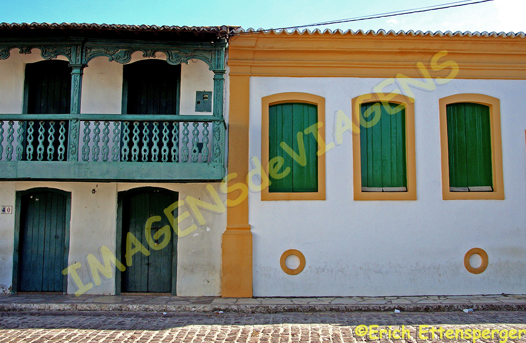
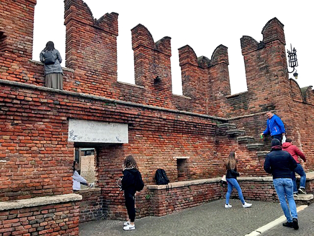
São Cristóvão foi fundada em 1 de janeiro de 1590, por Cristóvão de Barros e foi a primeira capital de Sergipe e é a quarta mais antiga cidade brasileira. Ela possui uma parte alta e uma baixa, está localizada à margem do rio Paramopama, afluente do rio Vaza-Barris e seu traçado urbano foi determinado pela localização de suas construções religiosas. O seu patrimônio histórico é constituído pela arquitetura colonial,
Do lado esquerdo, Sobrado da Rua da Matriz com balcão corrido,
Consideramos São Cristóvão um relevante atrativo cultural do Brasil e por isso, ele integra o nosso livro 66 x Brasil.
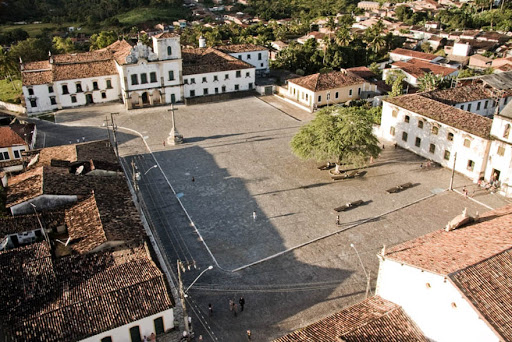
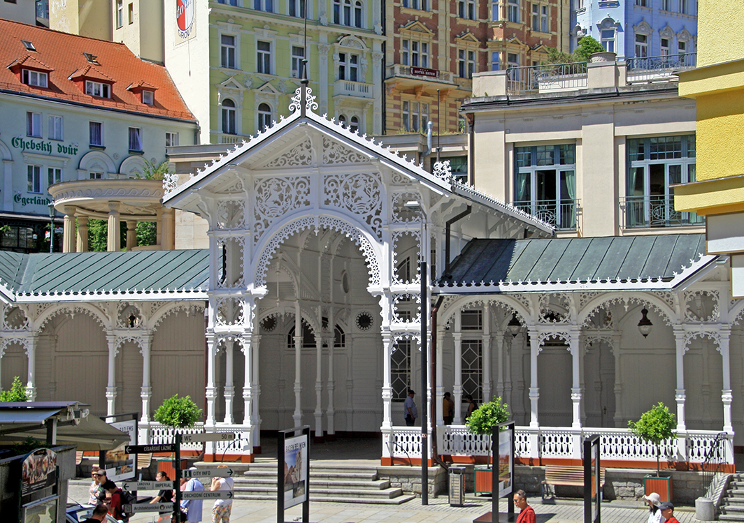
A Praça de São Francisco é a pérola desse lugar, considerada a “é um conjunto monumental excepcional e homogêneo composto por edifícios públicos e privados que representam o período de união das coroas portuguesa e espanhola” de acordo com a UNESCO. Essa praça foi desenhada seguindo o conceito de “Plaza Mayor” muito utilizado nas cidades colonizadas pela Espanha nas Américas, também chamada América Hispânica.
Ela é constituída de uma área aberta circundada por antigas edificações, como a Igreja e Santa Casa de Misericórdia,
Santa Casa da Misericórdia e Igreja Santa Izabel
o Palácio Provincial,
Antigo Palácio Provincial – Museu Histórico de Sergipe
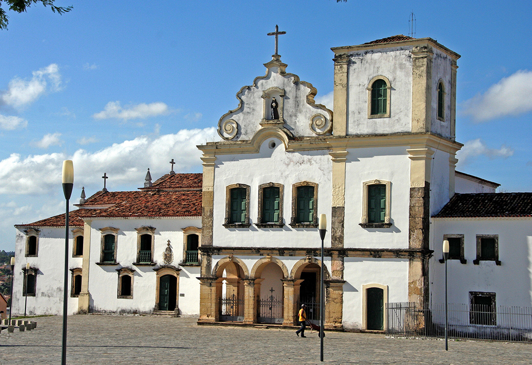
a Igreja e Convento de São Francisco,
Igreja e Convento de São Francisco
além de casas construídas em diferentes momentos históricos. Há edifícios públicos e privados. Em resumo, com base na literatura pesquisada e em observações realizadas no local, a Praça de São Francisco é um importante exemplar de um conjunto que seguiu os padrões de construção portugueses coloniais e a legislação espanhola da época. O mais importante dos edifícios dessa praça é o complexo da Igreja e o Convento de São Francisco.
Igreja e Convento de São Francisco
Essa praça é o coração da cidade de São Cristóvão, onde diversas atividades sociais e culturais são realizadas.
São Cristóvão é definitivamente uma sugestão de passeio para os que gostam de conhecer um pouco mais sobre a história do Brasil.
Observação: se você quiser continuar “viajando” com o nosso blog, clique no botão “seguir” localizado no canto inferior direito dessa página. Você também pode “viajar”pelo Brasil conhecendo nosso livro impresso 66 x Brasil e sua versão digital66 Belezas do Brasil.
São Cristóvão – ein Besuch für Geschichtsliebhaber
Sergipe ist ein brasilianischer Staat im Nordosten. Die Hauptstadt ist Aracaju. São Cristóvão ist eine Gemeinde in Sergipe mit ca. 85.000 Einwohnern, rund 24 km von Aracaju entfernt. Hier befindet sich einer der schönsten Architektur-, Stadt- und Landschaftskomplexe Brasiliens.
Es ist ein relevantes Beispiel für einen kolonialen, städtischen Kern, der in der Zeit geschaffen wurde als Portugal und Spanien zwischen 1580 und 1640 unter Dom Felipe II. und Felipe III. unter derselben Krone standen, der Iberischen Union.
São Cristóvão wurde am 1. Januar 1590 von Cristóvão de Barros gegründet und war die erste Hauptstadt von Sergipe und die viertälteste Stadt Brasiliens. Die Stadt ist auf einem höheren und einem tieferen Teil am Ufer des Paramopama-Flusses gelegen, einem Nebenfluss des Vaza-Barris-Flusses, und ihr städtischer Grundriss wurde durch die Lage seiner religiösen Gebäude vorgegeben.
Das historische Erbe besteht aus Kolonialarchitektur,
auf der linken Seite ein Sobrado (Haus mit Dachgeschoss) der Rua da Matriz mit typischem Balkon,
Wir betrachten São Cristóvão als eine relevante kulturelle Attraktion in Brasilien und ist gerade deswegen Teil unseres Buches 66 x Brasilien.
Der Platz Praça de São Francisco ist die Perle dieses Ortes und gilt laut UNESCO als „außergewöhnlicher und homogener monumentaler Komplex aus öffentlichen und privaten Gebäuden, welche die Zeit der Vereinigung der portugiesischen und spanischen Kronen darstellen“.
Dieser Platz wurde nach dem Konzept der „Plaza Mayor“ entworfen, die in den Städten, welche von Spanien in Amerika kolonisiert wurden und auch als Hispanic America bezeichnet werden, weit verbreitet ist.
Er besteht aus einem offenen Bereich, der von alten Gebäuden wie der Kirche und der Santa Casa de Misericórdia,
Santa Casa da Misericórdia e Igreja Santa Izabel
dem Provinzpalast,
Antigo Palácio Provincial – Museu Histórico de Sergipe
der Kirche und dem Kloster von São Francisco umgeben ist,
Igreja e Convento de São Francisco
sowie Häusern, die in verschiedenen historischen Momenten gebaut wurden.
Es gibt öffentliche und private Gebäude. Zusammenfassend ist der Praça de São Francisco, basierend auf der recherchierten Literatur und den vor Ort gemachten Beobachtungen, ein wichtiges Beispiel für ein Architektur-Set, das den portugiesischen Kolonialbaustandards und der spanischen Gesetzgebung der damaligen Zeit entsprach.
Das wichtigste Gebäude auf diesem Platz ist der Kirchenkomplex und das Kloster von São Francisco.
Igreja e Convento de São Francisco
Der Platz ist das Herz der Stadt São Cristóvão, wo verschiedene soziale und kulturelle Aktivitäten stattfinden.
Der Besuch von São Cristóvão ist eine Tour, die an einem Tag durchgeführt werden kann und dem Touristen somit die Möglichkeit bietet, einen Ort mit dem São Francisco Platz zu besuchen, der seit 2010 zum Weltkulturerbe der UNESCO gehört.
Darüber hinaus verfügt das Institut für nationales historisches und künstlerisches Erbe – IPHAN über zahlreiche Vermögenswerte, die bezüglich diesem Standort seit 1967 aufgeführt sind.
São Cristóvão ist definitiv ein Tourvorschlag für diejenigen, die etwas mehr über die Geschichte Brasiliens erfahren möchten.
Hinweis: Falls Sie unserem Blog folgen wollen, dann klicken Sie unten rechts einfach auf “Weiter”, Sie werden dann zukünftig automatisch informiert. Sie können auch durch Brasilien reisen und unser Buch 66 SEHENSWÜRDIGKEITEN IN BRASILIEN kennenlernen und 66 x Brazil – A Mosaic of Beauties.
São Cristóvão – a visit for history lovers
Sergipe is a Brazilian state in the northeast. The capital is Aracaju. São Cristóvão is a municipality in Sergipe with approx. 85,000 inhabitants around 24 km from Aracaju. One of the most beautiful architectural, urban and landscape complexes in Brazil is located here.
It is a relevant example of a colonial, urban core that was created when Portugal and Spain between 1580 and 1640 under Dom Felipe II and Felipe III. were under the same crown, the Iberian Union.
São Cristóvão was founded on January 1st 1590 by Cristóvão de Barros and was the first capital of Sergipe and the fourth oldest city in Brazil. The city is located on a higher and a lower part on the banks of the Paramopama River, a tributary of the Vaza Barris River, and its urban layout was determined by the location of its religious buildings.
The historical legacy consists of colonial architecture,
on the left a sobrado (house with attic) on Rua da Matriz with a typical balcony,
We consider São Cristóvão to be a relevant cultural attraction in Brazil and that’s why it’s part of our book 66 x Brazil.
The Praça de São Francisco square is the pearl of this place and, according to UNESCO, is an “extraordinary and homogeneous monumental complex of public and private buildings that represent the time of the union of the Portuguese and Spanish crowns”.
This square was designed according to the concept of the “Plaza Mayor”, which is widespread in the cities that were colonized by Spain in America and are also known as Hispanic America.
It consists of an open area surrounded by ancient buildings such as the Church and Santa Casa de Misericórdia,
Santa Casa da Misericórdia e Igreja Santa Izabel
the Provincial Palace,
Antigo Palácio Provincial – Museu Histórico de Sergipe
Church and Convent of São Francisco,
Igreja e Convento de São Francisco
as well as houses that were built at different historical moments.
There are public and private buildings. In summary, based on the researched literature and the observations made on site, the Praça de São Francisco is an important example of an architectural set that complied with the Portuguese colonial building standards and the Spanish legislation of the time.
The main building in this square is the São Francisco Church Complex and Convent.
Igreja e Convento de São Francisco
The square is the heart of the city of São Cristóvão, where various social and cultural activities take place.
The visit of São Cristóvão is a tour that can be done in one day and thus offers the tourist the opportunity to visit a place with the São Francisco Square, which has been a UNESCO World Heritage Site since 2010.
In addition, the Institute for National Historical and Artistic Heritage – IPHAN has numerous assets listed regarding this location since 1967.
São Cristóvão is definitely a tour suggestion for those who want to learn a little more about the history of Brazil.
Note: If you want to follow our “Travels” on the blog, simply click on “Seguir” in the lower right corner, you will be then automatically informed in the future. You can continue traveling with us with our book Brazil´s 66 Beautiful Sites and 66 x Brazil – A Mosaic of Beauties.
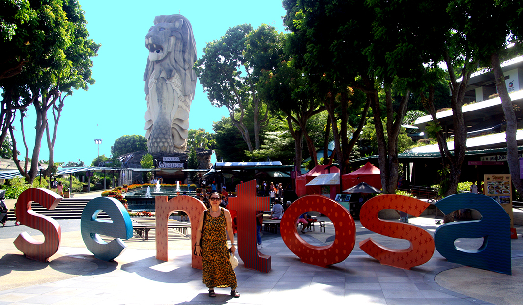
Cingapura é uma cidade-estado constituída por 63 ilhas, sendo que uma delas chama-se Sentosa, distante em torno de meia hora de Cingapura.
Quando chegamos a ilha,
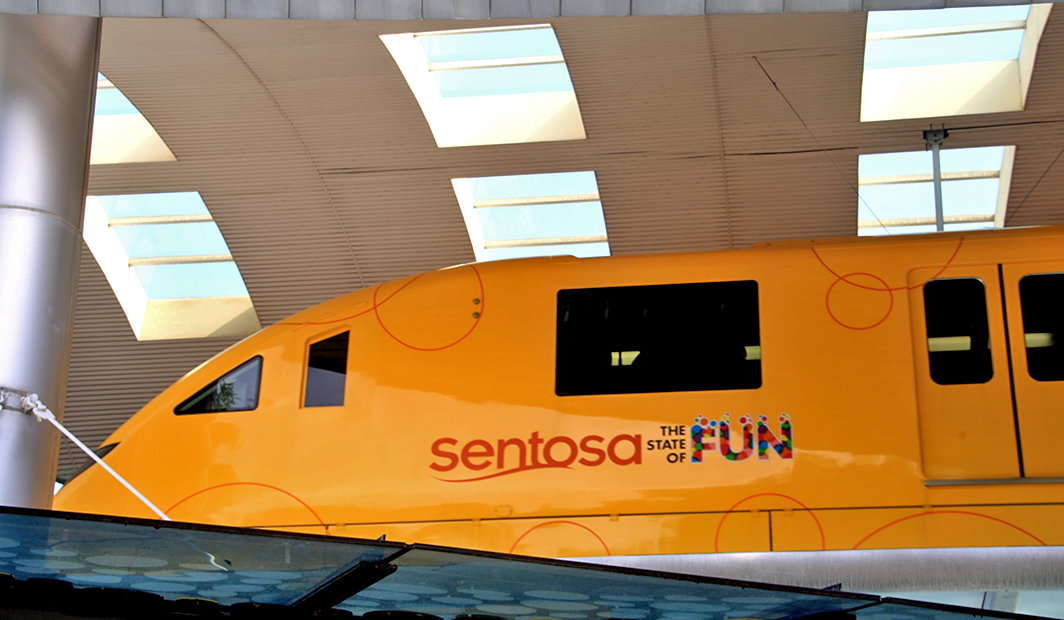
Erich disse que Sentosa é a Disneylândia de Cingapura.
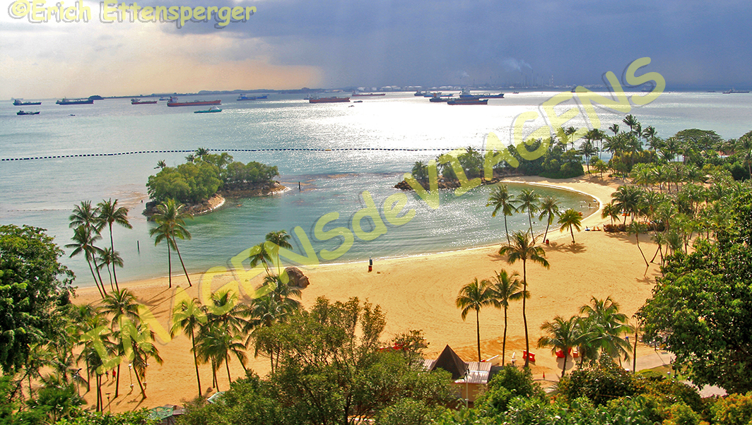
E é verdade. É lá que localiza-se o parque de diversões chamado “Universal” com muitos brinquedos, shows, piscinas com tobogãs, dentre outros. Há trilhas para serem percorridas, resorts de luxo, casas de veraneio, bares e restaurantes, além de três praias.
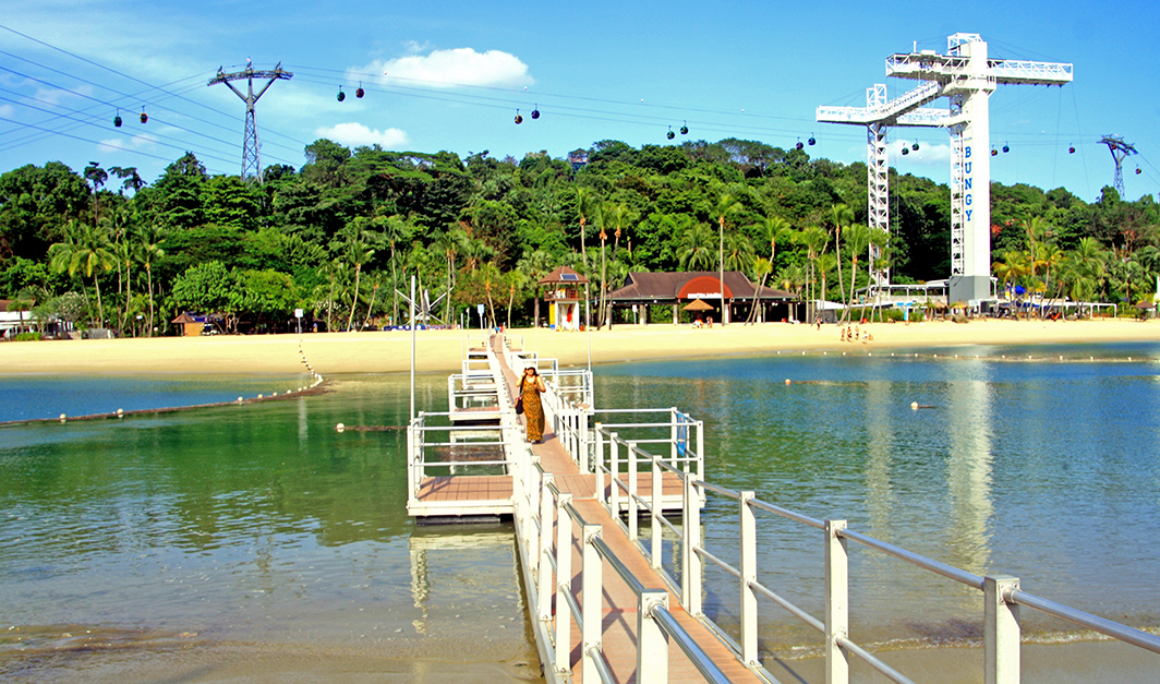
Visitamos a praia chamada Siloso Beach é linda!
Trata-se de uma praia artificial, com águas tranquilas, propícia para banhos de mar refrescantes.
A praia tem uma ótima infraestrutura de lazer,
além de equipamentos de diversão como uma alta torre para prática de Bungee-Jumping.
Sentosa possui muitas atrações, como o Parque das Águas, o Parque das Borboletas e o Reino dos Insetos, a Ilha dos Golfinhos, o Forte de Siloso e a Trilha Suspensa do Forte do Siloso. Além desses parques existe o Museu Madame Trussaud Cingapura, o Lago dos Sonhos, o Aquário, são tantas as atrações! Para quem mora em Cingapura e vai sempre se divertir em Sentosa, vale a pena ter a carteira de sócio, para poder usufruir de tudo com um melhor preço. A ilha é também um local para a realização de eventos sociais e culturais.
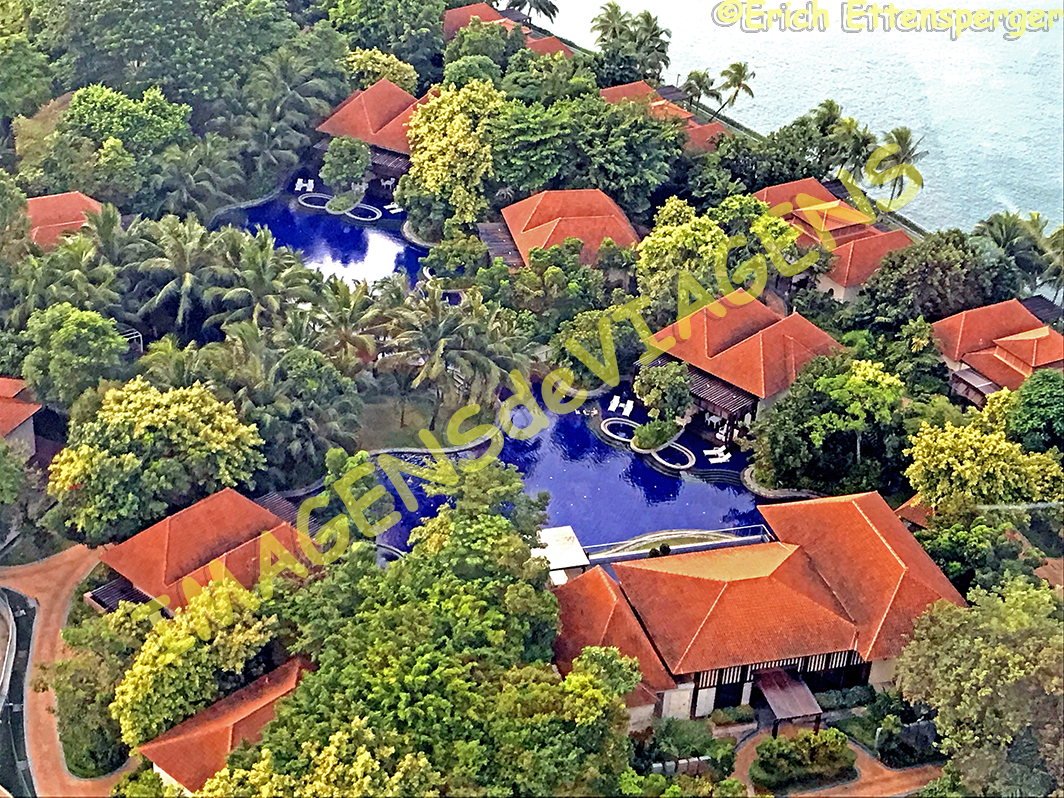
Essa ilha possui também muitas opções de hospedagens, são resorts e hotéis sensacionais! Veja aqui mais sobre eles.
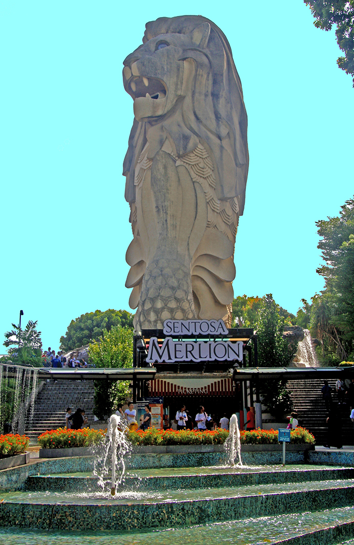
Em Sentosa existe uma grande estátua de Merlion, um dos símbolos de Cingapura, trata-se da representação de uma figura que é uma cabeça de leão com corpo de peixe, ele é considerado o guardião da prosperidade.
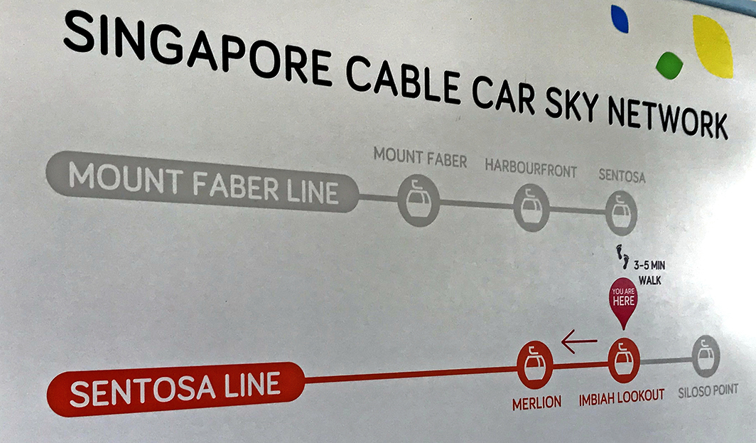
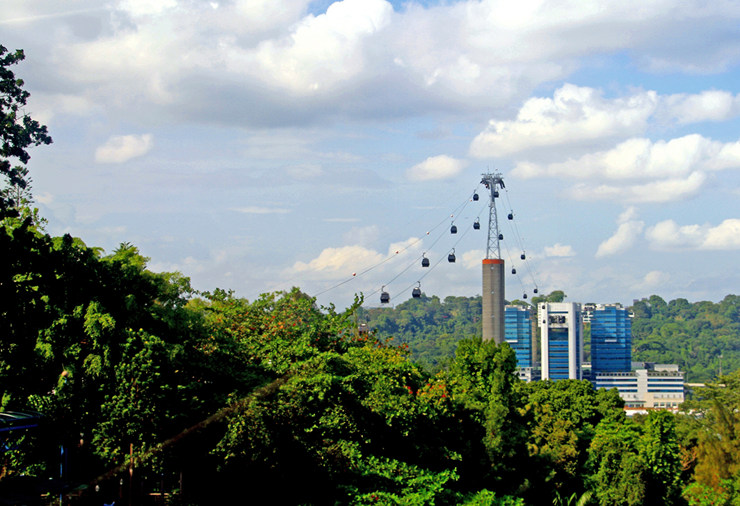
O passeio até Sentosa é bem interessante, começando a partir do uso do teleférico,
de onde se tem uma vista bonita da ilha.
Sentosa é tão, tão interessante que, se você se gostaria de conhecer mais sobre esse lugar de diversões de Cingapura, clique aqui para conhecer detalhes.
Se você quer passar férias em lugar para se divertir, Sentosa é definitivamente o local ideal para relaxar quando a pandemia passar!
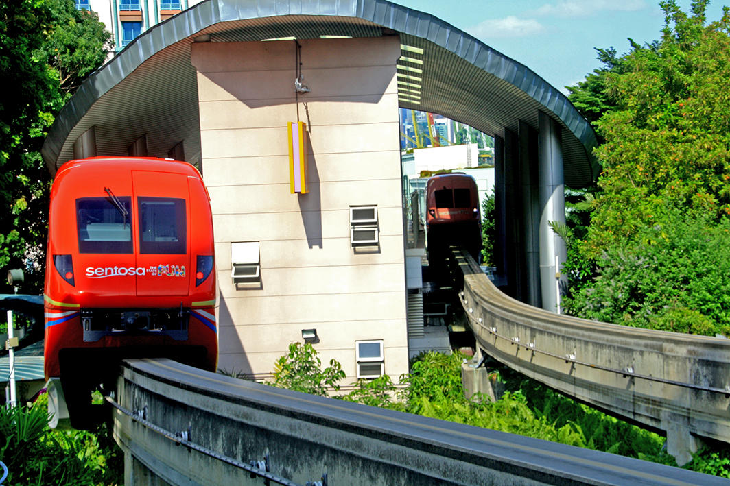
Como chegar em Sentosa saindo da área do Marina Bay Sands Hotel: pegar o ônibus 97, depois o monorail e por último o teleférico que conduz até Sentosa.
Observação: se você quiser continuar “viajando” com o nosso blog, clique no botão “seguir” localizado no canto inferior direito dessa página. Você também pode “viajar”pelo Brasil conhecendo nosso livro impresso 66 x Brasil e sua versão digital 66 Belezas do Brasil.
Sentosa – die Insel „des Spaβes“ in Singapur
Singapur ist ein Stadtstaat, der aus 63 Inseln besteht, von denen eine Sentosa heißt und etwa eine halbe Stunde von Singapur entfernt liegt.
Als wir auf der Insel ankamen,
sagte Erich, dass Sentosa das Disneyland von Singapur ist.
Und es ist wahr. Dort befindet sich unter anderem der Vergnügungspark „Universal“ mit vielen Spielzeugen, Shows und Schwimmbädern mit Rutschen. Es gibt Wanderwege, Luxusresorts, Sommerhäuser, Bars und Restaurants sowie drei Strände.
Wir besuchten den Strand namens Siloso Beach und er ist wunderschön!
Es ist ein künstlicher Strand mit ruhigem Wasser, der sich für erfrischende Meeresbäder eignet.
Der Strand verfügt über eine großartige Freizeitinfrastruktur
sowie über Unterhaltungsgeräte wie einen hohen Turm zur Aus-Übung des Bungy-Jumpings.
Sentosa offeriert viele Attraktionen wie den Parque das Águas, den Parque das Butterflies und das Königreich der Insekten, Ilha dos Golfinhos, Forte de Siloso und den Suspended Trail von Forte do Siloso. Neben diesen Parks gibt es das Madame Trussaud Singapore Museum, den Lake of Dreams, das Aquarium, es gibt so viele Attraktionen!
Für diejenigen, die in Singapur leben und immer Spaß in Sentosa haben wollen, lohnt es sich, eine Mitgliedskarte zu haben, um alles zu einem besseren Preis genießen zu können. Die Insel ist auch ein Ort für viele gesellschaftliche und kulturelle Veranstaltungen.
Die Insel bietet auch viele Unterkunftsmöglichkeiten, dies sind sensationelle Resorts und Hotels! Weitere Informationen finden Sie hier.
In Sentosa gibt es eine große Statue von Merlion, eines der Symbole Singapurs. Es handelt sich hierbei um die Darstellung einer Figur mit einen Löwenkopf und einem Fischkörper. Sie gilt als Hüter des Wohlstandes.
Die Fahrt nach Sentosa ist sehr interessant, angefangen mit der Seilbahn,
von wo aus Sie einen schönen Blick auf die Insel haben.
Sentosa ist wahrlich sehr interessant, falls Sie mehr über diesen Vergnügungsort in Singapur erfahren möchten, dann klicken Sie hier
Falls Sie Ihren Urlaub an einem Ort verbringen möchten, um Spaß zu haben (v.a. mit Kindern), dann ist Sentosa definitiv der ideale Ort zum Entspannen, wenn dann die Pandemie vorbei ist!
So kommen Sie vom Marina Bay Sands Hotel nach Sentosa: Nehmen Sie den Bus 97, dann die Einschienenbahn und schließlich die Seilbahn, die nach Sentosa führt.
Hinweis: Falls Sie unserem Blog folgen wollen, dann klicken Sie unten rechts einfach auf “Weiter”, Sie werden dann zukünftig automatisch informiert. Sie können auch durch Brasilien reisen und unser Buch 66 SEHENSWÜRDIGKEITEN IN BRASILIEN kennenlernen und 66 x Brazil – A Mosaic of Beauties.
Sentosa – the island of “fun” in Singapore
Singapore is a city-state made up of 63 islands, one of which is called Sentosa, and is located about half an hour from Singapore.
When we got to the island,
Erich said that Sentosa is Singapore’s Disneyland.
And it’s true. There you will find the amusement park “Universal” with lots of toys, shows and swimming pools with slides. There are hiking trails, luxury resorts, summer homes, bars and restaurants, and three beaches.
We visited the beach called Siloso Beach and it is beautiful!
It is an artificial beach with calm waters that is suitable for refreshing sea baths.
The beach has a great leisure infrastructure
as well as entertainment equipment such as a high tower for practicing bungy jumping.
Sentosa offers many attractions such as the Parque das Águas, the Parque das Butterflies and the Kingdom of Insects, Ilha dos Golfinhos, Forte de Siloso and the Suspended Trail of Forte do Siloso. Besides these parks, there is the Madame Trussaud Singapore Museum, the Lake of Dreams, the Aquarium, there are so many attractions!
For those who live in Singapore and always want to have fun in Sentosa, it is worth having a membership card so that you can enjoy everything at a better price. The island is also a place for many social and cultural events.
The island also offers many accommodation options, these are sensational resorts and hotels! More information can be found here.
In Sentosa there is a large statue of Merlion, one of the symbols of Singapore. It is a representation of a figure with a lion head and a fish body. She is considered the guardian of prosperity.
The ride to Sentosa is very interesting, starting with the cable car
from where you have a nice view of the island.
Sentosa is truly interesting, if you want to find out more about this Singapore entertainment spot, click here.
If you want to spend your vacation in a place to have fun (especially with children), Sentosa is definitely the ideal place to relax when then the pandemic is over!
How to get to Sentosa from the Marina Bay Sands Hotel: Take the 97 bus, then the monorail and finally the cable car that goes to Sentosa.
Note: If you want to follow our “Travels” on the blog, simply click on “Seguir” in the lower right corner, you will be then automatically informed in the future. You can continue traveling with us with our book Brazil´s 66 Beautiful Sites and 66 x Brazil – A Mosaic of Beauties.
Verona é uma cidade italiana charmosa situada a 500 km distância de Roma e 115 km de Veneza, aproximadamente, localizada na região de Veneto.
Fonte/Quelle/Source: Google Maps
Há registro da presença humana desde a pré-história. Os romanos fundaram a Colônia Augusta Verona no século I A.C. Em 49 A.C. Júlio César concede-lhe o título de município. A partir daí a cidade de desenvolveu e se embelezou a ponto de chegar a ser conhecida como a “Pequena Roma”.
Ela possui aproximadamente 260 mil habitantes e é banhada pelo sinuoso Rio Adige, o que lhe confere um charme ainda mais especial, quando se observa a cidade a partir do Museu do Teatro Romano e avista-se as pontes, as torres, as igrejas, todo o conjunto histórico urbano. Esse cenário é definitivamente fascinante.
Verona é uma cidade pequena, charmosa, pitoresca com um belo centro histórico.
O ideal é que você se hóspede na área histórica de onde é possível visitar a maioria dos atrativos a pé.
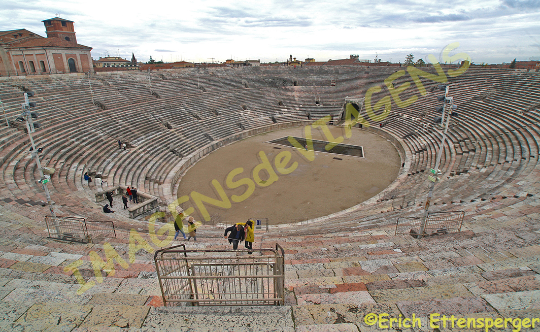
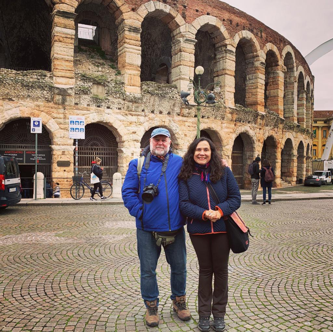
Um dos mais famosos atrativos da cidade é a Arena de Verona (Anfiteatro Romano), uma das maiores edificações construídas pelos romanos. O Festival de Ópera, que acontece nessa arena no verão, atrai milhares de pessoas.
Verona possui dois teatros (Filarmônico e Romano) com programação diversificada durante todo o ano.
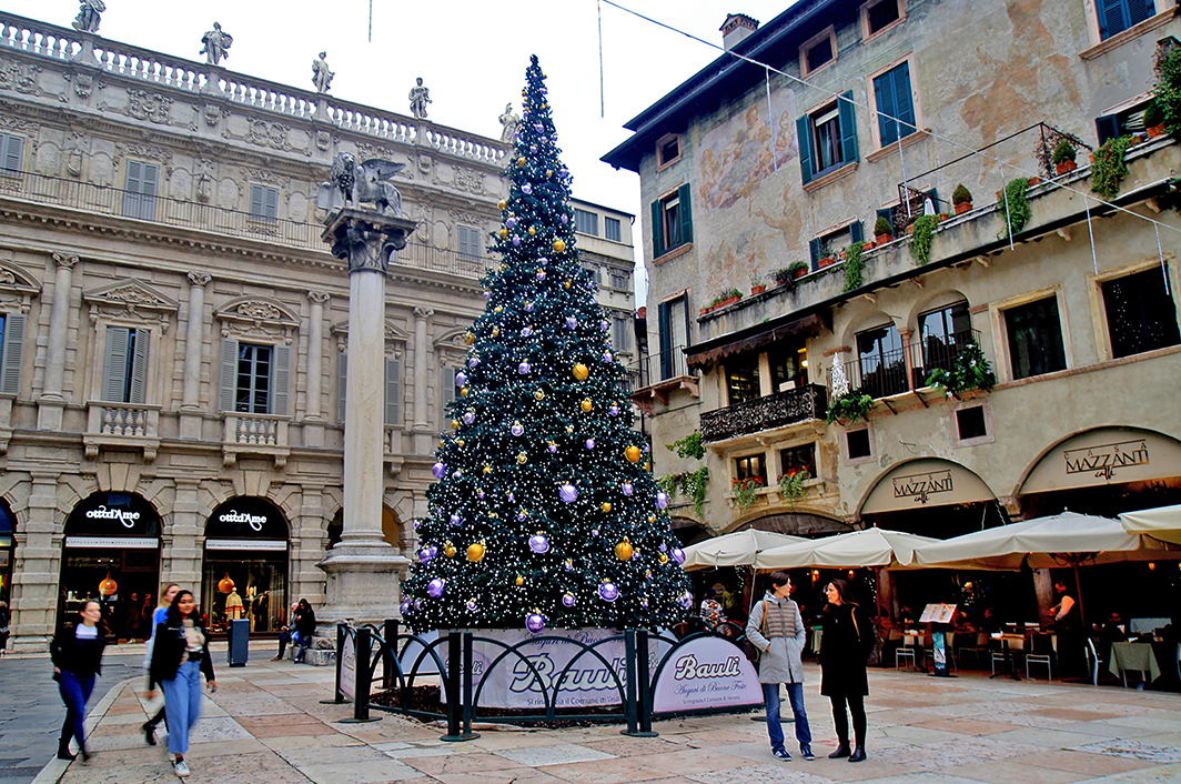
O coração da cidade está localizado na Piazza Erbe, onde existe uma feira de produtos diversos, principalmente souvenires.
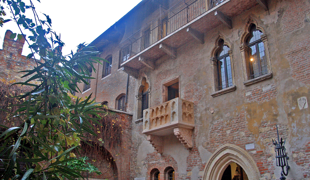
É nas proximidades dessa praça onde está localizada a Rua dos Capelletos com a Casa de Julieta, personagem do drama de Shakespeare (o autor se inspirou numa lenda para escrever a obra).
Próximo a essa praça localiza-se também a casa de Romeo e o interessante Arco Scaligere, além da Ponte de Pedra.
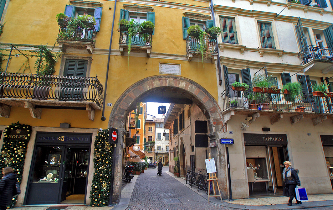
O centro de Verona tem muitas lojas sofisticadas e bem interessantes, de roupas, objetos de arte, souvenires, dentre outras.
Ao lado da Piazza Erbe, com seus restaurantes e bares, encontra-se a Piazza do Signori, onde acontece o lindo Mercado de Natal, cheio de delícias e sabores.
Próxima a essa praça existe uma área com escavações arqueológicas, os Palácios Franchini e o Miniscalchi-Erizzo. Nessa área você também pode visitar a Porta Leoni, a Igreja de São Ferno de Maggiore.
Achei a cidade tão encantadora!
É muito agradável caminhar pela Piazza Bra, próxima à Arena, ao Arco de Lisboa Gavi, aos Corsos (ruas) Cavour e Porta Borsari. Há também outra bela caminhada pela área do Castelvecchio, da Ponte Scaligero,com barraquinhas de produtos típicos, visitar a Igreja de São Bernardinho e a Basílica de San Zeno Maggiore.
Uma outra parte da cidade interessante é a do antigo Teatro Romano, com seu museu (entrada custa 4,50 euros)
e de onde é possível fazer belas fotos de Verona.
Se você for visitar esse atrativo, prepare as pernas, são muitos degraus…Nessa área também é possível visitar o Castelo de São Pedro no alto(tem um bondinho se você não quiser subir a pé), as Igrejas de São Tomaso Cantuariense e dos Santos Nazaro e Celso. Há também o Palácio e Jardin Giusti, que não visitamos devido a chuvinha insistente.
Verona é uma cidade que possui muitas igrejas belas, dentre as quais destacam-se a Catedral, a Igreja de São Giovanni, de Santa Anastácia, dentre outras interessantes.
Visitamos Verona no mês de novembro, com temperatura em tosse 13 graus e uma chuvinha leve. Mas, mesmo assim, vi muitas pessoas com suas sombrinhas passeando pelas ruas. O pátio da Casa de Julieta estava cheio, mesmo chovendo.
Caso você queira escapar do turismo de massa de Veneza, Verona pode ser a cidade-base para você realizar uma excursão de um dia à Veneza. Nas proximidades de Verona você também pode visitar outros lugares interessantes como Vicenza, Padova, Lago do Garda, dentre outras.
Se você quiser conhecer somente Verona, recomendo 2 dias, caso se interesse por museus (são 10), sugiro 3 dias, pois há muito o que se ver. Se você se interessa em visitar igrejas (são 33), palácios (são 28)aprecia arquitetura, então, pode até ficar mais um pouquinho…Se quiser fazer um bate-volta à Veneza, 3 dias. Há trens diários para Veneza, passagem custa 28 euros e tem duração de 1 hora e 10 minutos a 1 hora e meia. A estação de trem de Verona chama-se Porta Nova e a de Veneza, Santa Lúcia.
Dica: recomendo reservar restaurantes. Jantamos no Ristorante Greppia, Bottica Vini e no restaurante do hotel onde nos hospedamos, o Due Torri Hotel.
Observação: se você quiser continuar “viajando” com o nosso blog, clique no botão “seguir” localizado no canto inferior direito dessa página. Você também pode “viajar”
Verona ist eine charmante italienische Stadt in der Region Venetien, 500 km von Rom und etwa 115 km von Venedig entfernt.
Fonte/Quelle/Source: Google Maps
Seit der Vorgeschichte gibt es Aufzeichnungen über menschliche Präsenz. Die Römer gründeten im 1. Jahrhundert v. Chr. die Kolonie Augusta Verona. 49 v. Chr. Verleiht ihm Julius Cäsar den Titel einer Gemeinde. Von da an entwickelte sich die Stadt und wurde so verschönert, dass sie als “kleines Rom” bekannt wurde.
Verona hat ungefähr 260.000 Einwohner und wird von der gewundenen Etsch durchflossen, was ihr einen noch besonderen Charme verleiht, wenn Sie die Stadt vom Museum des Römischen Theaters aus betrachten, ein Blick auf das stadthistorische Ensemble mit Brücken, Türmen, Kirchen und Kathedralen. Dieses Szenario ist definitiv faszinierend.
Verona ist eine kleine, charmante, malerische Stadt mit einem wunderschönen historischen Zentrum.
Idealerweise sollten Sie als Gast im historischen Viertel untergebracht sein, von wo aus Sie die meisten Sehenswürdigkeiten zu Fuß besuchen können.
Eine der bekanntesten hiervon in der Stadt ist die Arena von Verona (römisches Amphitheater), eines der größten von den Römern erbauten Gebäude. Das Opernfestival, das im Sommer in dieser Arena stattfindet, zieht Tausende von Menschen an.
Verona hat zwei Theater (Philharmonie und Roman) mit einem abwechslungsreichen Programm das ganze Jahr über.
Das Herz der Stadt befindet sich auf der Piazza Erbe, wo es eine Messe für verschiedene Produkte gibt, hauptsächlich Souvenirs.
Ganz in der Nähe dieses Platzes, an den sich die Rua dos Capelletos anschlieβt befindet sich die Casa de Julieta, einer Figur in Shakespeares Drama Romeo und Julia (der Autor wurde von einer Legende zum Schreiben dieses Werks inspiriert).
Bei diesem Platz befinden sich neben der Ponte de Pedra (Steinbrücke) auch das Haus von Romeo und der interessante Torbogen Arco Scaligere.
Das Zentrum von Verona hat viele raffinierte und interessante Geschäfte, unter anderem für Kleidung, Kunstgegenstände und Souvenirs.
Neben der Piazza Erbe mit ihren Restaurants und Bars befindet sich die Piazza do Signori, auf der der wunderschöne Weihnachtsmarkt voller Köstlichkeiten und Aromen stattfindet.
Neben diesem Platz befindet sich ein Areal mit archäologischen Ausgrabungen, den Franchini-Palästen und dem Miniscalchi-Erizzo. In diesem Viertel können Sie auch die Porta Leoni, die Kirche San Ferno de Maggiore, besuchen.
Ich finde die Stadt so charmant!
Es ist sehr angenehm, über die Piazza Bra in der Nähe der Arena, des Arco de Lisboa Gavi, den Corsos (Straßen) Cavour und der Porta Borsari zu spazieren.
Es gibt auch einen weiteren schönen Spaziergang durch das Viertel von Castelvecchio von Ponte Scaligero mit Ständen typischer Produkte, um dann die Kirche San Bernardinho und die Basilika San Zeno Maggiore zu besuchen.
Ein weiterer interessanter Teil der Stadt ist das alte römische Theater mit seinem Museum (Eintritt 4,50 Euro),
von dem aus Sie wunderschöne Fotos von Verona machen können.
Falls Sie diese Sehenswürdigkeit besuchen möchten, seien Sie sich der vielen auf Sie wartenden Stufen bewuβt!!!
In diesem Bereich können Sie auch oben die Burg Castelo de São Pedro besuchen oben (es gibt auch eine Seilbahn, falls Sie nicht zu Fuß hinaufgehen wollen), die Kirchen von São Tomaso Cantuariense und die zwei Heiligen Santos Nazaro und Celso. Es gibt dort auch den Palast und den Jardin Giusti, die wir wegen des anhaltenden Regens nicht besucht haben.
Verona ist eine Stadt mit vielen schönen Kirchen, darunter die Kathedrale, die Kirchen St. Giovanni und Santa Anastácia.
Wir besuchten Verona im November mit einer Temperatur von 13 Grad und leichtem Regen. Trotzdem sah ich viele Menschen mit ihren Regenschirmen durch die Straßen schlendern. Der Hof der Casa de Julieta war voll trotz des Regens.
Falls Sie dem Massentourismus in Venedig entfliehen möchten, dann ist Verona die ideale Basisstadt für einen Tagesausflug nach Venedig. In der Nähe von Verona können Sie auch weitere interessante Orte wie Vicenza, Padua und den Gardasee besuchen.
Falls Sie nur Verona kennenlernen möchten, empfehle ich 2 Tage, wenn Sie sich für Museen interessieren (es gibt 10), empfehle ich 3 Tage, da es viel zu sehen gibt. Wenn Sie daran interessiert sind, Kirchen zu besuchen (es gibt 33), Paläste (es gibt 28) Architektur zu schätzen wissen, dann sollten Sie sogar ein bisschen länger bleiben … Fenn Sie eine Rundreise nach Venedig machen möchten, 3 – 4 Tage.
Es gibt tägliche Züge nach Venedig, ein Ticket kostet 28 Euro und dauert 1 Stunde und 10 Minuten bis 1,5 Stunden. Der Bahnhof von Verona heißt Porta Nova und der von Venedig ist Santa Lucia.
Tipp: Ich empfehle Restaurants zu reservieren. Wir aßen im Ristorante Greppia, Bottica Vini und im Hotelrestaurant Due Torri, wo wir auch übernachteten.
Hinweis: Falls Sie unserem Blog folgen wollen, dann klicken Sie unten rechts einfach auf “Weiter”, Sie werden dann zukünftig automatisch informiert. Sie können auch durch Brasilien reisen und unser Buch 66 SEHENSWÜRDIGKEITEN IN BRASILIEN kennenlernen und 66 x Brazil – A Mosaic of Beauties.
Verona – a pearl of the Veneto
Verona is a charming Italian city in the Veneto region, 500 km from Rome and about 115 km from Venice.
Fonte/Quelle/Source: Google Maps
There have been records of human presence since prehistory. The Romans founded in the 1st century BC The colony of Augusta Verona. 49 BC Chr. Julius Caesar gives him the title of parish. From then on, the city developed and was so embellished that it became known as “Little Rome”.
Verona has about 260,000 inhabitants and is traversed by the winding Adige, which gives it an even more special charm if you look at the city from the Museum of the Roman Theater, a view of the urban historical ensemble with bridges, towers, churches and cathedrals. This scenario is definitely fascinating.
Verona is a small, charming, picturesque city with a wonderful historical center.
Ideally, you should be staying in the historic district, from where you can visit most of the sights on foot.
One of the most famous of these in the city is the Verona Arena (Roman amphitheater), one of the largest buildings built by the Romans. The opera festival that takes place in this arena in the summer attracts thousands of people.
Verona has two theaters (Philharmonic and Roman) with a varied program all year round.
The heart of the city is in Piazza Erbe, where there is a fair for various products, mainly souvenirs.
Very close to this square, which is adjoined by Rua dos Capelletos, is the Casa de Julieta, a character in Shakespeare’s drama Romeo and Juliet (the author was inspired to write this work by a).
Next to the Ponte de Pedra (stone bridge) there is also Romeo’s house and the interesting archway Arco Scaligere.
The center of Verona has many nifty and interesting shops for clothes, art objects and souvenirs, among others.
Next to the Piazza Erbe with its restaurants and bars is the Piazza do Signori, where the wonderful Christmas market full of delicacies and flavors takes place.
Next to this square is an area with archaeological excavations, the Franchini Palaces and the Miniscalchi-Erizzo. In this neighborhood you can also visit the Porta Leoni, the church of San Ferno de Maggiore.
I feel the city so charming!
It is very pleasant to stroll in Piazza Bra near the Arena, Arco de Lisboa Gavi, Corsos (streets) Cavour and Porta Borsari.
There is also another nice stroll through the Castelvecchio neighborhood of Ponte Scaligero, with stalls of typical products, to then visit the Church of San Bernardinho and the Basilica of San Zeno Maggiore.
Another interesting part of the city is the old Roman theater with its museum (entrance fee 4.50 euros),
from which you can take beautiful photos of Verona.
If you want to visit this attraction be aware of the many steps waiting for you !!!
In this area you can also visit Castelo de São Pedro above (there is also a cable car if you don’t want to go up on foot), the churches of São Tomaso Cantuariense and the two saints Santos Nazaro and Celso. There is also the palace and the Jardin Giusti, which we did not visit because of the persistent rain.
Verona is a city with many beautiful churches including the cathedral, the churches of St. Giovanni and Santa Anastácia.
We visited Verona in November with a temperature of 13 degrees and light rain. Nevertheless, I saw many people strolling through the streets with their umbrellas. The courtyard of the Casa de Julieta was full despite the rain.
If you want to escape the mass tourism in Venice, Verona is the ideal base city for a day trip to Venice. In the vicinity of Verona you can also visit other interesting places such as Vicenza, Padua and Lake Garda.
In case you just want to get to know Verona I recommend 2 days, if you are interested in museums (there are 10) I recommend 3 days as there is a lot to see. If you are interested in visiting churches (there are 33), palaces (there are 28) appreciating architecture, then you should even stay longer … If you want to make a round trip to Venice, 3 – 4 days .
There are daily trains to Venice, a ticket costs 28 euros and takes 1 hour and 10 minutes to 1.5 hours. Verona station is called Porta Nova and Venice’s is Santa Lucia.
Tip: I recommend reserving restaurants. We ate at Ristorante Greppia, Bottica Vini and the hotel restaurant Due Torri, where we also stayed.
Note: If you want to follow our “Travels” on the blog, simply click on “Seguir” in the lower right corner, you will be then automatically informed in the future. You can continue traveling with us with our book Brazil´s 66 Beautiful Sites and 66 x Brazil – A Mosaic of Beauties.
A Bahia é definitivamente um estado brasileiro rico em belezas naturais e culturais. Erich e eu tivemos o prazer de visitar vários destinos baianos e sempre ficamos impressionados com tantas opções. Foi difícil escolher que atrativos iríamos colocar no nosso livro 66 x Brasil, que apresenta um panorama de muitas das belezas brasileiras.
Nesse post vamos enfatizar a Costa do Cacau, um trecho do litoral baiano pontilhado de praias paradisíacas e atrativos que interessam as pessoas que gostam de atrativos relacionados com a história do Brasil.O municípios que compõem a chamada Costa do Cacau são: Ilhéus,
Nesse texto vamos nos deter nos lugares mais famosos, pois o intuito é despertar em você, o desejo de descobrir o nosso Brasil, (quando a pandemia do Coronavirus terminar), cheio de paisagens tão lindas! Aliás, essa é uma das razões que nos levaram a publicar, através da nossa Imagens de Viagens Editora, o nosso livro 66 x Brasil.
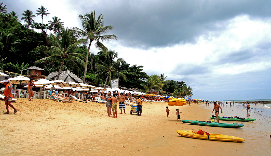
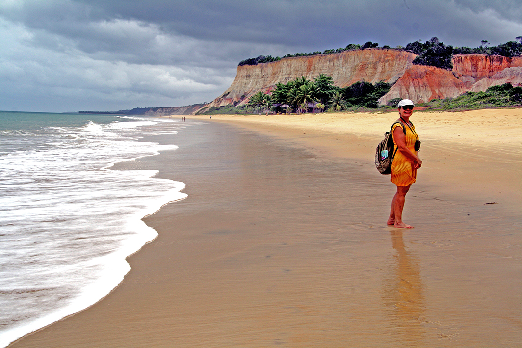
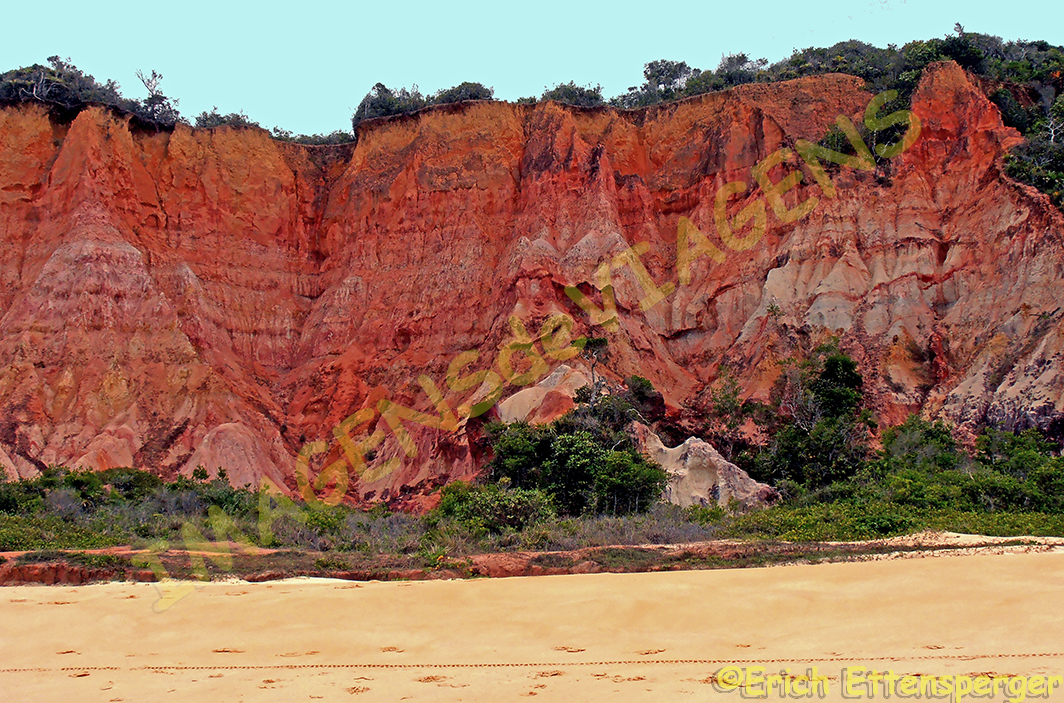
Um dos aspectos que mais nos chamou a atenção nessa parte da Bahia, é a quantidade de belas praias, algumas até quase isoladas, com belos coqueirais e areia branquinha e manguezais densos. Oh, que paraíso natural!
Além disso, estar nessa região é passear por cenários, em Itabuna e Ilhéus, principalmente, que são descritos nos romances do famoso escritor brasileiro Jorge Amado, afinal, estamos na sua terra, que inspirou tantos sucessos, como “Gabriela, Cravo e Canela”, “Tieta do Agreste”, “Capitães de Areia”, dentre muitos outros romances traduzidos para vários idiomas e alguns até que viraram filmes.
Há casarios dos séculos XVIII e XIX, com ruas calçadas de pedra, para quem é gosta de história, é um lugar que oferece atrativos culturais, vale a pena passear pelo centro histórico de Ilhéus, percorrer o circuito Jorge Amado, sentar numa mesinha do Bar Vesúvio e lembra de Gabriela…
Para quem se interessa pelo turismo rural, existem possibilidades de se realizar visitas nas fazendas produtoras de cacau,
se acompanha o processo de produção do chocolate, desde a coleta até o preparo da semente, a produção até a transformação em chocolate. Hum, que delícia!
Para os amantes de praia, de surf, a Costa do Cacau é um destino cheio de atrativos, além de ter uma boa infraestrutura turística.
Se você estiver com tempo, talvez uma boa opção seria alugar um carro e sair de Ilhéus e chegar até Camamu
e de lá pegar um barco até Barra Grande, na Península de Maraú,
você deixa o carro em um dos estacionamentos em Camamu. Nós fizemos assim e tivemos a oportunidade de dirigir pela Estrada Parque, rodeada de verde.
Enfim, a Costa do Cacau na Bahia é definitivamente um destino com muitas opções para você se apaixonar pelas belezas do lugar. Para conhecer mais sobre essa região, clique aqui.
Observação: se você quiser continuar “viajando” com o nosso blog, clique no botão “seguir” localizado no canto inferior direito dessa página. Você também pode “viajar” pelo Brasil conhecendo nosso livro impresso 66 x Brasil e sua versão digital 66 Belezas do Brasil.
Die „Kakaoküste“ – Küste der Schönheit
Bahia ist definitiv ein brasilianischer Staat, der reich an natürlicher und kultureller Schönheit ist. Erich und ich hatten das Vergnügen mehrere bahianische Ziele zu besuchen und wir waren immer beeindruckt von so vielen Möglichkeiten. Es war recht schwierig für uns zu entscheiden, welche Natur-Attraktionen wir in unser Buch 66 x Brasilien aufnehmen würden, das einen Überblick über die vielen brasilianischen Schönheiten bieten soll.
In diesem Beitrag werden wir uns auf die Küste Costa do Cacau konzentrieren, einen Abschnitt der Küste Bahias mit paradiesischen und attraktiven Stränden, auch aufschlussreich und interessant bezüglich der Geschichte Brasiliens.
Die Gemeinden, welche die sogenannte Costa do Cacau formieren sind: Ilhéus,
In diesem Text werden wir an den berühmtesten Orten Halt machen wobei es unsere Absicht ist und war, in Ihnen den Wunsch zu erwecken, in unser Brasilien voller wunderschöner Landschaften einzutauchen (und dies natürlich erst nach der Coronavirus-Pandemie)!!
Bemerkenswert in diesem Teil Bahias ist die Anzahl der schönen Strände, von denen einige sogar fast isoliert versteckt erscheinen, mit wunderschönen Kokospalmen, weißem Sand und dichten Mangroven. Oh, was für ein Naturparadies!
OLYMPUS DIGITAL CAMERA
In dieser Region zu sein bedeutet außerdem, durch Szenarien zu schlendern, hauptsächlich in Itabuna und Ilhéus, die in den Romanen des berühmten brasilianischen Schriftstellers Jorge Amado beschrieben werden. Schließlich befinden wir uns in seinem Territorium, das zu so vielen Erfolgen wie „Gabriela, Cravo e Canela“ inspiriert haben, “Tieta do Agreste”, “Capitães de Areia”, wurden neben vielen anderen Romanen auch in mehrere Sprachen übersetzt und einige davon wurden sogar verfilmt.
Es gibt Häuser aus dem 18. und 19. Jahrhundert mit gepflasterten Straßen. Für diejenigen, die Geschichte mögen, ist es ein Ort, der kulturelle Attraktionen bietet. Es lohnt sich, durch das historische Zentrum von Ilhéus zu schlendern, den Rund-Spaziergang „Jorge Amado“ zu machen und mit ihm an einem Tisch in der Bar Vesuv zu sitzen und er sich gerade an Gabriela… erinnert.
Für diejenigen, die sich für den ländlichen Tourismus interessieren, gibt es Möglichkeiten für Besuche in kakaoproduzierenden Farmen
Sie sehen den gesamten Schokoladenproduktionsprozess, von der Einsammlung/Ernte über die Saatgutzubereitung bis hin zur Produktion und die finale Umwandlung in Schokolade. Ähm, wie lecker!
Für Strand- und Surfliebhaber ist Costa do Cacau ein Reiseziel voller Attraktionen und einer guten touristischen Infrastruktur.
Falls Sie Zeit haben ist es vielleicht eine gute Option, ein Auto zu mieten und Ilhéus zu verlassen und Camamu zu besuchen.
Von dort aus nehmen Sie dann ein Boot nach Barra Grande auf der Halbinsel Maraú.
Sie können das Auto auf einem der Parkplätze in Camamu abstellen. Wir taten dies und hatten somit die Gelegenheit, den von Grün umgebenen Estrada Parque entlang zu fahren.
Wie auch immer, die Kakaoküste in Bahia ist definitiv ein Reiseziel mit vielen Möglichkeiten, um sich in die Schönheit der Regio zu verlieben. Um mehr über diese Region zu erfahren, klicken Sie hier.
Hinweis: Falls Sie unserem Blog folgen wollen, dann klicken Sie unten rechts einfach auf “Weiter”, Sie werden dann zukünftig automatisch informiert. Sie können auch durch Brasilien reisen und unser Buch 66 SEHENSWÜRDIGKEITEN IN BRASILIEN kennenlernen und 66 x Brazil – A Mosaic of Beauties.
The “Cocoa Coast” – Coast of Beauty
Bahia is definitely a Brazilian state rich in natural and cultural beauty. Erich and I had the pleasure of visiting several Bahian destinations and we were always impressed with so many options. It was quite difficult for us to decide which natural attractions we would include in our book 66 x Brazil, which should offer an overview of the many Brazilian beauties.
In this post we will focus on the Costa do Cacau coast (Cocoa Coast), a section of the Bahian coast with paradisiacal and attractive beaches, also revealing and interesting about the history of Brazil.
The municipalities that form the so-called Costa do Cacau are: Ilhéus,
Itacaré, Ipiaú, Maraú, Una, Canavieiras, Itabuna, Uruçuca, Santa Luzia, Pau Brasil and São José da Vitória. There is a lot to see and discover in this region of Bahia!
In this text we will stop at the most famous places and it is our intention and was to make you want to immerse yourself in our Brazil full of beautiful landscapes (and of course only after the coronavirus pandemic)!!
Remarkable in this part of Bahia is the number of beautiful beaches, some of which even seem to be almost isolated, with beautiful coconut trees, white sand and dense mangroves. Oh, what a natural paradise!
OLYMPUS DIGITAL CAMERA
Being in this region also means strolling through scenarios, mainly in Itabuna and Ilhéus, which are described in the novels of the famous Brazilian writer Jorge Amado. After all, we are in his territory, which has inspired so many successes such as “Gabriela, Cravo e Canela”, “Tieta do Agreste”, “Capitães de Areia”, having been translated into many languages and some of them along with many other novels were even filmed.
There are 18th and 19th century houses with cobbled streets. For those who like history, it is a place that offers cultural attractions. It is worth strolling through the historic center of Ilhéus, taking the circular walk “Jorge Amado” and sitting with him at a table in the Vesuvius bar where he is just remembering Gabriela …
For those interested in rural tourism, there are opportunities to visit colonial-style cocoa-producing farms.
You can see the entire chocolate production process, from collection / harvest to seed preparation to production and the final conversion to chocolate. Um, how delicious!
For beach and surf lovers Costa do Cacau is a destination full of attractions and a good tourist infrastructure.
If you have the time, rent a car and leaving Ilhéus and visiting Camamu may be is a good option.
From there take a boat to Barra Grande on the Marau peninsula.
You can park your car in one of the car parks in Camamu. We did this and had the opportunity to drive along the green Estrada Parque.
However, the cocoa coast in Bahia is definitely a travel destination with lots of opportunities to fall in love with the beauty of the region. To learn more about this region, click here
Note: If you want to follow our “Travels” on the blog, simply click on “Seguir” in the lower right corner, you will be then automatically informed in the future. You can continue traveling with us with our book Brazil´s 66 Beautiful Sites and 66 x Brazil – A Mosaic of Beauties.
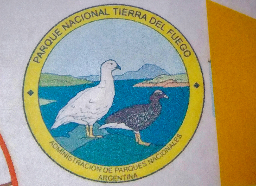
O Parque Nacional Terra do Fogo foi criado em 1960 e está localizado no sul da província da Terra do Fogo
e limita-se com o Chile.
Fonte/Quelle/Source: Google Maps
O parque tem uma área de 68.909 hectares e abrange parte da Cordilheira dos Andes, a costa do Canal Beagle.
A Ilha Grande da Terra do Fogo foi ocupada pelo homem desde 10.000 mil anos. Esse parque possui um clima temperado frio, úmido e sem estação seca, com uma média pluviométrica anual de 700 mm. O período de maior quantidade de chuvas é no outono. A temperatura no inverno fica em torno de 0o. e no verão acima de 10o.
Visitamos o Parque Nacional da Terra do Fogo através de uma excursão vendida pelo cruzeiro no qual viajávamos.
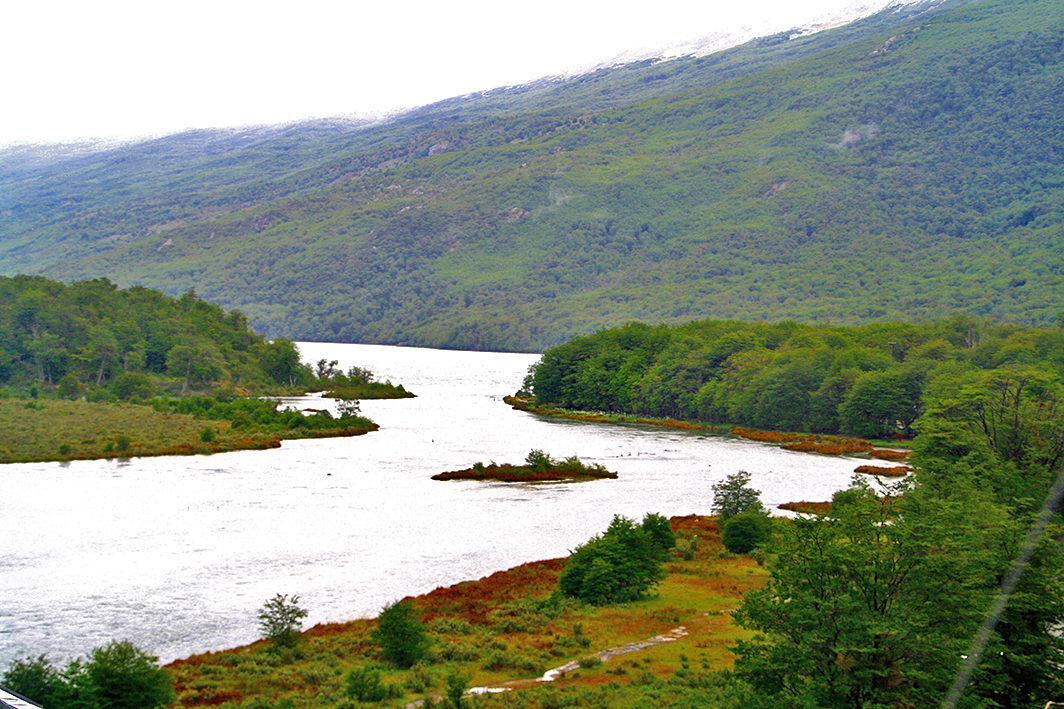
Chegamos lá numa manhã cinzenta e chuvosa, mas, mesmo assim, foi possível apreciar sua vegetação e ver um pouco de sua fauna.
O que me chamou a atenção foram os bosques de árvores chamadas “lengas”, esguias, cujas folhas amarelam durante o outono.
A vegetação desse parque é compreendida pelos Bosques Subantárticos ou Andino Patagônicos, as estepes alto andinas e as turfeiras (áreas compostas por material orgânico). O parque tem uma rica flora, com 90 espécies de árvores, onde se destacam algumas espécies vegetais como a lenga, ñirre ,
guindo, lanterna chinesa, pão de índio, dentre outras. Ele tem uma quantidade limitada de animais silvestres, com aproximadamente 20 tipos de mamíferos , como a raposa vermelha, o rato do mato, a lontra do mar, guanaco, castor-americano,
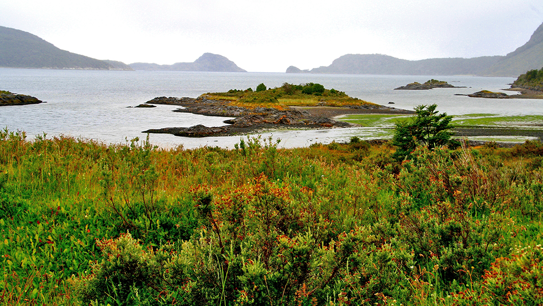
Esse parque nos surpreendeu pela sua extraordinária beleza com cenários emoldurados por montanhas e lagos.
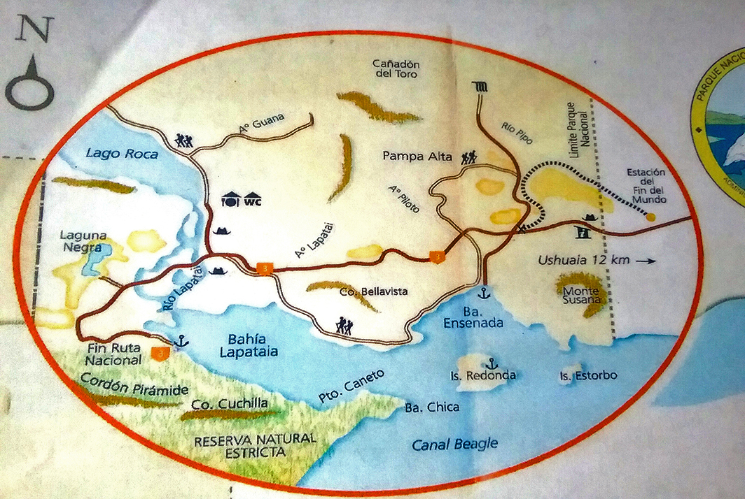
Os locais mais famosos e visitados pelos turistas são Enseada Zaratiegui,
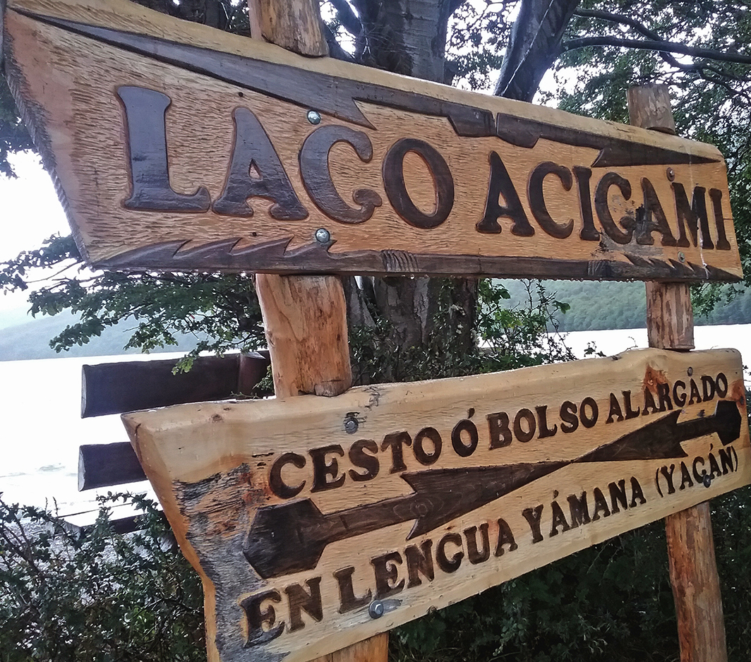
Lago Acigami
e Baía Lapataia
Ele possui a área turística onde existem passarelas com mirantes, como no caso da passarela na área onde finaliza a Rota Pan-americana, a conhecida Rota no. 3 que se extende do Alasca à Terra do Fogo, onde está localizada a Baía Lapataia. Outro ponto com mirante é a Baía Enseada, onde está localizado o Correio do Fim do Mundo.
O Parque Nacional Terra do Fogo tem um Centro de Visitantes Alakush, perto do Lago Acigami, muito interessante com uma exposição permanente sobre os aspectos geográficos, geológicos e etnográficos da área.
Nesse centro tem um mirante com vista para o Lago Roca, atualmente chamado Lago Acigami e o nascente do Rio Laptaia, a Ilha Salmón e o Cerro Cóndor, que separa a Argentina do Chile.
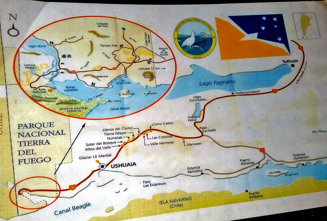
Em resumo, nosso passeio ao Parque Nacional Terra do Fogo foi constituído de quatro paradas: Fim da Rota Nacional mirante, passarela para a Baía Lapataia; Lago Roca, Centro de Visitantes Alakush e Baía Ensenada Zaratiegui, no Canal de Beagle.
O portão de entrada do Parque Nacional Terra do Fogo é a cidade de Ushuaia, ele fica localizado a 12 km.
Você pode visitá-lo através de excursões que são oferecidas pelas agências de turismo locais ou alugar um carro e visitá-lo de forma independente.Há também um minionibus que cuja parada está situada na Av. Maipú e a rua Juana Fadul Recomendo que inicie o passeio pelo Centro de Visitantes do mesmo.
Observação: se você quiser continuar “viajando” com o nosso blog, clique no botão “seguir” localizado no canto inferior direito dessa página. Você também pode “viajar”pelo Brasil conhecendo nosso livro impresso 66 x Brasil e sua versão digital 66 Belezas do Brasil.
Feuerland-Nationalpark
Der Nationalpark Terra do Fogo wurde 1960 gegründet und befindet sich im Süden der Provinz Feuerland
und bildet die Grenze mit Chile.
Fonte/Quelle/Source: Google Maps
Der Park erstreckt sich über eine Fläche von 68.909 Hektar und umfasst einen Teil der Anden, die Küste des Beagle-Kanals.
Die große Insel Feuerland ist seit 10.000 Jahren von Menschen bewohnt. Dieser Park hat ein kaltes gemäßigtes Klima, feucht und ohne Trockenzeit, mit einem jährlichen durchschnittlichen Niederschlag von 700 mm. Die Zeit mit der größten Regenmenge ist im Herbst. Die Wintertemperatur liegt bei 0°C und im Sommer über 10°.
Wir besuchten den Feuerland-Nationalpark während einer Kreuzfahrt.
Wir kamen dort an einem grauen und regnerischen Morgen an, aber trotzdem war es möglich, die Vegetation zu schätzen und etwas von seiner Fauna zu sehen.
Was meine Aufmerksamkeit auf sich zog, waren die schlanken Wälder von Bäumen, die „Lengas“ genannt werden und deren Blätter sich im Herbst gelb verfärben.
Die Vegetation dieses Parks besteht aus den subantarktischen oder andenpatagonischen Wäldern, den hohen Andensteppen und den Torfmooren (Gebiete aus organischem Material). Der Park hat eine reiche Flora mit 90 Baumarten, darunter einige Pflanzenarten wie Lenga, ñirre ,
europäisches Kaninchen, amerikanischer Nerz und die Bisamratte u.a.
Dieser Park überraschte uns für seine außergewöhnliche Schönheit mit einer Landschaft, die von Bergen und Seen umrahmt ist.
Die bekanntesten und meistbesuchten Orte für Touristen sind Enseada Zaratiegui,
Lago Acigami
und Baía Lapataia.
In der Touristengegend gibt es Gehwege mit Aussichtspunkten, wie im Fall des Gehwegs in dem Gebiet, in dem die Panamerikanische Route endet, die bekannte Route Nr. 3, die sich von Alaska bis Feuerland erstreckt(17.848 km), wo sich die Lapataia-Bucht befindet. Ein weiterer Aussichtspunkt ist die Bucht Enseada, in der sich der Correio do Fim do Mundo (das Postamt am Ende der Welt) befindet.
Der Terra do Fogo-Nationalpark verfügt über ein Alakush-Besucherzentrum in der Nähe des Acigami-Sees, das mit einer Dauerausstellung zu den geografischen, geologischen und ethnografischen Aspekten des Gebiets sehr interessant ist.
In diesem Zentrum gibt es einen Aussichtspunkt mit Blick auf den Roca-See, der derzeit als Acigami-See bezeichnet wird, und die Quelle des Flusses Laptaia, der Insel Salmón und des Cerro Cóndor, der Argentinien von Chile trennt.
Zusammenfassend bestand unsere Tour im Terra do Fogo-Nationalpark aus vier Haltestellen: das Ende der Nationalroute R3, Aussichtspunkt, Gehweg zur Lapataia-Bucht; Lago Roca Alakush Besucherzentrum und die Bucht Bay Enseada Zaratiegui am Beagle Channel.
Das Eingangstor zum Terra do Fogo Nationalpark ist die Stadt Ushuaia, die 12 km entfernt liegt.
Sie können es durch Ausflüge besuchen, die von den örtlichen Tourismusagenturen angeboten werden oder ein Auto mieten und es unabhängig besuchen. Es gibt auch einen Minibus, der an den Straßen Av. Maipú und Juana Fadul hält. Beginnen Sie ihren Besuch im Besucherzentrum.
Hinweis: Falls Sie unserem Blog folgen wollen, dann klicken Sie unten rechts einfach auf “Weiter”, Sie werden dann zukünftig automatisch informiert. Sie können auch durch Brasilien reisen und unser Buch 66 SEHENSWÜRDIGKEITEN IN BRASILIEN kennenlernen und 66 x Brazil – A Mosaic of Beauties.
Tierra del Fuego National Park
The Terra do Fogo National Park was founded in 1960 and is located in the south of the Province of Tierra del Fuego
and is restricted to Chile.
Fonte/Quelle/Source: Google Maps
The park covers an area of 68,909 hectares and includes part of the Andes, the coast of the Beagle Channel.
The large island of Tierra del Fuego has been inhabited by people for 10,000 years. This park has a cold temperate climate, humid and dry, with an average annual rainfall of 700 mm. The most rainy season is in autumn. The winter temperature is 0° C and in summer it is over 10°.
We visited Tierra del Fuego National Park during a cruise.
We arrived there on a gray and rainy morning, but it was still possible to appreciate the vegetation and see some of its fauna.
What caught my attention was the slender forests of trees called “Lengas”, whose leaves turn yellow in autumn.
The vegetation of this park consists of the sub-Antarctic or Andean Patagonian forests, the high Andean steppes and the peat bogs (areas made of organic material). The park has a rich flora with 90 tree species, including some plant species such as Lenga, ñirre,
There are a limited number of wild animals including approximately 20 species of mammals such as red fox, bush mouse, sea otter, guanaco, American beaver,
European rabbit, American mink and the muskrat and others.
This park surprised us for its extraordinary beauty with a landscape framed by mountains and lakes.
The most famous and most visited places for tourists are Enseada Zaratiegui,
Lago Acigami
and Baía Lapataia.
In the tourist areas there are sidewalks with viewpoints, as in the case of the sidewalk in the area where the Pan-American route ends, the well-known route No. 3, which extends from Alaska to Tierra del Fuego (17,848 km), where Lapataia Bay is located located. Another vantage point is Enseada Bay, where the Correio do Fim do Mundo (post office at the end of the world) is located.
The Terra do Fogo National Park has an Alakush visitor center near Lake Acigami, which is very interesting with a permanent exhibition on the geographic, geological and ethnographic aspects of the area.
This center has a lookout point that overlooks Lake Roca, now known as Lake Acigami, and the source of the Laptaia River, Salmón Island, and Cerro Cóndor, which separates Argentina from Chile.
In summary, our tour in the Terra do Fogo National Park consisted of four stops: the end of the national route R3, viewpoint, walkway to Lapataia Bay; Lago Roca Alakush Visitor Center and Enseada Zaratiegui on the Beagle Channel.
The gateway to Terra do Fogo National Park is the city of Ushuaia, which is 12 km away.
You can visit it through excursions offered by local tourism agencies or rent a car and visit it independently. There is also a minibus on Av. Maipú and Juana Fadul holds. Start your visit through the visitor center.
Note: If you want to follow our “Travels” on the blog, simply click on “Seguir” in the lower right corner, you will be then automatically informed in the future. You can continue traveling with us with our book Brazil´s 66 Beautiful Sites and 66 x Brazil – A Mosaic of Beauties.
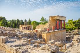
Heraklion ou Heráclito, em português, é a maior cidade de Creta e um dos principais centros urbanos da Grécia e é a capital da Ilha de Creta. Ela possui 170 mil habitantes e está localizada entre duas cadeias de montanhas imponentes: Idi (Monte Psiloritis) a oeste e Dikti (montanhas Lasithiotika) a leste. Seu desenvolvimento começou no início do século IX D.C (na antiguidade, Knossos era o centro mais importante da ilha, seguido por Gortyn). Heráclito foi dominada pelos turcos otomanos, por venezianos e árabes. A cidade sediou torneios de futebol dos Jogos Olímpicos de 2004.
Erich e eu visitamos Heráclito no final da temporada turística em novembro de 2019 e tivemos o prazer de passear por uma cidade agradável com uma ótima infraestrutura turística,
The delicious food in Heraklion…
afinal ela possui um porto muito visitado por cruzeiros.
A very interesting and important tourist sinalization at the floor.It starts at the harbour area.
Para quem gosta de história, Heráclito tem tesouros arqueológicos excepcionais relacionados com a civilização egeia, possui também aldeias pitorescas, grandes vales com olivais e vinhedos, além de possuir a melhor infraestrutura turística da ilha.
Dentre eles, o mais importante é o sitio arqueológico de Cnossos, lendário centro da civilização minoica de 1900 a 1400 aC, localizado a apenas 5 km do centro da cidade e ocupam 20.000 m2 numa área rica em edificações históricas e palácios reais decorados com murais coloridos, característicos da civilização minoica, afinal, a pintura foi a arte por excelência desse povo. O complexo de Cnossos foi destruído pelo terremoto de Santorini (1450 aC). É a atração turística mais importante da ilha.
Fonte/Quelle/Source: https://city-breaker.com/palais-cnossos/ Outro atrativo histórico importante localizado a 63 km de Heráclito são as ruínas do Palácio Phaistos, o segundo em importância na Creta minoica, habitado desde os tempos neolíticos.
Outros atrativos turísticos que se destacam na paisagem urbana dessa cidade portuária são os muros da fortificação em torno do centro antigo que foram construídos pelos árabes e depois, reforçados pelos venezianos durante o século XV.
É muito agradável passear em Heráclito e poder apreciar os vestígios de seu passado rico em história como, por exemplo, conhecer um dos quatro portões que existiam lá. Hoje continua de pé apenas o Chanioporta (1570) com o característico Leão de São Marcos
No coração da cidade, existem muitos monumentos que datam da Idade Média, período em que Heráclito testemunhou grande prosperidade.
Do porto, subindo a Rua 25 Avgoustou (agosto),
chega-se a uma praça onde se encontra a igreja de Agios Titos (construída em 1872 no local onde ficava uma igreja bizantina),
enquanto ao lado fica a Loggia veneziana (século XVI)), um edifício veneziano com arcadas e ricamente decorado, que serviu de ponto de encontro para o duque e outros nobres durante o período veneziano.
Adjacente a ela, fica a capela de Mikros Agios Minas e, a nordeste, situa-se a igreja de Agia Ekaterini (século 16), que funciona como um museu que abriga exposições do Renascimento Cretense. A igreja de Agios Markos (século XIII) se ergue sobre a Praça Venizelou. Outras igrejas relevantes da cidade: Mosteiro de Agios Petros e Pavlos, o Panagia Akrotiriani, o Panagia ton Stavroforon.
A cidade conta também com o Museu Arqueológico, conhecido mundialmente devido seu rico acervo com preciosidades da época minoica desenterrados em Knossos, Phaistos, Malia e outros locais O Museu Histórico de Creta possui obras importantes do pintor El Greco dentre outros mestres, além de apresentar exposições sobre a história de Creta desde o século III d.C.
A cidade possui também o Museu de História Natural de Creta, além do”Cretaquarium” ,na área de Gournes , onde você pode fazer uma imersão no mundo marinho do Mar Mediterraneo. Heráclito possui também uma fortaleza chamada Castelo Koules, oriunda do século XVI, localizada nas margens do mar, foi obra dos venezianos.
Quando caminhamos pela cidade observamos que existem muitas fontes, de origem veneziana e turca. A mais famosa e considerada um dos marcos de Heráclito é a chamada Fonte Morozini, também conhecida como Leões e que data de 1628.
Outras fontes também venezianas e que vale destacar são a fonte Bembo (1552-1554) na Praça Kornaros, a fonte Sagredo (1602-1604) nas proximidades da Loggia e a fonte Priuli (1666) localizada perto do porto. Existem também as fontes de origem turcas, como a fonte Charity (1776), ao lado da fonte Bembo; a “fonte Idomeneas” (atrás do Museu Histórico de Creta), a “fonte Genitsar Aga” (na rua Ikarou). (), dentre outras.
No mercado de Heraklion, um dos mais ricos do Mediterrâneo, os visitantes podem encontrar todos os tipos de produtos modernos, além de produtos tradicionais de Creta, como o famoso azeite de oliva de Creta, raki, vinho local, mel, ervas etc.
Heráclito tem também um campo de golfe, na área de Hersonisos, que opera para iniciantes e para jogadores avançados, opera não muito longe da cidade de Heraklion.
Heráclito conta também com belas praias localizadas em um raio de 30 km. Dentre elas, valem a visita: Agia Pelagia (24 km), Tobrouk (10 km),
Há também passeios que você pode fazer a partir de Heráclito.
There is a tourist bus in HeraklionPrices of taxis from Heraklion to different places
Também gostamos bastante de conhecer Santo Nicolas, com 12 000 habitantes, envolta por montanhas e com a bela baía de Mirabelo, a maior baía de Creta. A cidade possui muitos resorts e hotéis. Rua de pedestres bem agradável com muitos bares e restaurantes, lotados, apesar de não estarmos no verão, estamos em novembro.
Observação: se você quiser continuar “viajando” com o nosso blog, clique no botão “seguir” localizado no canto inferior direito dessa página. Você também pode “viajar”pelo Brasil conhecendo nosso livro impresso 66 Brasil e sua versão digital 66 Belezas do Brasil.
Heraklion – freundliche Hauptstadt Kretas
Heraklion ist die größte Stadt auf Kreta und eines der wichtigsten städtischen Zentren in Griechenland. Es ist die Hauptstadt der Insel Kreta. Sie hat 170.000 Einwohner und liegt zwischen zwei imposanten Gebirgszügen: Idi (Berg Psiloritis) im Westen und Dikti (Lasithiotika-Gebirge) im Osten.
Ihre Entwicklung begann im frühen 9. Jahrhundert n. Chr. (in der Antike war Knossos das wichtigste Zentrum der Insel, gefolgt von Gortyn). Heraklion wurde von osmanischen Türken, Venezianern und Arabern dominiert. Die Stadt veranstaltete Fußballturniere für die Olympischen Spiele 2004.
Erich und ich besuchten Heráclito am Ende der Touristensaison im November 2019 und hatten das Vergnügen durch eine angenehme Stadt mit einer großartigen touristischen Infrastruktur zu schlendern,
The delicious food in Heraklion…
schließlich verfügt sie auch über einen Hafen, der sehr von Kreuzfahrten frequentiert wird.
A very interesting and important tourist sinalization at the floor.It starts at the harbour area.
Für diejenigen, die Geschichte mögen offeriert Heraklion außergewöhnliche archäologische Schätze im Zusammenhang mit der ägäischen Zivilisation, es hat auch malerische Dörfer, große Täler mit Olivenhainen und Weinbergen und verfügt über die beste touristische Infrastruktur auf der Insel.
Unter den wichtigsten ist die archäologische Stätte von Knossos, dem legendären Zentrum der minoischen Zivilisation von 1.900 bis 1.400 v. Chr., das nur 5 km vom Stadtzentrum entfernt liegt und 20.000 m2 in einem Gebiet einnimmt, das reich an historischen Gebäuden und königlichen Palästen ist, die mit farbenfrohen Wandgemälden geschmückt sind. Schließlich war die Malerei, die für die minoische Zivilisation charakteristisch ist, die Kunst schlechthin dieses Volkes. Der Knossos-Komplex wurde durch das Erdbeben auf Santorini (1450 v. Chr.) zerstört. Es ist die wichtigste Touristenattraktion der Insel.
Eine weitere wichtige historische Sehenswürdigkeit, 63 km von Heráclito entfernt, sind die Ruinen des Phaistos-Palastes, der zweitwichtigsten auf dem minoischen Kreta, der seit der Jungsteinzeit bewohnt war.
Weitere Touristenattraktionen, die in der Stadtlandschaft dieser Hafenstadt auffallen, sind die Befestigungsmauern rund um das alte Zentrum, die von den Arabern erbaut und im 15. Jahrhundert von den Venezianern verstärkt wurden.
Es ist sehr angenehm durch Heraklion zu spazieren und die Spuren seiner geschichtsträchtigen Vergangenheit zu bewundern wie zum Beispiel eines der vier dort existierenden Stadttore. Heute stehen nur noch die Chanioporta (1570) mit dem charakteristischen Löwen von São Marcos
und dem Neuen Tor (1587) auf der Südseite von Heraklion.
Im Herzen der Stadt gibt es viele Denkmäler aus dem Mittelalter, einer Zeit, in der Heraklion großen Wohlstand erlebte.
(Vom Hafen aus erreichen Sie in der Avgoustou-Straße 25 (August)
einen Platz, an dem sich die Kirche Agios Titos (erbaut 1872 an der Stelle einer byzantinischen Kirche) befindet.
Daneben befindet sich die venezianische Loggia (16. Jahrhundert)), ein venezianisches Gebäude mit Arkaden und reich verziert, das während der venezianischen Zeit als Treffpunkt für den Herzog und andere Adlige diente.
Unter den Kirchen von Heraklion sticht die imposante und bedeutende Agios Minas (an der Plaza Agia Ekaterini) hervor, die zwischen 1862 und 1895 erbaut wurde.
Angrenzend befindet sich die Kapelle von Mikros Agios Minas und im Nordosten die Kirche von Agia Ekaterini (16. Jahrhundert), die als Museum dient, in dem Ausstellungen der kretischen Renaissance sind. Die Kirche von Agios Markos (13. Jahrhundert) erhebt sich über der Piazza Venizelou. Andere relevante Kirchen in der Stadt: Kloster von Agios Petros und Pavlos, Panagia Akrotiriani, Panagia ton Stavroforon.
Das Archäologische Museum ist weltweit bekannt für seine reiche Sammlung mit Schätzen aus der minoischen Zeit, die in Knossos, Phaistos, Malia und anderen Orten gefunden wurden. Das Historische Museum von Kreta hat neben Ausstellungen auch wichtige Werke des Malers El Greco über die Geschichte Kretas seit dem 3. Jahrhundert n. Chr.
In der Stadt befindet sich neben dem “Cretaquarium” in der Region Gournes auch das Naturkundemuseum von Kreta, in dem Sie in die Meereswelt des Mittelmeeres eintauchen können. Heraklit hat auch eine Festung namens Burg Koules aus dem 16. Jahrhundert, das am Meer gelegen ist und von den Venezianern erbaut wurde.
Uns fiel auf, daβ es viele Brunnen venezianischen und türkischen Ursprungs gibt. Das berühmteste und angesehenste Wahrzeichen von Heraklion ist der sogenannte Morozini -Brunnen, auch Leões genannt, der aus dem Jahr 1628 stammt.
Weitere erwähnenswerte Brunnen sind der Bembo-Brunnen (1552-1554) am Kornaros-Platz, der Sagredo-Brunnen (1602-1604) in der Nähe von Loggia und der Priuli-Brunnen (1666) in der Nähe des Hafens. Es gibt auch Quellen türkischen Ursprungs, wie den Wohltätigkeitsbrunnen (1776) neben dem Bembo-Brunnen; der „Idomeneas-Brunnen“ (hinter dem Historischen Museum von Kreta), der „Genitsar-Aga-Brunnen“ (in der Ikarou-Straße) unter anderen.
Auf dem Heraklion-Markt, einem der reichsten im Mittelmeerraum, finden Besucher neben traditionellen kretischen Produkten wie dem berühmten kretischen Olivenöl, Raki, lokalem Wein, Honig, Kräutern und alle Arten moderner Produkte.
Es gibt auch Touren, die Sie von Heraklion aus unternehmen können.
There is a tourist bus in HeraklionPrices of taxis from Heraklion to different places
Erich und ich besuchten eine Olivenölproduktionsanlage in Vasilakis im Osten der Insel, wo Sie mehr über den gesamten Herstellungsprozess dieses Produkts erfahren können.
Wir besuchten auch gerne Santo Nicolas mit 12.000 Einwohnern, umgeben von Bergen und mit der wunderschönen Bucht von Mirabelo, der größten Bucht Kretas. Die Stadt hat viele Resorts und Hotels. Eine sehr schöne Fußgängerzone mit vielen Bars und Restaurants, voll, obwohl es nicht Sommer war, es war November.
Um mehr über Heraklion zu erfahren, klicken Sie hier.
Hinweis: Falls Sie unserem Blog folgen wollen, dann klicken Sie unten rechts einfach auf “Weiter”, Sie werden dann zukünftig automatisch informiert. Sie können auch durch Brasilien reisen und unser Buch 66 SEHENSWÜRDIGKEITEN IN BRASILIEN kennenlernen und 66 x Brazil – A Mosaic of Beauties.
Heraklion – friendly capital of Crete
Heraklion is the largest city in Crete and one of the most important urban centers in Greece. It is the capital of the island of Crete. It has a population of 170,000 and is located between two imposing mountain ranges: Idi (Psiloritis Mountain) in the west and Dikti (Lasithiotika Mountains) in the east.
Its development began in the early 9th century AD (in ancient times Knossos was the main center of the island, followed by Gortyn). Heraklion was dominated by Ottoman Turks, Venetians and Arabs. The city hosted soccer tournaments for the 2004 Olympic Games.
Erich and I visited Heraklion at the end of the tourist season in November 2019 and had the pleasure of strolling through a pleasant city with a great tourist infrastructure,
after all it also has a port that is very frequented by cruises.
A very interesting and important tourist sinalization at the floor.It starts at the harbour area.
For those who like history, Heraklion offers exceptional archaeological treasures related to the Aegean civilization, it also has picturesque villages, large valleys with olive groves and vineyards and has the best tourist infrastructure on the island.
Among the most important is the archaeological site of Knossos, the legendary center of the Minoan civilization from 1,900 to 1,400 BC., which is only 5 km from the city center and occupies 20,000 m2 in an area rich in historical buildings and royal palaces adorned with colorful murals. After all, painting, which is characteristic of the Minoan civilization, was the very art of this people. The Knossos complex was destroyed by the Santorini earthquake (1,450 BC). It is the main tourist attraction on the island.
Another important historical sight, 63 km from Heraklion, are the ruins of the Phaistos Palace, the second most important in Minoan Crete, which has been inhabited since the Neolithic period.
Other tourist attractions that stand out in the urban landscape of this port city are the ramparts around the old center, built by the Arabs and reinforced by the Venetians in the 15th century.
It is very pleasant to walk through Heraklion and to admire the traces of its historical past, such as one of the four city gates that exist there. Today only the Chanioporta (1570) with the characteristic lion of São Marcos
and the New Gate (1587) stand on the south side of Heraklion.
In the heart of the city there are many monuments from the Middle Ages, a time when Heraklion experienced great prosperity.
From the port at Avgoustou Street 25 (August),
you will reach a place where the church of Agios Titos (built in 1872 on the site of a Byzantine church) is located.
Next to it is the Venetian loggia (16th century), a Venetian building with arcades and richly decorated that served as a meeting point for the Duke and other nobles during the Venetian period.
Among the churches of Heraklion stands out the imposing and important Agios Minas church (on the Plaza Agia Ekaterini), which was built between 1862 and 1895.
Adjacent is the chapel of Mikros Agios Minas and in the northeast the church of Agia Ekaterini (16th century), which serves as a museum where Cretan Renaissance exhibitions are held. The church of Agios Markos (13th century) rises above Piazza Venizelou. Other relevant churches in the city: Monastery of Agios Petros and Pavlos, Panagia Akrotiriani, Panagia ton Stavroforon.
The Archaeological Museum is known worldwide for its rich collection of Minoan treasures found in Knossos, Phaistos, Malia and other places. In addition to exhibitions the Historical Museum of Crete also has important works by the painter El Greco on the history of Crete since the 3rd century AD.
In addition to the “Cretaquarium” in the Gournes region, the city also houses the Natural History Museum of Crete, where you can immerse yourself in the marine world of the Mediterranean. Heraklion also has a 16th-century fortress called Castle Koules, located by the sea and built by the Venetians.
We noticed that there are many fountains of Venetian and Turkish origin. Heraklion’s most famous and prestigious landmark is the so-called Morozini Fountain, also known as Leões, which dates from 1628.
Other fountains worth mentioning are the Bembo fountain (1552-1554) on Kornaros square, the Sagredo fountain (1602-1604) near Loggia and the Priuli fountain (1666) near the port. There are also sources of Turkish origin, such as the Charity Fountain (1776) next to the Bembo Fountain; the “Idomeneas Fountain” (behind the Historical Museum of Crete), the “Genitsar Aga Fountain” (in Ikarou Street) among others.
In the Heraklion market, one of the richest in the Mediterranean, visitors will find traditional Cretan products such as the famous Cretan olive oil, raki, local wine, honey, herbs, etc. and all kinds of modern products.
There are also tours that you can take from Heraklion.
There is a tourist bus in HeraklionPrices of taxis from Heraklion to different places
Erich and I visited an olive oil production facility in Vasilakis in the east of the island, where you can learn more about the entire manufacturing process for this product.
We also liked to visit Santo Nicolas with 12,000 inhabitants, surrounded by mountains and with the beautiful bay of Mirabelo, the largest bay in Crete. The city has many resorts and hotels. A very nice pedestrian area with lots of bars and restaurants, full, although it wasn’t summer, it was November.
Note: If you want to follow our “Travels” on the blog, simply click on “Seguir” in the lower right corner, you will be then automatically informed in the future. You can continue traveling with us with our book Brazil´s 66 Beautiful Sites and 66 x Brazil – A Mosaic of Beauties.
A Bahia é um estado brasileiro rico em atrativos turísticos naturais e culturais, além de possuir um calendário de eventos variado e multicultural. Nessa época de pandemia não estamos viajando, mas, podemos conhecer mais sobre lugares interessantes que poderemos visitar quando a vida voltar ao novo normal. Quando Erich e eu estávamos viajando pelo Brasil para captar imagens para nosso livro 66 x Brasil, tivemos o prazer de conhecer Arraial d´Ajuda.
Arraial d´Ajuda é um distrito do município de Porto Seguro e está localizado a apenas 4 quilômetros de Porto Seguro e 707 km de Salvador. Ele está localizado na parte do litoral baiano conhecido como Costa do Descobrimento. A melhor forma de chegar lá, saindo de Porto Seguro é pegar a balsa e atravessar o Rio Buranhém. É um destino muito procurado pelos que amam o binômio sol e mar.
O que fazer em Arraial d´Ajuda? Curtir as belas praias durante o dia
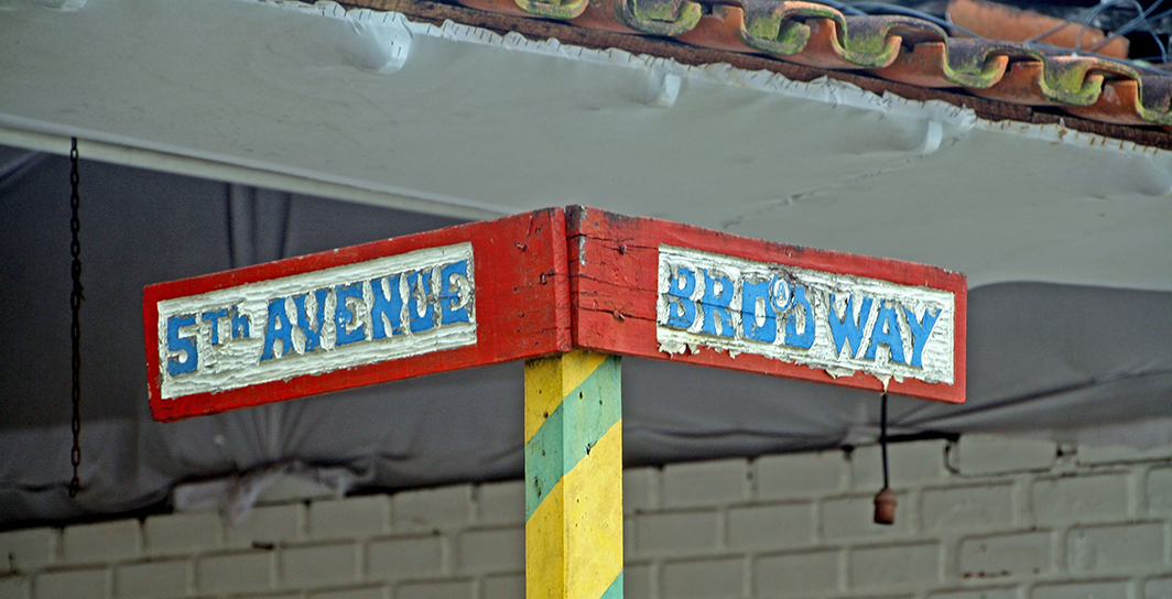
e jantar em um dos muitos restaurantes bacanas localizados ao longo das ruas do Mucugê, da “Broadway” e na Praça da Igreja, onde está localizada a capela.
Você pode visitar a Cidade Histórica, que é a parte onde estão localizadas a Praça da Igreja com a Capela de Nossa Senhora da Ajuda, uma construção colonial que tem um belo altar
e a e também fazer comprinhas nas diversas lojas de souvenires por lá.
Há um mirante com uma bela vista das praias localizado por trás da capela.
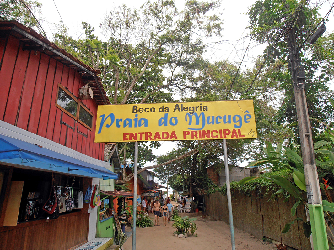
E por falar em praias, vale a visita à praia de Mucugê, é a mais próxima do centro. Para chegar à praia você precisa descer uma ladeira íngreme, que você vai precisar subir quando voltar…
Outra praia legal que você pode alcançar caminhando, é a de Pitinga, que possui muitas barracas. Há também as praias dos Pescadores, do Parracho, Araçaípe e Taípe, sendo a última, mais longe e mais deserta.
As praias de Arraial d´Ajuda tem o mar calmo e propícia para ótimos banhos. Se quiser visitar as piscinas naturais do Parque Marinho de Recife de Fora, você vai encarar uma hora de barco, mas, vale a pena.
tem muito o que fazer em Arraial d´Ajuda. Nós optamos por se hospedar em Trancoso, mas, isso é assunto para outro post.
Observação: se você quiser continuar “viajando” com o nosso blog, clique no botão “seguir” localizado no canto inferior direito dessa página. Você também pode “viajar”
Bahia ist ein brasilianischer Staat, der sehr reich an natürlichen und kulturellen Touristenattraktionen ist und über einen reichen und multikulturellen Veranstaltungskalender verfügt.
Während dieser Pandemie reisen wir nun nicht, aber wir können mehr über interessante Orte erfahren, die wir besuchen können, wenn das Leben zur neuen Normalität zurückkehrt.
Als Erich und ich durch Brasilien reisten, um Bilder für unser Buch 66 x Brasilienaufzunehmen, hatten wir auch das groβe Vergnügen, Arraial d´Ajuda zu besuchen.
Arraial d´Ajuda ist ein Bezirk in der Gemeinde Porto Seguro und liegt nur 4 Kilometer von Porto und 707 Kilometer von Salvador entfernt. Es befindet sich an dem Teil der Bahia-Küste, der als Costa do Descobrimento (Entdeckungsküste) bekannt ist. Der beste Weg, um von Porto Seguro dorthin zu gelangen, ist es, die Fähre zu nehmen und den Fluss Buranhém zu überqueren. Es ist ein beliebtes Ziel für diejenigen, die die Kombination von Sonne und Meer lieben.
Was tun in Arraial d´Ajuda? Genießen Sie tagsüber die schönen Strände
und essen Sie in einem der vielen einladenden Restaurants in den Straßen von Mucugê, am Broadway und am Praça da Igreja, wo sich die Kapelle befindet, zu Abend.
Sie können die historische Altstadt besuchen, in der sich der Kirchplatz mit der Kapelle von Nossa Senhora da Ajuda befindet, ein Kolonialgebäude mit einem schönen Altar
und den verschiedenen Souvenirläden.
Es gibt hinter der Kapelle einen Aussichtspunkt mit einem schönen Blick auf die umliegenden Strände.
Apropos Strände, es lohnt sich, den Mucugê-Strand zu besuchen, der dem Zentrum am nächsten liegt. Um zum Strand zu gelangen müssen Sie einen steilen Hang hinuntergehen, den Sie bei Ihrer Rückkehr wieder erklimmen müssen …
Ein weiterer schöner Strand, den Sie zu Fuß erreichen können, ist Pitinga mit vielen Zelten. Es gibt auch die Strände Pescadores, Parracho, Araçaípe und Taípe, wobei letztere weiter weg und weniger besucht sind.
Die Strände von Arraial d´Ajuda bieten ein ruhiges Meer und eignen sich hervorragend zum Baden. Wenn Sie die natürlichen Pools des Marineparks von Recife de Fora besuchen möchten, müssen Sie eine Stunde auf einem Boot in Kauf nehmen, aber es lohnt sich allemal.
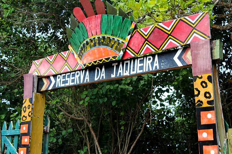
Touren, die Sie von Arraial d´Ajuda aus unternehmen können: Besuchen Sie die Reserva Pataxó da Jaqueira, einen Ort, der von Pataxó-Indianern bewohnt wird (17 km entfernt),
also es gibt viel zu tun in Arraial d´Ajuda. Wir haben uns entschieden, in Trancoso zu bleiben, aber das ist das Thema für einen anderen Beitrag.
Hinweis: Falls Sie unserem Blog folgen wollen, dann klicken Sie unten rechts einfach auf “Weiter”, Sie werden dann zukünftig automatisch informiert. Sie können auch durch Brasilien reisen und unser Buch 66 SEHENSWÜRDIGKEITEN IN BRASILIEN kennenlernen und 66 x Brazil – A Mosaic of Beauties.
The charming Arraial d´Ajuda
Bahia is a Brazilian state that is very rich in natural and cultural tourist attractions and has a rich and multicultural calendar of events.
We are not traveling during this pandemic, but we can learn more about places of interest to visit when life returns to normal.
When Erich and I traveled through Brazil to take pictures for our book 66 x Brazil, we also had the great pleasure of visiting Arraial d´Ajuda.
Arraial d´Ajuda is a district in the municipality of Porto Seguro, just 4 kilometers from Porto and 707 kilometers from Salvador. It is located on the part of the Bahia coast known as the Costa do Descobrimento (Discovery Coast). The best way to get there from Porto Seguro is to take the ferry and cross the Buranhém River. It is a popular destination for those who love the combination of sun and sea.
What to do in Arraial d´Ajuda? Enjoy the beautiful beaches during the day
and have dinner in one of the many inviting restaurants on the streets of Mucugê, Broadway and Praça da Igreja, where the chapel is located.
You can visit the historic old town, where the church square with the chapel of Nossa Senhora da Ajuda is located, a colonial building with a beautiful altar
and various souvenir shops.
There is a viewpoint behind the chapel with an impressive view of the surrounding beaches.
Speaking of beaches it is worth visiting Mucugê beach that is closest to the center. To get to the beach you have to go down a steep slope, which you have to climb again when you return …
Another beautiful beach that you can reach on foot is Pitinga with many tents. There are also the beaches of Pescadores, Parracho, Araçaípe and Taípe, the latter being further away and less visited.
The beaches of Arraial d´Ajuda offer a calm sea and are ideal for swimming. If you want to visit the natural pools of the Recife de Fora Marine Park, you have to take an hour on a boat, but it’s definitely worth it.
so there is a lot to do in Arraial d´Ajuda. We decided to stay in Trancoso, but that’s the topic for another post.
Note: If you want to follow our “Travels” on the blog, simply click on “Seguir” in the lower right corner, you will be then automatically informed in the future. You can continue traveling with us with our book Brazil´s 66 Beautiful Sites and 66 x Brazil – A Mosaic of Beauties.
O Parque Nacional Uluru-Kata Tjuta é um lugar mágico e místico localizado no coração da Austrália, na área chamada como Centro Vermelho.
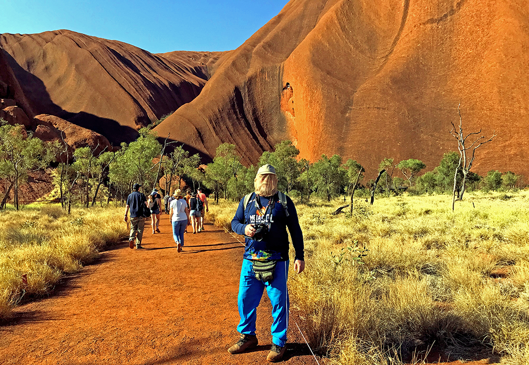
Uluru é um monolítico vermelho gigante reconhecido mundialmente como uma das maravilhas naturais do planeta e centro espiritual dos índios australianos
e Kata Tjuta, são as cúpulas rochosas localizadas a oeste de Uluru.
Esse parque é também conhecido também como Ayers Rock e habitado desde milhões de anos.
É um lugar sagrado para os aborígenes australianos e por isso foi proibida sua escalada a partir de setembro de 2019. É uma das atrações turísticas mais visitadas na Austrália.
Há muitas trilhas em torno da pedra e elas podem ser percorridas de diversas formas: à pé,
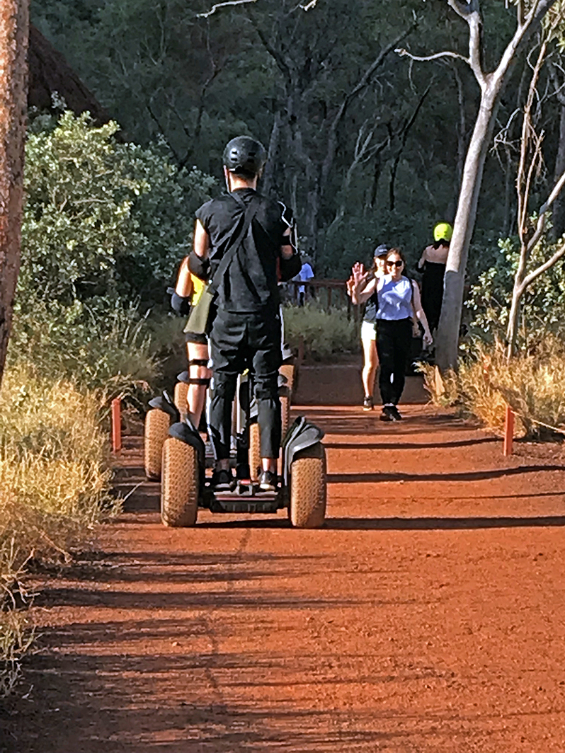
de automóvel, de segway,
de ônibus,
de motocicleta. Apesar de ser apenas uma única rocha, ela tem diferentes faces, caracterizadas por ondulações, cavernas, marcas que o tempo deixou na sua superfície.
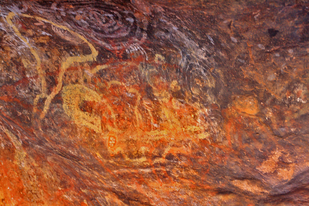
Há também pinturas rupestres que comprovam a presença do ser humano desde milhares de anos.
Uluru é bela o tempo todo e sua beleza muda de acordo com a luz solar, os principais horários para visitar Uluru são para ver o nascer e o por do sol.
No resort há também um centro cultural com loja, café, oficina de artistas.
O parque é administrado pelo governo australiano e pelo povo Anangu, antigos habitantes da região.
Chegamos a Ayers Rock de avião, o aeroporto está localizado ao lado da cidadezinha de Yulara. Erich e eu nos hospedamos no Ayers Rock Resort
Teatro no Resort/Theater at the resortSala de exposição no resort/Exposition room inside of the resort
localizado nas proximidades do parque e é uma das melhores opções para se hospedar nessa área.
Quanto tempo ficar por lá? Nós permanecemos por três dias, sendo um para chegar, no dia seguinte realizar uma excursão pela manhã para visitar as Olgas (um belo grupo de formações rochosas) e outra à tarde para visitar Uluru.
Há outras formas de visitar Uluru, no caso de você dispor de mais tempo. Eu recomendo alugar um carro na cidade de Alice Springs, distante 460 km de Uluru, e visitar outros parques nos arredores.
Em Uluru há outras opções de passeios. A cultura aborígene é muito rica e por isso, se você se interessar, inclua também no seu roteiro, tours e atividades relacionadas com isso.
Para conhecer mais sobre esse parque espetacular, clique aqui e aqui.
Observação: se você quiser continuar “viajando” com o nosso blog, clique no botão “seguir” localizado no canto inferior direito dessa página. Você também pode “viajar” pelo Brasil conhecendo nosso livro impresso 66 Brasil e sua versão digital 66 Belezas do Brasil.
Uluru – der heilige Felsen
Der Uluru-Kata Tjuta National Park ist ein magischer und mystischer Ort im Herzen Australiens in der Region, die als Red Centre (rotes Zentrum) bezeichnet wird.
Uluru ist ein riesiges rotes Monolithikum, das weltweit als eines der Naturwunder des Planeten und als spirituelles Zentrum der australischen Ureinwohner anerkannt ist.
Kata Tjuta sind die felsigen Kuppeln westlich von Uluru.
Dieser Park ist auch als Ayers Rock bekannt und wird seit Millionen von Jahren bewohnt.
Es ist ein heiliger Ort für die australischen Aborigines und daher ist das Besteigen auch seit September 2019 verboten. Uluru ist eine der meistbesuchten Touristenattraktionen in Australien.
Es gibt viele Wege rund um den Monolithen und diese können auf verschiedene Arten zurückgelegt werden: zu Fuß,
mit dem Auto, mit dem Segway,
mit dem Motorrad oder Bus.
Obwohl es nur ein einziger riesiger Stein ist, hat er verschiedene Gesichter, die durch Wellen, Höhlen und Spuren gekennzeichnet sind, die die Zeit auf seiner Oberfläche hinterlassen hat.
Es gibt auch Höhlenmalereien, die die Anwesenheit von Menschen seit Tausenden von Jahren beweisen.
Uluru ist immer schön und seine Schönheit ändert sich je nach dem Sonnenlicht. Als die Hauptzeiten für einen Besuch des Uluru eignen sich jedoch v.a. der Sonnenauf- und Sonnenuntergang.
Im Park gibt es auch ein Kulturzentrum mit einem Geschäft, einem Café und einer Künstlerwerkstatt.
Der Park wird von der australischen Regierung und den Anangu, den ehemaligen Bewohnern der Region, verwaltet.
Wir kamen mit dem Flugzeug in Ayers Rock an, der Flughafen befindet sich neben der kleinen Stadt Yulara. Erich und ich übernachteten im Ayers Rock Resort
Teatro no Resort/Theater at the resortSala de exposição no resort/Exposition room inside of the resort
in der Nähe des Parks und es ist eine der besten Möglichkeiten für einen Aufenthalt in dieser Gegend.
Wieviel Zeit sollte man einplanen? Wir blieben drei Tage, einen, um anzukommen, einen, um am nächsten Morgen einen Ausflug zu machen, um die Olgas (eine wunderschöne Gruppe von Felsformationen) zu besuchen, und einen, um am Nachmittag den Uluru zu besuchen.
Es gibt andere Möglichkeiten, Uluru zu besuchen, falls Sie mehr Zeit haben. Ich empfehle, ein Auto in Alice Springs, 460 km von Uluru entfernt, zu mieten und andere Parks in der Nähe zu besuchen.
In Uluru gibt es weitere Tourmöglichkeiten. Die Kultur der Aborigines ist sehr reichhaltig und kann daher bei Interesse auch in Ihre Reiseroute und Aktivitäten einbezogen werden.
Um mehr über diesen spektakulären Park zu erfahren, klicken Sie hier und hier.
Hinweis: Falls Sie unserem Blog folgen wollen, dann klicken Sie unten rechts einfach auf “Weiter”, Sie werden dann zukünftig automatisch informiert. Sie können auch durch Brasilien reisen und unser Buch 66 SEHENSWÜRDIGKEITEN IN BRASILIEN kennenlernen und 66 x Brazil – A Mosaic of Beauties.
Uluru – the sacred rock
Uluru-Kata Tjuta National Park is a magical and mystical place in the heart of Australia in the region known as the Red Center.
Uluru is a huge red monolithic, recognized worldwide as one of the natural wonders of the planet and as the spiritual center of Australian Aborigines.
Kata Tjuta are the rocky domes west of Uluru.
This park is also known as Ayers Rock and has been inhabited for millions of years.
It is a sacred place for the Australian Aborigines and therefore climbing has been prohibited since September 2019. Uluru is one of the most visited tourist attractions in Australia.
There are many ways around the monolith and these can be covered in different ways: on foot,
by car, by Segway,
by motorcycle or bus.
Although it is only one giant stone it has different faces, which are characterized by waves, caves and traces that time has left on its surface.
There are also cave paintings that prove the presence of humans for thousands of years.
Uluru is always beautiful and its beauty changes depending on the sunlight. However, the main times for a visit to Uluru are: the sunrise and sunset.
In the park there is also a cultural center with a shop, a café and an artist workshop.
The park is managed by the Australian government and the Anangu, the region’s former residents.
We arrived in Ayers Rock by plane, the airport is next to the small town of Yulara. Erich and I stayed at the Ayers Rock Resort
Teatro no Resort/Theater at the resortSala de exposição no resort/Exposition room inside of the resort
near the Park and it is one of the best ways to stay in this area.
How much time should you plan? We stayed three days, one to arrive, one to take a trip the next morning to visit the Olgas (a beautiful group of rock formations) and one to visit Uluru in the afternoon.
There are other ways to visit Uluru if you have more time. I recommend renting a car in Alice Springs, 460 km from Uluru, and visiting other parks nearby.
There are other tour options in Uluru. The Aboriginal culture is very rich and can therefore also be included in your travel route and activities if you are interested.
To learn more about this spectacular Park, click here and here.
Note: If you want to follow our “Travels” on the blog, simply click on “Seguir” in the lower right corner, you will be then automatically informed in the future. You can continue traveling with us with our book Brazil´s 66 Beautiful Sites and 66 x Brazil – A Mosaic of Beauties.
Karlov Vary, também conhecida como Carlsbad, é uma elegante cidade tcheca localizada a 140 km de Praga
e famosa pelas suas águas termais. Ela está situada na parte ocidental da Republica Tcheca, no encontro dos rios Ohre e Teplá. Foi fundada pelo imperador Carlos IV e possui aproximadamente 48.700 habitantes. Ela já era citada em documentos datados do ano de 1350.
Carlsbad recebe anualmente dois milhões de turistas oriundos de 77 países do mundo. As pessoas visitam a cidade atraídas pelo seu ar puro e pelas águas termais.O maior evento de Karlov Vary acontece no final de junho, trata-se do Festival de Cinema, que já está em sua 54ª. Edição.
Mais de 120 filmes, incluindo documentários, já usaram Carlsbad como cenário. Dentre eles: Red Tails (USA 2102), Hostel II (USA 2007), Cassino Royale (USA/GB 2006), Shangai Knights (USA/GB 2003), dentre outros.
Visitamos Carlsbad no verão de 2019 e nos encantamos com a variedade de atrativos existentes na cidade e nos seus arredores como belezas naturais, conjuntos arquitetônicos
com edifícios neoclássicos, barrocos, art noveau, dentre outros estilos
e complexos industriais, como a famosa Indústria Moser que produz os conhecidos cristais da Boemia, desde 1857.
A cidade possui também ótima infraestrutura turística com hotéis de luxo,
spas, represas, rios, florestas.
Vale ressaltar que 65% área da região é coberta por florestas.
No dia em que visitamos Karlov coincidiu com a abertura do 54ª. Festiva de Cinema, ela estava mais reluzente, enfeitada com flores, música e muita gente que já aguardava desde cedo a chegada de artistas e em especial da atriz americana Juliane Moore.
Karlov é definitivamente uma opção de bate-volta para quem quer visitar Praga.
Se você tiver um tempinho a mais, vale a pena pernoitar por lá, porém, recomendamos que a cidade seja visitada durante o verão, quando ela é mais animada e o clima é mais agradável para passeios a pé,
aliás, um dos principais programas, pois a avenida principal é recheada de majestosos edifícios e belas lojas.
Nosso passeio à Carlsbad foi realizado através de um tour bate-volta que saiu de Praga.
Para conhecer mais sobre Karlov Vary, clique aqui.
Observação: se você quiser continuar “viajando” com o nosso blog, clique no botão “seguir” localizado no canto inferior direito dessa página. Você também pode “viajar” pelo Brasil conhecendo nosso livro impresso 66 Brasil e sua versão digital 66 Belezas do Brasil.
Karlsbad – das majestätische Kino
Karlov Vary, auch bekannt als Karlsbad, ist eine elegante tschechische Stadt, 140 km von Prag entfernt und berühmt für ihr Thermalwasser.
Es befindet sich im westlichen Teil der Tschechischen Republik beim Zusammentreffen der Flüsse Ohre und Teplá. Es wurde von Kaiser Karl IV. gegründet und hat ca. 48.700 Einwohner. Es wurde bereits in Dokumenten um 1350 zitiert.
Karlsbad empfängt jährlich zwei Millionen Touristen aus 77 Ländern dieser Welt. Die Menschen besuchen die Stadt, angezogen von sauberer Luft und Thermalwasser. Die größte Veranstaltung von Karlov Vary findet jedoch Ende Juni statt, es ist das InternationaleFilmfestival, das bereits zum 54. Mal stattfindet.
Mehr als 120 Filme, darunter auch Dokumentarfilme, haben Carlsbad als Hintergrundskulisse verwendet. Darunter: Red Tails (USA 2002), Hostel II (USA 2007), Casino Royale (USA / GB 2006), Shanghai Knights (USA / GB 2003), unter anderen.
Wir besuchten Karlsbad im Sommer 2019 und waren verzaubert von der Vielfalt der in und um die Stadt vorhandenen Attraktionen wie Naturschönheiten, architektonischen Komplexen
mit neoklassizistischen, barocken, Art Noveau-Gebäuden und anderen
Industriekomplexen wie der berühmten Moser-Industrie, welche die bekannten Kristalle Böhmens seit 1857 produziert.
Die Stadt vefügt auch über eine ausgezeichnete touristische Infrastruktur mit Luxushotels,
Spas, Dämmen, Flüssen und Wäldern. Erwähnenswert ist, dass 65% der Fläche der Region von Wäldern bedeckt sind.
Der Tag, an dem wir Karlov besuchten, fiel mit der Eröffnung des 54. InternationalenFilmfestivaln zusammen.
Karsbad präsentierte sich hell und farbenfroh, geschmückt mit Blumen, Musik und vielen Menschen, die auf die Ankunft von Künstlern warteten, insbesondere der amerikanischen Schauspielerin Juliane Moore.
Karlsbad ist definitiv eine Option für diejenigen, die Prag besuchen möchten.
Wenn Sie etwas mehr Zeit haben, lohnt es sich auch, über Nacht zu bleiben.
Wir empfehlen jedoch, die Stadt im Sommer zu besuchen, wenn sie lebhafter ist und das Wetter angenehmer zum Spazierengehen ist.
Die Hauptstraße ist voller majestätischer Gebäude und schöner Geschäfte.
Unsere Eintagestour nach Karlsbad hatte ihren Ausgangspunkt in Prag.
Um mehr über Karlov Vary zu erfahren, klicken Sie hier.
Hinweis: Falls Sie unserem Blog folgen wollen, dann klicken Sie unten rechts einfach auf “Weiter”, Sie werden dann zukünftig automatisch informiert. Sie können auch durch Brasilien reisen und unser Buch 66 SEHENSWÜRDIGKEITEN IN BRASILIEN kennenlernen und 66 x Brazil – A Mosaic of Beauties.
Karlovy Vary – the majestic cinema
Karlov Vary, also known as Karlsbad, is an elegant Czech city, 140 km from Prague and famous for its thermal water.
It is located in the western part of the Czech Republic at the confluence of the Ohre and Teplá rivers. It was founded by Emperor Charles IV and has approximately 48,700 inhabitants. It was already cited in documents around 1350.
Karlovy Vary receives two million tourists from 77 countries around the world every year. People visit the city attracted by clean air and thermal water. However, Karlov Vary’s largest event will take place at the end of June, the 54th International Film Festival.
Carlsbad was used in more than 120 films including documentaries as the background backdrop. Among them: Red Tails (USA 2002), Hostel II (USA 2007), Casino Royale (USA / GB 2006), Shanghai Knights (USA / GB 2003), among others.
We visited Karlovy Vary in the summer of 2019 and were enchanted by the variety of attractions available in and around the city such as natural beauties, architectural complexes
with neoclassical, baroque, Art Noveau buildings and other
industrial complexes such as the famous Moser industry, which has been produced the well-known crystals of Bohemia since 1857.
The city also has an excellent tourist infrastructure with luxury hotels,
spas, dams, rivers and forests. It is worth noting that 65% of the area of the region is covered by forests.
The day we visited Karlov coincided with the opening of the 54th International Film Festival.
Karsbad presented himself bright and colorful, decorated with flowers, music and many people who were waiting for the arrival of artists, especially the American actress Juliane Moore.
Karlovy Vary is definitely an option for those who want to visit Prague.
If you have a little more time it is also worth staying overnight.
However, we recommend visiting the city in the summer when it’s livelier and the weather is more pleasant for walking.
The main street is full of majestic buildings and nice shops.
Our one-day tour to Karlovy Vary had its starting point in Prague.
Note: If you want to follow our “Travels” on the blog, simply click on “Seguir” in the lower right corner, you will be then automatically informed in the future. You can continue traveling with us with our book Brazil´s 66 Beautiful Sites and 66 x Brazil – A Mosaic of Beauties.
O Brasil é uma nação rica em belezas naturais e orgulhosa desses atrativos naturais, a Imagem de Viagens Editoras publicou o livro 66 x Brasil (com textos em seis idiomas), onde o (a) leitor (a) pode conhecer muitos desses lugares especiais no nosso país. Durante a elaboração desse livro, Erich e eu viajamos para captar fotos e informações sobre esses destinos. Alguns desses lugares nos impressionaram fortemente. O Parque Nacional do Iguaçu é um desses lugares que vale a pena conhecer e se maravilhar!
Esse parque, juntamente com o Parque Nacional do Iguaçu, na Argentina, formam um dos maiores e espetaculares conjuntos de cachoeiras no mundo com uma extensão de 2700 metros.
é um dos parques mais conhecidos internacionalmente. Ele está localizado no estado do Paraná e sua área abrange terras dos municípios de Céu Azul, Matelândia, Serranópolis do Iguaçu, São Miguel do Iguaçu, Foz do Iguaçu, Capanema, Capitão Leonidas Marques, Lindoeste, Santa Tereza do Oeste e Santa Terezinha do Itaipu, totalizando uma área de 169.697,06 hectares.
Para visitar o parque você deve comprar o ingresso online. Nesse tempo de pandemia, há regras importantes para seguir. Veja aqui preços e regulamento. Há a possibilidade de comprar o “Passaporte Maravilhas” que inclui também uma visita panorâmica à Usina Hidrelétrica de Itaipu
O portão de entrada para se visitar esse parque é pela cidade de Foz de Iguaçu, mas, o turista pode aproveitar a viagem e visitar também o lado do parque localizado na Argentina. Fizemos isso. Primeiro, tentamos ir de ônibus, mas, esperamos muito. Então resolvemos ir de táxi e deu certo. Acertamos um valor com o motorista e ele ficou nos esperando do lado argentino. Nos hospedamos no Hotel Belmont Cataratas, localizado dentro do parque. Ele está fechado no momento devido à pandemia.
Dica legal: quando você visitar Foz de Iguaçu, não deixe de visitar o Parque das Aves, trata-se de um parque temático cheio de belezas naturais.
Observação 1: O Blog Imagens e Viagens cumpre isolamento social. Porém, continuamos publicamos posts sobre belos destinos no mundo porque acreditamos que tudo vai passar e que no momento certo, voltaremos a viajar novamente.
Observação 2: se você quiser continuar “viajando” com o nosso blog, clique no botão “seguir” localizado no canto inferior direito dessa página. Você também pode “viajar”pelo Brasil conhecendo nosso livro impresso 66 Brasil e sua versão digital 66 Belezas do Brasil.
Iguaçu National Park – Schauspiel des Wassers
Brasilien ist eine Nation voller Naturschönheiten und stolz auf all diese natürlichen Attraktionen. Imagem de Viagens Editoras (unser Verlag) veröffentlichte das Buch 66 x Brasilien (mit Fotos und Texten in sechs Sprachen), in dem der Leser viele dieser besonderen Orte kennenlernen kann.
Während des Schreibens dieses Buches reisten Erich und ich sehr intensiv, um Fotos und Informationen über diese Reiseziele aufzunehmen.
Einige dieser Orte haben uns sehr, sehr beeindruckt. Der Iguaçu-Nationalpark ist einer der Orte, die einen Besuch wert sind und die es zu bestaunen gilt!
Dieser Park bildet zusammen mit dem Iguaçu-Nationalpark in Argentinien mit einer Längen-Ausdehnung von 2.700 Metern einen der größten und spektakulärsten Wasserfälle der Welt.
Der Iguaçu-Nationalpark auf brasilianischer Seite wurde 1986 in die Liste des UNESCO-Weltkulturerbesder Vereinten Nationen für Erziehung, Wissenschaft und Kultur aufgenommen.
Dieser Park steht auch auf der Liste der 7 Naturwunder der Welt. Wahlen der New7Wonders Foundation, deren Teilnehmer Internetnutzer aus aller Welt waren. Sehen Sie die Liste dieser Wunder hier.
einer der international bekanntesten Parks. Er befindet sich im Bundesstaat Paraná und umfasst Gebiete der Gemeinden Céu Azul, Matelândia, Serranópolis do Iguaçu, São Miguel do Iguaçu, Foz do Iguaçu, Capanema, Kapitän Leonidas Marques, Lindoeste, Santa Tereza do Oeste und Santa Terezinha do Itaipu mit einer Gesamtfläche von 169.697,06 Hektar.
Um den Park zu besuchen, müssen Sie das Ticket online kaufen. In dieser Zeit der Pandemie müssen wichtige Regeln befolgt werden. Siehe hier ( Preise und Vorschriften. Es besteht die Möglichkeit, den „Passport Maravilhas“ zu kaufen, der auch einen Panoramabesuch zum Wasserkraftwerk Itaipu
Der Zugang zum Park führt durch die Stadt Foz de Iguaçu, aber als Tourist kann man auch die Reise genießen und die Seite des Parks in Argentinien besuchen. So haben wir das gemacht. Zuerst haben wir versucht, mit einem Bus zu fahren, aber wir mussten zu lange warten. Also beschlossen wir, mit dem Taxi zu fahren und dies funktionierte auch. Wir waren uns dann mit dem Fahrer einig, dass er auf der argentinischen Seite auf uns warten würde.
Wir übernachteten im Hotel Belmont Cataratas im Park. Es ist derzeit wegen der Pandemie geschlossen.
Cooler Tipp: Falls Sie Foz de Iguaçu besuchen, sollten Sie unbedingt den Parque das Aves (Vogelpark)besuchen, ein Themenpark voller natürlicher Schönheit.
Hinweis 1: Unser Foto- und Reiseblog stösst im Moment auf soziale Isolation. Wir werden jedoch auch weiterhin Beiträge über wunderschöne Ziele in der ganzen Welt veröffentlichen, weil wir glauben, dass alles vorübergehen wird und wir zum richtigen Zeitpunkt auch wieder in Frieden reisen werden können.
Hinweis 2: Falls Sie unserem Blog folgen wollen, dann klicken Sie unten rechts einfach auf “Weiter”, Sie werden dann zukünftig automatisch informiert. Sie können auch durch Brasilien reisen und unser Buch 66 SEHENSWÜRDIGKEITEN IN BRASILIEN kennenlernen und 66 x Brazil – A Mosaic of Beauties.
Iguaçu National Park – spectacle of water
Brazil is a nation full of natural beauties and proud of all these natural attractions. Imagem de Viagens Editoras (our publisher) published the book 66 x Brasilien (with photos and texts in six languages), in which the reader can get to know many of these very special places.
While writing this book Erich and I traveled extensively to take photos and information about all these travel destinations.
We were very, very impressed with some of these places. The Iguaçu National Park is one of the places worth visiting and to be admired!
Together with the Iguaçu National Park in Argentina this park forms one of the largest and most spectacular waterfalls in the world with a length of 2,700 meters.
This park is also on the list of the 7 natural wonders of the world. New7Wonders Foundation elections, attended by Internet users from around the world. See the list of these miracles here.
is one of the internationally best known parks. It is located in the state of Paraná and comprises areas of the municipalities of Céu Azul, Matelândia, Serranópolis do Iguaçu, São Miguel do Iguaçu, Foz do Iguaçu, Capanema, Captain Leonidas Marques, Lindoeste, Santa Tereza do Oeste and Santa Terezinha do Itaipu with a total area of 169,697.06 hectares.
To visit the Park, you need to buy the ticket online. Important rules must be followed during this pandemic period. See here prices and regulations. It is possible to buy the “Passport Maravilhas”, which also includes a panoramic visit to Itaipu Hydroelectric Plant
Access to the park goes through the city of Foz de Iguaçu, but as a tourist you can also enjoy the trip and visit the side of the park in Argentina. That’s how we did it. At first we tried to take a bus, but we had to wait too long. So we decided to take a taxi and it worked. We then agreed with the driver that he would be waiting for us on the Argentine side.
We stayed at the Belmont Cataratas Hotel in the park. It is currently closed due to the pandemic.
Cool tip: If you visit Foz de Iguaçu, you should definitely visit the Parque das Aves (bird park), a theme park full of natural beauty.
Note 1: Our photo and travel blog is currently experiencing social isolation. However, we will continue to post on beautiful destinations around the world because we believe that everything will pass and we can travel again at the right time in peace.
Note 2: If you want to follow our “Travels” on the blog, simply click on “Seguir” in the lower right corner, you will be then automatically informed in the future. You can continue traveling with us with our book Brazil´s 66 Beautiful Sites and 66 x Brazil – A Mosaic of Beauties.
Apresentar lugares visitados ao redor do mundo e proporcionar um intercâmbio de informações com nossos visitantes./Display places visited around the world and provide an exchange of information with our visitors./Weltweit besuchte Orte vorstellen und einen Informationsaustausch mit unseren Besuchern anregen.